

Minnesota map
Wabasha County map
About 21,574 people live here (Census Bureau, 2024 estimate). The sheet's index lists 300 streets; County Road 4, County Road 2 and Hiawatha Pioneer Trail/Disabled American Veterans Highway/Voyageur Highway cross the most grid squares. Things to do inside the boundary: Wabasha.
Open the map (PDF, US Letter)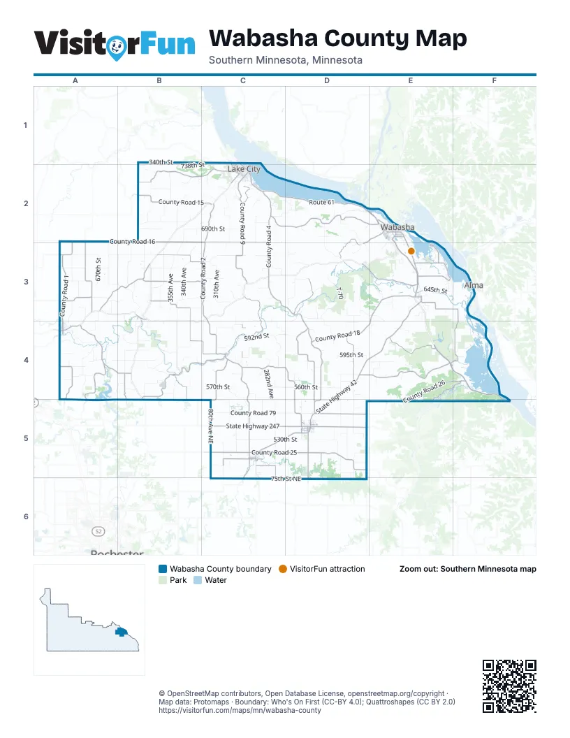
Street index of Wabasha County
Each street on the sheet and the grid squares it crosses.
- Hiawatha Pioneer Trail/Disabled American Veterans Highway/Voyageur HighwayE2, E3, E4, F4, F5
- State Highway 42E3, D4, E4, C5, D5
- Route 61C2, D2, E2
- State Highway 247C5, D5
- Hiawatha Pioneer TrailE2, E3
- West Lyon AvenueC2
- 5th Grant Boulevard WestE2
- 2nd Avenue NortheastA4, C5, D5
- West BroadwayD5
- South Lakeshore DriveC2
- Pembroke AvenueE2
- 2nd Avenue SoutheastA4, C5, D5
- North Lakeshore DriveC1, C2
- South Wabasha StreetD5
- North Wabasha StreetD5
- 2nd StreetD2, E2, B4
- 4th Grant Boulevard WestE2
- Grant Boulevard WestE2
- Pembroke Avenue SouthE2
- Lura Ingalls Wilder Historic HighwayE2
- 116th AvenueF4
- Wabasha-Nelson BridgeE2
- County Road 4C2, C3, D3, D4, D5, D6
- County Road 25C5, D5
- County Road 1A2, A3, A4, A5
- County Road 15B2, C2
- Main StreetB3, B4
- State Highway 60A4
- Hiawatha Drive WestE2
- Shields AvenueE2
- County 9 BoulevardB2
- County Road 10 NortheastD6
- County 11 BoulevardA4
- County Road 2C2, B3, C3, C4, C5, C6
- County Road 11C3, B4, C4
- County Road 7A2, A3, A4, B4
- County Road 14D4, E4
- County Road 8C4, D4, D5
- County Road 86D3, D4, D5
- County Road 18E3, D4, E4
- County Road 10C2, D2, E2
- County Road 72B3, B4, C4
- County Road 9C2, C3
- County Road 5C1, B2, C2
- County Road 84E3, F3, E4, F4
- 300th AvenueB1, B2, C2, C4
- County Road 16A2, B2
- County Road 24E3
- County Road 3A3, B3
- County Road 26E4, F4, E5
- County Road 30D2, D3, E3, D5
- County Road 81D3, E3
- County Road 17B3, C3
- 608th StreetE4
- County Road 27D5
- County Road 31B3, C3, F5
- County Road 23C4, C5
- County Road 21A4, A5
- State Highway 74E4, F4, E5
- County Road 33B2, C2
- County Road 6B4, B5
- County Road 73C5, C6
- County Road 67C5
- Hiawatha Drive EastE2, E3
- 240th AvenueA3, A4, D5
- County Road 83A3
- County Road 80B4, B5
- County Road 76E3
- Bruegger Valley RoadD2, E2, D3
- 1st StreetD2, E2, A3, A4, B4
- 240th Avenue WayA4
- Old County Rd 11B4
- West Lakewood AvenueC2
- 10th StreetC2, E2
- 1st Street SoutheastC5, D5
- Bridge StreetB4, C4
- 4th Avenue SouthwestC5, D5
- 2nd Avenue SouthwestC5, D5
- Main Street WestE2, C5
- East BroadwayD5
- Power Dam RoadA4
- 12th Street EastE2
- 4th Avenue NorthwestC5, D5
- 1st Street SouthwestC5, D5
- Main Street EastE2, C5
- West Monroe StreetC1, C2
- County Road 38C5
- North 10th StreetC1, C2
- Gambia AvenueE2
- County Road 21 NortheastC5
- 10th Street NorthwestD5
- 3rd Street SouthwestD5
- Zumbro StreetD3, C4
- South Dodge StreetE3
- Spring StreetE2, B4
- Bridge AvenueE2
- County Road 11 NortheastB5, C5
- Division StreetC4
- County Road 12A3
- 10th Street SouthwestD5
- County Road 42A3
- West Belvidere AvenueE3
- County Road 41E5
- Phelps AvenueE2
- East Belvidere AvenueE3
- 11th Avenue NortheastA4, B5
- 9th Street SouthwestD5
- Old US Highway 61E3
- County Rd 24 NortheastC6
- Power Dam Road NorthwestA5
- County Road 18 NorthwestA5
- 310th AvenueC2, C3, C5
- County Road 68A3, B3, B4
- 670th StreetA3, C3, E3
- 590th StreetA4, B4, C4, D4, E4
- 592nd StreetC4
- 530th StreetC5, D5
- 355th AvenueB2, B3
- 660th StreetA3, B3, C3
- 275th AvenueC2, C4, C5
- 560th StreetC4, D4, D5
- 215th AvenueD4, D5, D6
- County Road 19D3, E3, D4
- County Road 79C5, D5
- 690th StreetB2, C2
- 225th AvenueD4, D5, D6
- 375th AvenueB2, B3, B4
- 75th Street NortheastC6, D6
- 390th AvenueB3, B4
- 645th StreetB3, E3, F3
- 403rd AvenueA3, B3, A4
- 80th Avenue NortheastC5, C6
- 340th AvenueB2, B3
- County Road 75A2, A3, B3
- County Road 69C3, C4
- County Road 28C4, C5, D5
- 595th StreetA4, D4
- 330th AvenueC4, C5
- County Road 78B2
- County Road 20D2, D3
- 430th AvenueA3
- 386th AvenueB2, B3
- 220th AvenueD3, D5
- 609th StreetB4, C4, D4
- County Road 70B4
- 230th AvenueD2, D4, D5
- 299th AvenueC3, C4, C5
- 570th StreetB4, C4
- County Road 71A4
- 370th AvenueB2, B3
- 235th AvenueD3
- 600th StreetB4, C4, D4
- 340th StreetB1, C1, B2, C2
- 421st AvenueA3, A4
- 345th AvenueB2, B3
- 653rd StreetC3, D3, E3
- 282nd AvenueC4, C5
- County Road 13D3
- 265th AvenueD3, D5, D6
- 593rd StreetB4, C4
- 360th AvenueB3, B4
- 170th AvenueE3, E4
- 738th StreetB1, C1, B2, C2
- 635th StreetA3, B3, E3
- 622nd StreetF3, F4
- 720th StreetB2, C2
- 603rd StreetA4
- County Road 74C4
- 400th AvenueA3, A4, A5
- 639th StreetB3, C3
- 410th AvenueA3, A4
- 625th StreetD3, E3, D4, E4
- County Road 77D2
- 350th AvenueB1, B2, B3, B4
- 661st StreetC3, E3
- 269th AvenueC4
- 290th AvenueC2
- T-22B2
- 363rd AvenueB1, B2, B3
- 260th AvenueD2, D4
- 650th StreetA3, C3, D3
- T-267C5
- South Oak StreetC2
- 229th AvenueD3, D4
- 565th StreetA4, B4, D4
- 255th AvenueD2, D5
- 598th StreetD4, F4
- County Road 22A4
- 575th StreetA4, D4
- 264th AvenueC2, D2
- 712th StreetC2
- 161st AvenueE3, E4
- West Marion StreetC2
- County Road 82B2, B3
- 667th StreetE3
- 672nd StreetD3, E3
- 700th StreetB2, C2, D2
- 733rd StreetB2
- 305th AvenueC3, C4
- 580th StreetD4
- 624th StreetD3
- 209th AvenueD2, D3
- 673rd StreetC3, D3, E3
- T-70D3
- 585th StreetA4, D4
- 351st StreetB4, B5
- T-164B4
- 200th AvenueE4
- T-239C5
- 615th StreetD4, E4
- 605th StreetB4, D4, F4
- 620th StreetD3, D4
- Handshaw Coulee RoadC2
- 415th AvenueA4
- Ryans Bay Road NortheastA5, B5
- 395th AvenueA4, B4
- Clubhouse DriveC2
- 680th StreetC2, D3
- 638th StreetA3
- 380th AvenueB3, B4
- 155th AvenueE3, E4
- 243rd AvenueD2, D3
- 699th StreetC2, D2
- 425th AvenueA3
- 630th StreetB3, C3
- County Road 29F4, F5
- 75th StreetD5, D6
- 166th AvenueE3
- County Road 90A4
- 663rd StreetD3
- 597th StreetB4
- 640th StreetB3, C3
- South 10th StreetC2
- T-183C4
- 210th AvenueD3
- 705th StreetD2
- 302nd AvenueC2
- 85th Street NortheastC5
- 371st AvenueB3, B4
- 550th StreetD5
- 568th StreetB4
- South 670th StreetC3
- 280th AvenueA2, C4
- 185th AvenueE3
- Skyline DriveE3
- Coulee WayE2, E3
- 2nd Avenue NorthwestA4, C5, D5
- 339th AvenueB2
- Ryans Bay RoadA4, A5
- South Garden StreetC2
- 505th StreetD5
- 685th StreetD2
- Olmsted Wabasha County Line RoadC5
- 160th AvenueE3
- 510th StreetC5, D5
- T-247D5
- T-248C5, C6
- 564th StreetF4, F5
- 3rd Avenue NortheastA4, D5
- Chestnut StreetC1, C2, A4
- 285th AvenueC5
- 258th AvenueD3, D4
- 157th AvenueE3, E4
- North 7th StreetC1, C2
- 173rd AvenueE4
- 284th AvenueC4
- 140th AvenueE3, F3
- Carley State Park RoadD5
- T-115D3
- 383rd AvenueB3
- 135th Street NortheastB5
- 202nd AvenueD2, E4
- 604th StreetA4
- 327th AvenueC2
- 143rd AvenueE3
- North Prairie StreetC1, C2
- 642nd StreetD3
- 646th StreetC3
- West Center StreetC2
- Hidden Meadow LaneC1, C2
- T-647A4
- 188th AvenueE3
- North 6th StreetC1, C2
- 520th StreetD5
- South Prairie StreetC2
- Camp Lakeview RoadC2
- Fischer Hill DriveD5
- 708th StreetC2, D2
- North Garden StreetC1, C2
- 250th AvenueD4
- McDougall AvenueE2
- 709th StreetC2, D2
- Bailey AvenueE2
- 573rd StreetB4
- Bennett AvenueF4, F5
- 335th AvenueB2
- 175th AvenueE4
- 135th Street NorthwestA5
- South 6th StreetC2
- 333rd AvenueB2
Things to do on the Wabasha County map
Places on the map
- Bluff Valley Campground
- Camp Victory
- Carley State Park
- Chester Township
- Coffee Mill Country Club
- Elgin
- Elgin Township
- Gillford Township
- Glasgow Township
- Greenfield Township
- Hammond
- Highland Township
- Hyde Park Township
- Kellogg
- Kellogg Weaver Dunes SNA
- Lake Pepin Golf Course
- Lake Township
- Mazeppa
- Mazeppa Township
- Mc Carthy Lake Wildlife Management Area
- McCarthy Lake
- Millville
- Minneiska
- Minneiska Township
- Mount Pleasant Township
- Oakwood Township
- Pepin Township
- Plainview
- Plainview Township
- Richard J. Dorer Memorial Hardwood State Forest
- Robinson Lake
- Steeplechase Ski Hill & Events
- The Jewel Golf Club
- Wabasha
- Watopa Township
- West Albany Township
- West Newton Chute
- Zumbro Falls
- Zumbro Falls Woods SNA
- Zumbro Township
Next to Wabasha County
- Alma
© OpenStreetMap contributors, Open Database License, openstreetmap.org/copyright · Map data: Protomaps · Boundary: Who's On First (CC-BY 4.0); Quattroshapes (CC BY 2.0)















