

Minnesota map
Waconia Township map
About 13,831 people live here (Census Bureau, 2024 estimate). The sheet's index lists 50 streets; 102nd Street, County Road 30 and County Road 32 cross the most grid squares. Also on it: Burandt Lake, Goose Lake and Hydes Lake.
Open the map (PDF, US Letter)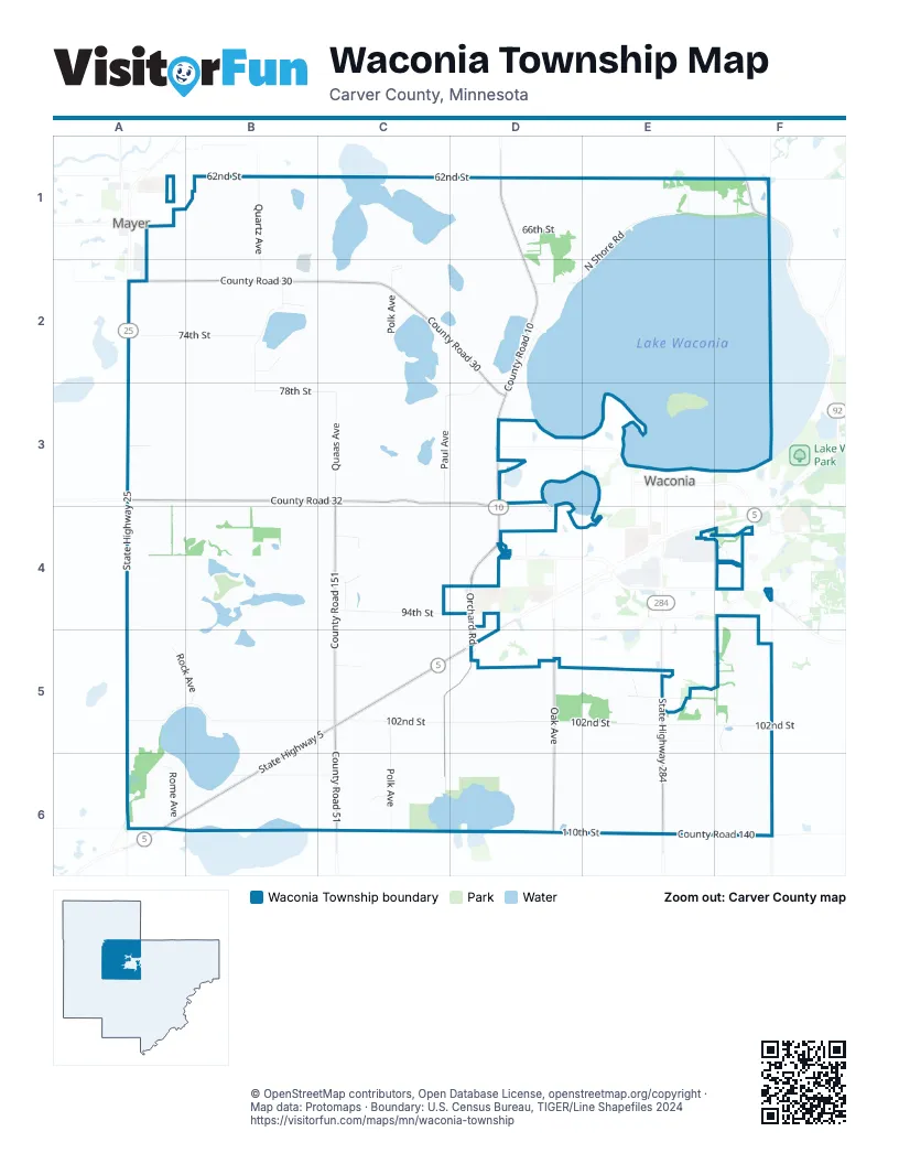
Street index of Waconia Township
Each street on the sheet and the grid squares it crosses.
- 62nd StreetA1, B1, C1, D1
- Quartz AvenueB1, B2
- 66th StreetD1
- County Road 10D1, D2, D3, F4
- Brekke BoulevardE1
- North Shore RoadE1, F1, D2, E2
- County Road 155F1
- 74th StreetA2, B2
- County Road 30A2, B2, C2, D2, D3
- State Highway 25A2, A3, A4, A6
- Heidys LaneB2
- Porter WayB2
- Rutz Lake RoadB2, B3
- Goose Lake DriveC2
- Polk AvenueC2, C5, C6
- 78th StreetD2, B3, C3, D3
- West Shoreline DriveD2
- 82nd StreetA3
- County Road 32A3, B3, C3, D3, D4
- County Road 151C3, C4, C5
- Paul AvenueC3
- Quaas AvenueC3
- Sterling RoadD3
- Waconia Parkway NorthD3, D4
- 92nd StreetA4
- 94th StreetC4, D4
- Appaloosa CircleC4
- Appaloosa DriveC4
- Hackney DriveC4
- Morgan LaneC4
- Orchard RoadD4, C5, D5, C6
- Waconia Parkway SouthD4
- Airport RoadE4
- Hartmann DriveE4, F4
- 10th StreetF4
- 102nd StreetA5, B5, C5, D5, E5, F5
- Rock AvenueA5, B5
- State Highway 5B5, C5, D5, A6, B6
- 98th StreetC5
- County Road 51C5, C6
- Augie Mueller Memorial HighwayD5
- Oak AvenueD5, D6
- Elm Creek RoadE5
- State Highway 284E5, E6
- Cannon Woods TrailF5
- Rome AvenueA6
- 106th StreetB6, C6
- Anthony LaneC6
- 110th StreetD6, E6
- County Road 140E6, F6
Places on the map
- Burandt Lake
- Coney Island
- Dakota Rail Regional Trail Trailhead
- Donders Lake
- Faith Rutz Lake Cemetery
- Goose Lake
- Goose Lake Seaplane Base
- Hydes Lake
- Lake Patterson
- Lake Waconia
- Patterson Lake Wildlife Management Area
- Rutz Lake
- Schneewind Wildlife Management Area
- Sovereign Estate Winery
- Swan Lake
Next to Waconia Township
- Mayer
- Waconia map
© OpenStreetMap contributors, Open Database License, openstreetmap.org/copyright · Map data: Protomaps · Boundary: U.S. Census Bureau, TIGER/Line Shapefiles 2024















