

Minnesota map
Winona map
About 26,173 people live here (Census Bureau, 2024 estimate). The sheet's index lists 300 streets; West 5th Street, West Broadway Street and Homer Road cross the most grid squares. Things to do inside the boundary: Minnesota Marine Art Museum and Polish Cultural Center & Museum.
Open the map (PDF, US Letter)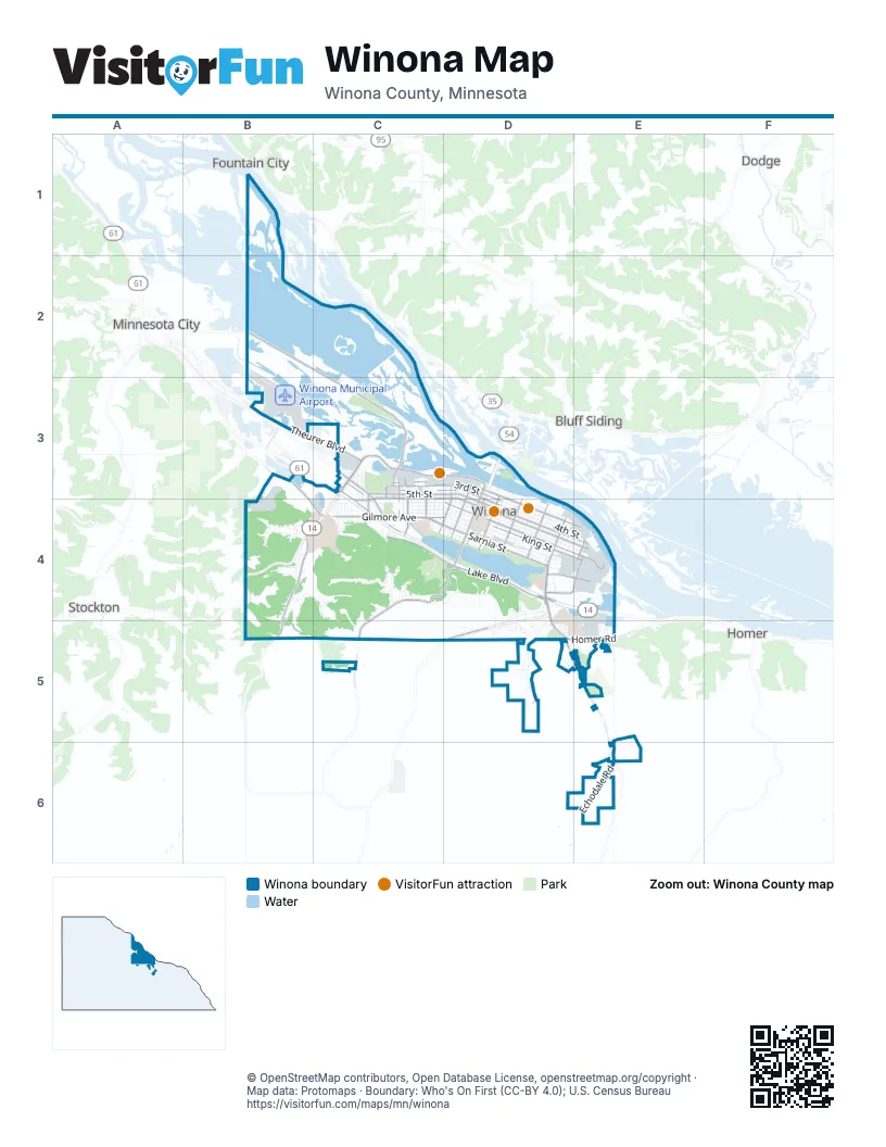
Street index of Winona
Each street on the sheet and the grid squares it crosses.
- Gilmore AvenueC4, D4
- Homer RoadD4, D5, E5
- Mankato AvenueD4
- West Sarnia StreetC4, D4
- West 4th StreetC3, D3, D4
- Main StreetD3, D4
- East Sarnia StreetD4
- West Valley RoadD5
- US 14 / US 61D4
- Orrin StreetC3, C4
- Mankato Avenue / Homer RoadD4
- Black and Yellow Trail/Hiawatha Pioneer Trail / alternate southern routeC3
- Minnesota Highway 43D3, D4
- Hiawatha Pioneer Trail/Disabled American Veterans Highway/Voyageur HighwayC4
- West 5th StreetB3, C3, D3, D4
- West Broadway StreetC3, D3, C4, D4
- Garvin Heights RoadC4, D4, C5
- East Broadway StreetD4, E4
- West Lake BoulevardC4, D4
- Huff StreetD3, D4
- County Highway 21B4
- Pelzer StreetC3
- Gilmore Valley RoadB4, B5
- County Highway 44C5
- Gilmore RidgeB5
- County Highway 32C3, C4
- West 6th StreetC3
- Prairie Island RoadB2, C2, C3
- Riverview DriveC3, D3
- West 3rd StreetC3, D3, D4
- East Sanborn StreetD4, E4
- East King StreetD4, E4
- East 5th StreetD4, E4
- East Lake BoulevardD4
- East 2nd StreetD3, D4, E4
- Theurer BoulevardB3, C3
- Goodview RoadB3, B4, C4
- Hamilton StreetD4
- Pleasant Valley RoadD5, E5
- Franklin StreetD4
- Grand StreetD3, D4
- West 2nd StreetC3, D3
- Sioux StreetD3, C4, D4
- Kramer DriveC3, C4
- Vila StreetC3, C4
- Frontenac DriveD4, E4
- East Service RoadC4
- West Sanborn StreetD4
- Louisa StreetE4
- Winona StreetD4
- Bruski DriveD4, E4
- South Baker StreetC3, C4
- Hilbert StreetC3, C4
- County Road 17E5, E6
- Junction StreetC4
- Jefferson StreetE4
- Bierce StreetC3
- Lee StreetC3
- 54th AvenueB3
- East Wabasha StreetD4, E4
- West Mark StreetC4, D4
- West Wabasha StreetC4, D4
- West King StreetC4, D4
- East 4th StreetD4, E4
- East Mark StreetD4, E4
- East 3rd StreetD4, E4
- East Garvin Heights RoadC4, D4
- West Howard StreetC4, D4
- East Howard StreetD4
- West Service RoadC3, C4
- Shive RoadD4, E4
- Knopp Valley DriveB4
- Valley Oaks DriveD5
- Harriet StreetD3, D4
- East Front StreetD3, D4, E4
- Wilson StreetD3, D4
- Olmstead StreetD3, D4
- Johnson StreetD3, D4
- Lake Park DriveD4
- West Lake StreetC4, D4
- Lafayette StreetD3, D4
- Parks AvenueD4
- West Burns Valley RoadD4, D5
- East Belleview StreetD4
- Carimona StreetD4
- Echodale RoadE6
- West Belleview StreetC4, D4
- Laird StreetD4
- Center StreetD3, D4
- High Forest StreetD4
- Saint Charles StreetD4
- Pleasant Hill DriveB4
- Kansas StreetD4
- West Mill StreetC4, D4
- Ridgewood DriveC4
- Chestnut StreetD4
- Liberty StreetD4
- Chatfield StreetD4
- Zumbro StreetD4
- Bartlet Lake RoadB3, C3
- Old Hwy 43C5, D5
- Vine StreetD4
- Kerry DriveC4
- East Burns Valley RoadD5
- Walnut StreetD3, D4
- Dacota StreetD4
- Wall StreetD4
- Sugar Loaf RoadD4, D5
- Conrad DriveC4
- Cobblestone LaneE6
- Jay Bee DriveB4, C4
- Steuben StreetD4, E4
- Edgewood RoadC4
- Jederman DriveB4
- Bundy BoulevardE4, E5
- Gould StreetC3, C4
- Brookview DriveD5
- Market StreetD4
- Washington StreetD3, D4
- Saint Yons RoadC4
- Storr's Pond RoadD4, D5, E5
- Park DriveD4
- Skyline DriveC4
- Industrial ParkB3
- Buchanan StreetD4, E4
- Waterford CircleE5
- Innovation DriveE4
- Heights BoulevardC4
- Highland DriveC4
- Wilson Twp 27B4
- Country DriveB4
- Wincrest DriveC4
- Debi Lei DriveD5
- Cummings StreetC3, C4
- Michaelwood DriveC4
- Mobile DriveE4
- Adams StreetE4
- Oak Leaf DriveD5
- Wildwood DriveB4
- Valley View DriveE5
- Clarks LaneC4
- Glendale RoadD4
- Club View RoadE5
- Wilkie DriveE5
- Glen Echo RoadD4, D5
- Sunset DriveC4
- Industrial Park RoadB3
- Menard StreetD4
- Sunnyside LaneB4
- Galewski DriveB3
- Tree Tops LaneD5
- Valley Trail DriveB4
- Fairfax StreetC3
- Janet Marie LaneD5
- Stone StreetC3
- Harvester AvenueC3
- Mc Bride StreetD3, D4
- Ewing StreetD3, D4
- Sugar Loaf ViewD4
- Wilsie StreetC4
- Barbara CourtC4
- Crocus CircleD5
- Lenox StreetC3
- Cottonwood DriveC3, C4
- Patneaude DriveB3
- Hiawatha BoulevardC4
- Old Wagon BridgeD3
- Forest Oaks CourtD5
- Lincoln StreetC4
- McNally DriveD5
- Garfield StreetC4
- Glenview DriveD5
- Lorrai DriveE5
- Minnesota StreetC4
- Latsch Island Access RoadD3
- Dresser DriveB4
- Glen Echo LaneD4
- Summit DriveC4
- West 10th StreetD4
- Woodpark RoadC4
- Circle DriveD5, E5
- Ronald AvenueC4
- Bluffview DriveD5
- Twp 3E5
- North Baker StreetC3
- Ralph Scharmer DriveC4
- Trempealeau DriveE4
- McConnon RoadC3
- High StreetC3, C4
- Hickory LaneD5
- Hillview DriveD5
- Ronco AvenueE4
- High RoadD4
- MarianC3
- Candlewood DriveC4
- Eckert StreetC4
- 4th StreetC3
- Wildridge DriveD4
- Lohse DriveD4, D5
- Collegeview StreetC4
- Maceman StreetC4
- Pinecrest RoadE5
- Wabasha StreetC3
- Emherst StreetC3, C4
- Whitten StreetC3
- Crestview DriveC4
- McNally LandingC3
- Birch BoulevardD5
- Riverbend DriveD4
- Parkview AvenueC4
- Breezy LaneE4, E5
- St Johns RoadC4
- Deborah AvenueC4
- Westdale AvenueC4
- Links LaneE5
- Gale StreetC3
- Frontage RoadC4
- Lakeview AvenueC4
- Otis StreetC3
- Elm StreetC3, C4
- Shady Oak CourtD5
- Bluffview CircleC4
- Mechanic StreetC3
- Bridge StreetE4
- Ben StreetC3
- Sebo StreetC3
- Randall StreetC4
- John StreetC3
- Chippewa StreetC4
- Oskamp CircleB4
- Thomas LaneC4
- Glenview RoadD5
- Monroe StreetC3
- Terry LaneC4
- Francis StreetC4
- Oak Park CourtD5
- Glenview CourtD5
- Jackson StreetC3, C4
- Rivers LaneD5
- St Yons RoadC4
- Wayne StreetC4
- Dresser CourtB4
- Hillsdale CourtB4
- Penny LaneD5
- Jimmy Carter PlaceC3, D3
- Rivers Oak CourtD5
- Oakdale LaneD5
- Glen LaneD4
- Hanover StreetC3
- Richmond DriveB4
- Whispering LaneB4, C4
- Country Club RoadE5
- Oak StreetC3, C4
- Harvest LaneB4
- Evergreen LaneD5
- Park LaneC4
- Druey CourtC3
- Edward StreetC3
- Lois LaneD5
- Lane 1D5
- Maple LaneB4
- West 9th StreetD4
- Sunny Ridge LaneE5
- East 25th StreetE4
- Rodeo DriveD5
- Saratoga CourtB4
- 37th AvenueC3
- North StreetC3
- White Oak CourtD5
- Terrace LaneC4
- Whitewater CourtB4
- Marian CourtD4
- Pleasant View LaneE5
- Crest Lok WayB4
- Lane 3D5
- Lane 4D5
- Lane 2D5
- Lane 5D5
- Oakwood CourtD5
- Sharon CourtD4
- Mount Vernon CourtB4
- Warren CourtB4
- Willow LaneB4
- Pumpkin RoadB4
- Diane Loreli LaneD5
- Creekside RoadD5
- Fremont CourtB4
- West Front StreetD3
- Red Oak CourtD5
- Greenview CourtC3
- Verchota LandingB2
- Kerry CourtC4
- Wacouta StreetC4
- Summit StreetC3, C4
- Lorraine CourtC4
- Vista DriveC4
- Johnstone StreetC4
- Wiscoy CourtB4
- Jacob DriveC4
- Wildlife LaneD5
Things to do on the Winona map
Places on the map
- 2 Brothers Sports Bar + Grill
- 5th Street Liquor
- Acoustic Cafe
- Affinity Plus Federal Credit Union Winona Branch
- Airport Lake
- Aldi
- Altra Federal Credit Union Stadium
- Altra Federal Credit Union Winona Branch
- AmericInn by Wyndham Winona
- Bartlet Lake
- Bluffside Park
- Community Memorial Hospital
- Cotter Fields
- Cotter High School
- Fitzgerald Library
- Garvin Heights Vineyard
- Ice Arena
- Indian Channel
- Jefferson Elementary School
- Lake Park
- Lake Winona
- Latsch Island
- Levee Park
- Lions Park
- Loughrey Field
- Menards
- Pleasant Valley Church
- Prairie Island Campground
- Prairie Island Park
- Rileys Lake
- Sugar Loaf
- Walmart Supercenter
- Westfield Golf Club
- Winona Dog Park
- Winona Mall
- Winona Marina
- Winona Middle School
- Winona Municipal Airport
- Winona Senior High School
- Yeomans Pond
Next to Winona
- Bluff Siding
- Dodge
- Fountain City
- Homer
- Minnesota City
- Stockton
© OpenStreetMap contributors, Open Database License, openstreetmap.org/copyright · Map data: Protomaps · Boundary: Who's On First (CC-BY 4.0); U.S. Census Bureau















