

Minnesota map
Winona County map
About 49,973 people live here (Census Bureau, 2024 estimate). The sheet's index lists 300 streets; County Road 25, Main Street and County Road 12 cross the most grid squares. Things to do inside the boundary: Great River Bluffs State Park, Minnesota Marine Art Museum and Polish Cultural Center & Museum.
Open the map (PDF, US Letter)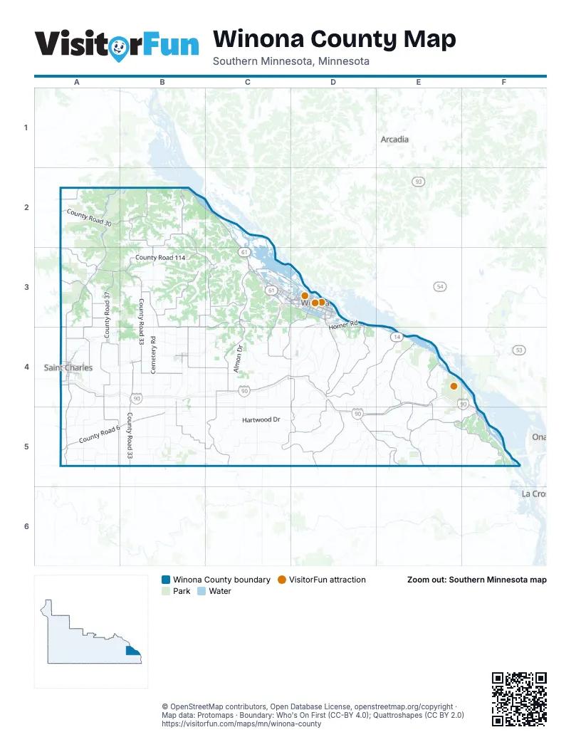
Maps inside Winona County
1 map inside, from the street map of Winona County down.
Street index of Winona County
Each street on the sheet and the grid squares it crosses.
- American Veterans Memorial Highway/State Trooper Theodore Foss Memorial HighwayF5
- Hiawatha Pioneer Trail/Disabled American Veterans Highway/Voyageur HighwayB2, C2, C3, D3
- County Road 19C4, D4, D5
- Homer RoadD3, D4
- Main StreetB3, C3, D3, B4, F5
- Gilmore AvenueC3, D3
- Mankato AvenueD3
- East Main StreetC3, B4
- East 6th StreetC3, A4
- River StreetF5
- County Road 101E4, F4, F5
- West 6th StreetC3, A4
- West Main StreetC3, B4
- West 4th StreetD3, A4
- West Sarnia StreetD3
- East Sarnia StreetD3
- Center StreetD3, B4, F5
- Homer AvenueD3, D4
- West Valley RoadD3, D4
- US 14 / US 61D3
- Jefferson StreetD3
- Hiawatha Pioneer TrailC3
- Orrin StreetD3
- Mankato Avenue / Homer RoadD3
- Sandpiper LaneE4
- Swan LaneE4
- Black and Yellow Trail/Hiawatha Pioneer Trail / alternate southern routeC3
- Minnesota Highway 43D3
- County Road 25B2, A3, B3, C3, B4, C4, C5
- State Highway 74A2, A3, A4, A5
- State Highway 76D5
- County Road 21C4, D4
- West Center StreetA3
- Riverview DriveB2, C3, D3, F5
- West 5th StreetC3, D3, A4
- County Highway 44C4
- West Broadway StreetC3, D3
- Garvin Heights RoadC3, D3, C4
- 6th StreetC3
- Whitewater AvenueA4
- East Broadway StreetD3
- West Lake BoulevardD3
- Huff StreetD3
- County Highway 21C3
- Pelzer StreetC3
- North Main StreetA3
- Liberty AvenueA4
- Fremont StreetB4
- South Main StreetA3, B3
- Gilmore Valley RoadC3
- County Road 32C3
- North Fremont StreetB4
- Gilmore RidgeC3, C4
- County Highway 32D3, B5
- County Road 12C4, D4, E4, D5, E5
- Hiawatha-Appleblossom Scenic DriveE4, E5, F5
- County Road 17D4, C5, D5
- County Road 33B3, B4, B5
- County Road 37A3, A4
- County Road 31B2, B3
- County Road 9D4, E4, E5
- County Road 27A2, B3
- County Road 39A3, A4
- County Road 6A5, B5, E5
- County Road 15D3, D4
- County Road 35A4, A5
- County Road 114B3
- County Road 109B4, B5, C5
- County Road 30A2, B2, E5
- County Road 7E4
- County Road 104E4, D5, E5
- County Road 20B3, C3, B4, C4
- County Road 11D5, E5
- County Road 5E5
- County Road 23C3, C4
- County Road 18B4
- Prairie Island RoadC3, D3
- County Road 26A2, A3, B3, A4
- County Road 8D5, E5
- County Road 23 / F StreetC3
- County Road 113A5
- County Road 110C3
- County Road 28B2
- County Road 119A4
- County Road 115A4
- County Road 125E4, E5
- County Road 41A2
- West 3rd StreetD3, A4
- East 5th StreetD3, A4
- Richland AvenueA4
- East Sanborn StreetD3
- Wabasha AvenueA4
- County Road 43A5
- Theurer BoulevardC3
- County Road 103E5
- East King StreetD3
- East 2nd StreetD3, A4
- Goodview RoadC3
- Wenonah RoadC3
- East Lake BoulevardD3
- 9th StreetC3
- County Road 24A3
- County Road 108A3
- County Highway 104A5, B5
- Bridge StreetC3, D3
- Franklin StreetD3, F5
- Pleasant Valley RoadD3, D4
- Hamilton StreetD3
- Grand StreetD3
- East Center StreetA3
- West 2nd StreetD3
- East 15th StreetA4
- Sioux StreetD3
- Kramer DriveC3, D3
- 12th StreetC3
- Vila StreetD3
- Frontenac DriveD3
- East Service RoadC3, D3
- West Sanborn StreetD3
- 44th AvenueC3
- 54th AvenueC3
- West 1st StreetA4
- County Highway 23 / County Road 23C3
- Louisa StreetD3
- F StreetC3, C4
- Winona StreetD3
- County Highway 17D4
- 41st AvenueC3
- County Rd 22A3
- BroadwayC3
- County Road 10A5
- Bruski DriveD3
- South Baker StreetD3
- Hilbert StreetD3
- West 12th StreetA4
- Junction StreetD3
- South Center StreetB4
- Harbor DriveC3
- Front StreetC3
- Springer AvenueA4
- Schell Hill DriveB2
- Bierce StreetD3
- County Highway 11E5
- Kieffer Hills DriveA4
- Lee StreetD3
- North Center StreetB4
- West 15th StreetA4
- State StreetC3
- Winona RoadC3
- County Highway 25B5
- County Road 30 SoutheastA5
- County Highway 7E4
- Hartwood DriveC5, D5
- Wilson Frontage RoadC4, C5
- Cemetery RoadB3, B4
- County Road 2B5, C5
- Almon DriveB4, C4
- Grover DriveA5, B5
- Cedar Ridge DriveD4, E4
- Wiscoy Twp 18 / Stinson Ridge RoadD5
- County Road 16E5
- Fremont DriveA5, B5
- Fischer Hill DriveA2, A3
- Enterprise Valley DriveB4, C4
- Little Trout Valley RoadE4
- Headwaters DriveD4, D5
- Husman Ridge RoadE4
- Rolling Hills RoadB4
- Pleasant Ridge RoadD4
- County Road 117A4, A5
- Blackberry RoadD4
- East Burns Valley RoadD3, D4
- German Ridge RoadC4
- Whitman Deering DriveB2, C2
- County Road 14B4
- Ferguson Valley DriveB5
- Sandstone DriveA4, B4
- Fairwater RoadA3
- Sinclair RoadA4, A5
- County Road 13D5
- County Road 102C5
- Forester RoadE5
- Bear Creek DriveB3
- Wiscoy Ridge RoadD5
- County Road 116A2
- Keller DriveA5
- Border Line DriveA3, A4, B4
- County Road 111B5
- Lanes Valley RoadF5
- Owl RoadC4
- Cocker DriveA5
- Sievers DriveC5
- Ma Daily RoadA5
- Trestle DriveB4
- Mv Twp 2B2, B3
- Ponderosa RoadB5
- Middle Valley RoadC3
- Sandhill DriveA4, B4
- Nichols Spring DriveA5
- Sylvan Heights RoadA3
- Holstein RoadB3, B4
- Henry DriveA5, B5
- Government Pointe RoadD3, D4
- Dakota Valley DriveE4, E5
- Gilmore Ridge DriveC4
- Heiden RoadC4, C5
- Thompson RoadB4
- New Hartford Twp 3E5, F5
- Hanson Valley RoadD5
- County Road 4C5
- Park RoadA4, E4
- Old Fort RoadA5
- Rollingstone Twp 10B2, C2, C3
- Burns Valley RoadF5
- Rupprecht Valley RoadB3, B4
- White Hawk DriveB3
- East 4th StreetD3, A4
- Bethany DriveB3, B4
- Owls Nest RoadC4
- Grandview Ridge RoadC3
- Lower Bethany DriveB4
- Burt RoadB4
- Rush Creek RoadC4
- Stone Bridge DriveB4, C4
- Whistle Pass DriveB4
- Equine DriveA4
- Pfeiffer RoadD4
- Taylor Hill RoadB2
- Morning Glory DriveC4
- County Road 122D4
- McCarth Ravine RoadA2
- East Wabasha StreetD3
- Cherokee RoadA4
- West Mark StreetC3, D3
- Dutchman's Crossing DriveB4, C4
- Sand Point RoadB4, B5
- County Line DriveC5
- West Wabasha StreetD3
- Quarry Hill RoadC3
- Lady Slipper DriveB4, C4
- Stone Point RoadD4
- Maland DriveB5
- Bobcat RoadE5
- East 3rd StreetD3, A4
- Nagle Ridge DriveD5
- East 9th StreetC3, A4, C4
- County Road 105D4
- Persons DriveA3
- Old Glory RoadA3
- West King StreetC3, D3
- Miner Valley RoadE4
- Utica Line RoadB4
- Hickory DriveB2
- Ferndale RoadC4
- Fremont Store RoadB4, B5
- Daley DriveC4
- Pine Ridge DriveE5
- School Section RoadB5
- East Mark StreetD3
- Kreidemacher RoadA3, B3
- Henderson RoadD5, E5
- Mv Twp 1B2
- Rupprechts Valley RoadB4
- Hm Twp 9E4
- Ridge View RoadC3, C4
- Frank Hill RoadC4
- Starlite DriveC4
- Turkey Hill RoadA4, B4
- Echo Valley DriveE5
- Ph Twp 3E4
- Brosig DriveA3, B3
- Miller Valley RoadE4
- Double M RoadB2
- Reinhard DriveD4
- Century DriveA3
- Horse Shoe RoadB3
- Beaver Ridge DriveA2
- Enterprise RoadB4, B5
- Korona DriveB3
- Lamberton Mill RoadA4
- Monahan DriveB3
- Big Valley DriveC5
- Mv Twp 4B2
- White Avenue DriveB3, C3
- Whitewater DriveA3
- Township Road 17B3, D3, D4
- Ridgeway RoadD4, D5
- Service DriveC3
- Summit DriveD3, A4, B4
- Arches RoadC4
- Tori DriveE5
- Wilderness RoadD4, D5
- Short Cut RoadD5
- Silver Maple RoadD4
- East Garvin Heights RoadD3
- Hiawatha Hills RoadF5
- Slippery Hill RoadE5
- Buffalo Ridge RoadC4
- Worth Cemetery RoadA4, B4, B5
- Green Acres DriveA4
Things to do on the Winona County map
Places on the map
- Altura
- Bartlet Lake
- Bluffside Park
- Bollers Lake
- Dakota
- Dresbach Township
- Elba
- Elba Township
- Fremont Township
- Fruit Acres Apple Orchard
- Goodview
- Great River Bluffs State Park
- Hart Township
- Hillsdale Township
- Homer Township
- Indian Channel
- John A. Latsch State Park
- King's and Queen's Bluffs SNA
- Lake Goodview
- Lake Park
- Lake Winona
- Lewiston
- Minnesota City
- Mount Vernon Township
- New Hartford Township
- Norton Township
- Pleasant Hill Township
- Prairie Island Park
- Richmond Township
- Rileys Lake
- Rollingstone
- Rollingstone Township
- Saint Charles
- Saint Charles Township
- Saratoga Township
- St. Charles Golf Club
- Stockton
- Whitewater State Park
- Whitewater Wildlife Management Area, Main Branch Unit
- Winona Municipal Airport
Next to Winona County
- Arcadia
- La Crescent
- La Crosse
© OpenStreetMap contributors, Open Database License, openstreetmap.org/copyright · Map data: Protomaps · Boundary: Who's On First (CC-BY 4.0); Quattroshapes (CC BY 2.0)















