

Missouri map
Blue Springs map
About 61,246 people live here (Census Bureau, 2024 estimate). The sheet's index lists 300 streets; Dwight D. Eisenhower Highway, Southwest 10th Street and Southwest 9th Street cross the most grid squares. Also on it: Country Club Gardens, Gregory O. Grounds Park and Lake Remembrance.
Open the map (PDF, US Letter)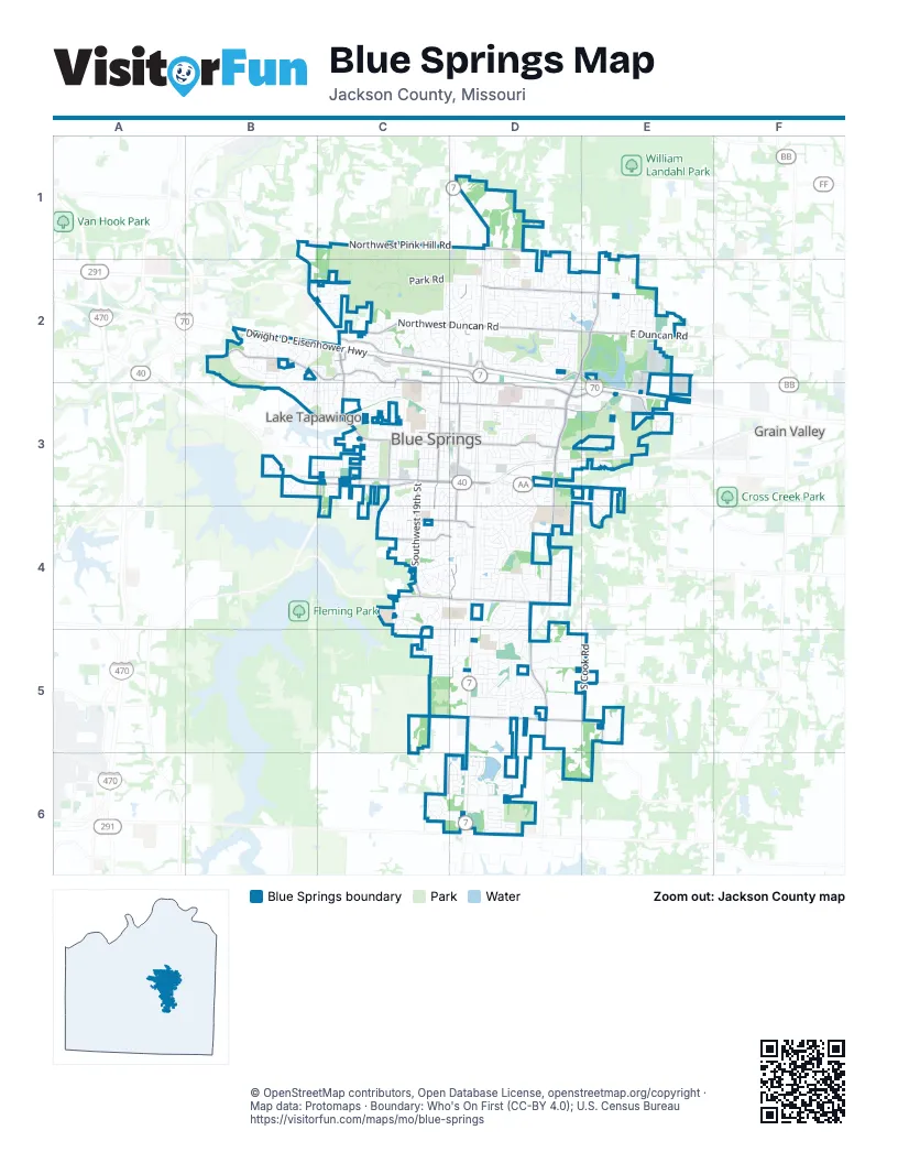
Street index of Blue Springs
Each street on the sheet and the grid squares it crosses.
- Dwight D. Eisenhower HighwayB2, C2, D2, D3, E3
- Corporal M.E. Webster Memorial ParkwayB3, C3, D3
- Northwest Duncan RoadC2, D2
- Southeast Adams Dairy ParkwayD3, D4, D5
- Northeast Adams Dairy ParkwayD2, E2, D3
- Northwest Pink Hill RoadC1, D1
- Northwest Jefferson RoadC2, D2
- Northwest Woods Chapel RoadC2, C3
- Northeast R D Mize RoadD3, E3
- Northeast Jefferson StreetD2, E2, E3
- Southwest Walnut StreetC3, D3
- Southwest Woods Chapel RoadC3, C4
- Southwest Moreland School RoadC4, D4
- Northeast Pink Hill RoadD1, E1
- Northeast Duncan RoadD2, E2
- Northwest R D Mize RoadC3, D3
- Southwest 15th StreetC3, C4, C5
- Southeast Moreland School RoadD4
- Northwest R.D. Mize RoadB1, B2, C2
- East Duncan RoadE2
- Northwest 15th StreetC2, C3
- East Walnut AvenueD3
- Northwest Jefferson StreetD2
- Southeast Wyatt RoadD5
- Northeast Jellison RoadE2
- Southwest Wyatt RoadD5
- West Walnut StreetD3
- Liggett RoadC4
- Northwest Shaw ParkwayD2
- South R.D. Mize RoadB2
- Southwest 10th StreetD3, D4, D5, C6, D6
- Northeast Coronado DriveD3, E3
- Northwest South Outer RoadC2, D2, D3
- Southwest 19th StreetC3, C4
- Northwest Valley View RoadB2, C2
- Northeast Roanoke DriveD2, E2
- Northwest Mock AvenueC2, D2, D3
- East Wyatt RoadC5, D5, E5
- South Cook RoadE5
- Northwest 10th StreetD2, D3
- Southwest Clark RoadC4, D4
- Northwest Ashton DriveC2, C3
- Northwest Kingsridge DriveC2, C3
- West Main StreetC3, D3
- Southwest Mic-O-Say DriveC4, D4
- White Cemetery RoadC3
- Northwest Roanoke DriveD2
- South Shrout RoadD5
- Southwest Quarry RoadC3, C4
- South Litchford RoadE5
- East Major RoadE5
- Northwest Valley View PlaceC2
- East Pink Hill RoadE1
- Northwest Valleyview RoadC2
- R D Mize RoadE3
- Park RoadC2, D2, C3
- Southwest 5th StreetD3, D4, D5, D6
- Southwest 22nd StreetC3, C4, C5
- Northwest Vesper StreetC3, D3
- Southwest 9th StreetD3, D4, D5, C6, D6
- Northwest 12th StreetC2, D2, C3, D3
- Northeast Adams Dairy RoadD2
- Northwest 5th StreetD1, D2, D3
- Southwest 12th StreetC3, D3, C4, C5
- Southeast 2nd StreetD3, D4, D6
- Southwest South AvenueC3, D3
- Northwest 6th StreetD2, D3
- Southwest Liggett RoadC4, D4, D5
- Southeast 6th StreetD4, D5
- Southwest 4th StreetD3, D4, D5, D6
- Northeast 2nd StreetD2, D3
- Southwest 24th StreetC3, C4
- Southwest 23rd StreetC3, C4
- Southwest Morningside DriveC3, C4
- Northeast Porter RoadE2
- Northwest 11th StreetD2, D3
- Southwest 2nd StreetD5, D6
- Southwest Jackson StreetB3, C3
- Southwest 6th StreetD3, D4, D5, D6
- Northeast 3rd StreetD2, D3
- Mason School RoadC6, D6
- Southwest Meyer BoulevardC4
- Southwest 8th StreetD3, D4, D5, D6
- Northwest Canterbury RoadC2, C3
- Southeast Shamrock LaneD4
- Northwest 6th Street TerraceD2, D3
- Northwest Delwood DriveB2, C2, C3
- Southwest 14th StreetC3, C4, C5
- Southwest 21st StreetC3, C4
- Southeast Sunnyside School RoadD3, D4
- Southwest 3rd StreetD3, D4, D5
- Southwest 11th StreetD3, C4, D4
- Northwest 1st StreetD1, D2, D3
- Southwest 16th StreetC3, C4
- Southwest Sunset StreetC3, D3
- Northwest B StreetC3, D3
- Southeast 1st StreetD4, D6
- Southeast 5th StreetD5
- Northeast Sunnyside School RoadD3
- Northwest 3rd StreetD2, D3
- Northwest Castle DriveC3
- Northeast Waterfield DriveD2
- Southwest Major RoadD5
- Southwest 17th StreetC3, C4
- Southwest 18th StreetC3, C4
- Northwest Deer Run TrailC2
- Northeast 5th StreetD2, D3
- Northwest 4th StreetD1, D2, D3
- Southwest Westminister RoadD3, D4
- Southwest Keystone DriveD4
- Northeast 23rd StreetE2
- Southeast Adams DriveD4, D5
- South Speas DriveD3, D4
- Northwest Briarwood DriveB2, B3, C3
- Southwest Shadow Brook DriveC3
- Northeast Waterfield LaneD2
- Northwest Mill DriveC3
- Park AvenueC5
- Northeast Locust DriveD2
- Southwest Kings Cross RoadD3, D4
- Southwest Stonecreek DriveC4, D4
- Southeast Hudson DriveD5
- Southwest Burris RoadC3, C4
- Southeast Piccadilly StreetD3, D4
- Jefferson StreetB2, C2
- Southwest 13th StreetC3, C4, C5
- Northeast Springbrook StreetD2
- Southwest Skyline DriveC3, D3
- Northwest 4th Street PlaceD2
- Northeast 1st StreetD2, D3
- Southwest 20th StreetC3, C4
- Northwest 9th StreetD2
- Northwest Foxboro RoadB2
- Northeast Waterfield PlaceD2, E2
- Southwest Crystal Creek PlaceC4, D4
- Southwest 14th TerraceC3, C4
- Southeast Scenic DriveE3, E4
- Southwest Trail Ridge DriveC5, D5
- Northeast 6th StreetD3
- Southeast Kings Cross RoadD3, D4
- Southwest Moore StreetC3, D3
- Southeast 7th StreetD4, D5
- Northwest 13th StreetC2, C3
- Northwest Leann DriveD2
- Southwest Southgate DriveC5, D5
- Northwest Downing StreetB2
- Southeast Monterrey DriveD4
- Northeast Summit DriveD3
- Northeast Summerfield DriveE2
- Northwest Hunter DriveD1, D2
- Northwest Oxford DriveC2, C3
- Northwest Manor DriveD2
- Hidden Valley Park RoadB2
- Northwest Park DriveD1, D2
- Northeast Leann DriveD2
- Northeast Owens School RoadD1, D2
- Gingerbread LaneD3, D4
- Southwest Green Meadow DriveC6, D6
- Northeast Quail Walk DriveD2, E2
- Southwest Smith StreetC3, D3
- Northwest Hearnes AvenueC3, D3
- Southwest 2nd TerraceD4, D5
- Northeast Colonnade AvenueE2
- Southeast Willow Ridge DriveD5
- Northeast Sparta DriveE2
- Northwest RoanokeC2, D2
- Southwest Nelson DriveD5
- Southwest Still Meadows LaneC4
- Northwest Saunders RoadC2
- Southwest Hickory LaneB3
- Northwest 36th Street TerraceC2, C3
- Southwest 1st StreetD5, D6
- Southwest Carson DriveD5
- Northwest Locust DriveD2
- Northwest Springwood DriveC2, C3
- Northeast Brizendine RoadE3
- Northwest Yankee DriveB2
- Southeast Taylor RoadD4
- Northwest 18th StreetC2, C3
- Southwest Cherokee StripC4
- Southwest Lake Village BoulevardD4, D5
- Northwest North Ridge DriveD2
- Northwest 19th StreetC2, C3
- Southeast Colonial DriveD5
- Northwest Timber Oak DriveC2, D2
- Northeast Knox StreetD3
- Northwest 41st Street TerraceB2, B3
- Southeast Alger DriveD4, D5
- Southeast Willow PlaceD5
- Pennington LaneB2
- Southeast Alice StreetD3, D4
- Southeast Saratoga DriveD4, D5
- Northwest 39th StreetC2, C3
- Southwest Brookside DriveC6, D6
- Southwest Marguerite StreetB3
- Northwest Pennington LaneB2
- Northwest Fawn DriveC2
- Southeast Eastridge DriveE3, E4
- Southwest Shrout Creek DriveC4, D4
- Northeast Ridge Creek DriveD1, D2
- Southwest Kimstin CircleC3
- Northeast Overland DriveE2
- Southeast Manor PlaceD4
- Southwest Hillcrest DriveC5, D5
- Southeast Abbey StreetD4
- Northwest Harbor PlaceC2
- Southwest 25th StreetC3, C4
- Northwest 2nd StreetD2, D3
- Southwest Parkwood DriveD4
- Northwest Acorn DriveD2
- Northeast 20 StreetE2, E3
- Southeast Major RoadD5
- Southwest Victor DriveD3, D4
- Northeast Scarborough DriveE2
- Northeast Sunny Creek LaneD2
- Northeast 4th StreetD2
- Southeast Williamsburg DriveD5
- Southwest McDanial AvenueB3, C3
- Northwest Golfview DriveD2
- Southeast Stratford StreetD4
- west Richwood DriveC4, D4
- Northeast 10th StreetD2
- Southwest 10th Street TerraceD4, D5
- Northwest 22nd StreetC2, C3
- Southeast 3rd StreetD4
- Southeast 4th StreetD4
- Northwest Chapman DriveB2, C2
- Southeast Mount Vernon DriveD4
- Southwest Lake Side DriveD6
- Southeast Willow Tree DriveD5, E5
- Southwest 19th Street TerraceC3, C4
- Northwest Range StreetD2, D3
- Southwest Eagles Ridge DriveD5
- Northeast Hunter's RoadD2, E2
- Southwest Horizon DriveD3, C4, D4
- Northeast Napoleon DriveD3
- Southeast Woodbine DriveD5, E5
- Young ParkD3, D4
- Northeast Maybrook DriveE2
- Northwest Timberline DriveC2
- Northwest Westbrooke CircleC2
- Northwest Rosaceae DriveB2, B3
- Southwest Emerald Creek PlaceC4
- Southwest Tennessee DriveD5
- Northwest Chateau DriveD2
- Southwest Chelmsford DriveD5
- Northwest PrimroseB2
- Northwest Circle DriveD2
- Northwest Felt DriveC2
- Northwest Cardiff DriveB2, C2
- Northwest Saint Mary's DriveD3
- Northwest Lakeview RoadD3
- Northwest London DriveC3
- East Harris Potts RoadE5
- Southeast Lake Village BoulevardD4
- Southwest Fleming DriveC4
- Southwest Richwood LaneD4
- Northwest 17th StreetC3
- Northwest Eclipse CourtB2, C2
- Southwest Palo DriveD4
- Northeast Brookwood DriveD3
- Northeast Quail Walk TrailD2
- Southeast Moore StreetD3
- Southwest Chapman Farms DriveD6
- NE 24th StreetE2
- Southwest Lake Shore DriveD4
- Southwest Wintergreen LaneC4
- Southwest Wall StreetC4
- Northeast Arbor CourtD2
- Northeast Sonora Valley DriveD1, D2
- Southeast Sherri LaneD4
- Northeast Hilltop DriveD2
- Northwest 16th StreetC3
- Northwest Cortland DriveB3
- Northwest Porter DriveC2, D2
- Southwest Sandstone DriveD4
- Northwest Beau DriveD2
- Southwest Twincreek PlaceC4
- Northwest Valleybrook RoadD3
- Northeast Pavilion DriveE3
- Northwest Eastwood DriveD2
- Northwest Willowbrook DriveC3
- Northwest 8th StreetD2
- Southeast 6th TerraceD5
- Northeast 9th StreetD2
- Southwest Bishop DriveC4, D4
- Northeast Avanti DriveE2
- Northwest Hidden Pointe DriveC2
- Northwest Weatherstone DriveC2, D2
- Southeast Valley Forge DriveD4, D5
- Northeast 20th StreetE2
- Southwest Granite Creek DriveC4, D4
- Eastman StreetC5, D5
- Southeast Ryan RoadD4
- Southwest Gladstone DriveD4
- Southeast Westminister RoadD4
- Northeast Tara CircleE2
- Southwest Richwood CircleD4
- Southwest Washington DriveD5
- Northwest Candletree DriveC2
Places on the map
- 54th Street Grill and Bar
- Adams Dairy Landing
- ADP Field
- Baumgardner Park
- Blue Springs Cemetery
- Blue Springs Center
- Blue Springs Dog Park
- Blue Springs High School
- Blue Springs Park
- Brittany Hill Middle School
- Brittany Hill Park
- Burr Oak Woods Conservation Area
- Burrus Old Mill Park
- Central Park
- Christiansen Lake
- Colonial Gardens
- Country Club Gardens
- Driving Range
- Free Public Library Box
- Gregory O. Grounds Park
- Hidden Valley Sports Complex Park
- James Walker School Park
- Keystone Park
- Lake Remembrance
- Liggett Trail Education Center
- Mid-Continent Public Library - Blue Springs North Branch
- Moreland Ridge Middle School
- Pink Hill Park
- Rotary Park at Railroad Lake
- Saint Mary's Medical Center
- Southeast Park
- Southwest Park
- Stone Creek Park
- StorageMart
- Walmart Supercenter
- Ward Park
- Wilbur Young Park
- William Bryant Elementary
- Woods Chapel Park
Next to Blue Springs
- Grain Valley map
- Lake Tapawingo
© OpenStreetMap contributors, Open Database License, openstreetmap.org/copyright · Map data: Protomaps · Boundary: Who's On First (CC-BY 4.0); U.S. Census Bureau















