

Missouri map
Buchanan County map
About 83,574 people live here (Census Bureau, 2024 estimate). The sheet's index lists 300 streets; Southwest 59 Highway, Walnut Street and Main Street cross the most grid squares. Things to do inside the boundary: Glore Psychiatric Museum, Jesse James Home Museum and St. Joseph.
Open the map (PDF, US Letter)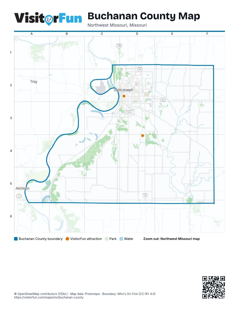
Maps inside Buchanan County
1 map inside, from the street map of Buchanan County down.
Street index of Buchanan County
Each street on the sheet and the grid squares it crosses.
- Sergeant Robert Kimberling Memorial HighwayD2, D3
- Highway 36C2
- Southwest 59 HighwayC3, B4, C4, A5, B5
- North Belt HighwayD1, D2
- Frederick AvenueD2
- Saint Joseph AvenueD1, D2
- South Belt HighwayD2, D3
- South 6th StreetD2, D3
- Lake AvenueC3, D3
- South 9th StreetD2, D3
- Alabama StreetC3
- South 10th StreetD2, D3
- Edmond StreetD2
- Charles StreetD2
- Rochester RoadD1, D2
- Southwest 45 HighwayA5, B5, B6
- Memorial HighwayC3
- North 10th StreetD2
- North 9th StreetD2
- Stockyards ExpresswayC3
- Mason RoadD3
- East Hyde Park AvenueC3, D3
- Utah AvenueA5
- 45 HighwayB6
- Southwest 116 HighwayB5, C5
- Mitchell AvenueD2, E2
- Faraon StreetC2, D2
- South 22nd StreetD2, D3
- Southeast 116 HighwayC5, D5
- South Riverside RoadD2, D3
- Messanie StreetD2
- Southwest U HighwayC3
- North Riverside RoadD2
- Main StreetC2, E4, B5, C5
- Jules StreetC2, D2
- Felix StreetC2, D2
- North Woodbine RoadD2
- King Hill AvenueC3
- Francis StreetC2, D2
- South 40th StreetD2, D3
- Pear StreetD3
- South 36th StreetD2, D3
- North 36th StreetD2
- North 22nd StreetD2
- South 4th StreetD2, D3
- Garfield AvenueD2, D3
- North 3rd StreetD2
- South 3rd StreetD2, D3
- North 4th StreetD2
- North 6th StreetD2
- North 2nd StreetC2
- North Bucklin DriveF3
- Middleton StreetD2
- Walter Welsh AvenueD2
- Southwest JJ HighwayC4, C5
- County Line RoadD1, E1, F5
- Southwest ParkwayD2, D3
- Southeast State Route AD3, D4
- Southwest HH HighwayB5, C5
- Southwest Old Highway RoadB5, B6
- Cook RoadC2, D2
- Southwest KK HighwayB4
- Easton RoadD3, E3
- 45th Road SoutheastD4, D5
- Pickett RoadD3, E3
- Gene Field RoadD2
- Southwest 51st RoadC3
- Southwest North Shore DriveA5, B5
- South 16th StreetD2, D3
- South 14th StreetD2, D3
- Southwest M HighwayB5, B6
- Karnes RoadD2
- Duncan StreetD2
- Olive StreetD2
- Mansfield RoadD3
- Southwest Lower Lake RoadC3
- Monterey StreetD2
- Pacific StreetD2
- Lovers LaneD2
- North Leonard RoadD2
- South 28th StreetD2, D3
- Northwest ParkwayD2
- Miller RoadD1, D2
- South 8th StreetD2, D3
- South 11th StreetD2, D3
- South 50th StreetD2, D3
- Dewey AvenueC2
- Blackwell RoadD1
- Doniphan AvenueD2
- Ashland AvenueD2
- Northeast Woodbine RoadD1, D2
- South 11th Street RoadD3
- North 12th StreetD2
- South 12th StreetD2, D3
- Beck RoadD2
- North Village DriveD1, D2
- Northeast ParkwayD2
- Corporate DriveD2, E2
- North 18th StreetD2
- North 13th StreetD2
- Commercial StreetD3, B5
- Parker RoadC3
- Southwest Lake Crest BoulevardA5, B5, A6
- East Highland AvenueC2, D2
- South 33rd StreetD2, D3
- Savannah RoadD1, D2
- Atchison StreetD3
- Southwest 116th RoadA5
- North 8th StreetD2
- Hickory StreetD2
- North Noyes BoulevardD2
- Highly StreetD2
- North Pointe DriveD1, D2
- Grand DDD5
- North 31st StreetD2
- Grand AvenueD2
- South Woodbine RoadD2
- South 31st StreetD2, D3
- Corby ParkwayD2
- AG Expo WayE2, E3
- Heartland AvenueD2
- North County Line RoadF4
- Southwest 110th RoadA5
- Maple Leaf ParkwayD2
- South Noyes BoulevardD2
- West Highland AvenueC2
- 6th AvenueD2
- Airport RoadC2
- 5th AvenueD2
- Illinois AvenueC3
- Sherman AvenueD2
- Chris Hessler RoadD2
- Crescent DriveD2
- Powell StreetD2
- Parkway A StreetD2
- East Elijah StreetF3
- East Lake BoulevardD3
- East Franklin StreetC2, D2
- Southwest Morrow RoadA5
- Southwest Fowler AvenueA5
- Bluff View DriveC3
- South 49th StreetD3
- Hallar AvenueF4
- West Poulin StreetC2
- Market StreetB5
- Hilltop RoadD2
- West Linn StreetC2
- East Linn StreetC2, D2
- Northwest Parkway Access RoadD2
- Southwest Bluff RoadC3, B4, C4
- Saxton Easton Road SoutheastE3, F3
- 95th Road SoutheastE3, E4, E5
- Southwest Old North RoadB5, C5
- Southwest 66th RoadB4, B5, B6
- 43rd Service Road SoutheastD4, D5, D6
- Southwest Lower Dekalb RoadC4, C5
- 65th Road SoutheastE4, E5, E6
- Halls LeveeA4, B4, B5
- Southwest Crockett RoadC3, B4, C4
- Southwest Contrary Creek RoadB3, C3
- Hurlingen Road NortheastE2, F2
- Southeast Ajax RoadD3
- Southeast 32nd RoadD3, D4
- 90th Road SoutheastE2, E4
- Southeast 140th RoadF3, F4
- Southeast Taos RoadC5, D5
- Southwest Bethel RoadC4
- Southeast Riverside TerraceE3
- Southeast 40th RoadD3, D4
- Cook Road NortheastE2
- 70th Road SoutheastE3, E5
- Southwest 14th RoadC5, C6
- Mitchell Road SoutheastE2
- Bigham Road SoutheastF4
- Lewis School Road SouthwestC4, C5
- Southwest 86th RoadB4
- Southwest Sampson RoadC5
- Southeast 115th RoadF5
- 135th Road NortheastF1, F2
- Southwest 54th RoadC3, B4, C4
- 85th Road NortheastE1, E2
- Malden Creek Road SoutheastE5, F5
- Southwest Taos RoadC5
- Vincent Road SoutheastC5, D5
- 110 NortheastF1, F2
- Southwest Mud Lake RoadA5, B5
- Penn StreetD2
- Pigeon Hill Road SoutheastD4, E4
- Southwest 46th RoadC3, C5, C6
- Waterworks RoadC1, C2
- Seneca StreetD2
- Northeast Hurlingen RoadE2
- 80th Road SoutheastE3, E4, E5
- Southeast Hillyard RoadE3
- Southeast 28th RoadD3, D4, D5
- Hall LeveeA4, B4, B5
- Southeast Mount Moriah RoadF4
- Southwest Martin RoadC6
- 130th Road SoutheastF2, F3, F5
- Huntoon RoadC1, C2
- Northeast Davis RoadE1, F1
- Southwest 20th RoadC5, C6
- Tillery Road SoutheastE4, D5, E5
- 85th Road SoutheastE2, E3
- Lafayette StreetD2
- Southeast 110th RoadF3
- Possum Holler Road SoutheastD4, E4
- Northwest Dupree RoadC2
- Benner Lake Road SoutheastE5
- Southeast 68th RoadE2
- Southeast 135th RoadF4, F5
- Southeast 120th RoadF4, F5, F6
- Southwest Lakefront Lane WestC3
- Sacramento StreetD2
- Southwest Bisel Hill RoadB5
- South 17th StreetD2, D3
- Southwest 95th RoadB4
- South 24th StreetD2, D3
- Sylvanie StreetD2
- Southwest Cotter RoadB4, C4
- Southeast Johnson RoadE4
- 112 SoutheastF2
- Southwest 91st RoadB5
- Southwest Nelson RoadC3
- Kerns Road SoutheastF3
- County CC SoutheastD5, D6
- Campbell Road SoutheastD5, E5
- Southwest 41st RoadC3
- South West 56th RoadB5
- Crabapple Road SoutheastE4, E5, F5
- South 18th StreetD2, D3
- Southeast Moore RoadC3, D3
- Willis RoadC5, D5
- Loutermilch RoadE5
- South Leonard RoadD2, D3
- 60 SouthwestB4, B5
- South 19th StreetD2, D3
- Southeast Seymour RoadD3, D4
- Southeast County Road 125F3
- Southeast Kemmer RoadE3, F3
- South 29th StreetD2, D3
- Angelique StreetD2
- Locust StreetD2, C5
- Hackett RoadD5, D6
- Southeast Turner RoadC3, D3
- Southwest Peck RoadB5
- Southwest 130th RoadA5, A6
- Southwest Lane RoadC4
- Southeast Old Frame RoadE5
- Ruark Road SouthwestC4, C5
- 135th Road SoutheastF2, F3
- Southeast Sparta RoadC4, D4
- 123th Road SoutheastF2
- 50th Road SoutheastD3, D4
- Muddy Creek Road NortheastF2
- South 13th StreetD2, D3
- Moser Road SouthwestC4
- Field RoadB4
- Whitson Road SoutheastE3
- Southeast Auxier RoadF4, F5
- Southwest Jones Sailor RoadC5
- 26 SouthwestC5
- Southwest Warnicks RoadC4
- Jackson StreetD2
- Southeast Mount Zion RoadD3, C4, D4
- Southwest Cottonwood RoadC4
- Southeast 145th RoadF5, F6
- Patee StreetD2
- Old Frame RoadD5, E5
- Walnut StreetC2, D2, D3, C5, D5
- North 2nd Street RoadC2
- North 7th StreetD2
- Dreier Road SouthwestC4
- Southwest Henman RoadB4
- South 15th StreetD2, D3
- Pickett Road SoutheastE3
- 128 SoutheastF3, F4
- Southeast McQueen RoadD4
- Fenton Road SouthwestB5
- Southeast Halleck RoadD5
- Brownell Road SoutheastC4, D4
- South 7th StreetD2, D3
- Sugar Creek Road SouthwestC5
- Southwest Hammy RoadC3
- Douglas StreetD2
- Southwest 31st RoadC5, C6
- South 20th StreetD2, D3
- Hilly Road SoutheastD4, E4
- Southwest Call RoadC4
- 14th Road SoutheastD5, D6
- Spring Holler SoutheastF2
- Southeast 55th RoadD3, D4
- Southeast 11th RoadD5
- Southwest Dittemore RoadC4
- MacArthur DriveC2
- Greenard Road SoutheastE3
- Southeast 144th StreetF2, F3
- Southeast Chestnut RoadE5
- Krug Park DriveD2
- Southwest Janston RoadC3
Things to do on the Buchanan County map
Places on the map
- Agency
- Ashland Cemetery
- Bluffwoods Conservation Area
- Cook Plaza North
- Cook Plaza South
- Corby Grove
- Corby Parkway
- Crockett Family Fun Farm
- De Kalb
- Dupree Memorial Conservation Area
- East Hills Shopping Center
- Easton
- Fairview Golf Course
- French Bottom
- Gosling Lake Trail
- Horseshoe Lake
- Huston Wyeth Park
- Hyde Park
- Krug Park
- Lake Contrary
- Lanowa
- Lewis and Clark State Park
- Lewis and Clark Village
- Maple Leaf Parkway
- Missouri National Guard
- Moila Country Club
- Mosaic Life Care at St. Joseph
- Mount Olivet Cemetery
- Muskrat Lake
- New Mud Lake
- Northeast Parkway
- Northwest Parkway
- Old Mud Lake
- Pigeon Hill Conservation Area
- River Bluff Trails Park
- Riverwalk
- Rushville
- Saint Joseph
- Shoppes at North Village
- Southwest Parkway
Next to Buchanan County
- Atchison
- Troy
© OpenStreetMap contributors, Open Database License, openstreetmap.org/copyright · Map data: Protomaps · Boundary: Who's On First (CC-BY 4.0); Quattroshapes (CC BY 2.0)