

Missouri map
St. Joseph map
About 71,098 people live here (Census Bureau, 2024 estimate). The sheet's index lists 300 streets; Southwest Parkway, Mitchell Avenue and Sergeant Robert Kimberling Memorial Highway cross the most grid squares. Things to do inside the boundary: Glore Psychiatric Museum and Jesse James Home Museum.
Open the map (PDF, US Letter)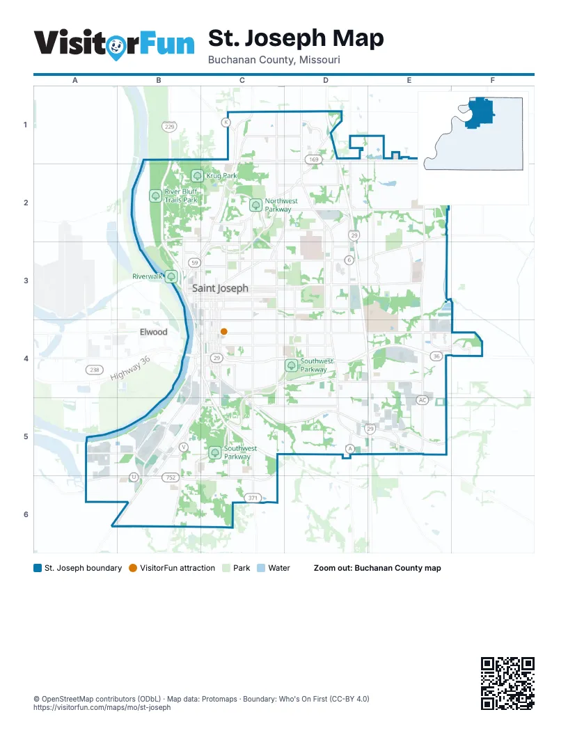
Street index of St. Joseph
Each street on the sheet and the grid squares it crosses.
- Sergeant Robert Kimberling Memorial HighwayD3, D4, E4, E5
- Highway 36B4
- North Belt HighwayD1, D2, D3
- Frederick AvenueE2, C3, D3, E3
- Saint Joseph AvenueC1, C2, B3, C3
- South Belt HighwayD3, D4, D5
- South 6th StreetC3, C4, C5, C6
- Lake AvenueB5, C5, B6
- South 9th StreetC3, C4, C5, C6
- Alabama StreetA6, B6
- South 10th StreetC3, C4, C5, C6
- Edmond StreetB3, C3, D3
- Charles StreetB3, C3, D3
- Rochester RoadD1, D2
- Memorial HighwayB5, A6, B6
- North 10th StreetC2, C3
- North 9th StreetC2, C3
- Stockyards ExpresswayB5, B6
- Mason RoadB6, C6
- East Hyde Park AvenueB6, C6
- Southwest 59 HighwayA6
- Mitchell AvenueB4, C4, D4, E4, F4
- Faraon StreetB3, C3, D3, E3
- South 22nd StreetC3, C4, C5, C6
- South Riverside RoadE3, E4, E5
- Messanie StreetB3, C3, D3, E3
- North Riverside RoadE1, E2, E3
- Jules StreetB3, C3, D3
- Felix StreetB3, C3, D3
- North Woodbine RoadD2, D3
- Francis StreetB3, C3, D3
- Pear StreetC5, D5
- King Hill AvenueB5, B6
- South 36th StreetD3, D4
- North 36th StreetD2, D3
- North 22nd StreetC2, C3
- South 4th StreetB3, B4, B5, B6
- Garfield AvenueC4, C5
- South 40th StreetD3, D4, D5
- North 3rd StreetB2, B3
- South 3rd StreetB3, B4, B5, B6
- North 4th StreetB2, B3
- Main StreetB2, B3
- North 6th StreetC2, C3
- North 2nd StreetB2, B3
- Middleton StreetB3, C3
- Southwest U HighwayA6
- Walter Welsh AvenueC3
- Southwest ParkwayC4, D4, B5, C5, B6, C6
- Cook RoadB1, C1, D1, E1
- Easton RoadC5, D5, E5
- Gene Field RoadC2, D2, E2
- Pickett RoadD4, E4
- South 16th StreetC3, C4, C5, C6
- South 14th StreetC3, C4, C5, C6
- Karnes RoadC2, D2, E2
- Duncan StreetC4, D4
- Olive StreetC4, D4
- Monterey StreetB4, C4, D4
- Pacific StreetC4, D4
- Southwest Lower Lake RoadA5, B5
- Lovers LaneC2, D2, C3
- North Leonard RoadE2, E3
- Mansfield RoadC5, D5
- South 28th StreetC3, C4, C5
- Northwest ParkwayC2, C3
- Miller RoadC1, C2
- South 8th StreetC3, C4, C5, C6
- South 11th StreetC3, C4
- Dewey AvenueB2, B3
- Blackwell RoadC1, D1
- Doniphan AvenueC4, D4
- Ashland AvenueC2, D2, C3
- South 11th Street RoadC4, C5
- North 12th StreetC2, C3
- South 12th StreetC3, C4
- Beck RoadC2, D2
- North Village DriveD1
- Northeast ParkwayC2, D2, C3
- County Line RoadC1, D1
- Corporate DriveE4, F4
- North 18th StreetC2, C3
- North 13th StreetC2, C3
- Parker RoadA6, B6
- Commercial StreetC4, D4
- East Highland AvenueB2, C2
- South 33rd StreetD3, D4, D5
- Savannah RoadC1
- Atchison StreetC4
- North 8th StreetC2, C3
- Hickory StreetB4, C4
- North Noyes BoulevardC3
- Highly StreetC3
- North Pointe DriveD1, E2
- North 31st StreetD1, D2, D3
- Grand AvenueC3
- South Woodbine RoadD3, D4
- South 31st StreetD3, D5
- Northeast Woodbine RoadD1, D2
- Corby ParkwayC3
- Heartland AvenueE3
- Maple Leaf ParkwayB3, C3
- South 50th StreetE3, E4, E5
- South Noyes BoulevardC3, D3, D4
- West Highland AvenueB2, B3
- 6th AvenueC2
- 5th AvenueC2
- Illinois AvenueB5
- Sherman AvenueC3, D3
- Chris Hessler RoadD1, D2
- Crescent DriveC2, C3
- Powell StreetC3
- Parkway A StreetC3, D3
- East Lake BoulevardC5
- East Franklin StreetB3, C3
- Bluff View DriveB5
- South 49th StreetE5
- West Poulin StreetB3
- Hilltop RoadC4, D4
- AG Expo WayF4
- West Linn StreetB3
- East Linn StreetB3
- Northwest Parkway Access RoadC2
- Penn StreetC4, D4
- Seneca StreetB4, C4, D4
- Lafayette StreetC4, D4
- Sacramento StreetB4, C4, D4
- South 17th StreetC3, C4, C5
- South 24th StreetC3, C4, C5, C6
- Huntoon RoadB2, B3
- Sylvanie StreetB3, C3, D3
- South 18th StreetC3, C4, C5
- South Leonard RoadE4, E5
- South 19th StreetC3, C4, C5
- Waterworks RoadB1, B2, B3
- South 29th StreetC3, C4, C5
- Angelique StreetB3, C3, D3
- South 13th StreetC3, C4
- Jackson StreetC4, D4
- Patee StreetB3, C3, D3
- Locust StreetB3, C3, D3
- North 2nd Street RoadB1, B2
- North 7th StreetC2, C3
- South 15th StreetC3, C4, C5
- Southeast Ajax RoadD4, D5
- South 7th StreetC3, C4, C5, C6
- Douglas StreetC2, C3, D3, E3
- South 20th StreetC3, C4
- MacArthur DriveB3
- Krug Park DriveC2
- Downs DriveD3, E3, E4
- South 30th StreetD3, D4, D5
- North 11th StreetC2, C3
- Renick StreetC4, D4
- South 2nd StreetB3, B4, B5, B6
- Walnut StreetB4, C4, D4
- North 17th StreetC2, C3
- Southeast Riverside TerraceE4, E5
- Sherman StreetB5, B6
- Diagonal RoadB5, A6, B6
- North 20th StreetC2, C3
- South 26th StreetC3, C4, C5
- South 21st StreetC3, C4
- North 26th StreetC2, C3
- East Walter LaneB6, C6
- North 25th StreetC2, C3
- South 27th StreetC3, C4
- Meadow Ridge DriveC6
- Bishop RoadE1, E2
- Stonecrest TerraceD3, E3
- Pryor AvenueB5, B6
- North 29th StreetC2, D2, C3
- South 35th StreetD3, D4, D5
- Buckingham StreetD2, D3
- Oak StreetB4, C4, D4
- Carnegie StreetB5, B6
- Safari DriveE2, E3
- South 39th StreetD3, D4
- Belle StreetC4
- Green Valley RoadC1
- Mary StreetC3
- Mulberry StreetC3, D3
- North 24th StreetC3
- North 15th StreetC2, C3
- Pleasant AvenueC5, C6
- Clay StreetC3
- South 38th StreetD3, D4
- South 34th StreetD3, D4, D5
- South 32nd StreetD3, D4
- North 16th StreetC2, C3
- North 19th StreetC3
- North 5th StreetB2, B3, C3
- South 25th StreetC3, C4, C6
- Elizabeth StreetB6
- Oakland AvenueC2, D2, D3
- South 1st StreetB5, B6
- Scott StreetC4, D4
- Washington StreetB6
- South 42nd StreetD4, D5
- Grant StreetB5, B6
- Cedar StreetB4, C4
- Greystone DriveD1, E1
- Union StreetC3
- Outer RoadE4
- South 5th StreetC3, C4, C5, C6
- South 40th TerraceD4, D5
- North 32nd StreetD2, D3
- Northeast College DriveE3, E4
- West Joseph StreetB6
- Pettis RoadD5
- Ingersoll RoadA5, A6
- Prospect AvenueB2, B3
- Northridge DriveC1, D1
- Rock Springs RoadC1
- West Valley StreetB6
- Sycamore StreetC4
- Corinth DriveE1, E2
- Hadley DriveD3
- Holman StreetC3
- North 27th StreetC2, C3
- Green Acre RoadD1
- South 23rd StreetC3, C4
- Harmon StreetB5, C5
- Village DriveD2, D3
- Riverview DriveC5
- Green StreetB2, C2
- North Lakewood DriveE2
- Eastwood DriveE3
- Mockingbird LaneE3
- Amazonia RoadC1, C2
- Beechwood BoulevardE4
- Gordon AvenueB5, B6
- Crystal DriveE4
- Randolph StreetC2
- Empire LaneC5
- South Lakewood DriveE2
- Stonecrest DriveD3, E3
- North 3rd Street RoadB2
- Tucker StreetB6
- North 23rd StreetC3
- Highland MeadowsC2
- Kensington DriveE1, D2, E2
- Jones StreetC3
- King Hill DriveB5, C5
- University AvenueE4
- North 30th StreetD1, D2, D3
- Robidoux StreetB3, C3
- Maxwell RoadC1, C2
- Phillip StreetB6, C6
- Beattie StreetC3
- Chellew RoadB2
- Excello DriveC5
- Brown StreetB6
- Berkshire DriveD2
- Garden StreetC5
- Burnside AvenueC2
- Gooding AvenueC5
- Court StreetC5
- Lincoln StreetC3
- Marie StreetB6
- South 41st StreetD4
- Lion RoadE2
- Ollmeda StreetB6
- Colhoun StreetC3
- Meadow TrailE4
- Industrial RoadA5, A6
- Savannah AvenueC2, B3
- Jimtown RoadC1
- North Creekwood DriveE5
- East Florence RoadB5
- Miller AvenueD2
- Corby StreetC3
- Eureka StreetB6
- Eastowne DriveE4
- Agency RoadC4
- Woodfield DriveE3
- Elwood StreetB3
- Tamara DriveE2, E3
- Countryside LaneC5
- Newport RoadC2
- South 48th TerraceE5
- Paseo DriveC5
- Hamburg StreetB2, C2
- Virginia StreetB5
- Ferndale AvenueC2
- Moss StreetC2
- Pat DriveE2, E3
- Commonwealth DriveD5
- Ridenbaugh StreetC3
- Woodson StreetB3, C3
- West Ayr Lawn DriveC5
- Greenbriar TerraceE3
- East Cliff StreetB6, C6
- East Colorado AvenueB5, C5
- Valley LaneE4
- McNeely DriveD3
- Oscar StreetC1
- Providence Hill DriveE5
- Dale AvenueD2
- West Market StreetB3
Things to do on the St. Joseph map
Places on the map
- Ashland Cemetery
- Bartlett Park
- Benton High School
- Bishop LeBlond High School
- Bode Middle School
- Carden Park Elementary School
- Carriage Square
- Central High School
- Coleman Elementary School
- Comeback Loop
- Cook Crossings
- Cook Plaza North
- Cook Plaza South
- Corby Dog Park
- Corby Grove
- Corby Parkway
- Corby Pond
- Drake Park
- Driving Range
- East Hills Shopping Center
- Fairview Golf Course
- Huston Wyeth Park
- Hyde Park
- Krug Park
- Maple Leaf Parkway
- Missouri National Guard
- Moila Country Club
- Mosaic Life Care at St. Joseph
- Mount Olivet Cemetery
- Northeast Parkway
- Northside Complex
- Northwest Parkway
- River Bluff Trails Park
- Riverwalk
- Rushin Prairie Trail
- Saint Joseph
- Saint Joseph Memorial Park
- Shoppes at North Village
- Southwest Parkway
- Urgent Care
Next to St. Joseph
- Elwood
© OpenStreetMap contributors, Open Database License, openstreetmap.org/copyright · Map data: Protomaps · Boundary: Who's On First (CC-BY 4.0); U.S. Census Bureau