

Missouri map
Camden County map
About 44,135 people live here (Census Bureau, 2024 estimate). The sheet's index lists 300 streets; Sunset Drive, Osage Beach Parkway and Main Street cross the most grid squares. Things to do inside the boundary: Ha Ha Tonka State Park and Lake of the Ozarks State Park.
Open the map (PDF, US Letter)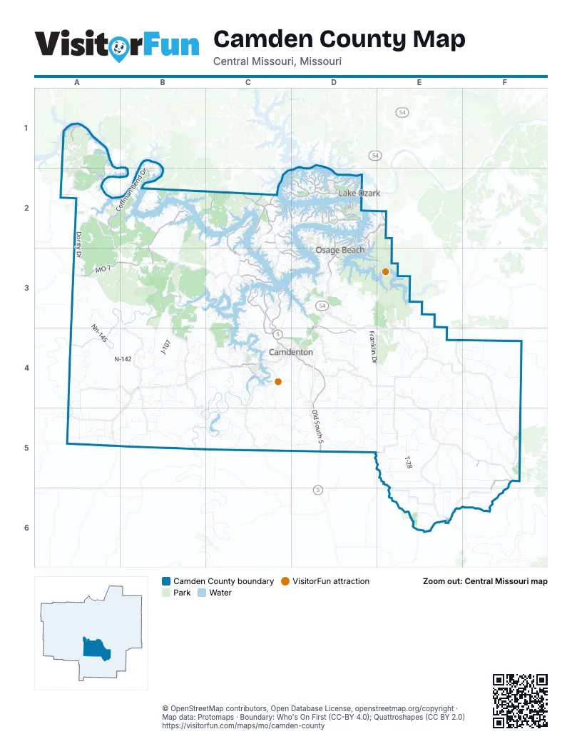
Street index of Camden County
Each street on the sheet and the grid squares it crosses.
- Police Officer Phylicia Carson Memorial BridgeD2
- Osage Beach ParkwayD2, E2, D3
- Old South 5D4, D5
- Horseshoe Bend ParkwayC2, D2
- MO 7A3, B3
- N State Highway 5C2
- North Business Route 5C4
- South Business Route 5C4, D4
- Lake of the Ozarks Community BridgeD2
- Hurricane Deck BridgeC3
- West Washington AvenueF5
- South Main StreetC2
- Galena RoadF5, F6
- Bagnell Dam BoulevardD2
- 1st StreetE6
- Jeffries RoadD2
- Main StreetD3, B4, E6
- Hillhouse RoadF5
- South Locust StreetD3, D4
- Camden County Line RoadD5, E5
- Oak StreetA2, E6
- Church StreetE6
- 2nd StreetE6
- Coffman Bend DriveA2, B2
- Bollinger Creek RoadB2, B3
- Sellers RoadC2, C3
- Old Route 5C3, C4
- Pier Thirty One RoadC3, C4
- Business Park RoadD3, D4
- Brown Bend RoadA1, A2
- Twin River PointC3
- Country Club DriveD2, C4
- Bittersweet RoadC2, D2
- Standing Rock RoadC3
- Nichols RoadD2, D3
- Passover RoadD2, D3, E3
- Singing Oaks DriveC2
- Bear Paw RoadC3
- Spring Creek DriveD2, F5
- Villages WayD2
- Spring Cove RoadC2
- Old Fifty Four RoadC4
- Chimney PointD2
- Cherokee RoadD2
- Carol RoadD2
- St Croix DriveC3, D3
- State Highway RAC2
- Duckhead RoadD2
- Muirfield DriveD2
- Shawnee Bend RoadD2
- Sagrada RoadA1
- Pisces DriveC2, D2
- Ridge CircleD2
- Dogwood RoadD2
- Cozy Cove RoadC3, D3
- Beachwood DriveC2
- Grand Point BoulevardD2
- Spruce LaneD2
- Dude Ranch RoadD2
- Las CampanasD2
- Harvest RoadC3
- Point Lookout RoadC2, D2
- Cornett Branch RoadD2
- Indian Hill RoadC2
- Linn Creek RoadD2
- American Legion DriveC2
- Bear Paw Cut-ThruC3
- Rockdale DriveC2
- Case RoadD2, D3
- Malibu RoadD3
- Shawnee Bend One (MM-16)D2
- Kays Point RoadD2
- West Valley DriveD3, D4
- Shawnee Four DriveD2
- Shawnee Four Drive (MM-40G)D2
- East Valley DriveD3
- Barry Prewitt Memorial DriveE2
- Climax AvenueA3
- Chimney Point (MM-22)D2
- Rockdale RoadC2
- Bass Point RoadC2
- High Point RdD4, D5, E5
- Spencer Creek RoadC4, C5, D5
- Anderson Hollow RoadD3, E3
- Mount Horeb RoadC5, D5
- Nn-145A3, A4
- Franklin DriveD3, D4, E4
- Carroll Cave RdE4, E5
- Snellings LaneD4, E4, D5
- Shepherd RoadE5, F5
- Knob Hollow RoadA3, B3
- McCubbins DriveE3, E4
- Mountview RoadF4, F5
- Camden Line RdD5
- Chapel Bluff Rd (54-98)B4, B5
- Tunnel Dam RoadB5, C5
- Seven Springs RdE5, F5
- Dority DriveA2, A3
- Adkins RoadB2
- Mailhack RoadB4
- Stoutland Creek Rd (T-23)E5, E6
- Dry Hollow RoadC4, D4
- Chapel Bluff RoadB4, B5, C5
- Doc Ridgeway DriveB4, C4
- Big Island RoadB3, C3
- West Branch Rd (73-124)A5
- Cable RidgeA2
- Ozark Isle DriveC4
- Longar RdE5
- Freedom Ridge RoadE4
- Chelsie RoadC2
- Purvis RoadC2
- Lower Prairie Hollow RoadB3, C3, B4
- Granger LaneB3
- Sharp RdE4
- Wilson Bend RoadB2
- Cross Creek DriveD3, D4
- Solitary DriveB3, B4
- Neongwah Bend RoadC4
- N-142A4, B4
- Wagon Trail DriveC4
- Great Lakeview DriveC2
- Lowell Williams RoadD4
- Four Corners Rd (H-128)E5, F5
- Eaton Avenue (7-120)E5
- Irontown DriveB2, B3
- Lick Creek RoadA1
- Black Oak Rd (A-77)F4
- Outpost RoadD2, E2, E3
- Tranquil Woods RoadC2, B3, C3
- Possum Hollow DriveC3, C4
- J-107B4
- Traw Hollow RdE5
- Jefferies RoadE4
- Anderson Rd (A-100)F4, F5
- Valley Crest RdC5, D5
- Fairview RoadF5
- Broads Branch RoadB4, B5
- Dodds Camp RoadA2, B2
- Robin Hood LaneB2
- Sweatt Rd (7-42)D4
- Black Locust Rd (A-77A)F4
- Knight RoadE5
- Baranowski DrE5
- Cape Woods DriveD3
- Willow Creek RoadD4
- Cup Tree RoadB2
- Swinging Bridges RdE3, E4
- Keepsake RoadE6
- Black RoadD3, E3
- Melody LaneD2, D3
- Rogers Ave (H-116)E6
- Geronimo Springs RoadA4, A5
- Sunny Slope DriveC4
- Thunder Mountain RoadC4
- Waldren DriveC5
- Bluff DriveB2, D2, E2
- Post Office RoadC4, C5
- Firey Fork RoadA3, B3
- Silver Springs DriveB3, C3, D3
- Bear RoadF4, F5
- Darby Hollow RoadC4, C5
- Upper Prairie Hollow Road (N-100)B4
- Grand View DriveD2
- T-28E5
- Alcorn Hollow RoadB2, C2
- Whitworth RoadB4, C4
- New Woodbridge RoadD4
- Mel Dor Acres DriveB2
- OLD MORGAN RDC4
- N-142 HA4
- Twelve Corners (C-36D)E4, F4
- Hemple RoadB5, C5
- El Terra RoadD3
- Wolf Pen HollowB3, C3
- Lakeshore DriveD2, C4
- Oak Valley DrD3
- Ball Park RoadC4
- Everly LoopC2
- Susan RoadD2
- Resorts RoadC3
- Mill School Rd (73-120)A5, B5
- Wet Glaize RdE4
- Alta DriveB2
- Mill Creek RdE4
- Piney Point DriveC4
- Arrowridge DriveB2
- Upper Prairie Hollow Rd (J-100)B4
- Palisades DriveD2
- Via Appia DriveD2
- Eaton Avenue (H-120)E5, E6, F6
- Deans Creek Rd (C-38)E4, F4
- St Moritz DriveD3
- Avalon WayB2
- Cliff House DriveA2
- Sweetwater DriveC2, D2
- Pine Cove RoadA2
- East Branch Rd (O-133)B5
- Ha Ha Tonka RoadC4
- Goldie Bend RoadC4, C5
- Oak Bend DriveC3, D3
- Kirkland Ridge RoadC5
- Big Island View DriveC3
- Camp Hohn DriveB2, C2
- Garman Hollow RdE5
- Buckingham DriveC3
- 7-23 HA3
- Baydy Peak RoadD2
- Midway DriveD3
- Sawmill Cove RoadA1
- Northwest Shockley RoadA1
- Point Happy DriveC3, D3
- North N-125A3
- Brownsville Rd (T-35)E5
- Stoner Green RoadB3
- Sunset DriveC2, D2, E2, C3, C4
- Velvet Antler RoadC3
- Casper RdB5
- Whistle RoadB4, B5
- Shawnee View DriveC2, D2
- Boot DriveC3
- N-107B4
- Windwood Shores DriveA2, B2
- Triple Cove LaneB2
- Spring Valley RoadD3, F4
- 54-98MB5
- Matson LaneD3
- N Davis Hollow RdE4
- East Branch Rd (73-133)A5, B5
- N-150B4
- Ginger RoadD2
- Bluejay RoadB1, B2
- Camelot DriveC3
- Thousand Acres RdD3
- Mud Hole Rd (0110)B4
- Mill School Rd (O-120)B5
- Toronto DrE4
- Hazel Valley DriveB4
- Three Seasons RoadD2, D3
- Mistwood Bluff RoadC2, C3
- Davison RoadB4, C4
- Opportunity RoadD4
- Happy Hollow DrE4
- Upper Prairie Hollow RoadB4
- Oak Bend RoadC3, D3
- Redbud LaneB2, D2
- Maritime LaneC3
- Stoutland Creek Rd (H-112)E6
- Crystal Springs RoadD3
- Ozark Fisheries RoadE5
- Cottonwood Branch (H-142)F5
- Lynch Dr (54-146)A5
- Moira RoadA1
- Lake Road Ff-14 RoadA2
- Dry Ridge RoadD4
- Pleasant Knoll Rd (H-130)F5
- Old Kinderhook DriveC4
- Olney CircleE3
- Woodland HillB2
- Parkers PointA2, D2
- Valliant LaneC5
- N-166 RA4
- Twin Valley LoopD3
- Valley RoadC2, D2
- Hollywood DriveA1
- Cedar Ridge CircleB3, C3
- Central Ozarks RoadA1
- Yacht Club DriveD2
- Rainwater RdE4
- Pleasant Valley DriveB2
- Crater Hill RoadD4
- Elliott Drive (54-99)B4
- Simons PointB2
- Winery Hills EstatesD3
- Nautica RoadC3
- Garmon Hollow RdE5
- Tranquil PointC3
- Timber Ridge RoadC2, C3
- Lakeview DriveC3, C4
- Public Beach RoadD3
- Good Neighbors LaneC4
- Lake Road Ff-6A2
- Secluded Woods DriveC3
- Brookhaven LaneD2
- Michaels RoadA1, A2
- Long Shore CircleA1
- Genes Point RoadC3
- Koehler DriveC3, C4
- Thrush RoadC2
- Garrison RoadD4, E4
- Prater Homestead RoadC5
- Bannister Hollow RoadA3, A4, B4
- Airport RoadD3
- Lazy Days RoadD3
- Cyrus DriveB4
- Cocamo Ridge LoopC4
- H-53E6
- Indian Park RoadC3
- Glover Dr (C-36A)F4
- Old Nonsuch RoadB3
Things to do on the Camden County map
Places on the map
- Camden on the Lake Resort
- Camdenton
- Camdenton City Park
- Camdenton High School
- Camdenton Memorial Airport
- Camp Hohn
- Center for Behavioral Health – Osage Beach
- Climax Springs
- Deer Valley Park
- Fiery Fork Conservation Area
- Good Oak Lake
- Ha Ha Tonka State Park
- Honey Run Trail - South Loop
- Lake Niangua
- Lake of the Ozarks
- Lake of the Ozarks State Park
- Lake Regional Health System
- Lake Trail
- Lake Valley Golf Club
- Larry R. Gale Access
- Linn Creek
- Linn Creek-Grand Glaize Memorial Airport
- Lynch Hollow Cove
- Macks Creek
- Missouri Trap Shooters Shooting Range
- Moles Cave Conservation Area
- Montreal
- Old Kinderhook Resort, Golf, Club & Spa
- Osage Beach
- Osage Beach City Park
- Osage Beach Premium Outlets
- Port of Indecision Marina
- Rocky Top Trail
- Stoutland
- Sunrise Beach
- Sycamore Creek Golf Club
- The Club at Porto Cima
- The Oaks
- The Ridge
- Village of Four Seasons
© OpenStreetMap contributors, Open Database License, openstreetmap.org/copyright · Map data: Protomaps · Boundary: Who's On First (CC-BY 4.0); Quattroshapes (CC BY 2.0)















