

Missouri map
Columbia map
About 130,900 people live here (Census Bureau, 2024 estimate). The sheet's index lists 300 streets; Dwight D. Eisenhower Highway, Paris Road and Range Line Street cross the most grid squares. Also on it: 3M Wetlands Cell Three, A. L. Gustin Golf Course and A. Perry Philips Park.
Open the map (PDF, US Letter)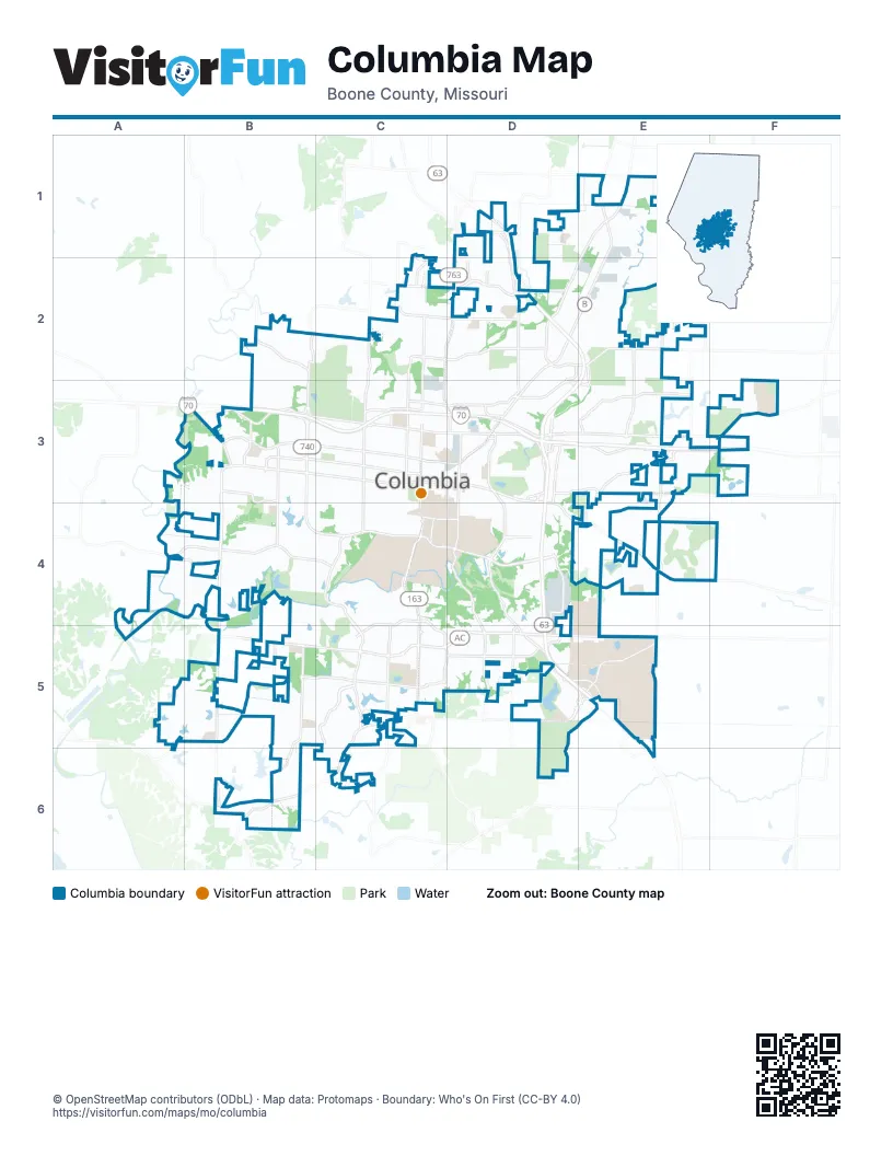
Street index of Columbia
Each street on the sheet and the grid squares it crosses.
- Dwight D. Eisenhower HighwayB3, C3, D3, E3, F3
- Sheriff Roger I. Wilson Memorial HighwayD3
- Highway Patrol Sgt. Benjamin Booth Memorial HighwayC3, D3
- U.S. Submarine Veterans' Memorial HighwayB3
- South Providence RoadC3, C4, C5
- Paris RoadE1, D2, E2, D3
- Range Line StreetC2, D2, C3, D3
- North Stadium BoulevardB2, B3
- West BroadwayB3, C3
- East Stadium BoulevardC4, D4
- Grindstone ParkwayC5, D5
- East Nifong BoulevardC5, D5
- North Providence RoadC1, C2, C3
- East BroadwayC3, D3, D4
- Business Loop 70 EastC3, D3
- South Stadium BoulevardB3, B4, C4
- Business Loop 70 WestB3, C3
- Conley RoadD3
- US 63/I-70 ConnecterD3
- New Haven AvenueD5
- Scott BoulevardB3, B4, B5, B6
- South Rolling Hills RoadE3, E4, E5, E6
- Clark LaneD3, E3
- Vandiver DriveE2, C3, D3, E3
- Saint Charles RoadD3, E3, F3
- Old 63 SouthD3, D4, D5
- West Nifong BoulevardB5, C5
- Discovery ParkwayD5, E5
- East Brown School RoadC2, D2
- North Ballenger LaneE2, E3
- South College AvenueD3, D4
- Old 63 NorthD3
- Hoylake DriveE4
- West Vawter School RoadB5
- East Prathersville RoadD1
- North College StreetD3
- West Boulevard NorthC3
- West Boulevard SouthC3, C4
- North Grace LaneE3
- North Oakland Gravel RoadD1, D2
- Interstate 70 Drive SouthwestC3
- Wales DriveB3
- Bearfield RoadD5
- Forum BoulevardC4, C5
- Brown Station RoadE1, D2, E2
- Blue Ridge RoadC2, D2
- West Worley StreetB3, C3
- Interstate 70 Drive SoutheastD3, E3, F3
- Chapel Hill RoadA4, B4, C4
- Rollins RoadB3, C3, B4, C4
- I- 70 Drive SouthwestB3, C3
- South Rock Quarry RoadD4, D5
- Mexico Gravel RoadD2, E2
- West Ash StreetB3, C3
- North Garth AvenueC2, C3
- Southampton DriveB5, C5
- East Richland RoadE3, F3
- South Sinclair RoadB5, B6
- Highlands ParkwayC5
- North Creasy Springs RoadC2, C3
- South Fairview RoadB3, B4
- Derby Ridge DriveD2
- Bethel StreetC5
- Maguire BoulevardD4
- Oakland Gravel RoadD2, D3
- East Gans RoadD5, E5
- West Old Plank RoadC5, C6
- Interstate 70 Drive NorthwestB3
- South Ponderosa StreetD5, E5
- East Green Meadows RoadC4, C5
- South Bearfield RoadD5
- East Smiley LaneD2
- Roger I Wilson Memorial DriveD1, D2
- East New Haven RoadD5, E5
- Buttonwood DriveC4, C5
- West Smiley LaneC2, D2
- West Gillespie Bridge RoadA4, B4
- Geyser BoulevardE3
- North Strawn RoadB3
- Parker StreetD2, D3
- South Lenoir StreetD5, E5
- Hitt StreetD3, D4
- Ponderosa StreetD5
- Lemone Industrial BoulevardD4, D5
- North Fairview RoadB3
- Sinclair RoadB5
- West Green Meadows RoadC4, C5
- Parkade BoulevardC3
- North Keene StreetD3
- East Ash StreetC3, D3
- Silvey StreetB3
- Shepard BoulevardD4
- Hanover BoulevardE3
- West Texas AvenueC3
- Blackfoot RoadB2
- Lenoir StreetD5
- Old Plank Road SouthB6
- Rogers StreetC3, D3
- South 5th StreetC3, C4
- State Farm ParkwayC5, D5
- Heriford RoadD3
- Parkside DriveB2, C3
- Tiger AvenueC4
- Rollins StreetC4, D4
- South Old Mill Creek RoadB5
- Woodard DriveD2, D3
- North Wyatt LaneE2
- Rice RoadE3
- Veterans United DriveC5
- Trimble RoadD3
- East Starke AvenueD2
- Edenton BoulevardD2
- North Lake of the Woods RoadE3
- Park de Ville DriveB3
- Bull Run DriveE3
- Broadfield DriveB3
- East Rollins StreetD4
- East Texas AvenueC3
- East Mexico Gravel RoadE2
- East Leslie LaneC3
- Ammonette StreetD3
- East Worley StreetC3
- Hill Creek RoadC6
- South Keene StreetD3, D4
- Brickton RoadD3
- North Brown Station RoadE1
- South Bethel Church RoadC5
- East Old Plank RoadC5
- Fairview RoadB3
- North Hinkson Creek RoadE2
- Old Hawthorne Drive EastE4, F4
- East Walnut StreetC3, D3
- East Sugar Grove RoadD5, E5
- Bernadette DriveB3, C3
- Old Route KC4
- Thornbrook ParkwayA5, B5
- Broadway Village DriveD3, D4
- Nocona ParkwayD5
- Grant LaneB4
- Waco RoadD1, E1
- North Rogers RoadE1, E2
- Outer RoadC4, C5
- Crabapple LaneB5
- Mick Deaver Memorial DriveC4
- Louisville DriveB3, A4, B4
- Stone Mountain ParkwayE4
- Brundage RoadE1
- East Heller RoadE1
- Northland DriveC2, D2
- Cascades DriveB6
- Bluff Creek DriveD4, D5
- West Stewart RoadC3
- Ashland RoadD4
- Wilkes BoulevardC3, D3
- Clinkscales RoadC3
- University AvenueC4, D4
- Bourn AvenueB3, B4
- Steeplechase DriveA5, B5
- Lynnwood DriveC4, C5
- West Smith DriveA3, B3
- South Gans Creek RoadD5, E5, D6
- South Rustic RoadD4
- Rain Forest ParkwayC2, D2
- Park AvenueC3, D3
- Faurot DriveB3
- North Cedar Lake Drive WestC5
- Bass Pro DriveD3
- Timberhill RoadD4
- Hulen DriveB3, B4
- Defoe DriveB3
- Proctor DriveC2, C3
- North 8th StreetC3, D3
- Katy LaneB4, C4
- Maplewood DriveC3, C4
- Clydesdale DriveC2
- North 7th StreetC3
- East Campus LoopD4
- Jackson StreetC3
- South Glenwood AvenueC3, C4
- Limerick LaneB4, C4
- Westwinds DriveC4
- Garden DriveB2, B3
- Thornbrook RidgeA5, B5
- RidgemontB4, C4
- Snow Leopard DriveC2
- Churchill DriveB3, D5
- Royal Lytham DriveC5
- Champions DriveC4
- South Greenwood AvenueC3, C4
- Newbury WayA5, B5
- West Sexton RoadC3
- Edgewood AvenueC3, C4
- South Farm DriveD5, E5
- Carter LaneC4
- North William StreetD3
- Shore Acres LoopE4
- College Park DriveB4, C4
- Timber Run DriveB6
- Doris DriveC3
- Green Valley DriveD3, D4
- McBaine AvenueC3
- Gray Oak DriveC5, D5
- Chambray RoadB4
- Prestwick DriveC5
- Rose DriveB2, B3
- Mills DriveC4
- Cliff DriveD3, D4
- Battle AvenueF3
- Locust StreetC3, D3
- Rees Ln.E2
- Audubon DriveD4
- McKee StreetE3
- Agronomy Research DriveC4
- Glen Eagle DriveC5
- Sunset DriveC4, D5
- Ridgefield RoadB4
- South High Point LaneB6
- Copperstone Creek DriveB5
- Barberry AvenueB3
- South William StreetD3, D4
- Rainbow Trout DriveB4
- Cinnamon Hill LaneD4
- Hardin StreetC3
- Pershing RoadC3
- Bluff BoulevardD4
- Iris DriveB2, B3
- Sawgrass DriveB5
- Hinkson AvenueD3
- Monterey DriveC5
- Gypsy Moth DriveD2, D3
- Nelwood DriveD2, D3
- Park de Ville PlaceB3
- Big Bear BoulevardC2, C3, D3
- North Ann StreetD3
- Stonington DriveB5
- Jewell AvenueC3
- Bear Creek DriveC2, C3
- Whitegate DriveD3
- Woodrail AvenueC4
- Arbor Pointe ParkwayD1, E1
- Crestland AvenueC3, C4
- Saint ChristopherC4
- Maupin RoadC3
- Fay StreetD3
- Braemore RoadB3
- Hirth AvenueC3
- Rothwell DriveB3
- Virginia AvenueC4, D4
- Carrie Francke DriveC4
- Ridgeway AvenueC3
- Berrywood DriveD3, E3
- West Old Field RoadB5
- Sylvan LaneD3
- Sunflower StreetB2, B3
- Godfrey DriveC5
- Holly AvenueD3
- Grand AvenueC3
- Lansing AvenueD3, E3
- Reedsport RidgeB3
- Spring Valley RoadC3, C4
- Westridge DriveC3, C4
- Light Post DriveE4
- Bray AvenueB4
- East Campus DriveD4
- Screaming Eagle DriveE4
- Gasconade DriveE3
- Bristol Lake ParkwayD5
- Stonehaven RoadC5
- Sondra AvenueC3
- Longfellow LaneB3, C3
- Primrose DriveB2, B3
- Darlington DriveB5
- Corona RoadB4
- Kunlun DriveB3
- Cunningham RoadB4
- Manor DriveC3, C4
- South 9th StreetC3, C4
- Snowberry CircleD4
- Anderson AvenueC3
- Danforth DriveD4
- Russell BoulevardC3, C4
- Westwood AvenueC3, C4
- Endeavor AvenueD5, E5
- Port WayE3
- South Woods Edge RoadB4, B5
- Random RidgeE4
- Forsythia Falls LoopB5
- Aaron DriveB3
- Columbia Gorge ParkwayE4
- Jake LaneB4
- Lake Valley LaneC5
- North Masonic DriveD1
- Oak Lawn DriveC4, C5
- Thompson RoadE2
- Juniper PlaceD5
- Red Bay Greek RoadB5
- South University LaneE5
- Sudbury DriveC5
- Country Club DriveD3
- South 6th StreetC3, C4
Places on the map
- 3M Wetlands Cell Three
- A. L. Gustin Golf Course
- A. Perry Philips Park
- Albert-Oakland Park
- Antimi Sports Complex
- Atkins Ballfields
- Battle Park
- Bonnie View Nature Sanctuary
- Boone County Fire Training
- Broadway Business Park
- Capen Park
- Cedar Lake
- Colonies
- Columbia Country Club
- Columbia Mall
- Columbia Pride Soccer Complex
- Columbia Sanitary Landfill
- Columbia School District
- Cosmo Fitness Trail
- Cosmo Park
- Country Club of Missouri
- Eastport Park
- Epple Field
- Fairview Marketplace
- Flat Branch
- Forum Nature Area
- Forum Shopping Center
- Gans Creek Cross Country Course
- Gans Creek Recreation Area
- Garth Nature Area
- Government District
- Grindstone Nature Area
- Grindstone Plaza
- Hinkson Outdoor Complex
- Hinkson Woods Conservation Area
- John W. Alspaugh Park
- Perimeter Trail
- Phillips Lake Trail
- Strawn Park
- The Club at Old Hawthorne
© OpenStreetMap contributors, Open Database License, openstreetmap.org/copyright · Map data: Protomaps · Boundary: Who's On First (CC-BY 4.0); U.S. Census Bureau