

Missouri map
Boone County map
About 192,154 people live here (Census Bureau, 2024 estimate). The sheet's index lists 300 streets; East Broadway, Dwight D. Eisenhower Highway and South Providence Road cross the most grid squares. Things to do inside the boundary: Columbia, Katy Trail State Park and Rock Bridge Memorial State Park.
Open the map (PDF, US Letter)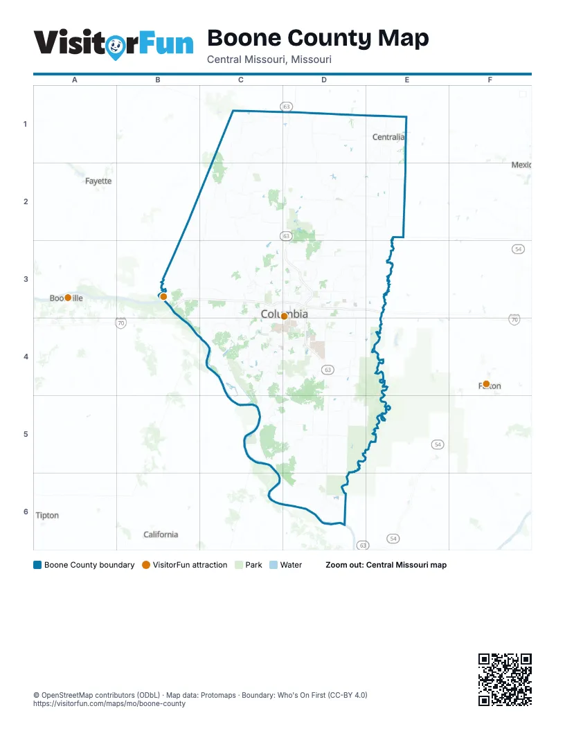
Maps inside Boone County
1 map inside, from the street map of Boone County down.
Street index of Boone County
Each street on the sheet and the grid squares it crosses.
- Dwight D. Eisenhower HighwayC3, D3, E3
- U.S. Submarine Veterans' Memorial HighwayB3, C3
- Sheriff Roger I. Wilson Memorial HighwayD3
- Highway Patrol Sgt. Benjamin Booth Memorial HighwayC3, D3
- South Providence RoadD3, C4, D4
- Paris RoadD3
- Range Line StreetD3
- East Highway 124D2
- West BroadwayC3, D5
- North Stadium BoulevardC3
- East Stadium BoulevardD4
- East BroadwayC3, D3, D4, D5
- Grindstone ParkwayD4
- East Nifong BoulevardC4, D4
- North Providence RoadD3
- Business Loop 70 EastC3, D3
- South Stadium BoulevardC3, C4, D4
- Business Loop 70 WestC3
- Conley RoadD3
- East Sexton StreetC2
- US 63/I-70 ConnecterD3
- New Haven AvenueD4
- West Sexton StreetC2
- Sexton StreetC2
- Saint Charles RoadD3, E3
- Scott BoulevardC3, C4
- South Rolling Hills RoadD3, D4
- North Oakland Gravel RoadD3
- Clark LaneD3
- Vandiver DriveD3
- Old 63 SouthD3, D4
- East Brown School RoadC3, D3
- West Nifong BoulevardC4
- Discovery ParkwayD4
- South College AvenueD3, D4, D5
- North Ballenger LaneD3
- East Prathersville RoadD3
- West Vawter School RoadC4
- Old 63 NorthD3
- Hoylake DriveD4
- South Jefferson StreetE1
- North College StreetD3, D5
- West Boulevard NorthC3
- West Boulevard SouthC3, C4
- Rowland RoadC2
- North Jefferson StreetE1
- North Grace LaneD3
- South Harris StreetC2
- Interstate 70 Drive SouthwestC3
- Wales DriveC3
- Bearfield RoadD4
- South Rangeline RoadD3, D4, D5
- Mexico Gravel RoadD3, E3
- Interstate 70 Drive SoutheastD3, E3
- Old US 63D1, D2
- North Highway VvC2, C3, D3
- North Creasy Springs RoadC3
- South Rock Quarry RoadD4
- East New Haven RoadD4
- West Akeman Bridge RoadC3
- Forum BoulevardC4
- East Richland RoadD3
- Brown Station RoadD3
- East Old State Highway 124D2, E2
- Blue Ridge RoadC3, D3
- West Worley StreetC3
- I- 70 Drive SouthwestC3
- Chapel Hill RoadC4
- East Kemper RoadD2
- East Oakland Church RoadD3
- Jay JayE1, E2
- Rollins RoadC3, D3, C4
- Old Plank Road SouthC4
- East Mount Hope RoadD3, E3
- Old US Highway 40D3, E3
- North Wagon Trail RoadD3
- East Zumwalt RoadD6
- North Brown Station RoadD2, D3
- South Mount Pleasant RoadD6
- West Gillespie Bridge RoadC4
- West Ash StreetC3
- North Kircher RoadD3
- East Calvert Hill RoadD3
- South Sinclair RoadC4
- North Dripping Springs RoadC2
- North Garth AvenueC3, D3
- Southampton DriveC4, D4
- Interstate 70 Drive NorthwestC3
- South Ponderosa StreetD4
- South Bearfield RoadD4
- North Liddell LaneD3
- East Ketterer RoadD3
- West Dripping Springs RoadC2
- North Rangeline RoadE1, D3
- North Wade School RoadC3
- Highlands ParkwayC4
- East Gans RoadD4
- East McGee RoadD2, D3
- South Airport RoadD5
- Old Highway 63 SouthD5, D6
- West Old Plank RoadC4
- South Fairview RoadC3, C4
- West Benedict RoadC2, D3
- Derby Ridge DriveD3
- North Lake of the Woods RoadD3
- Bethel StreetC4
- West High Point LaneC4
- Hill Creek RoadC4
- North Wyatt LaneD3
- Trimble RoadC2, D3
- North Boatman Hill RoadD2, D3
- East High Point LaneC4, D4
- Maguire BoulevardD4
- South Tom Bass RoadD4
- Oakland Gravel RoadD3
- South Smith Hatchery RoadC4
- South Old Mill Creek RoadC4
- East Angel LaneD5
- Henry Clay BoulevardD5
- East Green Meadows RoadC4, D4
- East Smiley LaneD3
- Roby Farm RoadB3
- Roger I Wilson Memorial DriveD3
- West Obermiller RoadC3
- North Strawn RoadC3
- S Old Highway 63 SD5
- Blackfoot RoadC3
- Buttonwood DriveD4
- West Smiley LaneC3, D3
- Geyser BoulevardD3
- North Frink RoadD2
- West Red Rock RoadC2
- Parker StreetD3
- South Lenoir StreetD4
- Gano Chance RoadE1
- Hitt StreetD3, D4
- West Mauller RoadC3
- North Silver Fork Hill RoadC2
- Ponderosa StreetD4
- Lemone Industrial BoulevardD4
- North Fairview RoadC3
- Sinclair RoadC4
- West Green Meadows RoadC4
- Parkade BoulevardC3
- East Alfalfa DriveD3
- North Mount Pleasant RoadD6
- North Keene StreetD3
- East Ash StreetC3, D3
- North Clearview RoadC3
- West Lakeview AvenueE1
- Silvey StreetC3
- Shepard BoulevardD4
- Hanover BoulevardD3
- East Meyer Industrial DriveD4
- West Texas AvenueC3
- East Starke AvenueD3
- East Lakeview AvenueE1
- South Bethel Church RoadC4
- South Ogden StreetD1
- North Allen StreetE1
- Lenoir StreetD4
- East Mauller RoadC3, D3
- Rogers StreetD3
- Fair Grounds AvenueD1
- South 5th StreetD3, D4
- Rollins StreetD1, D4
- State Farm ParkwayD4
- Heriford RoadD3
- Parkside DriveC3
- West Brown School RoadC3
- Tiger AvenueD4
- Woodard DriveD3
- East Dripping Springs RoadC2, D2
- West Singleton StreetE1
- Hackberry BoulevardC3, D3
- South Henry Clay BoulevardD5
- East Hinton RoadC3, D3
- East Arnold LaneD5
- North Howard Burton DriveE1
- Rice RoadD3
- East Old Plank RoadC4, D4
- Veterans United DriveD4
- East Mexico Gravel RoadD3
- Old US Highway 63 SouthD5
- East Switzler StreetE1
- Edenton BoulevardD3
- Lakeview AvenueE1, D3
- Park de Ville DriveC3
- Bull Run DriveD3
- 3rd StreetB3
- Wall StreetD1
- North Ogden StreetD1
- Broadfield DriveC3
- East Rollins StreetD4
- East Texas AvenueC3, D3
- East Leslie LaneC3, D3
- Ammonette StreetD3
- East Worley StreetC3, D3
- North 2nd StreetD3, D6
- Sare StreetC4
- East Stone StreetD1
- East Singleton StreetE1
- South Keene StreetD3, D4
- Brickton RoadD3, D4
- SarrC4
- North Audrain StreetD1
- Mount Hope RoadD3
- Fairview RoadC3, C4
- County Road 276E3
- East Broadway21D5
- South River RoadC5, C6, D6
- North Old Number 7C2
- North Boothe LaneC2, C3
- East Mount Zion Church RoadD2, E2
- South Clinkenbeard RoadD5, E5
- North Tucker School RoadD1, D2
- East Hartsburg Bottom RoadD6
- West Wilhite RoadC2, C3
- East Nashville Church RoadC5, D5
- North Barnes RoadD1, D2
- North O'Neal RoadC3
- North Locust Grove Church RoadC3
- East Pinnacles RoadD2
- North McDonald RoadE2
- March RoadE1
- South Coats LaneC4
- South Bob Veach RoadD5
- East Vemers Ford RoadD4, E4
- South Jemerson Creek RoadD5, D6
- East Cedar Tree LaneC5, D5
- East Fox Hollow RoadC5, D5
- East Owens School RoadD2, E2
- Davenport RoadE2
- Stidham RoadC2
- South Ben Williams RoadD4
- North Bell RoadC2, C3
- West Sweringen RoadC2
- West Botner RoadC2
- West Williams RoadC1, C2, D2
- East Christian School RoadD5, D6
- North Rocheport Gravel RoadB3
- West Hatton Chapel RoadC3
- Sturgeon Cemetery RoadD1
- Woodie ProctorC4, C5
- South Purdy LaneE3, E4
- East Friendship Church RoadD2
- East Spiva Crossing RoadD3
- East Bonne Femme Church RoadD4
- North Hinkson Creek RoadD3
- East Liberty LaneD5
- Johnson Cemetery RoadE5
- South Andrew Sapp RoadC5, D5
- South Olivet RoadD3, D4
- East Keil RoadD1
- North Rogers RoadD3
- East Deer Park RoadD4
- Union Church RoadE1
- East Benson RoadD1
- Dinwiddie School RoadD1
- West Wehmeyer RoadC3
- East Englewood RoadD5, E5
- East Turner Farm RoadD4
- East Judy School RoadD3, E3
- East Claysville RoadD6
- North Perche Church RoadC1, C2
- North Oak Grove School RoadC2
- Old Hawthorne Drive EastD4
- South Westbrook DriveD6
- North Ponderosa RoadC1
- East Gilmore LaneD5, D6
- South Myers LaneD5
- Tucker School RoadD1, D2
- Star School RoadC4
- East New Salem LaneD5
- East O'Rear RoadD3
- South Nebo Cemetery RoadC4
- West Harper RoadC1, D1
- East Maupin LaneE3
- Roberts LaneE2
- Bethlehem RoadC2
- East Walnut StreetC3, D3
- East Calvin DriveC5, D5
- North Barnett School RoadC1, C2
- North Willet RoadD2
- East Low Crossings RoadD2
- North Davis RoadD2, E2
- Kroeger RoadE2
- South Ginn LaneE4, E5
- East David Allen RoadD4, E4
- West Willis RoadC2
- East Biggs RoadD5
- South Hawkins RoadD5
- Harper RoadC1
- Smith Hatchery RoadC4, C5
- Arrowhead Lake DriveC4
- North Robinson RoadD2
- Thomas Hill RoadD1, D2
- East Log Providence RoadD4, D5
- East Bass LaneD4
- North Glendale DriveE3
Things to do on the Boone County map
Places on the map
- A. L. Gustin Golf Course
- A. Perry Philips Park
- Arrowhead Lake
- Ashland
- Bo Co Mo Lake
- Boone County Fairgrounds
- Boone County Nature School
- Centralia
- Columbia
- Columbia Country Club
- Columbia Sanitary Landfill
- Columbia Township
- Cosmo Park
- Country Club of Missouri
- Eagle Knoll Golf Club
- Finger Lake
- Finger Lakes State Park
- Forum Nature Area
- Gans Creek Recreation Area
- Grindstone Nature Area
- Hallsville
- Harrisburg
- Hart Creek Conservation Area
- High Ridge Trail
- John W. Alspaugh Park
- Lake Champetra
- Lick Creek Conservation Area
- McBaine
- Midway Golf and Games
- Perimeter Trail
- Phillips Lake Trail
- Pierpont
- Rocheport
- Rock Bridge Memorial State Park
- Rocky Fork Lake
- Rocky Fork Lakes Conservation Area
- Scott Blvd Farm
- Strawn Park
- Sturgeon
- Three Creeks Conservation Area
Next to Boone County
- Boonville
- California
- Fayette
- Fulton
- Mexico
- Tipton
© OpenStreetMap contributors, Open Database License, openstreetmap.org/copyright · Map data: Protomaps · Boundary: Who's On First (CC-BY 4.0); Quattroshapes (CC BY 2.0)