

Missouri map
Fulton map
About 12,573 people live here (Census Bureau, 2024 estimate). The sheet's index lists 299 streets; North Bluff Street, Richland Heights Road and Westminster Avenue cross the most grid squares. Things to do inside the boundary: America's National Churchill Museum.
Open the map (PDF, US Letter)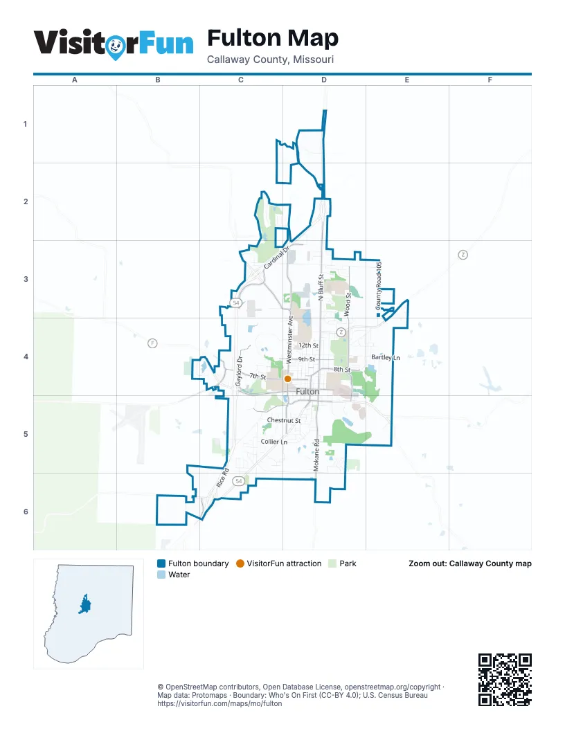
Street index of Fulton
Each street on the sheet and the grid squares it crosses.
- County Road 110D1
- County Road 114D1
- County Road 209D1
- County Road 210D1
- Nicklaus CourtC2
- Palmer CourtC2
- Tanglewood WayC2, D2
- Backer DriveD2
- County Road 200D2
- County Road 201D2
- Dogwood DriveD2, D3
- Dudley CourtD2
- Haymart LaneD2
- Hilltop DriveD2
- Hogan CourtD2
- Mitchell LaneD2
- North Bluff StreetD2, D3, D4
- Peacock DriveD2, D3
- Richland Heights RoadD2, C3, D3
- Atkinson RoadC3
- Birch Cove DriveC3
- Cardinal DriveC3, D3
- County Road 204C3
- County Route 202C3
- Dunham DriveC3, D3
- Fairway DriveC3
- Golf DriveC3
- Log Cabin LaneC3
- West Saint Eunice RoadC3, D3
- William Woods AvenueC3, D3
- 12th StreetD3, D4
- Ashley CourtD3, D4
- Canterbury DriveD3
- Christopher LaneD3
- Dawson PlaceD3
- Dawson StreetD3
- Douglas BoulevardD3, D4
- Downing CourtD3
- East Industrial RoadD3
- East Saint Eunice RoadD3, E3
- Essex DriveD3
- Gates BoulevardD3
- Glover StreetD3
- Hornet DriveD3
- Industrial RoadD3
- Knollwood RoadD3, D4
- Law CourtD3
- Manor DriveD3
- McNeal LaneD3
- Meadowlark LaneD3
- Miller DriveD3
- North School BoulevardD3, D4
- Plaza DriveD3, D4
- Porter PlaceD3
- Power LaneD3
- Rock CircleD3
- Sabre CircleD3
- Tree CircleD3
- West Industrial RoadD3
- Westminster AvenueD3, D4, D5
- Wood StreetD3, D4, D5
- County Road 105E3, E4
- Haddley Lee DriveE3, E4
- Lake DriveE3, E4
- Lakeview DriveE3
- Hawk Lake DriveB4, C4
- Airway DriveC4
- Amerihost DriveC4
- Brookside DriveC4
- Brown StreetC4
- Carver DriveC4, D4
- County Road 302C4, C5
- County Road 304C4
- Crestwood DriveC4, D4
- Elm StreetC4
- Gaylord DriveC4
- Hackberry StreetC4
- Hickman AvenueC4
- Hollyhock DriveC4
- Martin Luther King Junior DriveC4, D4, C5
- Mc Intire StreetC4
- North Hospital DriveC4, C5
- Parkview AvenueC4
- Stack RoadC4
- Stonemill DriveC4
- Sycamore StreetC4, D4, C5
- Thatcher StreetC4
- Vernon AvenueC4
- Walker LaneC4
- West 13th StreetC4, D4
- West 7th StreetC4, D4
- West 8th StreetC4, D4
- West 9th StreetC4, D4
- Westover AvenueC4
- Westview DriveC4
- Woodhill AvenueC4
- 11th PlaceD4
- 8th AvenueD4
- Amherst StreetD4
- Anthony StreetD4
- Bartley LaneD4, E4
- Biggs Access RoadD4, D5
- Bluff StreetD4, D5
- Bradley LaneD4, E4
- C F Lampkin DriveD4
- Cedarwood DriveD4
- Center StreetD4
- Church StreetD4
- Circle DriveD4
- Country Club DriveD4
- Court StreetD4, D5
- Donna LaneD4, E4
- Dyer StreetD4
- East 10th StreetD4
- East 12th StreetD4
- East 13th StreetD4
- East 14th StreetD4
- East 4th StreetD4
- East 5th StreetD4
- East 6th StreetD4
- East 7th StreetD4
- East 8th StreetD4
- East 9th StreetD4
- East AvenueD4
- East Walnut StreetD4
- Evergreen DriveD4
- Ewing AvenueD4
- Forest AvenueD4
- Grand AvenueD4
- Grand StreetD4
- Green StreetD4
- Gross PlaceD4
- Halley CourtD4
- Helen Stephens LaneD4
- High StreetD4
- Highland AvenueD4
- Hillcrest StreetD4
- Hollywood BoulevardD4
- Ivy LaneD4
- Jefferson StreetD4, D5
- Kay DriveD4
- Kleewood DriveD4
- La Clerc CourtD4
- Lynn StreetD4
- Market StreetD4, D5
- Middle StreetD4
- Monroe StreetD4
- Morningside DriveD4, E4
- Nichols StreetD4, D5
- North Ravine StreetD4, D5
- Northeast 8th StreetD4
- NW StreetD4
- Oak StreetD4, D5
- Park AvenueD4
- Park DriveD4
- Penn AvenueD4
- Pioneer DriveD4, D5
- Poston AvenueD4
- Richard Ault DriveD4
- Saint Louis AvenueD4
- Saint Louis RoadD4, E4
- Saint Michael StreetD4
- Saults AdditionD4
- Sexton DriveD4
- State StreetD4, D5
- Sunset DriveD4
- Tucker LaneD4
- University AvenueD4
- Vine StreetD4
- Walnut StreetD4, D5
- West 10th StreetD4
- West 11th StreetD4
- West 12th StreetD4
- West 14th StreetD4
- West 15th StreetD4
- West 4th StreetD4
- West 5th StreetD4
- West 6th StreetD4
- West AvenueD4
- West Walnut StreetD4
- Westwood BoulevardD4
- Woodlawn AvenueD4
- Apache DriveE4
- Castlewood AvenueE4
- Cherokee LaneE4
- Chippewa DriveE4
- East Morningside DriveE4
- Helm StreetE4
- Kathy StreetE4
- Lane StreetE4
- Mohawk DriveE4
- Osage LaneE4
- Panda DriveE4
- Perry LaneE4
- Raye StreetE4
- Sioux DriveE4
- Thrush StreetE4
- West Morningside DriveE4
- Aidens WayC5
- Arrow StreetC5
- Ashton Circle EastC5
- Ashton Circle WestC5
- Boulder CourtC5
- Callaway DriveC5
- Churchill RoadC5
- Claymine DriveC5
- Collier LaneC5, D5
- Colonial DriveC5
- Common Loop LaneC5, D5
- Commons DriveC5, D5
- Cote Sans Dessein RoadC5
- County Road 306C5
- County Road 401C5, C6
- Dale StreetC5
- Dixie AvenueC5
- Ferdinand DriveC5
- Gary StreetC5
- Glenstone DriveC5
- Granite CourtC5
- Greystone VillageC5
- Herring DriveC5
- Ingle RoadC5, D5
- Jamestown DriveC5
- Julian LaneC5
- Kenwood DriveC5
- Kingswood DriveC5, C6
- Kinleigh DriveC5
- Marbrooke DriveC5
- Old Jefferson City RoadC5
- Parkridge DriveC5, C6
- Penny LaneC5
- Preston DriveC5
- Randall LaneC5
- Rice RoadC5, C6
- Rosedale StreetC5
- Sign Painter RoadC5, D5
- Singer LaneC5
- South Hospital DriveC5
- Spruce DriveC5
- Tennyson RoadC5, D5, D6
- Truman RoadC5
- West Chestnut StreetC5, D5
- Addalynn DriveD5
- Addison StreetD5
- AllenD5
- Ann StreetD5
- Blackburn StreetD5
- Briar Wood TrailD5
- Cleveland AvenueD5
- Clinic Drive SouthD5
- Devona StreetD5
- Disposal Plant RoadD5
- East 1st StreetD5
- East 2nd StreetD5
- East 3rd StreetD5
- East Chestnut StreetD5
- East Oliver StreetD5
- East Reed StreetD5
- East WhitlowD5
- Erik PlaceD5, D6
- Gregory LaneD5, D6
- Hawthorn StreetD5
- Heather StreetD5
- Hockaday AvenueD5
- Jessica LaneD5
- Kenneth LaneD5
- King StreetD5
- Laurel PlaceD5
- Lee StreetD5
- Locust LaneD5
- Lyle StreetD5
- Lynn AvenueD5
- Matthew StreetD5
- Meadow Ridge CircleD5, D6
- Merklin DriveD5
- Mokane RoadD5, D6
- Natalie CourtD5
- Oak AvenueD5
- Palmer StreetD5
- Saint Francis StreetD5
- Schultz StreetD5
- Sheri LaneD5
- Smith StreetD5
- South Ravine StreetD5
- South Westminster AvenueD5
- South Westminster DriveD5
- Steidemann StreetD5
- Tyler StreetD5
- Washington StreetD5
- West 2nd StreetD5
- West 3rd StreetD5
- West Oliver StreetD5
- West Reed StreetD5
- West WhitlowD5
- Williams StreetD5
- Worsham CircleD5
- Youth Center DriveE5
- Silver DriveC6
- County Road 409D6
Things to do on the Fulton map
Places on the map
- Amerihost Inn & Suites
- Auto World Museum
- B&B Fulton Cinema
- Backer Sports Complex
- Baymont Fulton
- Blue Jay Field
- BreakTime
- Bush Elementary School
- Butler Family Sorority Circle
- Callaway County Public Library
- Callaway County Sheriff’s Office
- Callaway Memorial Gardens
- Casey's
- Church Of Saint Mary Aldermanbury
- Davidson Leadership Plaza
- Debo
- Dollar General
- Dulany Auditorium
- Dulany Library
- Elder Tennis Courts
- Equestrian Cross Country Course
- Fulton Country Club
- Fulton High School
- Fulton Reception and Diagnostic Center
- Fulton State Hospital
- Guhleman Forensic Center
- Hauck Lake
- Hearnes Forensic Center
- Hillcrest Cemetery
- Junior Lake
- Missouri School for the Deaf
- Morningside Lake
- Saint Peters School
- Tanglewood Golf Course
- Truman Lake
- Veterans Park
- William Woods University
© OpenStreetMap contributors, Open Database License, openstreetmap.org/copyright · Map data: Protomaps · Boundary: Who's On First (CC-BY 4.0); U.S. Census Bureau















