

Missouri map
Callaway County map
About 45,126 people live here (Census Bureau, 2024 estimate). The sheet's index lists 300 streets; Dwight D. Eisenhower Highway, Old US Highway 40 and Jade Road cross the most grid squares. Things to do inside the boundary: America's National Churchill Museum.
Open the map (PDF, US Letter)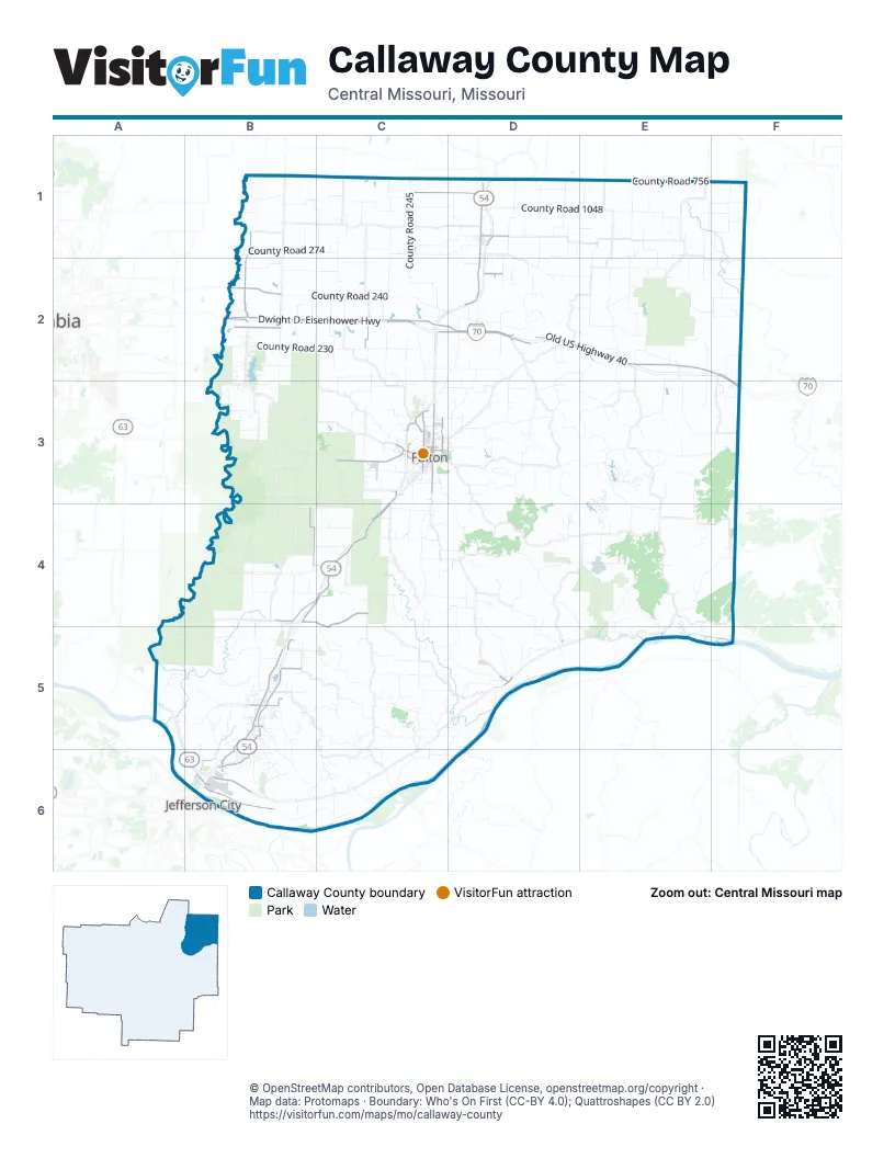
Maps inside Callaway County
1 map inside, from the street map of Callaway County down.
Street index of Callaway County
Each street on the sheet and the grid squares it crosses.
- Dwight D. Eisenhower HighwayB2, C2, D2, E2, F2, F3
- North Bluff StreetC3
- Market StreetC3, E5
- Saint Louis AvenueC3
- Mokane RoadC3, B6
- South Summit DriveB5, B6
- County Road 1030E2
- Bluff RoadB6
- East Simon BoulevardB5
- East Harrison StreetD1, E1
- Redwood DriveB4
- Martin Luther King Junior DriveC3
- Bluff StreetC3, D5
- Nelson AvenueD5
- Fulton AvenueD5
- East 2nd StreetC3
- West 4th StreetC3
- East 4th StreetC3
- Old US Highway 40B2, C2, D2, E2, F2, F3
- Old US Highway 54D1, D2, B4, C4, B5
- Jade RoadB2, C2, D2, E2, F2, F3
- County Road 269B1, B2
- County Road 2002C1, D1
- County Road 436B4, C4, C5
- County Road 304C3
- Halifax RoadB5, B6
- County Road 337B4
- Platinum RoadB4, C4, B5
- Outer RoadD1, B5, B6
- County Road 276B2
- Westminster AvenueC3
- County Road 256B2
- Wood StreetC3
- Silver DriveC3, C4
- West 7th StreetC3
- Cardinal DriveC3
- County Road 223C2
- County Road 158D2
- County Road 498B5
- Gaylord DriveC3
- Center StreetC3, B5
- William Woods AvenueC3
- Cedar City DriveB6
- East 8th StreetC3
- Sign Painter RoadC3
- North Summit DriveB5
- West Simon BoulevardB5
- South Main StreetD1
- West 9th StreetC3
- Karen AvenueB5
- East 5th StreetC3
- East 9th StreetC3
- Karen DriveB5
- West 2nd StreetC3
- West 5th StreetC3
- County Route 147D2
- South Westminster AvenueC3
- Airway DriveC3
- Airport RoadB6
- South Westminster DriveC3
- County Road 240B2, C2
- County Road 448E4
- County Road 363B4
- County Road 445D4, D5
- County Road 1048D1, E1
- County Road 134D3, E3
- County Road 480C5, D5
- County Road 391B5, B6
- County Road 274B1, C1
- County Road 4031B5, B6
- County Road 4010C6
- County Road 428D4, E4
- County Road 245C1, C2
- County Road 184E2
- County Road 756E1, F1
- County Road 325C3, C4
- County Road 183E1, E2
- County Road 156D2
- County Road 170E3, F3
- County Road 263C1, C2
- County Road 230B2, C2
- County Road 4055E4, F4
- County Road 409C3, D3, D4
- County Road 1051E1, E2
- County Road 4038B6, C6
- County Road 452B5, C5
- County Road 397A5, B5
- County Road 405C4
- County Road 459E4, E5
- County Road 133D3, D4, E4
- County Road 177E2, E3, F3
- County Road 305C3, C4
- County Road 113D3
- County Road 260C1, D1
- County Road 220C2
- County Road 155E3, E4
- County Road 257B2, B3
- County Road 189D1
- County Road 282C1
- County Road 371B4, B5
- County Road 227C2, C3
- County Road 455D4, D5
- County Road 447D4, D5
- County Road 1053F1, F2
- County Road 228B2, B3, C3
- County Road 262C1, D1
- County Road 315C3
- County Road 4037B5, B6
- County Road 231C1, C2
- County Road 485C5, C6
- County Road 246B2, C2, B3
- County Road 210C2, C3
- County Road 292B1, C1
- County Road 980B1, C1
- County Road 456C5
- County Road 132D3, E3
- County Road 166D2, E2
- County Road 148D2
- County Road 1006E2
- County Road 469E4, E5
- County Road 441C4, C5
- County Road 116C3, D3
- County Road 318B4, C4
- County Road 154D2, E2
- County Road 4000C5, D5, C6, D6
- County Road 457D4, E4, E5
- County Road 334B3, C3
- County Road 135E3
- County Road 163E2
- County Road 299B1
- County Road 121C2, D2, C3
- County Road 403C4
- County Road 215C2, C3
- County Road 1022E2, F2
- County Road 338B4, C4
- County Road 468E4, E5
- County Road 382B5
- County Road 102D3
- County Route 347B4
- County Road 1067E1
- County Road 111D3, D4
- County Road 105D3
- County Road 161E2, E3
- County Road 266B2, C2
- County Road 440C5
- County Road 1044E1
- County Road 225C2
- County Road 470D5
- County Road 435C4, C5
- County Road 484C5
- County Road 328B4, C4
- County Road 123D3
- Deer Run RoadE3
- County Road 438C4, D4
- County Road 106D3
- County Road 354B3
- County Road 488B5, C5
- County Road 373B4, B5
- Erfie DriveD3
- County Road 283B1, C1
- County Road 217C2, C3
- County Road 486C5
- County Route 172E2, E3
- County Road 1003E2
- Big Tavern Creek RoadE4, F4
- County Road 407C4
- County Road 4006C5
- County Road 1017D1, E1
- Audrain Road 980C1
- County Road 108D3
- County Road 389A4, B4, B5
- County Road 1002E2
- County Road 117D2
- County Road 118D2
- County Road 207C3
- County Road 4057E4
- County Road 280C1, D1
- County Road 115D2, D3
- County Road 349B4
- County Road 398A5, B5
- County Road 1034F2
- County Road 323B3
- County Road 326B3, C3
- County Road 351B3
- County Road 193F3, F4
- County Road 404C4
- County Road 1027E1, E2
- County Road 4039B6
- County Road 216C2
- County Road 284B2
- County Road 1033F2
- County Road 356B4
- County Road 191E3, E4
- Renz Farm RoadA5, A6, B6
- County Route 419D4
- County Road 185E2
- County Route 324B3, C3
- County Road 306C3
- County Road 453D5
- County Road 101D3
- Baker TrailB5
- County Road 433C4
- Richland Heights RoadC3
- County Road 449D4
- County Road 197E2, E3
- County Road 1054E1, F1
- County Road 4040B6
- County Road 372B5
- County Road 4021B6, C6
- County Road 277C1
- County Road 346B3
- County Road 451D4
- County Road 229C3
- County Road 169D1, D2
- County Road 281C1, F3
- County Road 361B4
- Tennyson RoadC3
- County Road 856D1
- County Road 343B3
- County Road 136D3
- County Road 471C5
- Wildwood Estates DriveE4
- County Road 138D3, E3
- County Road 271D1
- County Road 367B5
- Woodwind WayB5
- County Road 143D2
- Amanda DriveD1, D2
- County Road 165D1, D2
- County Road 425D4
- County Road 353B3
- County Road 181E2
- County Road 388B4
- County Road 4034B5, B6
- County Road 487C5
- County Road 1066D1
- County Road 424D4
- Smith RoadB1
- Red BudD3
- County Road 152E4
- County Road 1042E1, F1
- Bartley LaneC3, D3
- County Road 1043E1
- County Road 401C3, C4
- County Road 1069D1
- County Road 458D5
- County Road 1045D1
- County Road 364B4
- County Road 4003C5, C6
- County Road 253B2
- County Road 254C2
- County Route 202C3
- County Road 1019D1
- County Road 1011E1, E2
- County Road 474C5, D5
- County Route 127D2
- County Road 394A5
- O'Keefe Ridge RoadE3
- County Road 213C2
- County Road 4011C5, C6
- County Road 235B2
- County Route 255B2
- County Road 1037E1, E2
- Harrison Creek DriveD2
- County Road 430C4
- County Road 144E2
- County Road 219C3
- County Road 218C3
- County Road 4012B5
- County Road 140D2
- County Road 293B1
- County Road 129D3
- County Road 1052E1, F1
- Hudson RoadB4
- County Road 348B4, C4
- County Road 182E2
- County Road 249C2
- Thatcher DriveF3
- County Road 131D4
- County Road 142E2
- County Road 410C4
- County Road 247C2
- County Road 1015D1
- County Road 342B3
- County Road 125D3
- County Road 432C4
- County Road 396B5
- County Road 251B2
- County Road 264C1
- County Road 285B1
- County Road 233C2
- Barrows RoadC5
- Oilwell RoadB6
- County Route 107D2, D3
- Lost Canyon Lake DriveE3, E4
- County Road 139D2, D3
- Lakeside DriveE1
- La Forest LaneE3
- Tecumseh TrailE2
- County Road 362B4
Things to do on the Callaway County map
Places on the map
- 63 Diamonds Sports Complex
- Auxvasse
- Baker Lake
- Baumgartner Lake
- Big Lake
- Canyon Lake
- Cedar Creek Resort & RV Park
- Davis Lake
- Doctor Vaughn Lake
- Dogwood Acres Lake
- Earthquake Hollow Conservation Area
- Ed Whalen Lake
- Elton Hensley Memorial Airport
- Eugene Hooks Lake
- Fulton
- Fulton Country Club
- Fulton High School
- Fulton State Hospital
- Gasper's
- Glover Spring Lake
- Gurwit and Lewis Lake
- Guthrie Lake
- Holts Summit
- Holts Summit Greenway Park
- John Gasper Lake
- Junior Lake
- Kingdom City
- Kirchoff Lake
- Lake Lochaweeno
- Lake Mykee
- Lake Mykee Town
- Little Dixie Lake
- Little Dixie Lake Conservation Area
- Meadow Lake Acres Country Club
- Mokane
- New Bloomfield
- Railwood Golf Club
- Reform Conservation Area
- Tanglewood Golf Course
- Whetstone Creek Conservation Area
Next to Callaway County
© OpenStreetMap contributors, Open Database License, openstreetmap.org/copyright · Map data: Protomaps · Boundary: Who's On First (CC-BY 4.0); Quattroshapes (CC BY 2.0)















