

Missouri map
Jackson map
About 15,929 people live here (Census Bureau, 2024 estimate). The sheet's index lists 300 streets; East Jackson Boulevard, Bainbridge Road and Old Cape Road cross the most grid squares. Also on it: Bent Creek Golf Club, Jackson City Park and Kimbeland Country Club.
Open the map (PDF, US Letter)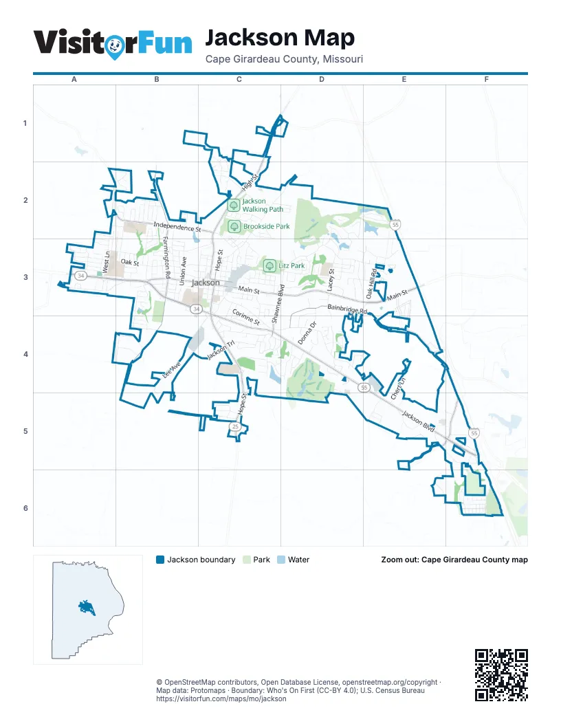
Street index of Jackson
Each street on the sheet and the grid squares it crosses.
- East Jackson BoulevardC3, C4, D4, E4, E5, F5
- West Jackson BoulevardA3, B3, C3
- North High StreetC1, C2, C3
- South Hope StreetC3, C4, C5
- North Hope StreetC3
- East Washington StreetC3
- East Main StreetC3, D3, E3
- West Main StreetB3, C3
- La Salle AvenueE3
- Bainbridge RoadD3, E3, D4, E4
- South Farmington RoadB3, B4
- North Farmington RoadB2, B3
- West Independence StreetB2, C2
- South Old Orchard RoadF4, E5, F5
- South Shawnee BoulevardC3, D3, C4
- County Road 306E4
- Old Cape RoadC3, C4, D4, E4
- Ridge RoadD3, E3
- Oak StreetA3, B3
- Greensferry RoadC2, D2, C3
- Lee AvenueC3, B4, C4, B5
- Old Cape Road EastE5, F5, F6
- Jackson TrailB4, C4
- Old Toll RoadA3, B3
- Highland DriveC4, D4
- Woodland DriveC3, D3
- West Adams StreetB3, C3
- Oak Hill RoadD3, E3
- Jackson Ridge DriveB3, B4
- Watson DriveD2, E2
- East Adams StreetC3
- Ramsey Branch BoulevardF6
- Morgan StreetB2, B3
- West Washington StreetB3, C3
- North West LaneA2, A3
- Donna DriveD3, D4
- Kimbel LaneD4
- Parkview StreetB3, C3
- Mulberry StreetD3
- Stotler WayD3
- Green Meadows DriveD3, E3
- Whetstone WayA3
- Broadridge DriveB2, B3
- North Lacey StreetD3
- Corinne StreetC3, C4
- Otto DriveD3, D4
- Wedgewood DriveD2, D3
- North Union AvenueB3
- West Deerwood DriveC2
- Old Cape Road CircleE5
- West Jefferson StreetB3, C3
- East Jefferson StreetC3
- Francis DriveC2
- Diana StreetD3
- Connie DriveB2, B3
- Prairie View TrailC1, C2
- Strawberry LaneB2, B3
- Easton DriveC4
- Orchard DriveA3, B3
- Elwanda DriveB3
- Dogwood AvenueB4
- Goodson DriveC2
- Deerwood Drive WestC2
- BroadridgeB2
- North Maryland StreetC3
- Pioneer Orchard RoadA3
- County Road 435C1
- Travelers WayD3
- Cherokee StreetC4, D4
- North Georgia AvenueC3
- Trail Ridge DriveD4
- Lexington StreetF6
- North Missouri StreetC3
- North Ohio StreetC3
- North Russell StreetC3
- Seabaugh RoadB4
- Brittany DriveE5
- Alpine StreetA2, B2
- Cathy DriveB3
- East LaneB3
- Pinedale DriveF6
- Mansfield PlaceD3
- South Missouri StreetC3
- Jonathan DriveA3
- Gerald StreetC4
- August StreetC3
- East Independence StreetC2, C3
- Morton StreetC3
- Odus DriveC3
- County Road 330B4
- Litz BoulevardD2, D3
- East Monroe StreetC3
- South Oklahoma StreetB3
- Warren Lake DriveC4, D4
- Kimbel Woods DriveD4
- Shady LaneC4
- Clark StreetC2
- Eagle DriveD3
- North Shawnee BoulevardD3
- Spring Lake TrailE2
- Grandview DriveC5
- Breckenridge DriveD3, E3
- Kies AvenueC3, C4
- Bent Creek DriveD2, D3
- Elm StreetB3
- Boxwood DriveB2
- Flatrock TraceF6
- Greenway DriveD4
- Lapierre RoadC3
- Hidden Meadow DriveD3
- Timber LaneC5
- Lenco AvenueB4
- Rosebud DriveB2
- Chert LaneE4, E5
- Lakeshore DriveD3
- Emma StreetC3
- Daisy AvenueB3
- Donna Lynn DriveC2, D2
- Ridgeway DriveD3
- Deerwood DriveC2, D2
- South Union AvenueB3
- TanglewoodB2
- Cortland DriveA3
- Hilltop DriveD4
- Eastview CourtC3
- Columbia DriveB4
- Dallas StreetB3
- Brown StreetB3
- Mohawk StreetC4
- County Road 307E4, F4
- Aspen DriveA2, A3
- West Mary StreetB3, C3
- Aaron DriveB2, A3
- Lakewoods DriveD2, D3
- County Road 313F6
- Canyon TrailC2
- Pecan LaneB2, B3
- Smith TrailD4
- Boehme LaneC4
- Howard StreetC3
- Birdie LaneD3
- South Georgia StreetC3
- Elmwood BoulevardB3
- Brandom StreetC3
- Kimbeland DriveD4
- Old Hickory DriveD4
- Bainridge RoadE3, E4
- Greenleaf AvenueB2
- Jennifer DriveC2, D2
- Clear Spring PlaceC1, C2
- Vera Wagner DriveC3, D3
- Bramblewood DriveB2
- South High StreetC3
- North Bast StreetB3
- Pawnee AvenueC4
- Railroad Access RoadC3
- Cambridge RoadB2
- Michael Anna StreetC3, C4
- Barks StreetB2
- North Donald StreetC3
- Nancy DriveC4
- Old Poplar RoadE3
- Colorado StreetB3
- Rolling Fields DriveB3
- Vail DriveE3
- Olive StreetC2, C3
- Terrace Park PlaceC2
- Bel-Air DriveC3, C4, D4
- Birk LaneF5
- Saint Andrews DriveD2
- Sioux AvenueC4
- Cedar StreetD3
- Bristol DriveA3
- Indian ParkwayB2
- Berkley DriveA2, A3
- North StreetC3
- Bunker DriveD3
- Lilac LaneB2
- Union Station RoadD4
- Wanda Lee WayF5
- Kent StreetC4
- Leming LaneE5
- Shawnee TrailC4
- Briarwood StreetB2
- Oak Ridge DriveD3, E3
- Clover DriveD4
- Primrose LaneB2
- Lewis DriveA2, B2
- York DriveA3
- Henderson StreetB3
- Tuscany CircleA3
- Kidron StreetE3
- Hickory StreetC2, C3
- Florence StreetC3
- Providence DriveB2
- Royal DriveC4
- Hillside DriveC5
- Drew AvenueD4
- Nicole LaneE5
- Oak Forest DriveD3, D4
- Sara StreetD3
- Sierra CourtD4
- White Oak StreetC3
- Redbud StreetB2
- Dorothy DriveB3
- South Lacey StreetD3
- Caney Fork StreetF6
- Dana DriveE5
- Rosamund StreetC3, C4
- South Bellevue StreetC3
- Chapel Ridge RoadE3
- Cecile DriveB3
- South West LaneA3
- Sanford StreetC3
- Edgewood RoadC5
- Randy DriveB3
- West Park StreetC3
- Sue DriveB3
- South Ohio StreetC3
- Whitney Jean DriveD4
- Normandy LaneB3
- Cherry StreetB3, C3
- Sugar Maple LaneC1
- GloriaD4
- Nell Green StreetB2
- Klaus Park DriveF6
- West Vale DriveA3
- Palmer DriveD2
- Apache AvenueC4
- Forest StreetC3
- Hannah StreetC2
- Steeplechase RoadE3, E4
- County Road 318C5
- Jessica StreetC2
- Walton DriveD4
- Washington StreetC3
- Discovery CourtB3
- Country Club PlaceD4
- Luetje StreetB3
- West Madison StreetB3, C3
- Shalom StreetE3
- Brookview StreetC2
- Blanche StreetC3, C4
- South Russell StreetB3, C3
- Chimney Spring CourtC4, D4
- Nellie StreetC3
- Ann DriveD3
- Kate StreetC3
- Sunset LaneC5
- Coldwater DriveE5, F5
- Anna StreetC3
- South Neal StreetC3
- Berchman StreetC4
- Quail Creek DriveC5
- Voyager DriveB4
- Plain View StreetC3
- Wayne StreetC3
- Charlotte CourtD4
- County Road 450A2
- Titanium LaneC5
- Willow Bend DriveB3
- James StreetC2, C3
- Harmony LaneC2
- Masterson DriveC4
- Springview DriveB3
- Hubble Cove DriveF6
- Sandy Bare LaneF6
- Chamberlain DriveC4
- K Land DriveD4
- Wedge LaneD3
- Augusta DriveD2, D3
- Legion DriveC4
- Bogey LaneD3
- South Bast StreetB3
- Carolyn DriveB3
- Lake StreetC4
- Coventry DriveF6
- Sycamore StreetD3
- Garrett LaneD3
- Hermitage DriveD4, E4
- West Monroe StreetB3
- Spartan DriveA3
- Crites DriveC3
- Eastwood DriveE3
- Matthew StreetF5, E6
- Enterprise CourtB3, B4
- Lyndhurst DriveC3, C4
- Tracy StreetC3
- Van GilderD3
- Hillcrest DriveB3
- Wedekind RoadF5
- Abbie CourtC3
- North Neal StreetC3
- Saint Andrews CourtD2
- Oakshire LaneD3, E3
- Westbrook LaneB3
- North Bellevue StreetC3
- Amanda StreetC3
- Andrew StreetC3
- Cedar TrailC2
Places on the map
- American Ice Cream
- Barrel 131
- Bent Creek Golf Club
- Brookside Park
- Cape Girardeau County Courthouse
- Cape Girardeau County Sheriffs Office
- Comfort Suites Jackson-Cape Girardeau
- Connection Point Church
- East Elementary School
- Fancy That Cake
- First Auto Credit
- Harold's Jewelry
- Jackson City Hall
- Jackson City Park
- Jackson Civic Center
- Jackson High School
- Jackson Indian Stadium
- Jackson Manor
- Jackson Middle School
- Jackson Post Office
- Jackson Walking Path
- Jones Drug Store
- Kimbeland Country Club
- Klaus Park
- Klaus Park Trail
- LENCO Automotive
- Litz Park
- Lloyd's
- Mario and Angela's Italian Eatery
- McKendree Cemetery
- Momo's Favorite Treats Bakery
- North High Street
- Pioneer Orchard Market
- Riverside Regional Library
- Russell Heights Cemetery
- St Paul Luthern School
- The Pit
- Victorian Plaza
- Walmart Supercenter
- Xpresso
© OpenStreetMap contributors, Open Database License, openstreetmap.org/copyright · Map data: Protomaps · Boundary: Who's On First (CC-BY 4.0); U.S. Census Bureau















