

Missouri map
Cape Girardeau County map
About 83,658 people live here (Census Bureau, 2024 estimate). The sheet's index lists 300 streets; Main Street, East Jackson Boulevard and East Main Street cross the most grid squares. Things to do inside the boundary: Cape Girardeau and Trail of Tears State Park.
Open the map (PDF, US Letter)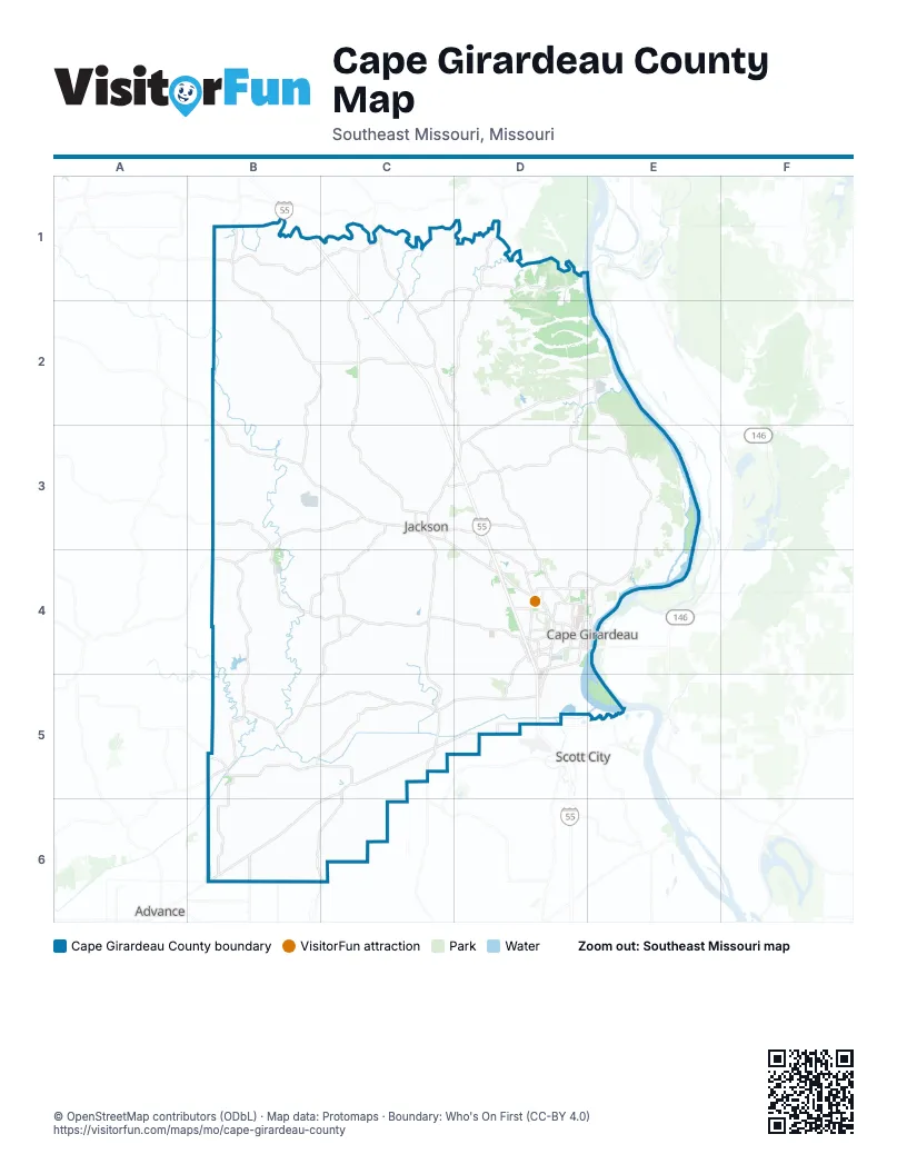
Maps inside Cape Girardeau County
2 maps inside, from the street map of Cape Girardeau County down.
Street index of Cape Girardeau County
Each street on the sheet and the grid squares it crosses.
- Shawnee ParkwayD4, E4
- North KingshighwayD4
- South KingshighwayD4, D5
- William StreetD4, E4
- East Jackson BoulevardC3, D3, D4
- West Jackson BoulevardC3
- North High StreetC3, D3
- South Hope StreetC3, C4
- North Hope StreetC3
- Bill Emerson Memorial BridgeE4
- East State StreetC5
- East Washington StreetC3
- West State StreetC5
- Big Bend RoadE3, E4
- North Mount Auburn RoadD4
- South Sprigg StreetD4, D5
- East Main StreetC3, D3, B5
- Lexington AvenueD4, E4
- La Salle AvenueD3
- Nash RoadD5
- North Sprigg StreetD4, E4
- Broadway StreetD4, E4, B5
- North Main StreetE4
- West Main StreetC3, B5
- North Liberty StreetC5
- Mason StreetD4, E4
- South Main StreetE4
- Chestnut StreetE4
- County Road 233C4, C5
- County Road 274B6, C6
- County Road 361B3, B4, C4
- County Road 241C5
- County Road 335C3, C4
- Independence StreetD4, E4
- Perryville RoadD4
- West Cape Rock DriveD4, E4
- Veterans Memorial DriveD3, D4
- South Silver Springs RoadD4, D5
- County Road 205D4, D5
- Hopper RoadD4
- Bloomfield RoadD4
- County Road 620D3, D4
- Main StreetC2, D2, B3, C4
- Bainbridge RoadC3, D3
- North Farmington RoadC3
- County Road 365B4, C4
- County Road 347B3, B6
- County Road 371B4, B6
- South West End BoulevardD4
- Northwest Westend BoulevardD4
- South Farmington RoadC3, C4
- Southern ExpresswayD4
- Kingsway DriveD4
- Bertling StreetD4, E4
- Siemers DriveD4
- County Road 273B6
- West Independence StreetC3
- Boutin DriveD4
- New Madrid StreetD4
- South Old Orchard RoadD3, D4
- North Spanish StreetE4
- County Road 238B5, C5
- East Rodney DriveD4
- South Fountain StreetD4, E4
- Cape la Croix RoadD4
- Caruthers AvenueD4
- North Cape Rock DriveD4
- Morgan Oak StreetD4, E4
- South Shawnee BoulevardC3
- Olive StreetC3, D4, E4
- Sheridan DriveD4
- County Road 643E4
- Carrie StreetB5
- Rampart StreetD4
- South Spanish StreetE4
- Old Rock RoadC5
- Kurre LaneD4
- County Road 306D3
- Harbor RoadE5
- Jackson StreetC2
- East Outer RoadD5
- County Road 525D1, D2, E2
- Levee RoadB5, C5
- County Road 253B5, B6
- County Road 532D2
- County Road 324C4
- County Road 411B1, B2, C2
- County Road 535D1, D2, E2
- County Road 472B2, C2
- Outer LaneC5, D5
- County Road 439C2, C3
- County Road 635E3, E4
- County Road 244C5
- County Road 651E3, E4
- County Road 621D3, D4
- County Road 436C2, C3
- County Road 318C4, D4
- County Road 379B4
- County Road 432C2, B6
- County Road 522C2, D2
- County Road 203C4, D4
- County Road 634D3, E3
- County Road 412B2, C2
- County Road 264B1, C6
- County Road 513C1, D1
- County Road 415B1, B2
- County Road 553D2
- County Road 435C3
- County Road 231C4, C5
- County Road 471B2
- Larch LaneC2, C3, D3
- County Road 349B3
- County Road 543D2, D3
- County Road 383B4, B5
- County Road 222C4
- County Road 351B3
- County Road 350B3
- County Road 607D2, D3
- County Road 506C1
- County Road 481B2, B3
- County Road 512C1
- County Road 638D3, E3
- County Road 422B2
- County Road 618D3
- County Road 442C3
- County Road 214C4, C5, D5
- County Road 316C4, D4
- County Road 343C3, C4
- County Road 261B5, B6
- County Road 227C4, C5
- County Road 427C2
- County Road 389B4, B5
- County Road 459C2, C3
- County Road 510C1, C2
- County Road 419B1, B2
- County Road 206D4
- County Road 408B1, C1, C2
- County Road 458B2, C2
- County Road 262B6
- County Road 255B5
- County Road 401B1
- County Road 380B4
- County Road 485B2, B3
- County Road 465C3
- County Road 413B1, B2
- County Road 354B3
- County Road 228B2, C4, C5
- Themis StreetD4, E4
- County Road 226B2, C4
- County Road 601D3
- County Road 375B4, C4
- Old Cape RoadC3, D3, D4
- County Road 616D3
- Moccasin Springs RoadE3
- Berberis LaneC2, C3
- County Road 208C4, D4
- County Road 265B6, C6
- County Road 425B2
- County Road 454B2, C2, B4
- County Road 327C4
- County Road 603D3
- Bella Vista DriveD2, D4
- County Road 271B6
- County Road 469B3, C3
- County Road 450C3
- County Road 407B1
- Greensferry RoadC3, D3
- County Road 645D3, D4
- County Road 468C3
- County Road 337C4
- County Road 524D1, D2
- Hill RoadE2, E3
- County Road 346B3, C3
- County Road 272B6
- County Road 405B1
- County Road 516C1, D1
- East Cape Rock DriveE4
- County Road 433C2
- County Road 404B1
- County Road 630E3
- County Road 236B5, C5
- County Road 341C3, C4
- County Road 268B6
- County Road 391B5
- Commerce RoadD5
- County Road 477B2
- County Road 254B5
- County Road 352B3
- County Road 218D5
- County Road 640E3, E4
- County Road 250C5
- County Road 520C2
- Ridge RoadC3, D3
- Catuse LaneE3
- Good Hope StreetD4, E4
- County Road 544D2
- County Road 420B1
- County Road 319D4
- County Road 330C3
- County Road 440C2
- Oak StreetB2, C3
- County Road 614D3
- County Road 514C1
- County Road 462B3, C3
- County Road 476B2
- County Road 209C4, D4, C5
- Limber Pine RoadB2
- Old Sprigg Street RoadD4
- County Road 521C1, C2
- County Road 549D2
- Orchid LaneC2
- County Road 369C4
- County Road 229C4, C5
- County Road 403B1
- County Road 501C1
- County Road 204C5, D5
- County Road 267B6
- County Road 387B5
- County Road 249C5, C6
- County Road 370B3, B4
- County Road 649E3
- County Road 325C4
- North Henderson AvenueD4
- County Road 453C2
- County Road 483B2
- County Road 606D3
- County Road 623E3
- County Road 329C4
- County Road 213D4, D5
- County Road 416B2, C2
- County Road 503C1
- County Road 444C3, B5
- Amber LaneB3
- Clark StreetC3, C4, D4
- County Road 266B6, C6
- County Road 613E3
- County Road 519C2
- County Road 363B3, B4
- Overlook RoadE2, E3
- County Road 504C1
- County Road 637E3
- Lee AvenueC3, C4
- Old Toll RoadC3
- County Road 625E3
- County Road 612E3
- Snapdragon LaneC1
- County Road 452B2, C2
- County Road 340C4
- County Road 515C1
- County Road 473B2
- Old Cape Road EastD4
- Greenbrier DriveD4
- Carolina PlaceC4
- County Road 475B2
- Begonia LaneD2
- Torre LaneB2
- North Hills DriveD3
- County Road 376B4, C4
- Hohokam LaneD3
- Old Hwy 61D5
- County Road 313D4
- County Road 394B5
- County Road 362B4
- South Pacific StreetD4
- South Ellis StreetD4
- Cypress DriveC2, D4
- South Benton StreetD4
- County Road 314D4
- County Road 360B3
- County Road 247C5
- County Road 381B4
- County Road 332C4
- County Road 508C1
- County Road 251B5, C5
- County Road 277B6, C6
- Dalhousie DriveD5
- County Spur 510C1
- Asarum LaneD2
- Clay LaneB4
- County Road 482B3
- County Road 366C4
- Mohave LaneE3
- County Road 546D2
- Grandview DriveC4, D4
- County Road 263C5
- Highland DriveC3, D4
- Old Route VE4
- Whitener StreetD4
- Kenneth DriveD4
- County Road 457C2
- Sherwood DriveD4
- College StreetD4
- County Road 377B5
- County Road 523D1
- Gordonville RoadD4
- Walden BoulevardD4
- County Road 605D2, D3
- Big Oak LaneB4
- Liberty School RoadC2
- Forsythia LaneC1
Things to do on the Cape Girardeau County map
Places on the map
- Allenville
- Apple Creek Conservation Area
- Apple Creek Shooting Range
- Arena Park
- Bella Vista Lake
- Bent Creek Golf Club
- Big Swamp
- Brookside Park
- Buzzi Unicern
- Cape Girardeau
- Cape Girardeau Country Club
- Cape Girardeau County Park North
- Cape Jaycee Municipal Golf Course
- Cape West
- Cape West Crossing
- Cape Woods Conservation Area
- Cedar Lake
- Dalhousie Golf Club
- Delta
- Doctors Park
- Dutchtown
- Gordonville
- Horseshoe Bend Slough
- Independence West Commons
- Indian Creek Wild Area
- Jackson
- Jackson City Park
- Kimbeland Country Club
- Lake Girardeau
- Marquette Island
- Neely's Landing Quarry
- Oak Ridge
- Old Appleton
- Peewah Trail - East Loop
- Peewah Trail - West Loop
- Riverfront Park
- Trail of Tears State Park
- Vancill Hollow Natural Area
- Whitewater
- Windy Bar Island Conservation Area
Next to Cape Girardeau County
- Advance
- Scott City
© OpenStreetMap contributors, Open Database License, openstreetmap.org/copyright · Map data: Protomaps · Boundary: Who's On First (CC-BY 4.0); Quattroshapes (CC BY 2.0)















