

Missouri map
Johnson County map
About 55,880 people live here (Census Bureau, 2024 estimate). The sheet's index lists 300 streets; North Main Street, South Main Street and Northwest 800th Road cross the most grid squares. Things to do inside the boundary: Warrensburg.
Open the map (PDF, US Letter)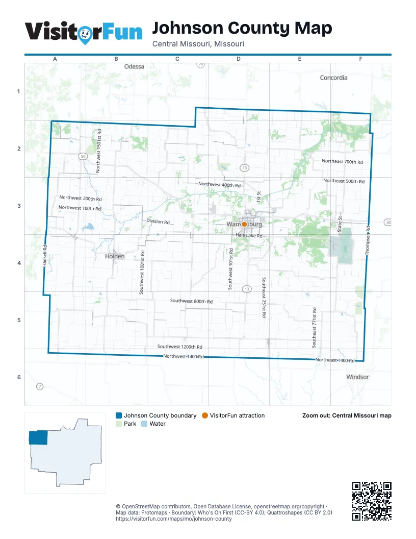
Maps inside Johnson County
1 map inside, from the street map of Johnson County down.
Street index of Johnson County
Each street on the sheet and the grid squares it crosses.
- North Maguire StreetD3
- South Maguire StreetD3, D4
- Northwest 800th RoadA2, B2, C2, D2
- Northwest 450 RoadB2, B3, C3, D3
- Northwest 450th RoadA2, B2, D3
- Northeast 75F3
- 1551st RoadB5
- East Hale Lake RoadD4
- Southwest 925th RoadB5, C5
- East Gay StreetD3
- East Young StreetD3
- South Ridgeview DriveD3, D4
- South State StreetF3, F4
- South Holden StreetD3, D4
- Northwest 21st RoadD1, D2, D3
- North Lexington StreetB4
- North Holden StreetD3
- South Olive StreetA4, B4
- North State StreetF3
- South Lexington StreetB4
- West McPherson StreetF3
- South Pine StreetB4
- North Ridgeview DriveD3
- North Lee StreetD5
- West Young StreetD3
- East 2nd StreetB4
- East 10th StreetB4
- West 2nd StreetB4
- PCA RoadD3
- West Pacific StreetA4
- Burkarth RoadD3
- East McPherson StreetF3
- South Lee StreetD5
- 201st RoadD2, D3
- Stahl DriveD3
- Southwest 200th RoadA4, B4, C4, D4
- Southwest 850th RoadA5, B5, C5, D5
- Northwest 400th RoadA3, B3, C3, D3
- West Division RoadA3, B3, C3
- Southwest 951st RoadC3, B4, C4
- Northwest 150th RoadB3
- Northwest Division RoadD3
- Northwest 1901 RoadA2
- Veterans RoadD3, E3
- North Main StreetC3, D3, B4, C4, C5, D5
- Hawthorne BoulevardD3
- Northwest 1021st RoadB3
- Broad StreetD3
- Spirit BoulevardE4, F4
- West Hale Lake RoadD4
- South Mitchell StreetD3, D4
- East Clark StreetD3
- East North StreetD3
- East Russell AvenueD3
- West Pine StreetD3
- Montserrat Park RoadD3
- West Gay StreetD3
- Northwest 1000 RoadA2, A5
- Patrick RoadD3, D4
- Southwest 250th RoadB4, D4
- Cooper BoulevardD3
- Southwest 101 RoadD4
- Grover StreetD3
- Pertle DriveD3, D4
- South Warren StreetD3
- North Warren StreetD3
- Southwest DriveD3
- MitchellF4
- Chestnut StreetD3, A4, B4
- North Olive StreetA4, B4
- West 9th StreetB4
- West Russell AvenueD3
- State Spur 58C4
- North Mitchell StreetD3
- Rainbow RoadA6
- East Cline RoadA2
- Southwest 1200th RoadB5, C5, D5
- Southwest 800th RoadA5, B5, C5, D5
- Southwest 600th RoadA4, B4, C4, D4
- Northwest 200th RoadA3, B3, C3, D3
- Southwest 601st RoadC3, C4, C5
- Southwest 500th RoadA4, B4, C4, D4
- Northeast 500th RoadD2, E3, F3
- Southwest 1101st RoadB3, B4, B5, B6
- Southwest 700th RoadA4, B4, C4, C5
- Southwest 1000th RoadA5, B5, C5, D5
- Southwest 400th RoadA4, B4, C4, D4
- Northwest 1400 RoadB6, C6, D6
- Northeast 700th RoadD2, E2, F2
- Northwest 100th RoadA3, B3, C3
- Southeast 251st RoadD4, D5
- Southwest 101st RoadD4, D5, D6
- Southwest 1501st RoadB3, B4, B5
- Southwest 300th RoadA4, B4, C4, D4
- Southwest 701st RoadC3, C4, C5
- Southeast 201st RoadD4, D5
- Southwest 301st RoadD3, D4, D5
- Northwest 701st RoadC2, C3
- Northwest 1251st RoadB2, B3
- Southwest 1001st RoadB4, B5
- Southeast 350th RoadD4, E4, F4
- Southeast 1000th RoadD5, E5, F5
- Northeast 1400 RoadD6, E6, F6
- Southeast 650th RoadD4, E4, E5, F5
- Northwest 1501st RoadB2, B3
- Southeast 900th RoadD5, E5, F5
- Southeast 771st RoadE4, E5, E6
- Northeast 1201st RoadF2, F3
- Northwest 700th RoadB2, C2
- Northeast 600th RoadD2, E2, F2
- Southeast 501st RoadE3, E4, E5, E6
- Northwest 500th RoadA2, B2, C2
- Northwest 600th RoadA2, B2, C2, D2
- Northwest 1150th RoadC1, D1
- Southwest 100th RoadA3, B3, C3, D3
- Northeast 851st RoadE1, E2, E3
- Northwest 1001st RoadB2, C2
- Northwest 250th RoadB3, C3
- Southeast 600th RoadD4, E4, F4
- Northwest 325th RoadA3, B3, C3
- Southwest 1871st RoadA4, A5
- Northeast 501st RoadE2, E3
- Northwest 50th RoadA3, B3, D3
- Southwest 401st RoadC3, C4, C5
- Northeast 175th RoadD3, E3, F3
- Northeast 251st RoadE2, D3, E3
- Northwest 1601st RoadB2, B3, A4
- Southwest 1250th RoadA6, B6, D6
- Southwest 1251st RoadB4, B5
- Southeast 301st RoadE4, D5, E5
- Southeast 401st RoadE4, E5
- Southwest 1301st RoadB5
- Southwest 801st RoadC4, C5
- Northeast 400th RoadE3, F3
- Southwest 1451st RoadB3, B4, B5
- Southeast 471st RoadE4, E5
- Southwest 151st RoadD5, D6
- Northeast 950th RoadD2, E2, F2
- Hadsell RoadA3, A4
- Southeast 1250th RoadD6, E6
- Northwest 301st RoadD2, D3
- Northeast 1100th RoadD1, E1, E2
- Southeast 1200 RoadD6, E6
- Northwest 621st RoadC2, C3
- Northwest 1771st RoadA2, A3
- Southwest 1821st RoadA3, A4, A5
- Southwest 1601st RoadA4, A5
- Northwest 575th RoadC2, D2
- Southwest 1201st RoadB3, B4
- Southeast 500th RoadD4, E4, F4
- Northwest 1201st RoadB2, B3
- Northwest 501st RoadC2, C3
- Northeast 121st RoadD1, D2
- Southwest 21st RoadD4, D5
- Southeast 601st RoadE5
- Northwest 1801 RoadA2
- Southeast 1100th RoadE5, F5
- Southwest 860th RoadB5, C5
- Northeast 201st RoadD1, D2, D3
- Southwest 1100th RoadA5, B5
- Southwest 950th RoadB5, C5, D5
- Southeast 1200th RoadF6
- Northwest 121st RoadD3
- Northwest 550th RoadA2, B2
- Northwest 850th RoadA2, B2, C2
- Northwest 901st RoadC2, C3
- Northwest 1401st RoadB2, B3
- 1st StreetD3, F4
- Southeast 725th RoadF5
- Southwest 1971st RoadA3, A5
- Northwest 871st RoadC2, C3
- Southeast 850th RoadE5, F5
- Southwest 750th RoadB5, C5, D5
- Bristle Ridge RoadE4
- Southwest 1801st RoadA5
- Thompson RoadF3, F4
- Southwest 75th RoadA3, B3
- Southeast 651st RoadE4, E5
- Northwest 700D2
- Northeast 900th RoadE2, F2
- Northwest 1050th RoadD1, D2
- Northeast 650 RoadD2, E2
- Northeast 550th RoadD2, E2
- Southwest 1150th RoadB5
- Northeast 625th RoadF2
- Southwest 1651st RoadA5
- Northwest 1821st RoadA2, A3
- South Main StreetD3, B4, C4, C5, D5
- Southeast 800th RoadE5
- Northwest 1101st RoadB2, B3
- Southwest 831st RoadC4, C5
- Southeast 300th RoadD4, E4
- Northeast 1025 RoadE2
- Southwest 1025st RoadC5, D5
- Northwest 1971st RoadA2, A3
- Northeast 521st RoadE1, E2, E3
- Southwest 1225th RoadA5, A6
- Southeast 951st RoadF4, F5, F6
- Northwest 1751st RoadA2
- Northeast 1000th RoadD2, E2, F2
- Northwest 521C2
- Southwest 25th RoadA3, B3
- Southwest 225th RoadB4
- Southwest 275th RoadA4
- Northwest 571st RoadC2
- Northwest 900th StreetC2, D2
- Northeast 221st RoadD2
- Northeast 1050th RoadD2, E2, F2
- Northwest 361st RoadC3, D3
- Northwest 1551st RoadB3
- Southeast 700th RoadD5, E5
- Northeast 1075th RoadF2
- Northeast 951st RoadF2, F3
- Northwest 350th RoadB3, C3
- Northeast 925th RoadF2
- Northwest 601st RoadC3
- Northwest 81D2
- Northeast 1125th RoadE1, F1
- Northwest 451C2
- Northwest 921st RoadC2, C3
- Southeast 341 RoadE3, E4
- Vandenberg AvenueF4
- Southwest 830th RoadA5, B5
- Southwest 50th RoadA3, B3, C3, D3
- Northeast 301st RoadE1, E2
- Southwest 1621st RoadA3, A5
- Southeast 601 RoadE4
- Northeast 451st RoadE1, E2
- Southeast 851st RoadE5
- Northwest 201D2
- Southeast 1101st RoadF5
- Northwest 375th RoadB2, B3, C3
- Northwest 105th RoadC3, D3
- Northeast 1200 RoadF1
- Northeast 801st RoadE2, E3
- Southwest 901st RoadC4, C5
- Southwest Division RoadC3, D3
- Northwest 950th RoadB2
- SW 100th RoadD3, D4
- Southwest 751st RoadC4, C5
- Northwest 650th RoadA2, B2, C2
- Southeast 1050th RoadF5
- Northwest 21D3
- Southwest 421st RoadE4, C5
- Southeast 1051st RoadF4, F5
- Northeast Division RoadD3, E3
- Northeast 875th RoadD2, E2
- Northwest 1051th RoadB3
- Southeast 275 RoadE4
- Northeast 701st RoadE1, E2
- Northwest 1371st RoadB2
- Southwest 371st RoadC4
- Southwest 771st RoadC5, C6
- Northwest 1571st RoadB2
- Southwest 325th RoadD4
- Southeast 321 RoadE4
- Southwest 180th RoadB4
- Northeast 300th RoadE3
- Northwest 625th RoadA2, B2, D2
- Northeast 200th RoadD3, E3
- Northwest 300th RoadA3, B3
- Northwest 201st RoadD1, D2, D3
- Southwest 71st RoadD5
- Northwest 430th RoadB2, B3
- Southwest 361st RoadC4, C5
- Northeast 1150th RoadD1
- Southwest 725th RoadC5
- Southwest 271st RoadD5
- Northeast 175F3
- Southeast 700 RoadE5
- Northwest 750th RoadC2, D2
- Northwest 1100th RoadC1, D1
- Southwest 375th RoadA4
- Northwest 271st RoadD1, D3
- Southeast 671 RoadE5
- East Market StreetD3
- Southeast 1201st RoadF4, F5
- Southeast 321st RoadE5
- Northwest 1621st RoadB2, A3
- Northwest 475th RoadB2, D3
- Southeast 371 RoadE5, E6
- Southwest 201st RoadD4, D5
- Southeast 171st RoadD4, D5
- East Division RoadE3, F3
- Northeast 825th RoadD2
- Southeast 475th RoadF4
- Northwest 821st RoadC3
- Southeast 100th RoadF4
- Southwest 675th RoadA4, D4
- Southwest 650th RoadA4, D4
- Southeast 860th RoadD5
- Northeast 641st RoadE3
- Northeast 421 RoadE2
- Northeast 250th RoadE3
- Southwest 51st RoadD4, D5
- Northeast 361st RoadE2
- Northwest 1025C2
- Arnold AvenueF4
- Southeast 525th RoadE4
- Southeast 1251st RoadF4
Things to do on the Johnson County map
Places on the map
- Camp Bobwhite Group Camp
- Carey Mims Lake
- Cave Hollow Park
- Centerview
- Chilhowee
- Clearfork Lake
- Crest Ridge R-VII Schools
- Gann Lake
- Hawthorne Park
- Hawthorne Shopping Centre
- Hazel Hill Conservation Area
- Hazel Hill Lake
- Hickory Hills Lake
- Holden
- Holden City Lake
- Holden R-III School District
- Ike Skelton Park
- Ike Skelton Park running path
- J. N. Turkey Kearn Memorial Wildlife Area
- Katy Trail State Park
- Keth Memorial Golf Course
- Kingsville
- Knob Noster
- Knob Noster State Park
- La Tour
- Lake Buteo
- Lake Pajastka
- Leeton
- North Loop Trail
- Pertle Springs
- Pool 1
- Pool 2
- Powell Gardens
- Ralph and Martha Perry Memorial Conservation Area
- Royal Oaks Golf Course
- Sandstone Country Club
- Warrensburg
- West Park
- Whiteman AFB
- Whiteman Air Force Base
Next to Johnson County
- Concordia
- Odessa
- Windsor
© OpenStreetMap contributors, Open Database License, openstreetmap.org/copyright · Map data: Protomaps · Boundary: Who's On First (CC-BY 4.0); Quattroshapes (CC BY 2.0)















