

Missouri map
Warrensburg map
About 19,998 people live here (Census Bureau, 2024 estimate). The sheet's index lists 300 streets; East Hale Lake Road, East Market Street and Grandview Drive cross the most grid squares. Also on it: Cave Hollow Park, Hawthorne Park and Hawthorne Shopping Centre.
Open the map (PDF, US Letter)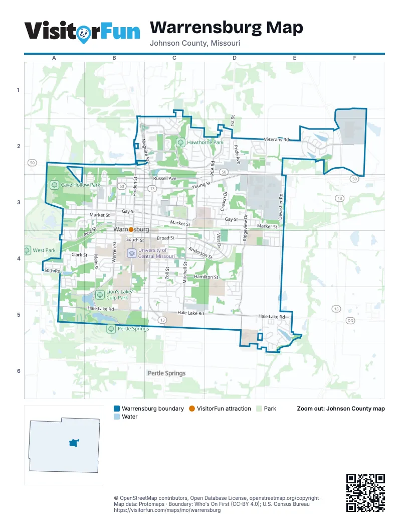
Street index of Warrensburg
Each street on the sheet and the grid squares it crosses.
- North Maguire StreetB2, C2, C3
- South Maguire StreetC3, C4, C5
- East Hale Lake RoadB5, C5, D5, E5
- East Gay StreetB3, C3, D3
- East Young StreetB3, C3, D3
- South Ridgeview DriveD3, D4, D5
- South Holden StreetB3, B4, B5
- North Holden StreetB2, B3
- North Ridgeview DriveD3
- West Young StreetA3, B3
- PCA RoadD2, D3
- Burkarth RoadC3
- Stahl DriveD2
- Northwest 21st RoadB2
- Veterans RoadD2, E2, F2
- Hawthorne BoulevardB2, C2, D2
- Broad StreetB4, C4, D4
- South Mitchell StreetC3, C4, C5
- East Clark StreetB4, C4
- East North StreetB3, C3
- East Russell AvenueB3, C3, D3
- West Pine StreetB3, A4, B4
- West Hale Lake RoadA5, B5
- Montserrat Park RoadD4, E4
- West Gay StreetA3, B3
- Cooper BoulevardB2, C2
- Grover StreetB4, C4
- Pertle DriveB5
- South Warren StreetB3, B4
- North Warren StreetB3
- Southwest DriveB4, A5, B5
- North Main StreetB3
- West Russell AvenueB3
- North Mitchell StreetC3
- Northwest Division RoadA4
- Patrick RoadA4
- East Market StreetB3, C3, D3, E3
- Hamilton StreetC4, D4
- Zoll StreetC4, C5
- Anderson StreetC4, D4
- West Market StreetA3, B3
- North College StreetB2, C2, B3
- South Washington StreetB3, B4, B5
- South Main StreetB4, B5
- Grandview DriveC2, D2, A4, A5
- Northeast 175th RoadB1, C1
- North Devasher RoadE3
- Christopher StreetC4, D4
- North Simpson DriveB1, B2, C2
- Vest DriveC4, D4
- Old State Highway HHE2, F2
- North Washington StreetB3
- West Culton StreetB3
- Cheatham CourtC2
- Laurel DriveB2, B3
- Creach DriveD3
- East Culton StreetB3, C3, C4
- North Water StreetB3
- Northeast 201st RoadE2
- Northfield Park BoulevardC2, D2
- West North StreetB3
- West South StreetB4
- East Young AveD3, E3
- Jefferson StreetC4
- McGoodwin StreetB4
- 1st StreetD2
- Ming StreetB4
- Corporate DriveD3, E3
- Pride AvenueD2
- West Clark StreetA4, B4
- Pembrooke DriveE5
- Southeast 201 RoadD5, D6
- Spring Ridge DriveA4, A5
- North Enterprise DriveD3, E3
- Stoneybrooke DriveD2, E2
- Foster LaneC3, D3
- Ridge DriveC4, D4
- Hillcrest DriveB4
- Chaucer LaneC3, D3
- Tyler AvenueC4, D4
- Deer RunC4, C5
- Hillman LaneE2
- Rich BoulevardE2
- Swallow StreetC4, C5
- Pebblecreek DriveD2
- South College StreetB3, B4
- Marshall StreetB3
- King StreetB4
- Nottingham DriveE5, E6
- Essex DriveE5
- Regent DriveD3
- Foxridge DriveD2
- Quail TrailC5
- Cypress CourtC2
- Franklin AvenueC4
- Poplar StreetC1, C2
- Blake Anthony DriveC5
- Jones AvenueB4
- Woodlawn DriveC2
- Fox Run DriveD2
- Park AvenueD2
- Cantebury DriveC3, D3
- 50th RoadA4
- South Mulberry StreetB3, B4
- Walnut LaneC2, D2
- Madison AvenueB3, B4
- East Cleveland StreetB2, C2, C3
- Fairway DriveA3, B3
- Meadow LaneB5, C5
- Oakmont DriveA4
- Greenwood CircleB4
- Jackson StreetC4
- West Oak StreetB3
- West Sparks StreetB3
- Polk StreetB3
- Cleburn StreetC4
- Iron Horse DriveA4
- Johnson AvenueB4
- East South StreetB4, C4
- Emerson StreetB3, C3
- Shotwell StreetB3
- East Sparks StreetB3, C3
- Railroad StreetB3, C3
- South Devasher RoadE3, E4
- Northwest 105th RoadB2
- Live Oak LaneA5
- Goodrich DriveB4
- Sunrise DriveE4
- High DriveA4, A5
- Purtle Springs RoadB5
- 8th StreetC4
- Sunset DriveE4
- Shamrock LaneD4, D5
- North Outer RoadD2, E2
- Streck DriveC3
- Wren WayC4
- CommanderC3
- North Charles StreetC3
- Cherry StreetC1, C2
- Kimberly DriveD5
- MeadowbrookC4, C5
- Fountain Hill RoadA4
- Timberline DriveA4
- Country Ridge DriveD5, E5
- Vivian DriveE2
- Roanoke DriveE5
- Care Center DriveD3
- Sandra DriveD2
- 9th StreetC4, D4
- Burlington RoadA4
- Deerfield DriveA3, A4
- Hidden Pines LaneA3, A4
- West Cleveland StreetB2
- Fairview AvenueB5
- Hollandale DriveE5, E6
- Missouri StreetB4
- Cedar DriveC5
- Holland SquareE2, F2
- Kimmy LaneD2
- Larkin StreetB5
- Wildflower RoadD2
- Sellman StreetD4
- South Marr DriveC5
- Bluebird BoulevardD4
- Darrow StreetA4
- 2nd StreetA3
- Larkin CourtC5
- Chapel RoadD3
- Wilkes DriveC3
- Acorn PlaceD3
- North Mulberry StreetB3
- Land StreetC3
- East Praire Hill DriveD3
- 10th StreetD4
- Coventry CourtD2
- Dawn DriveD3
- East Mill StreetC3
- Hazlewood DriveC4
- Walnut WayA4
- Dustins WayE5
- Hallbrooke DriveD4, D5
- West Mill StreetA3
- Fawn LaneE6
- Vamo RoadB3
- 3rd StreetA3
- Brookside DriveD4, D5
- East Hunt StreetB4
- Aspen WayC2
- Willow CourtC2
- Edgewood DriveA4, B4
- South Charles StreetC3, C4
- Patterson DriveB3
- Wildwood CourtA3, B3
- Estates DriveE2
- Charles StreetC3
- Basswood StreetC2
- Parkway DriveE4
- Summer PlaceE4
- Maple StreetB3
- Bedford DriveD2
- Houx StreetB4
- West King StreetB4
- Greenwood LaneB5
- Ray StreetB2
- West Hunt StreetB4
- Carpenter StreetB4, C4
- Drummond StreetB4, C4
- Commercial StreetB3
- East Pine StreetB3
- Courtland StreetB3, C3
- Murray Hill DriveB3
- East Oak StreetB3, C3
- Furmeson StreetB3, C3
- Hickory StreetB2, B3
- Dan StreetB4
- 10th TerraceD4
- Cloverleaf DriveD2
- Colbern StreetB3
- Larson AvenueF2
- South Maguire TerraceC5
- Lakeview StreetB3
- Hancock StreetC3
- Kismet DriveD2
- Knoll DriveD3
- 8th TerraceC4
- Charleston CourtD4
- Rockford DriveD5
- 9th TerraceD4
- Cloverleaf CourtD2
- North Marr DriveC5
- Post Oak CourtA3, A4
- Half Day DriveE5
- Terrace DriveC4
- Cedar CourtC2
- Northeast 955ScE3
- 7th TerraceC4
- Northwest 10th RoadA3
- Quincy DriveD2
- Manitou Way DriveD2
- Emerald WayD2
- Northeast Division RoadE4
- Maynard StreetB3
- Pacific StreetA4
- Randolph StreetC3
- Applewood RoadC2
- Locust LaneA4
- Hampton DriveD2
- Windy WayB4
- Hawthorne Hill DriveA4
- Lawson DriveD3
- Hetlage WayE2
- Park PlaceB4
- Parsons AvenueB2
- Maxwell AvenueD3
- Villa DriveD5, E5
- Coventry DriveD2
- Grant DriveB5, C5
- Sunflower StreetD4
- Longwood CourtD5
- Schroeder CourtE2
- Austin CourtE2
- Birch StreetD3
- Manor DriveD3
- Southwest 75th StreetA5
- Saxony DriveD2
- Terry Dale DriveD3
- Tracy LaneD3
- Redwood StreetE3
- Highland AvenueC4
- Redbud CourtC2
- Kensington CourtD5
- Cambridge DriveE5
- Park LaneC2, D2
- Sycamore CourtC2
- Bearcreek CircleE6
- 4th StreetA3
- Club House DriveA4
- Chestnut StreetB3
- Sunset RoadA3
- Aubrei WayE5
- Hurricane HillC4
- Lobbon StreetB3
- Olive CourtC2
- Juniper CourtC5
- Plaza PlaceD3
- Benjamin DriveB3
- Bowen StreetC4
- Riata RoadE3
- Sierra AvenueA4
- Council TrailA5
- Hout StreetB3
- Brittany DriveD3
- Chelsea CourtD2
- Talon CourtE3
- Mallory CourtC5
- Orient StreetA4
- Manitou CourtD2
- Alkire ParkwayC5
- Westgate DriveB3
- Casey CourtD2
Places on the map
- ALDI
- Alley Cats Entertainment
- AMC CLASSIC Warrensburg 10
- Audrey J. Walton Stadium
- Best Western Warrensburg Inn
- Bethlehem Lutheran Church
- Blind Boone Park
- Boss Body Fitness
- Cave Hollow Park
- Glasscock Plaza
- Grover Park
- Hawthorne Park
- Hawthorne Shopping Centre
- Lion's Lake/Culp Park
- Lions Lake
- Maple Grove Elementary School
- Marr Park
- Northpark Shopping Centre
- Pertle Springs Lake (resovoir)
- Ridge View Elementary School
- Santa Fe Shopping Centre
- Selmo Park
- Sunset Hill Cemetery
- Trails Regional Library
- United States Post Office
- University of Central Missouri
- Walmart Supercenter
- Warrensburg Area Career Centre
- Warrensburg High School
- Warrensburg Middle School
- Warrensburg Veterans Home
Next to Warrensburg
- Pertle Springs
© OpenStreetMap contributors, Open Database License, openstreetmap.org/copyright · Map data: Protomaps · Boundary: Who's On First (CC-BY 4.0); U.S. Census Bureau















