

Missouri map
Marshall map
About 13,791 people live here (Census Bureau, 2024 estimate). The sheet's index lists 234 streets; Santa Fe Trail, West Arrow Street and South Odell Avenue cross the most grid squares. Also on it: Indian Foothills Park, Marshall Memorial Municipal Airport and Amary Lake.
Open the map (PDF, US Letter)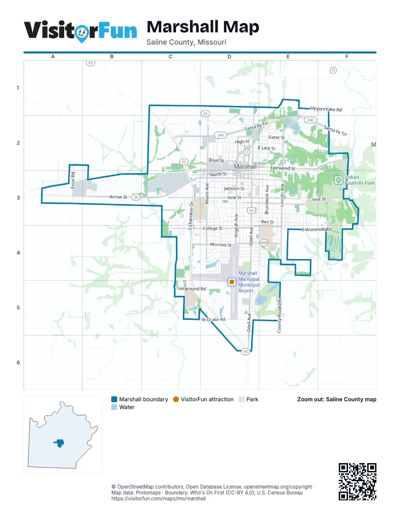
Street index of Marshall
Each street on the sheet and the grid squares it crosses.
- North Speyer LaneC1, C2
- Kenny DriveD1, D2
- North Odell AvenueD1, D2, D3
- North Ring Ridge DriveD1, D2
- Meyers Lake RoadE1, F1
- County Road 429A2
- Excel RoadA2, A3
- Santa Fe TrailC2, D2, E2, F2
- Anita DriveD2
- Bond AvenueD2
- Chestnut DriveD2
- East Boyd StreetD2
- East Eastwood StreetD2, E2, F2
- East Haynie StreetD2
- East High StreetD2, E2
- East Lacy StreetD2, E2
- East Marion StreetD2, D3
- East Ohio StreetD2, E2
- East Porter StreetD2, E2
- East Slater AvenueD2
- East Slater StreetD2, E2
- Franklin AvenueD2
- Grant AvenueD2, D3
- HorseshoeD2
- Lacy StreetD2
- North Allen AvenueD2, D3
- North Bell AvenueD2, D3
- North Benton AvenueD2, D3
- North Commercial DriveD2, E2
- North Ellsworth AvenueD2, D3
- North English AvenueD2, D3
- North Grant AvenueD2
- North Hamner AvenueD2
- North Jefferson AvenueD2, D3
- North Lafayette AvenueD2, D3
- North Lyon AvenueD2, D3
- North Mellisa AvenueD2
- North Miami AvenueD2, D3
- North Russell StreetD2
- North Salt Pond AvenueD2, D3
- Ohio StreetD2
- Porter StreetD2
- Ridge StreetD2
- Seargent AvenueD2
- SebreeD2
- Ted AvenueD2
- Voorhees AvenueD2
- Wall StreetD2
- West Boyd StreetD2
- West Darling StreetD2
- West Eastwood StreetD2
- West High CircleD2
- West High StreetD2
- West Marion StreetD2, D3
- West Ohio StreetD2
- West Porter StreetD2
- West Ridge StreetD2
- West Slater AvenueD2
- West Slater StreetD2
- Conway AvenueE2
- East Felix StreetE2
- East Shamrock DriveE2
- East State StreetE2
- Nicholas CircleE2
- North Bagby AvenueE2
- North Brunswick AvenueE2, E3
- North Conway AvenueE2
- North Cortney AvenueE2
- North Garfield AvenueE2
- North Lincoln AvenueE2, E3
- Park AvenueE2, E3
- State School Lake RoadE2, F2
- West Star StreetE2
- Indian Valley TrailF2
- Miller AvenueF2
- North Ridge TrailF2, F3
- Osage DriveF2, F3
- Seminole CourtF2
- County Road 331A3
- West Arrow StreetA3, B3, C3, D3
- Navajo DriveC3
- North Milkyway AvenueC3, D3
- Seminole DriveC3
- South Apache DriveC3, C4
- South Cherokee DriveC3, C4
- South Davis AvenueC3
- South Hawthorne AvenueC3, C4
- South Westport DriveC3, C4
- Stedem RoadC3
- Wal-Mart DriveC3
- West Jackson StreetC3, D3
- West Morgan StreetC3, D3
- West North StreetC3, D3
- West Sunset StreetC3
- West The Oaks StreetC3
- West Thomas StreetC3, D3
- West Vest StreetC3, D3
- East Arrow StreetD3, E3
- East Gordon StreetD3, E3
- East Mitchell StreetD3, E3
- East North StreetD3, E3
- East Rea StreetD3, E3
- East Summit StreetD3, E3
- East Vest StreetD3, E3, F3
- East Yerby StreetD3, E3
- Effie StreetD3
- Gordon StreetD3
- Lyon AvenueD3
- Mitchell StreetD3
- North Jefferson StreetD3
- North Lafayette StreetD3
- Page StreetD3
- Rea StreetD3
- Ridge Crest RoadD3
- SimmonsD3
- South Bell AvenueD3
- South Benton AvenueD3, D4
- South Carroll AvenueD3
- South Edsel AvenueD3
- South Ellsworth AvenueD3, D4
- South English AvenueD3, D4
- South Grant AvenueD3, D4
- South Highland CourtD3, D4
- South Jefferson AvenueD3
- South Lafayette AvenueD3, D4
- South Lyon AvenueD3
- South Mar DriveD3
- South Miami AvenueD3, D4
- South Odell AvenueD3, D4, D5, D6
- South Olson AvenueD3, D4
- South Placida AvenueD3
- South Ravenal AvenueD3, D4
- South Salt Pond AvenueD3, D4
- South Tucker AvenueD3
- Washington StreetD3, E3
- West Clay StreetD3
- West Court StreetD3
- West Englewood DriveD3
- West Gordon StreetD3
- West Hillside DriveD3
- West Leawood DriveD3
- West Mitchell StreetD3
- West Plaza DriveD3
- West Rea StreetD3
- West Summit StreetD3
- West Washington StreetD3
- West Yerby StreetD3
- East Jackson StreetE3
- East Keg StreetE3
- East Thomas StreetE3
- East Vest CircleE3
- East Washington StreetE3
- Elaine AvenueE3
- Hinton AvenueE3
- Jackson StreetE3
- North Redman AvenueE3
- Oak DriveE3
- South Ann DriveE3, E4
- South Brunswick AvenueE3, E4
- South Conway AvenueE3, E4
- South Fairlawn AvenueE3, E4
- South Lincoln AvenueE3, E4
- South Park AvenueE3
- South Redman AvenueE3, E4
- South Redwing DriveE3
- South Sandy LaneE3
- South Sharp AvenueE3, E4
- South Stonehaven AvenueE3
- South Sunrise DriveE3, E4
- South Whippoorwill DriveE3
- Susan AvenueE3
- Arrowhead DriveF3
- Tomahawk TrailF3
- Atchison AvenueC4, C5
- Reynolds RoadC4
- South Alameda LaneC4
- South Stering AvenueC4, C5
- West Broadmoor StreetC4
- West College StreetC4, D4
- West Kay StreetC4, D4
- West Morrow StreetC4, D4
- Briarwood DriveD4
- Broadmoor StreetD4
- Carriage CourtD4
- Charles StreetD4
- Clara StreetD4
- Colby AvenueD4
- Crestwood DriveD4
- Dexter AvenueD4
- East Black StreetD4, E4
- East College StreetD4, E4
- East Edna StreetD4, E4
- East Highlander StreetD4, E4
- East Label StreetD4, E4
- East Laura StreetD4, E4
- East Meadow LaneD4, E4
- East Mission StreetD4, E4
- East Morrow StreetD4, E4
- East Prairie LaneD4, E4
- East Rosehill StreetD4, E4
- Gaslight CourtD4
- Linn AvenueD4
- North DriveD4
- North Lake DriveD4
- Olson AvenueD4
- Salt Pond AvenueD4
- South DriveD4
- South Lake DriveD4
- Vers StreetD4
- Viking LaneD4
- West Black StreetD4
- West College CircleD4
- West Highlander StreetD4
- West Mission StreetD4
- West Rosehill StreetD4
- West Thornhill LaneD4
- County Road 205E4, E5
- East Morrow CircleE4
- East Watermill RoadE4, F4
- Sunrise CourtE4
- Fairground RoadC5, D5
- Linden Tree ParkwayC5
- South Cotton RoadC5
- South Liberty RoadC5
- West Drake RoadC5, D5
- East Country Club DriveD5
- East Cypress BoulevardD5
- East Harrison StreetD5
- East Meadow Crest CourtD5, E5
- Kaye Wright RoadD5
- South Cypress DriveD5, E5
- South Villa CourtD5
- East Cambridge StreetE5
- Mueller RoadD6
Places on the map
- ALDI
- Amary Lake
- Amary Lake Park
- AutoZone
- Benton Elementary School
- Break Time
- Bueker Middle School
- Burns Athletic Complex
- Campbell-Lewis Funeral Home
- Comfort Inn
- Community Bank
- Community Bank of Marshall
- Covenant Presbyterian Church
- Cumberland Presbyterian Church
- Dollar Tree
- Driving Range
- Eastwood Elementary School
- Eckilson-Mabee Theatre
- Fairview Cemetery
- First Assembly of God
- First Baptist Church
- First Christian Church
- First Presbyterian Church
- First State Community Bank
- Fitzgibbon Hospital
- Foothill Hike
- Gill Memorial Baptist Church
- Holiday Lanes
- Horseshoe Courts
- Indian Foothills Golf Course
- Indian Foothills Park
- Lake Minesa
- Marshall Aquatic Center
- Marshall High School
- Marshall Memorial Municipal Airport
- Marshall Public Library
- Rasse Lake
- Ridge Park Cemetery
- Stone Hedge Golf Club
- Sunset Hill Cemetery
© OpenStreetMap contributors, Open Database License, openstreetmap.org/copyright · Map data: Protomaps · Boundary: Who's On First (CC-BY 4.0); U.S. Census Bureau















