

Missouri map
Saline County map
About 23,325 people live here (Census Bureau, 2024 estimate). The sheet's index lists 300 streets; Main Street, County Road 323 and 4th Street cross the most grid squares. Things to do inside the boundary: Annie and Abel Van Meter State Park, Arrow Rock State Historic Site and Marshall.
Open the map (PDF, US Letter)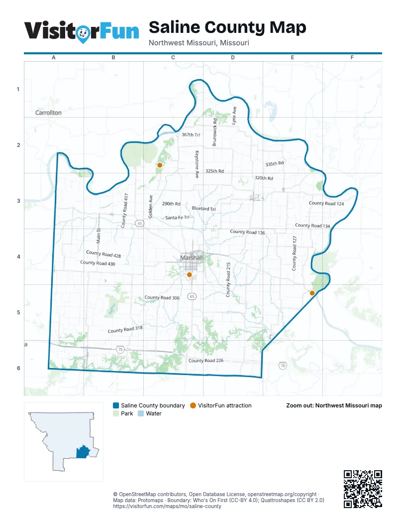
Maps inside Saline County
1 map inside, from the street map of Saline County down.
Street index of Saline County
Each street on the sheet and the grid squares it crosses.
- U.S. Submarine Veterans' Memorial HighwayB6, C6, D6
- Dwight D. Eisenhower HighwayA6, B6
- Santa Fe TrailC3, C4, D4
- South Odell AvenueC4
- East Eastwood StreetC4, D4
- North Odell AvenueC4
- Industrial BoulevardD3
- North Miami AvenueC4
- West Boyd StreetC4
- East State StreetB3, C4
- North Lafayette AvenueC4
- West State StreetB3
- County Road 328A6, B6, C6
- Main StreetB3, E3, A4, B4, E4, E5, A6, B6
- West Arrow StreetC4
- South Locust StreetB6
- East Vest StreetC4, D4
- South Miami AvenueC4
- West Vest StreetC4
- South Lincoln AvenueC4
- West College StreetC4
- North Lincoln AvenueC4
- East Yerby StreetC4
- North Broadway AvenueD3
- North Commercial DriveC4
- North Locust StreetB6
- East College StreetC4
- East Arrow StreetC4
- East Morrow StreetC4
- Garnett StreetE5
- North Jefferson StreetD3, C4
- East North StreetC4
- East 5th StreetE5
- South Broadway AvenueD3
- North Lafayette StreetC4
- County Road 326A6, B6, C6
- County Line RoadA4, A6
- North Elm StreetB3, A6, B6
- South English AvenueC4
- West North StreetC4
- West Morrow StreetC4
- South Elm StreetB3, A6, B6
- West Maple StreetD3
- North English AvenueC4
- North Jefferson AvenueC4
- North Euclid StreetD3
- Watts StreetD3
- East 1st StreetC2, E5, A6
- West Marion StreetC4
- North StreetE3
- North Bartlett StreetE3
- South Bartlett StreetE3
- North Salt Pond AvenueC4
- East Slater AvenueC4
- East Marion StreetC4
- West Court StreetC4
- West Slater AvenueC4
- North Outer RoadA6
- County Road 318A5, B5, C5, C6
- County Road 306A5, B5, C5
- County Road 215D4, D5, D6
- County Road 314A5, B5, C5
- County Road 127E2, E3, E4
- County Road 330A6, B6, C6
- County Road 126C3, D3, E3, F3
- County Road 134D3, E3, F3
- County Road 424A4, B4, C4
- County Road 129E3, E4
- County Road 428A4, B4, C4
- 320th RoadC3, D3, E3
- County Road 211D4, D5, D6
- County Road 430A4, B4, C4
- County Road 225D4, D5, D6
- County Road 304B4, C4, B5, C5
- County Road 415B3, B4
- County Road 317B4, B5, B6
- County Road 313B4, B5, B6
- County Road 130D3, E3, F3
- County Road 401A3, A4
- County Road 320A5, B5, B6, C6
- Private RoadC2, A3, B3, C3
- County Road 305A4, A5, A6
- County Road 422A3, B3, B4, C4
- County Road 323B4, C4, B5, C5, B6
- County Road 136D4, E4
- County Road 111D3, D4
- County Road 119E3, E4
- 335th RoadC2, D2, E2
- County Road 212D5, E5
- Golden AveC3, C4
- County Road 310B5, C5
- County Road 205C4, C5, C6
- Keystone AvenueC2, C3
- County Road 208C5, D5, E5
- County Road 220C5, D5, E5, D6
- County Road 332A6, B6, C6
- County Road 417B3, B4
- County Road 202D4, E4
- County Road 226C6, D6
- County Road 316B5, C5
- County Road 214C5, D5
- County Road 124E3, F3
- Brunswick RoadD1, D2
- County Road 309A4, A5
- County Road 139F3, E4, F4
- County Road 331C4, C5
- County Road 324A6, B6, C6
- 290th RoadB3, C3
- County Road 218C5, D5
- County Road 307A4, A5, A6
- County Road 301A4, A5
- County Road 224C6, D6
- County Road 117D3, D4
- County Road 216D5, E5
- 367th TrailC2, D2
- County Road 140C4, D4, E4
- County Road 333C5
- Bluebird TrailC3, D3
- Wildcat RoadC3, C4
- County Road 327C4, C5, C6
- Kite AveC3, D3, C4
- County Road 312A5, B5, C5
- County Road 228C6, D6
- County Road 146D4, E4
- 330th RoadB2, C2, D2
- County Road 407A3, A4
- County Road 403A3
- County Road 109D3, D4
- County Road 302A4, C4
- County Road 311A4, A5, A6
- Ivory TrailC1, C2
- County Road 416A3, B3, C3
- Harvest AvenueC3
- County Road 123E4
- County Road 420B3, C3
- County Road 335C5, C6
- 325th RoadC2, D2
- Coon Hollow RoadC2
- County Road 206D4
- County Road 203C6
- County Road 115D4
- Lindwood AvenueD2
- County Road 421B3, B4
- County Road 122C3, D3
- County Road 427C3, C4
- County Road 411B3, A4, B4
- County Road 315B5, B6
- County Road 135E2, E3
- County Road 334C6
- County Road 412B3
- County Road 223D5, D6
- County Road 410A3, B3
- County Road 128D3, E3, F3
- County Road 319B4, B5
- County Road 148E4
- Gazebo AvenueB2, C2
- County Road 113D3
- County Road 132E3, F3
- County Road 213D4
- County Road 107D3, D4
- County Road 233E4, E5
- Lynx AvenueD1, D2
- 403rd TrailC1, D1
- County Road 142D4
- Lotus AvenueD2
- County Road 339C5, C6
- County Road 429C4
- 305th RoadB3, C3, D3
- County Road 329C6
- County Road 432A4
- 385th LaneC1, D1
- County Road 210E5
- Guide AvenueC2, C3
- Montana AvenueD2, D3
- Klondike AvenueD2, D3
- County Road 219D4, D5
- County Road 405A3, A4
- Iron TrailC2
- 357th RoadD2
- County Road 150D4, E4
- 355th RoadE2
- County Road 231E5, E6
- Oasis TrailE2, E3
- 347th TrailD2
- County Road 406A3
- Huron TrailC2
- County Road 121E3
- 347th RoadC2
- County Road 322A5
- Mueller RoadC4, D4, C5, D5
- County Road 110E2
- 397th TrailD1
- County Road 337C5, C6
- McAllister RoadB6
- McKel AvenueD3
- County Road 325C5
- County Road 413B3
- County Road 217D5, D6
- Forest AvenueB2
- County Road 423C3, B4
- 300th RoadB3, C3
- 310th RoadD3, E3
- Nova AvenueE2, E3
- County Road 321B6
- West Drake RoadC4
- Park RoadB2, C2, B6
- Holly AveC3
- 337th RoadD2, E2
- Ladder AvenueD4
- Gusty LaneC2
- Mutmeg AvenueE2
- County Road 114E2, E3
- Levee top service roadA2, A3, B3
- County Road 409A3
- County Road 419B4
- County Road 303A6
- Otter TrailE2
- Country Club RoadD3, E3
- County Road 201C6
- South Redman AvenueC4
- Peach AvenueE2
- Van Meter Pinnacle DriveC2
- East Watermill RoadC4, D4
- County Road 408A3
- South Grant AvenueC4
- 327th RoadD2
- South Benton AvenueC4
- North Speyer LaneC4
- Novel AvenueE2
- Nettle AvenueD2
- County Road 207D6
- County Road 237E4, E5
- County Road 118E3
- County Road 222D6
- East Rea StreetC4
- County Road 308B5
- County Road 414A3, C3
- South Salt Pond AvenueC4
- South Lafayette AvenueC4
- County Road 125E4
- West Morgan StreetC4
- London AvenueD2
- Meyers Lake RoadC4, D4
- Gopher TrailC3
- Dragonfly DriveB3
- East Mitchell StreetC4
- County Road 144E4
- South Ellsworth AvenueC4
- 250th RoadC4
- 245th RoadC4
- 3rd StreetA3, A4, B4, E5
- North Main StreetC2, D3, A4
- Osprey AvenueE2
- West Jackson StreetC4
- Lookout LaneD2
- Fairground RoadC4
- County Road 131E3
- North Brunswick AvenueC4
- Newport LaneD2
- Osage DriveD4
- South Conway AvenueC4
- County Road 221D5
- South Linn StreetB3
- County Road 426A4
- Elm StreetD3
- Morgan StreetD3, E5
- County Road 204D4
- 4th StreetA3, A4, B4, E4, E5
- East Slater StreetC4
- Saline County Line RoadD6
- South Brunswick AvenueC4
- State School Lake RoadC4, D4
- Walnut StreetD3, A4, B6
- County Road 103C3, C4
- South Cypress DriveC4
- North Miller StreetB6
- 268th RoadD3
- County Road 404B3
- East High StreetA4, C4
- Porter StreetD3, E3, C4
- South Cherokee DriveC4
- West High StreetC4
- East Gordon StreetC4
- High StreetA4, E5
- County Road 235E4
- Leroy StreetD3
- South Jefferson AvenueC4
- Jenkins StreetD3
- West Thomas StreetC4
- 2nd StreetA3, A4, B4, E5
- County Line Road 432A4
- South Sharp AvenueC4
- 225th RoadD4
- County Road 105D3, C4
- County Road 418B3
- South Olson AvenueC4
- East Lacy StreetC4
- North Central AvenueD3
- West Yerby StreetC4
- Clyde StreetD3
Things to do on the Saline County map
Places on the map
- Amary Lake
- Amary Lake Park
- Annie and Abel Van Meter State Park
- Arrow Rock
- Arrow Rock State Historic Site
- Arrow Rock State Historic Site Campground
- Betty's Truck Stop
- Big Muddy National Fish and Wildlife Refuge Cambridge Bend Unit
- Big Muddy National Fish and Wildlife Refuge Cranberry Bend Unit
- Big Muddy National Fish and Wildlife Refuge Jameson Island Unit
- Big Soldier Lake
- Blackburn
- Blind Pony Lake
- Blind Pony Lake Conservation Area
- Blue Lick Conservation Area
- East Slough
- Fitzgibbon Hospital
- Gilliam
- Grand Pass
- Grand Pass Conservation Area
- Indian Foothills Golf Course
- Indian Foothills Park
- Lake Wooldridge
- Loess Hills Trail
- Malta Bend
- Malta Bend Community Lake
- Marshall
- Marshall Junction Conservation Area
- Marshall Memorial Municipal Airport
- Marshall Quarry
- Miami
- Mount Leonard
- Nelson
- Ridge Park Cemetery
- Slater
- Slater Lake
- Stone Hedge Golf Club
- Summers Lake
- Sweet Springs
- Utz Site
Next to Saline County
- Carrollton
© OpenStreetMap contributors, Open Database License, openstreetmap.org/copyright · Map data: Protomaps · Boundary: Who's On First (CC-BY 4.0); Quattroshapes (CC BY 2.0)















