

Missouri map
Ozark map
About 23,248 people live here (Census Bureau, 2024 estimate). The sheet's index lists 300 streets; American Legion Memorial Highway, North 21st Street and North 25th Street cross the most grid squares. Also on it: Airport Business Center, Finley Park and Finley River Park.
Open the map (PDF, US Letter)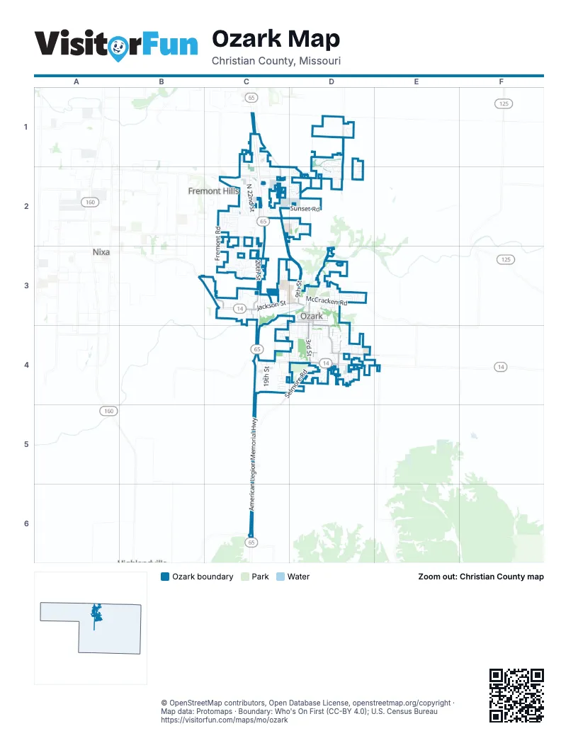
Street index of Ozark
Each street on the sheet and the grid squares it crosses.
- American Legion Memorial HighwayC1, C2, C3, C4, C5, C6
- Schoolcraft FreewayC1
- Jackson StreetC3, D3
- South 3rd StreetD3, D4
- North 3rd StreetD2, D3
- East South StreetD4
- West South StreetC4, D4
- West Jackson RoadC3
- North 20th StreetC2, C3
- Fremont RoadC2, C3
- South 14th AvenueD4
- North 9th StreetD2, D3
- Longview RoadC2
- Selmore RoadD4
- South 11th AvenueD4
- East Hartley StreetD4
- East McCracken RoadD3
- East Hartley RoadD4
- West Oak StreetC3, D3
- South 17th StreetC4
- Farmer Branch RoadC1, C2
- South 10th AvenueD4
- East Walnut StreetD3
- East Robertson StreetD3, D4
- North Pheasant RoadD2
- West Walnut StreetD3
- South 2nd AvenueD3, D4
- Old US Highway 65C2
- North 22nd StreetC2, C3
- North 21st StreetC1, C2, C3
- North 25th StreetC1, C2, C3
- West Richwood RoadC3
- South 9th StreetD3, D4
- North 19th StreetC1, C2, C3
- Southernview RoadD1
- West Garton RoadC2
- East Melton RoadD1
- South 19th StreetC4
- West Daniels LaneC4, D4
- South 5th AvenueD3, D4
- North 10th StreetD2, D3
- West Jay StreetC4, D4
- West Warren AvenueC4, D4
- North 12th StreetC2, D2, C3
- North 17th StreetC1, C2, C3
- North 24th StreetC2, C3
- North 12th AvenueD2, D3
- East JacksonD3
- South 6th AvenueD3, D4
- South 15th StreetC4
- North Riverside RoadD3
- South 3rd AvenueD3, D4
- South 12th AvenueD4
- South 11th StreetD3, D4
- West Hall StreetC3, D3
- Waterford BoulevardD1, D2
- North 10th AvenueD2, D3
- East Highview StreetD3
- East Lark StreetD4
- Venice AvenueC2
- North 7th AvenueD3
- East Samuel J StreetD4
- East County Line RoadD1
- North 30th StreetC2, C3
- North Town Center DriveC2
- West Farmer StreetC3, D3
- North 31st StreetC2, C3
- East Warren AvenueD4
- South 18th AvenueD4
- North 13th StreetC2, C3
- South 7th AvenueD3, D4
- North 4th AvenueD3
- East Georgia StreetD4
- West Sunset RoadC2, D2
- North Biagio StreetC2, C3
- North 14th StreetC3
- North 6th AvenueD2, D3
- South 1st StreetD3, D4
- West Turnberry BoulevardC2, D2
- 13th AvenueD1, D2
- Riverbluff DriveD2
- East Bingham StreetD3
- North 23rd StreetC2, C3
- Wisteria LaneD1
- East Melanie LaneD4
- West Waverly StreetC4, D4
- West Lifecare CircleC2
- West ColtonC3
- North 28th StreetC2, C3
- East Sycamore StreetD4
- West Bingham StreetC3
- North Marlin DriveC2
- McGuffey StreetC2, D2
- West Trevor TrailC3
- West Snider StreetC4, D4
- Florence AvenueC2
- East Bain StreetD4
- South 20th StreetC4
- South 6th StreetD3, D4
- 10th AvenueD1, D2, D4
- North 4th StreetD3
- West McGuffey StreetC2
- Riverside RoadD3
- North 14th AvenueD3
- School StreetC2, D2
- East Diane StreetD3
- West Deerbrooke TrailC1
- West Wren StreetD4
- Rome AvenueC2
- South 16th AvenueD4
- West Kirkwood StreetC4, D4
- Blue Stem RoadD1, D2
- East Elm StreetD3
- South 7th StreetD3, D4
- Cobblefield WayC2, D2
- Boat StreetC2
- East Oak StreetD3
- West Rainey StreetC4, D4
- West Parkview AvenueC3
- Lakeland DriveC3
- Siena AvenueC2
- South 17th AvenueD4
- West Church StreetD3
- Athens StreetC2
- West Webb RoadC2
- South 21st AvenueD4
- Chesapeak DriveD1
- North 29th StreetC2
- West Pebblebrooke DriveC4, D4
- East Wren StreetD4
- East Greenbridge RoadD3
- South 9th AvenueD3, D4
- South 13th StreetC4, D4
- Eagle Rock DriveD1
- North 18th StreetC3
- Countryside CourtC2
- North 11th StreetD2
- Walk on DriveC1
- South Solaira StreetD4
- South 4th StreetD3, D4
- South 5th StreetD3, D4
- South Thomas DriveD4
- West McCracken RoadD3
- West Elm StreetC3, D3
- South 14th StreetC4
- South 15th AvenueD4
- West Cover DriveC2
- North Skyview LaneC3
- West Diane StreetC3
- Elk Valley RoadD4
- West Jovie StreetC4
- East Parkview AvenueD3
- North 9th AvenueD2, D3
- North 8th AvenueD3
- North Jamestown StreetC3
- South 13th AvenueD4
- North 26th StreetC3
- North Government Plaza CircleC3
- West Hilltop RoadC1
- East Country Crest RoadD3
- West Grapevine DriveC1
- Madrid AvenueC2
- East Stone Ridge DriveD3
- East ChurchD3
- South 4th AvenueD3, D4
- West James River RoadC2
- West Skyline AvenueC2
- West Spring DriveC2
- East BarnesD3
- West Millpond DriveC3
- North 19th AvenueD3
- Becky LaneD4
- South Farm Road 195D1
- Lloyd StreetD2
- West RobertsonD4
- North 2nd AvenueD3
- South 20th AvenueD4
- South Brooke AvenueC4
- East Shoreline DriveD1, D2
- West Dawn StreetC3
- Ivy Creek DriveD2
- West Eunice StreetC4, D4
- West Brick StreetC3, D3
- Air Park RoadC2
- Amy LaneD4
- North 8th StreetD2, D3
- West Evangel StreetC3
- North 15th AvenueD3
- Lily DriveD1, D2
- Ina's TrailD4
- South Treetop CourtC4
- Shelton DriveD2
- East Maricopa AvenueD4
- West Liberty AvenueC2, D2
- Hampton DriveD1
- East ParkviewD3
- North 18th AvenueD3
- North Thistle DriveC2
- North 15th StreetC2
- 12th AvenueD2
- North Hawkins RoadD3
- East Fieldstone DriveD3
- South 16th StreetC4
- East Hayloft DriveD3
- East Sunset RoadD2
- Pebblebrooke DriveC4
- North 16th StreetC2, C3
- Bull Run RoadD4
- Fenwicke DriveD2
- Monte Carlo StreetC2
- West Yellow CircleD2
- North 21st AvenueD3
- Pintail DriveD1, D2
- 20th AvenueD1, D4
- East Current DriveD2
- East Windmill DriveD4
- Tuscany CircleC2
- West Heritage DriveC3
- North Farmington DriveD3
- North Patriot DriveD3
- East Silo Ridge DriveD3
- Palma CourtC2
- North 20th AvenueD3
- South 8th StreetD3, D4
- West Fisherman DriveC2
- April DriveD4
- West Black StreetD2
- Airpark RoadC2
- East Bayshore DriveD2
- East Sandpiper DriveD1, D2
- West Fishhook AvenueC2
- West Pigeon StreetC2
- 19th AvenueD1
- East Costa Mesa CourtD4
- East Osprey DriveC2
- North 2nd StreetD3
- West Miramar RoadC2
- Marler LaneC4
- East Cobblestone DriveD2
- Melton RoadD1
- MakenzieC3
- Southfork DriveD4
- North 23rd AvenueD3
- East Watermill CircleD4
- LloydC2
- RidgecrestD4
- Brinnsfield DriveD2
- Wakefield DriveD2
- West Landsdowne DriveD2
- Mesa DriveD2
- West ParkviewC3
- Bryant StreetD3
- North Cabinet DriveC1
- South 8th AvenueD3, D4
- KendallC3
- West Heights LaneC3
- East Robin StreetD4
- North 11th AvenueD3
- Ridgecrest AvenueC4
- SummerhillD4
- North Missouri DriveC3
- North 6th StreetD2, D3
- Vintage DriveD1, D2
- 11th AvenueD1, D2
- Buckhord RoadD4
- Lantana DriveD2
- East Farmer StreetD3
- South Nitro DriveC4
- 6th AvenueD1
- 29th StreetC2, C3
- Greenwhich DriveD2
- West SaratogaC2
- West Mason PlaceC3
- Candace StreetD4
- Valley Ridge RoadC4
- West MerlinC2, D2
- East Dawn StreetD3
- East Jay StreetD4
- West Ragweed CourtC4
- West Thorngate DriveC2, D2
- DennyD4
- Brookshire StreetD2
- West Windsor StreetD4
- Seacrest DriveD2
- South 12th StreetD4
- East Rainey StreetD4
- North Wagtail StreetC2
- North 5th StreetD3
- Skyline AvenueD2
- East DanielsD4
- West JonquilC3
- West Marler LaneC4
- 17th StreetC3
- East Hawkins CourtD3
- East Spring DriveD2
- North Williamsburg LaneC3
- East Swan StreetD4
- East Overland DriveD4
- West CalhounC2
- East Hall StreetD3
Places on the map
- Airport Business Center
- American Inn Ozark
- Americas Best Value Inn Ozark Springfield
- AutoZone
- B & B Ozark-Nixa 12
- Billy Gail's
- Braum's
- Casey's General Store
- Chapman Cemetery
- Christian County Commercial Park
- Christian County Discount Freight and Grocery
- Christian County Justice Center
- Christian County Library
- Commerce East
- CoxHealth Urgent Care Ozark
- Deerbrook Commercial
- Dollar General
- Finley Park
- Finley River Park
- Freemont Hills Towne Center
- Goodwill
- Great Southern Bank
- Guaranty Bank
- Hopedale Heights
- James River Church
- Lake Hills Church
- Lambert's Cafe
- Lamberts RV Park
- Lowe's
- Maverik
- McDonald's
- Neal and Betty Grubaugh Park
- Ozark Business Center
- Ozark East Elementary School
- Ozark High School
- Ozark Junior High
- Ozark Mountain Sports Complex
- Town and Country Village
- Twin Acres Commercial
- United States Post Office
Next to Ozark
- Fremont Hills
- Nixa map
© OpenStreetMap contributors, Open Database License, openstreetmap.org/copyright · Map data: Protomaps · Boundary: Who's On First (CC-BY 4.0); U.S. Census Bureau















