

Missouri map
Republic map
About 21,392 people live here (Census Bureau, 2024 estimate). The sheet's index lists 300 streets; James River Freeway, East Elm Street and East Hines Street cross the most grid squares. Also on it: Island Green Golf Club, Amazon STL3 and Miller Park Walking Path.
Open the map (PDF, US Letter)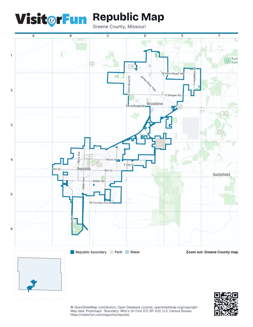
Street index of Republic
Each street on the sheet and the grid squares it crosses.
- James River FreewayD1, D2, E2
- West Republic RoadD3
- East Elm StreetB4, C4, D4
- West Elm StreetB4
- North Main AvenueB4
- South Main AvenueB4, B5
- West Farm Road 182D4
- South Farm Road 81B4
- East Sawyer RoadD2, E2
- East Hines StreetB4, C4, D4
- East Miller RoadB5, C5
- West County Line RoadB5, C5
- West Farm Road 178B4, D4
- South Haseltine RoadE1, E2
- North Oakwood AvenueC4
- North West AvenueB4
- South Illinois AvenueB5
- South Lynn AvenueC4, C5
- South Kansas AvenueB4, B5
- North Hampton AvenueB4, C4
- South Bailey StreetD4
- South Farm Road 89C5
- West Hines StreetB4
- South West AvenueB4, B5
- Williamsburg WalkC5
- East Bristol StreetD3
- West Miller RoadB5
- West Farm Road 140D1
- West Oneal RoadB5
- West Farm Road 186B5
- County Road 101D3
- South Farm Road 97D1, D2, D4
- South Farm Road 107E2, E3
- West Farm Road 148C1, D2, E2
- Beal RoadB5, B6
- East Rosewood StreetC4
- East Lee StreetC4, D4
- West Farm Road 144D1
- East Logan StreetC4, D4
- Grace StreetB5, C5
- East Hamilton StreetC4
- Farm Road 160D2
- RepMo DriveD3, D4, E4
- West Farm Road 170D3
- West Farm Road 174C4, D4
- North College AvenueB4
- East Harrison StreetB4, C4
- East Kentwood StreetC4, D4
- North Stone Falls RoadD3
- McLane Truck EntranceD2
- North Walnut AvenueB4
- South Farm Road 101D3
- West Carnahan StreetD1, D2
- South Farm Road 103D2, D3
- East Primrose LaneB4, C4
- West Farm Road 150E2
- North Cox AvenueC4
- East Hadley StreetB5, C5
- West Broad StreetB4
- North Pinewood AvenueC4
- North Boston LaneC4
- South Hampton AvenueB4, B5, C5
- East Ritter StreetB5, C5
- South Antietam RoadC5
- South Maple AvenueB4, B5
- East Leadership DriveD3, E3
- North Kyle AvenueC4
- South Basswood AvenueC4, C5
- West Farm Road 164D3, E3
- North Lynn AvenueC4
- East Grace StreetC5
- Park LaneC4, C5
- South Cumberland AvenueC5
- East Hardy StreetB5, C5
- East Halsey StreetB5, C5
- East Mill StreetB4, C4
- North Matteson AvenueC4
- Lombardy DriveB5, C5
- Park DriveB4, C4
- North Cottonwood AvenueC4
- North Pine AvenueB4
- South Cottonwood AvenueC4, C5
- South Concordia AvenueB4, B5
- West Hickory LaneC5
- East Moonlight StreetC4, D4
- South Sherman StreetD2
- East Charles StreetC5
- West Ruben LaneE2
- West Grant StreetB4
- South Forest LaneB4
- East Wilson StreetB4, C4
- South Allen DriveC4, C5
- West Grand Street RoadD1
- South Eagan StreetB4
- East New Madrid StreetC5
- Civic BoulevardB5
- Fountain AvenueC5
- Charles StreetC5
- South Shuyler LaneC5
- West Olive StreetB4
- South Appomattox AvenueC5
- West Farm Road 160D2
- East Jewell StreetB5, C5
- East Timber Oak StreetC4
- West Anderson StreetB4
- North Wynwood AvenueC4
- Magnolia AvenueC4, C5
- Jester AvenueD4
- Frisco BoulevardB5
- McLane Ozark Teammates/VisitorsD2
- South Calabria AvenueB5
- North Alexander AvenueC4
- West Logan StreetB4
- Brooks AlleyB4, C4
- North Allen AvenueC4
- South Buxton LaneB4
- North Fairwood DriveC4
- South Lipscomb DriveB5
- Keystone DriveD4
- Choctaw RoadB5
- North Blake AvenueC4
- West Mill StreetB4
- East Valley Trail DriveC5
- Jackson StreetB4
- South Walnut AvenueB4
- East Wood StreetC5
- South Teakwood AvenueC4, C5
- West Wilson StreetB4
- North George AvenueC4
- East Kimberly StreetB5, C5
- Colorado AvenueB5
- East Colonial StreetD4
- East Macon StreetC5
- South Ashton AvenueB5
- Sequoia StreetB5, C5
- Whitethorn DriveB5, C5
- South Gettysburg LoopC5
- Davis Bridge RoadC5
- North Lindsey AvenueC4
- South Atlantic StreetD2
- North Oak Court PlaceC4
- West Melody LaneB5
- Conroy AvenueC5
- South Ventura AvenueB4, B5
- South Cully AvenueC4, C5
- East Brooks StreetB4
- East Anderson StreetB4
- North Sandstone AvenueB4
- South Natchez AvenueC5
- West Summit StreetB4
- West Wade StreetB4
- Marshall StreetD4
- Texas AvenueD4
- East Cowling StreetB3, C3
- West Stanton DriveB4, B5
- South Venice AvenueB5
- North Basswood AvenueC4
- West Washington AvenueD2
- North Republic Commons DriveC4
- North Jasmine DriveC4
- South Rome AvenueB5
- West Kings StreetD1
- East Old Stone AvenueD3
- Navajo StreetB5
- North Douglas DriveD4
- West Charles StreetB5
- North Century PlaceD4
- Shirley AvenueB5
- Natchez RoadC5
- North Teakwood AvenueC4
- East Berry StreetB4
- Kristopher AvenueB5
- Lexington AvenueD4
- East Summit StreetC4
- Glenwood AvenueD4
- Ritter StreetC5
- South Franklin AvenueD4
- North Butternut AvenueB4
- South Sarah AvenueB4, B5
- South Dale AvenueC4
- South Dennis AvenueC4
- South Drenda AvenueC4
- South Kyle AvenueC4
- Westwood AvenueC4
- Northwood AvenueC4
- South Debbie AvenueC4
- West Jewell StreetB5
- East Foxborough DriveC4
- East Jared StreetC5
- South Fountain AvenueC4, C5
- East Haley StreetC4
- White Rock AvenueD4
- North Austin LaneC4
- South Cedarwood AvenueC4, C5
- South Dogwood AvenueC4
- White Oak AvenueC4
- South Redbud AvenueC4
- South Westfield AvenueC4
- North Cherrywood AvenueC4
- East Charlton StreetC5
- South Conroy AvenueC4, C5
- South Peach Tree LaneC4
- East Rachel DriveC5
- South Pinewood AvenueC4
- East Heritage StreetD3, D4
- South Farm Road 85C4
- West Christine LaneB5
- Chandler AvenueD4
- Lake DriveC3, D3, C4
- East Sandlewood StreetC4
- Delaware AvenueD4
- Elizabeth StreetC5
- East Garnet DriveB4
- Madrid StreetB5
- North Harrington DriveD4
- East Primrose StreetC4
- South Michelle AvenueB4, B5
- East Bradford StreetD4
- East Sugar Pine LaneC5
- East Cottage PlaceC4
- North Elmwood AvenueC4
- North Murphy DriveD4
- North Claremont PlaceD4
- West Danielle StreetB5
- South Creekside PlaceC5
- South Oakwood AvenueC4
- East Chickamauga DriveC5
- East Jamestown StreetD4
- Opportunity AvenueD3, D4
- Vintage AvenueD3, D4
- North Taylor DriveD4
- Chestnut Hills DriveC4, C5
- North Harmon AvenueC4, D4
- Scott CircleB5
- North Andre AvenueC4
- East Kelce LaneB3, C3
- Gardenia LaneC5
- North Tierra DriveB4
- Ironwood DriveB6
- South Countryside AvenueB5
- North Travis AvenueC4
- East Kay StreetC4
- West Morning Star LaneD3
- East Lapis StreetB4
- Westbury DriveB5
- East Woodland StreetC4
- Garden WayC5
- North Collins DriveB3, C3
- Long DriveB6
- South Assisi WayC5
- North Ladera DriveB4
- South Caroline AvenueB4, B5
- Bradford StreetD4
- North Lyon AvenueD3
- East Furlough DriveC5
- North Turner AvenueC4
- South Blockade RoadC5
- East Clayton LaneB3
- East Lunar StreetC4, D4
- South Henry StreetC5
- Jamestown CourtD4
- South Branch LaneC5
- East Foxridge TrailC5
- East Liberty StreetD4
- East Independence StreetC4
- Acorn AvenueC5
- West Audrey StreetB5
- North Carter WayB3
- West Corsica StreetB5
- North Harper Ridge DriveB3
- East Franz Sigel StreetD3
- North Culpepper AvenueD4
- North Bailey AvenueD4
- East Prairie Ridge StreetC4, D4
- North Williams AvenueC4
- North Stone Creek DriveD3
- Metalwood DriveB6
- North Windmill PlaceC4
- North Tara DriveD4
- Casady DriveD4
- South Fortune Falls LaneD3
- South Joshua LaneC5
- East Colter DriveC4
- South Cliborne AvenueB4
- East Donna StreetC4
- Foxborough DriveC4
- North Fountain AvenueC4
- South Empire AvenueD1
- Morris StreetD4
- South Springridge LaneC5
- North Old Towne AvenueC4
- East Freedom StreetC4
- South Angel AvenueB5
- Vicksburg PassageC5
- West Crestview LaneB4
- North Harley AvenueC4
- East Chloe LaneB3
- North Cardinal AvenueD4
- North Hillside AvenueC4
- East Rexter LaneC4
Places on the map
- Aldi
- Amazon STL3
- AmericInn by Wyndham Republic
- Ball Fields
- Bomgaars
- Break Time
- Brookline Cemetery
- Brookline Church of Christ
- Brookline Park
- City of Republic City Hall
- Diamond Head
- Don Pedro Grill
- Evergreen Cemetery
- Field 1
- Field 2
- Field 3
- Field 4
- Field 5
- Field 6
- First Baptist Church of Brookline
- Frisco Boulevard
- Hurricane Bay
- Island Green Golf Club
- Kiwanis Fairgrounds
- Lindsey Cemetery
- Lowe's
- Maverik
- McDonald's
- Mid-Missouri Bank
- Miller Park
- Miller Park Walking Path
- Murphy USA
- Neverending Game Store
- New School Park
- O'Reilly Auto Parts
- Park Drive
- Republic High School
- Republic Middle School
- Springfield Greene County Library
- Town Center Plaza
Next to Republic
- Battlefield
© OpenStreetMap contributors, Open Database License, openstreetmap.org/copyright · Map data: Protomaps · Boundary: Who's On First (CC-BY 4.0); U.S. Census Bureau















