

Missouri map
Greene County map
About 307,942 people live here (Census Bureau, 2024 estimate). The sheet's index lists 117 streets; James River Freeway, Peachtree Lane and West Old Route 66 cross the most grid squares. Things to do inside the boundary: Bass Pro Shops Outdoor World, Fantastic Caverns and Springfield.
Open the map (PDF, US Letter)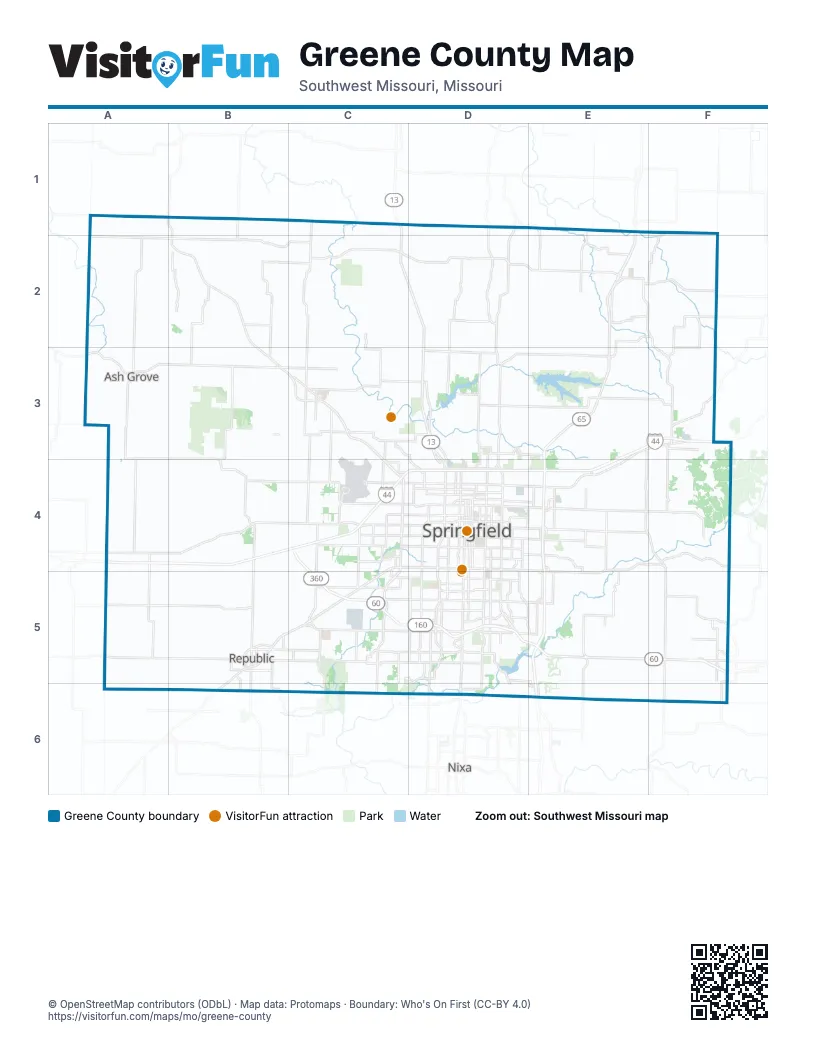
Street index of Greene County
Each street on the sheet and the grid squares it crosses.
- North Washington StreetB1, B2
- Main StreetA2
- West Main StreetA2, B2
- South Washington StreetB2
- East Old Mill RoadE2
- Maple StreetE2
- Old Mill RoadE2
- South Grove RoadE2
- West Old Mill RoadE2
- North Farm Road 223F2
- Calhoun AvenueA3
- East Boone StreetA3
- North Calhoun AvenueA3
- South Calhoun AvenueA3
- West Boone StreetA3
- Olympian BoulevardC3
- East Valley Water Mill RoadD3
- North Glenstone AvenueD3, D4
- North National AvenueD3, D4
- Peachtree LaneE3, E4, F4
- West Old Route 66E3, F3, E4
- East Old Route 66F3
- North InterchangeF3
- Captain Aaron J Eidem Memorial HighwayA4, B4, C4
- South Farm Road 81B4, B5
- Congressman Mel Hancock FreewayC4
- James River FreewayC4, C5, D5, E5
- North Airport BoulevardC4
- North West BypassC4
- Payne Stewart HighwayC4, D4, E4
- South West BypassC4, C5
- West Chestnut ExpresswayC4, D4
- West Division StreetC4, D4
- West Grand StreetC4, D4
- West Kearney StreetC4, D4
- West Sunshine StreetC4, D4, C5
- East Chestnut ExpresswayD4, E4
- East Division StreetD4, E4
- East Division Street/Route 66D4, E4
- East Grand StreetD4
- East Kearney StreetD4, E4
- East McClernon StreetD4
- East Norton RoadD4
- East Saint Louis StreetD4
- East Sunshine StreetD4, E4, E5
- East Trafficway StreetD4
- Memorial PlazaD4
- North Benton AvenueD4
- North Campbell AvenueD4
- North Grant AvenueD4
- North Jefferson AvenueD4
- North Kansas ExpresswayD4
- North Kentwood AvenueD4
- North Kimbrough AvenueD4
- North Scenic AvenueD4
- Park Central EastD4
- Park Central SquareD4
- Park Central WestD4
- South Campbell AvenueD4, D5, D6
- South Fremont AvenueD4, D5
- South Glenstone AvenueD4, D5
- South Grant AvenueD4
- South Jefferson AvenueD4
- South Kansas ExpresswayD4, D5
- South Kimbrough AvenueD4
- South Lone Pine AvenueD4, D5
- South National AvenueD4, D5
- South Scenic AvenueD4, D5
- West College RoadD4
- West College StreetD4
- West Norton RoadD4
- North Beaver RoadE4
- North Mulroy RoadE4
- Schoolcraft FreewayE4, E5
- West Elm StreetA5, B5, C5
- East Elm StreetB5, C5
- North Main AvenueB5
- South Main AvenueB5
- Old Wire RoadC5
- Plainview RoadC5, D5
- South Clarborne StreetC5
- West 3rd StreetC5
- West 4th StreetC5
- West Battlefield RoadC5, D5
- West Farm Road 182C5, D5
- West Republic RoadC5, D5
- East Battlefield RoadD5, E5
- East Briar StreetD5
- East Farm Road 182D5
- East Farm Road 188D5, E5
- East Primrose StreetD5
- East Republic RoadD5
- East Sunset StreetD5
- East Walnut Lawn StreetD5
- East Weaver RoadD5
- Kansas ExpresswayD5
- South Farm Road 137D5
- South Farm Road 141D5
- South Farm Road 163D5
- South Kissick AvenueD5
- West Farm Road 190D5
- West Plainview RoadD5
- West Primrose StreetD5
- West Sunset StreetD5
- West Walnut Lawn StreetD5
- West Weaver RoadD5
- South Blackman RoadE5
- South Mentor RoadE5, E6
- South Southwood AvenueE5, E6
- East Center StreetF5
- Farm-to-Market Road 186F5
- Marshall StreetF5
- South Farm Road 247F5
- West Center StreetF5
- Northeast Elm StreetB6
- East Riverbluff BoulevardE6
- Evans RoadE6
Things to do on the Greene County map
Places on the map
- Abbey Lane
- Aero Acres
- Allendale Estates
- Amazon STL3
- Arrowhead Estates
- Ash Grove
- Ashton Woods
- Augusta Hills
- Autumn Brook
- Barrington Park
- Battlefield
- Battlefield Estates
- Battlefield Mall
- Beechwood Heights
- Bent Tree
- Berkeshire Trails
- Betty & Bobby Allision Sports Town
- Birchwood Estates
- Bois d'Arc Conservation Area
- Bombs Away
- Bradford Estates
- Brentwood Estates
- Brentwood South
- Brentwood Terrace
- Briarwood
- Broadmoor Manor
- Brookside
- Bryn Mawr Heights
- BSB Tie Co INC
- Buc-ee's
- Cambridge Terrace
- Camelot Village
- Cardinal Crest
- Carefree Acres
- Carriage Park
- Carver Middle School
- Carver Place
- Castlewood Crest
- Catalpa East
Next to Greene County
- Nixa
© OpenStreetMap contributors (ODbL) · Map data: Protomaps · Boundary: Who's On First (CC-BY 4.0)