

Missouri map
Springfield map
About 170,596 people live here (Census Bureau, 2024 estimate). The sheet's index lists 300 streets; West Sunshine Street, Schoolcraft Freeway and James River Freeway cross the most grid squares. Things to do inside the boundary: Bass Pro Shops Outdoor World and Wonders of Wildlife National Museum & Aquarium.
Open the map (PDF, US Letter)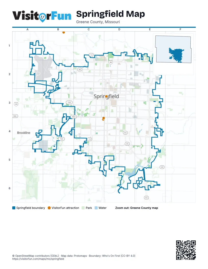
Street index of Springfield
Each street on the sheet and the grid squares it crosses.
- Schoolcraft FreewayE2, E3, E4, E5, E6
- James River FreewayA4, B4, C5, D5, E5
- Payne Stewart HighwayC2, D2, E2
- South Kansas ExpresswayC3, C4, C5
- South Campbell AvenueD3, C4, D4, C5, C6
- East Chestnut ExpresswayD3, E3
- West Chestnut ExpresswayB3, C3, D3
- West Sunshine StreetB3, C3, A4, B4, C4, D4
- South Glenstone AvenueD3, D4, D5
- East Battlefield RoadD4, E4
- East Kearney StreetD2, E2, F2
- South West BypassB3, B4
- North Kansas ExpresswayC1, C2, C3
- West Kearney StreetB2, C2, D2
- North Glenstone AvenueD1, D2, D3
- East Sunshine StreetD4, E4
- West Republic RoadB5, C5, D5
- East Republic RoadD5, E5
- North West BypassB2, B3
- West Battlefield RoadB4, C4, D4
- East Trafficway StreetD3
- North Mulroy RoadF1, F2
- North Beaver RoadF1, F2
- Kansas ExpresswayC5
- South National AvenueD3, D4, D5
- South Fremont AvenueD3, D4, D5, D6
- West Division StreetB2, C2, D2
- South Jefferson AvenueD3, D4, D5, D6
- South Scenic AvenueC3, C4, C5
- West Grand StreetB3, C3, D3
- South Lone Pine AvenueE3, E4, E5
- North Grant AvenueC1, C2, C3
- East Primrose StreetD4, D5
- East Sunset StreetD4, E4
- South Kimbrough AvenueD3, D4, D5
- East Grand StreetD3, E3
- North National AvenueD1, D2, D3
- East Division StreetD2, E2
- South Grant AvenueC3, C4
- North Airport BoulevardA2, A3
- West Walnut Lawn StreetC4, D4
- North Campbell AvenueD2, D3
- West Sunset StreetB4, C4, D4
- West College StreetB3, C3, D3
- North Benton AvenueD2, D3
- North Jefferson AvenueD2, D3
- East Norton RoadD1, D2
- West Norton RoadC2, D2
- East Division Street/Route 66D2, E2
- East Saint Louis StreetD3
- East Walnut Lawn StreetD4
- South Blackman RoadE4
- South Kissick AvenueD5, D6
- East McClernon StreetD1, D2
- East Briar StreetD5
- East Farm Road 188D6, E6
- East Weaver RoadD5
- West Primrose StreetC4, C5, D5
- North Kentwood AvenueD1, D2, D3
- West Weaver RoadC5, D5
- South Southwood AvenueE6
- West College RoadC3
- East Riverbluff BoulevardE6
- West Plainview RoadC5, D5
- North Scenic AvenueC3
- East Farm Road 182D5
- Evans RoadE6
- Park Central SquareD3
- Park Central EastD3
- South Farm Road 137C5
- North Kimbrough AvenueD3
- Park Central WestD3
- West Farm Road 182C5
- South Farm Road 163D5
- Memorial PlazaD3
- East Cherry StreetD3, E3
- West Mount Vernon StreetB3, C3, D3
- South Fort AvenueC3, C4, C5
- South Kansas AvenueC3, C4, C5
- West Nichols StreetB2, C2, D2
- East Bennett StreetD3, E3
- East Seminole StreetD4, E4
- East Catalpa StreetD3, E3
- South Luster AvenueD3, D4, D5
- East Blaine StreetD2, E2
- South Ingram Mill RoadE3, E4
- East Pythian StreetD2, D3, E3
- North Fremont AvenueD1, D2, D3
- South Golden AvenueC3, C4
- North Eastgate AvenueE2, E3
- North Broadway AvenueC2, C3
- South Eastgate AvenueE3, E4
- East Elm StreetD3, E3
- East Walnut StreetD3, E3
- West High StreetC2, D2
- North Summit AvenueD1, D2, D3
- South Oak Grove AvenueE3, E4
- East Commercial StreetD2, E2
- North Boonville AvenueD2, D3
- South Farm Road 115A4, B4, A5, B5
- West Olive StreetB3, C3, D3
- East Atlantic StreetD2, E2
- North Main AvenueC2, D2, C3
- South Barnes AvenueD3, D4
- West Atlantic StreetC2, D2
- East Dale StreetD2
- North Barnes AvenueD1, D2, D3
- West Seminole StreetB4, C4, D4
- West Elm StreetC3, D3
- West Bennett StreetC3, D3
- East Independence StreetD5, E5
- East High StreetD2
- North Le Compte RoadE2
- North Cedarbrook AvenueE1, E2, E3
- West Broadmoor StreetC4, D4
- West Chesterfield BoulevardC5
- North Packer RoadE2
- East Central StreetD3, E3
- North Washington AvenueD2, D3
- North Golden AvenueC2, C3
- South Cox RoadC4, C5
- North Fulbright AvenueC2, C3
- North Westgate AvenueB2, B3
- North West AvenueC2, C3
- North Sherman AvenueD2, D3
- North Clifton AvenueC2, C3
- West Commercial StreetB2, C2, D2
- South Mentor AvenueE4, E5
- South Charleston AvenueD5
- East Smith StreetD1
- West Smith StreetC1, C2
- East Olive StreetD3, E3
- East Valley Water Mill RoadD1, E1
- West Central StreetC2, C3, D3
- North Kansas AvenueC1, C2
- South Miller AvenueB3
- South Orchard Crest AvenueB3
- Farm Road 181E6
- South South AvenueD3
- West Lakewood StreetC5
- North Orchard Crest AvenueB2, B3
- East Galloway StreetD4, E4, E5
- South McCurry AvenueB3, B4
- West El Camino Alto DriveC5, D5
- South Enterprise AvenueD3, E3, D4
- Springfield Airport EntranceB2
- West Farm Road 136B3
- North Farm Road 171D1
- North Farm Road 123B2
- South Ingram Mill AvenueE3
- West Farm Road 156B4
- North Farm Road 139C1
- North Hilton AvenueC2, C3
- North Vernon AvenueD1
- North Miller AvenueB2, B3
- South Fort RoadC3, C4
- South Hilton AvenueC3
- South Farm Road 145C5
- South Zimmer RoadB3
- S. Innovation AvenueE6
- West Farm Road 94A1
- South Farm Road 135C4, C5
- East Mill StreetE3
- North Ingram Mill AvenueE3
- North John Q Hammons ParkwayD3
- East Galloway RoadE5
- North Farm Road 143C1
- Park Central NorthD3
- Park Central SouthD3
- South Delaware AvenueD3, D4, D5
- West Calhoun StreetB2, C2, D2
- South Kings AvenueD3, D4, D5
- West Madison StreetB3, C3, D3
- North Park AvenueC1, C2, C3
- West Chestnut StreetA3, B3, C3, D3
- South Broadway AvenueC3, C4, C5
- West State StreetB3, C3, D3
- West Walnut StreetB3, C3, D3
- South Weller AvenueD3, D4, D5
- South Roanoke AvenueD3, D4, D5
- East Portland StreetD3, E3
- South Holland AvenueD3, D4
- East Turner StreetD2, E2
- South Kentwood AvenueD3, D4, D5
- South Kickapoo AvenueD3, D4, D5
- West Lombard StreetB3, C3, D3
- West Lynn StreetB2, C2, D2
- South Ferguson AvenueC3, C4, C5
- West Catalpa StreetC3, D3
- South Nettleton AvenueC3, C4, C5
- East Linwood DriveD3, E3
- South Dollison AvenueD3, D4, D5
- South Newton AvenueC3, C4, C5
- North Missouri AvenueC2, C3
- South Stewart AvenueD3, D4, D5
- South Pickwick AvenueD3, D4
- North Robberson AvenueD2, D3
- East Lakewood StreetD5
- East Madison StreetD3, E3
- West Phelps StreetC3, D3
- East Cherokee StreetD4, E4
- North Eldon AvenueB2, B3
- South Fairway AvenueD3, D4, D5
- East Edgewood StreetD4, E4
- North Delaware AvenueD1, D2, D3
- West Harrison StreetB3, C3, D3
- East Lark StreetD5, E5
- East Stanford StreetD3, E3, E4
- South Glenn AvenueC3, C4, C5
- East Meadowmere StreetD3, E3
- North Franklin AvenueC2, C3
- West Brower StreetB3, C3, D3
- North Rogers AvenueD1, D2, D3
- East Evergreen StreetD2, E2
- North Johnston AvenueC2, C3
- North Fort AvenueC2, C3
- South Weaver AvenueC3, C4
- South Missouri AvenueC3, C4
- East Delmar StreetD3, E3
- West Webster StreetC2, D2
- North Prospect AvenueD1, D2, D3
- South Clay AvenueD3, D4, D5
- South Main AvenueC3, C4, C5
- North Weller AvenueD1, D2, D3
- East Pacific StreetD2, E2
- South Franklin AvenueC4, C5
- South Virginia AvenueD3, D4, D5
- West Scott StreetC2, D2
- North Nettleton AvenueC2, C3
- North Hillcrest AvenueC2, C3
- West Cherokee StreetC4, D4
- West Willard RoadB1, B2
- East Lombard StreetD3, E3
- East Locust StreetD2, E2
- North Lyon AvenueD2
- East Greenwood StreetD4, E4
- East Glenwood StreetD4, E4
- West Kingsley StreetC5
- South Maryland AvenueD3, D4
- East Woodland StreetD4, E4
- North Howard AvenueD1, D2
- North East AvenueD1, D2
- East Loren StreetD3, E3
- East Monroe StreetD3, E3
- South Robberson AvenueD3, D4, D5, D6
- East Broadmoor StreetD4, E4
- West Water StreetB3, C3, D3
- East Berkeley StreetD4, E4
- South Hillcrest AvenueC3, C4, C5
- East University StreetD3, E4
- West Hovey StreetB2, C2, D2
- East Mimosa StreetD4, E4
- South AvenueD3, D4, C5, D5
- East Montclair StreetD4, E4
- West Page StreetB3, C3, D3
- North Oak Grove AvenueE2, E3
- South Florence AvenueD3, D4
- East Rosebrier StreetD4, E4
- West Washita StreetB4, C4
- South Marlan AvenueD3, D4
- Alliance AvenueB2
- North Marion AvenueC1, C2, C3
- East Wayland StreetD4, E4
- East Cairo StreetD3, E3
- South Cedarbrook AvenueE3, E4
- North Douglas AvenueC2, C3
- South Westwood AvenueC4, C5
- West Talmage StreetA2, C2, D2
- South Brunswick AvenueE4, E5
- South Catalina AvenueE3, E4
- North Farm Road 115B1, B2, A3, B3
- East Crestview StreetD4, E4
- West Turner StreetC2, D2
- East Cambridge StreetD4, E4
- East Millwood DriveE6
- North Lexington AvenueC2, C3
- West Whiteside StreetC4, D4
- South McCann AvenueD3, D4, D5
- West Westview StreetC5
- East Belmont StreetD3, E3
- East Harrison StreetD3, E3
- East Kerr StreetD2, E2
- South Meadowview AvenueE3, E4, E6
- South Hampton AvenueD3, D4, D5
- West Thoman StreetC2
- South Farm Road 119B4
- South New AvenueC3
- Lake Springfield Park RoadD5
- South Dayton AvenueC4, C5
- South Oak AvenueE4, E5
- West Lasalle StreetC5
- South Market AvenueC3, D3, C4
- East Swallow StreetD5, E5
- North Kellett AvenueD1, D2
- West Meadowmere StreetC3, D3
- North Pierce AvenueD1, D2
- South Rogers AvenueD3, D4
- West Maplewood StreetC5
- North Warren AvenueC2, C3
- North Patterson AvenueE2, E3
Things to do on the Springfield map
Places on the map
- 66 Place
- Battlefield Mall
- Battlefield Market Place
- BSB Tie Co INC
- Buc-ee's
- Carver Middle School
- City Utilities
- Cooper Park
- Cox Medical Center South
- Cox North Hospital
- Downtown Airport
- Drury University
- Fassnight park
- Hazelwood Cemetery
- Hickory Hills Country Club
- Hillcrest High School
- James River Towne Center
- Killian Softball Complex
- Lake County Soccer Fields
- Lake Springfield
- Lake Springfield Park
- Lone Pine Park
- Long Term C
- Mediacom Tennis Stadium
- Mercy Hospital Springfield
- Mercy Rehabilitation Hospital Springfield
- Millwood Gold and Racquet Club
- Missouri State University
- Nathanael Greene Park
- Nature Center Park
- Ozarks Empire Fairgrounds
- Parkview High School
- Primrose Marketplace
- Silver Springs Park
- Springfield BNSF Railyard
- Springfield Golf & Country Club
- Springfield Plaza
- Springfield-Branson National Airport
- Valley Water Mill Park
- Valley Water Mill Pond
Next to Springfield
- Brookline
© OpenStreetMap contributors, Open Database License, openstreetmap.org/copyright · Map data: Protomaps · Boundary: Who's On First (CC-BY 4.0); U.S. Census Bureau