

Missouri map
St. Charles map
About 72,458 people live here (Census Bureau, 2024 estimate). The sheet's index lists 300 streets; Veterans Memorial Parkway, West Clay Street and Patrick J Bray Memorial Highway cross the most grid squares. Things to do inside the boundary: Fast Lane Classic Cars, Greater St. Charles Visitor Center and Historic Main Street St. Charles.
Open the map (PDF, US Letter)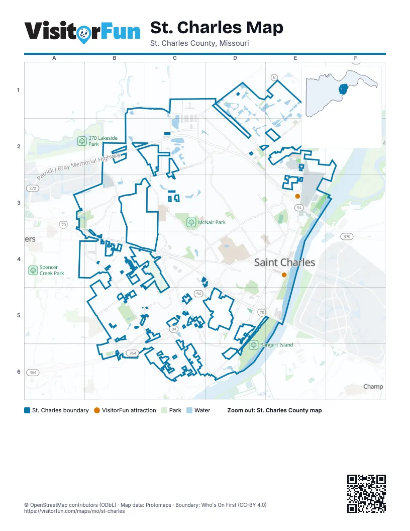
Street index of St. Charles
Each street on the sheet and the grid squares it crosses.
- Patrick J Bray Memorial HighwayB2, C2, D2, E3
- South First Capitol DriveD4, C5, D5, B6
- Veterans Memorial ParkwayA3, A4, B4, C4, D4, D5
- Discovery BridgeE3
- North Third StreetE2, E3, E4
- Muegge RoadB4, B5, C5, B6
- First Capitol DriveD4, E4
- South Fifth StreetE4, D5, E5
- Boone's Lick RoadD4, D5, E5
- Harry S Truman BoulevardB2, B3
- North Fifth StreetE3, E4
- North Second StreetE3, E4
- Clark StreetD4, E4
- Cave Springs RoadB3, B4
- Tecumseh StreetE3
- Lakeside Park DriveB2
- Zumbehl RoadC3, C4, C5
- West Clay StreetA3, B3, B4, C4, D4
- Elm Point Industrial DriveD1, C2, D2, C3
- Elm StreetC2, D2, D3, D4
- South Old Highway 94B5, C5, B6
- Mel Wetter ParkwayE3
- Friedens RoadC5, D6
- Little Hills ExpresswayD2, E2, E3
- Hackman RoadB5, B6
- South River RoadD5, D6
- Mueller RoadC1, D2
- New Town BoulevardC1, D1, C2
- North Kingshighway StreetD4, E4
- Arena ParkwayC6, D6
- South Second StreetE4, E5
- Pralle LaneC5, C6
- McClay RoadB5, B6
- North Saint Peters ParkwayB6
- Randolph StreetE4
- South Kingshighway StreetD4
- Heritage CrossingB6
- South Saint Peters ParkwayB6
- Droste RoadC3, C4, D4
- West Randolph StreetD2, D3, E3, E4
- Boschertown RoadE1, D2, E2
- Ehlmann RoadA3, B3, C3
- North Duchesne DriveD3, E3
- Graystone DriveB5, C5
- South Main StreetE4, D5, E5
- Huster RoadC1, C2
- Country Club RoadB4, C4, B5
- Fox Hill RoadD2, E2
- North Outer RoadD4, D5, B6
- South Duchesne DriveD3, C4, D4
- Fountain Lakes BoulevardC2
- Hemsath RoadC5, C6
- Fairgrounds RoadD5, D6
- Pundmann ParkwayC4, C5
- Jefferson StreetD4, E4
- Bluestone DriveC5, C6
- Riverside DriveE4, E5
- Convention Center BoulevardD5
- Olive StreetE3, E4
- Ameristar BoulevardD5, E5
- Old Muegge RoadB4
- Tree Top DriveB4
- Campus DriveC4
- Mexico RoadB4
- West Adams StreetD2, D3, D4
- Sun Lake DriveC4
- Talbridge WayC5, D5
- Park AvenueD3, E4
- North Fourth StreetE3, E4
- North River RoadF2, E3, F3
- Charlestowne Village DriveD2
- Tompkins StreetD4, E4
- Granger BoulevardD1, E1
- Elm Point RoadC2, D2
- Kettering DriveB5
- Sibley StreetD3, D4
- Lindenwood AvenueE3, D4, E4
- Charlestown Place DriveE1, E2
- Hayford RoadB2, C2, C3
- Plaza WayC4
- Norwich DriveC3, D3, C4
- North Benton AvenueE3, E4
- Headland DriveD3
- Hempstead StreetD1, E1
- Concordia LaneD3
- Sherman Park DriveC5, D5
- Carriage CrossingE2
- Perry StreetD4, E4
- Jackson StreetD4, E4, C6
- Madison StreetD4, E4
- Canal StreetD1
- Yale BoulevardC3, D3, C4
- Gallaher AvenueD3, E3, E4
- Mayer DriveC4, D4
- Riverchase ParkwayB3
- Westminster DriveD3
- Sandfort Farm DriveB3, B4
- Rebecca DriveD3, D4
- Monroe StreetD4, E4
- South 6th StreetD4, E4, D5
- Autumn Wood DriveB5
- Hawthorn AvenueD3, E3
- Hastings WayC2, D2, C3
- South Pam AvenueD3, D4
- Clarendon LaneC2, C3
- Adams StreetD4, E4
- Elmwood DriveD3
- Old Friedens RoadC5, D5
- Summer Glen LaneE1
- Cypress DriveD3
- North 6th StreetE3, E4
- Pike StreetD4, E4
- Cunningham AvenueD4, D5
- Brighton Park DriveA4, B4
- Compton ParkwayA3, B3
- Runnymede DriveC2, C3
- Palisades DriveE1
- Cole BoulevardC3, D3, C4
- McDonough StreetD4, E4, E5
- Trail of SunbrookB3
- Brookwood CircleB3
- Cottonwood DriveD2, E2
- Country Club Plaza DriveC5
- Mockingbird DriveD3
- Truman Terrace DriveB3
- South Benton AvenueD4, E4, D5
- North Canal WayD1
- North 7th StreetE3, E4
- North Main StreetE3, E4
- Indian Hills DriveD3
- South Fourth StreetE4, E5
- Bogey Estates DriveB5, C5
- Saint Charles AvenueD4
- Shorewinds TrailC5, D5
- Find Your Roar DriveD4
- Burning Tree LaneC5
- Washington StreetD4, E4
- North MainE3
- Hunters Ridge RoadC3, D3
- Eagle Forest DriveC6
- Water StreetD4, E4, E5
- Mary Easton CircleD4
- Bentwater PlaceD2, E2
- Elmhurst DriveD3
- Spring Mill Estates DriveB5
- Thrush DriveC3, D3
- Lake Forest DriveC3
- New Town Lake DriveD1, E1, E2
- Marr LaneB6
- Spring DriveB4
- Riverview LaneE3
- Covington ParkwayA3, B3
- Charwood StreetC4, D4
- Charlestowne Crossing DriveE2
- Lions One Roar DriveD4
- Huntington ParkwayC3
- Deergrass DriveC5
- McNair Park DriveC3
- Island Harbor DriveE1, E2
- Cog Wheel StationD2, E2
- Pompano LaneE1
- Southern Oaks DriveD5
- Sandfort LaneB3, B4
- Fountainview DriveA4, B4
- Eagle Cove LaneC4, C5
- James Butler WayD4
- Arpent AlleyD1
- Lynnbrook DriveC4, C5
- Remington BoulevardB4
- Arpent StreetD1
- Summitview DriveC5
- Devilla TrailE2
- Point West BoulevardB3, B4
- Ridgeview DriveD2, D3
- North 8th StreetE3, D4, E4
- Pine StreetE3, D4, E4
- Kunze DriveC6
- Scenic Cove LaneC6
- Wayfair LandingE1
- Lions Pride ParkwayD4
- Principia AvenueC3, D3
- Wild Goose RunB4, B5
- Ruth DriveC3, C4
- Towerbridge PlaceD5
- Presswick LaneC5
- Shadow Wood DriveC4, B5, C5
- Decatur StreetE4
- Ken DriveD2, D3
- Whitegate LaneC4
- Hackman Estates DriveB5
- Canary LaneC3, D3
- Forest AvenueD4
- Barter StreetE1
- Broad StreetD1
- Santa Fe StreetC5
- Fountain Lakes Industrial DriveC2
- Hawning RoadE2, F2
- Shady Oak DriveB3
- Pleasant Valley DriveC5
- Fountainview CircleA4, B4
- Diekamp Farm TrailB5
- Maple Tree DriveB5
- Chestnut Oak DriveD5, D6
- Silvertrail DriveE2
- Tamarack DriveD2, E2
- Rue Royale StreetD1
- Apricot DriveE2
- Kandahar DriveB4
- Lancaster DriveD2, D3
- Morgan StreetE4
- Spring AvenueD4
- Olde Court RoadC6, D6
- Lakeshore DriveD5
- Franklin StreetE4
- South 8th StreetD4
- Fine Arts DriveD4
- Sundrop DriveC5
- Houston StreetD4, E4
- Sturbridge DriveD5, D6
- Timberidge DriveB4, B5
- Montclair Tower DriveD6
- Glenco DriveD4
- Sundowner DriveB4, B5
- Beale StreetD5
- Woodbriar LaneB5
- Florine BoulevardB5
- East Governor PlaceC3
- Double Eagle DriveB5
- Cambrian WayC3
- Hineman DriveC3
- Scherer ParkwayC5
- Warwick DriveC3
- Pinedale DriveC4
- Spring Mill CreekB5
- Brook Hill LaneB5
- Deerfield DriveC2
- Greenleaf DriveB4
- Westborough DriveC3
- Blanche DriveC6
- Nathan AvenueD4
- North DriveE2
- Harvest Ridge DriveC6
- Willow Oak DriveD5
- Tuscany Trace DriveC6
- Basket Oak DriveD5
- Lake Forest LaneC3
- Clock Tower SquareD5
- Santa Monica StreetC5
- Sunny Meadows DriveB5
- River Edge DriveC5
- Lake CourtC4
- Suntan DriveD1
- Abbydale DriveB4
- Cherokee LaneD3
- Regency ParkwayC4
- Berlekamp DriveB4, C5
- Honey Locust LaneC5
- Prairie Haute DriveD4
- Park CourtC4
- Diekamp LaneC5
- Chargene StreetD4
- Santa Rosa StreetC5
- Bass Pro DriveD5
- Lawrence StreetE4
- Willow TrailB4, B5
- Woodlawn DriveD4, D5
- Blanchette DriveD3
- Hughes LaneE2
- Simeon BunkerE1, E2
- Holiday LaneD3
- Starkville StreetD1
- Banbury DriveB4
- Vine StreetE3, E4
- Lee DriveD3
- Country Bluff DriveE2, E3
- South 7th StreetD4, E4
- Saddleridge DriveE2
- Mango DriveE2
- Oakleigh Park LaneB5, B6
- Cascades DriveD5
- Exchange DriveC5, C6
- Oak AvenueD4
- South Third StreetE4, E5
- Depot LaneE3
- Dyess StreetD1, D2
- King DriveC4
- Kristopher Bend DriveB4
- Walters WayC5
- Boone AvenueD4
- Hollow BrookC5
- Riverine DriveD5, D6
- Little Hills Industrial BoulevardE3
- Calhoun DriveD2, E2
- Winding Glen DriveB5
- Ford LaneC5
- Salem DriveC2
- Chartom Mar DriveC4, D4
- Talbridge SquareD5
- La Brea DriveB6
- Olsney DriveB4
Things to do on the St. Charles map
Places on the map
- Arpent Lake
- Bangert Island
- Beach District
- Beach Lake
- Big Lake
- Blanchette Park
- Bogey Hills Plaza
- Boone's Lick Park
- Cave Spring Golf Center
- Covington
- Eco Park
- Fox Hill Park
- Foxborough Estates
- French District
- Frontier Park
- Gateway District
- Gateway Lake
- Island District
- Kluesner Lake
- Lou Brock Sports Complex
- Mark Twain Village
- McNair Park
- Moore Lake
- Nantucket Place
- Oak Grove Cemetery
- Regency Square 2
- Saint Charles
- Saint Charles Soccer Complex
- Skate Park Lake
- South Lake District
- ST Charles Ecopark
- St. Charles Memorial Gardens
- Streets of St. Charles
- Sunnydale Mobile Home Park
- Suntan Lake
- The Villages at Sandfort Farm
- Theatre District
- Truman Terrace
- West Lake District
- Wndsor Estates
Next to St. Charles
- Champ
© OpenStreetMap contributors (ODbL) · Map data: Protomaps · Boundary: Who's On First (CC-BY 4.0)