

Mississippi map
Lee County map
About 83,012 people live here (Census Bureau, 2024 estimate). The sheet's index lists 300 streets; Natchez Trace Parkway, East Main Street and Main Street cross the most grid squares. Things to do inside the boundary: Brice's Cross Roads National Battlefield Site, Elvis Presley Birthplace and Mall at Barnes Crossing.
Open the map (PDF, US Letter)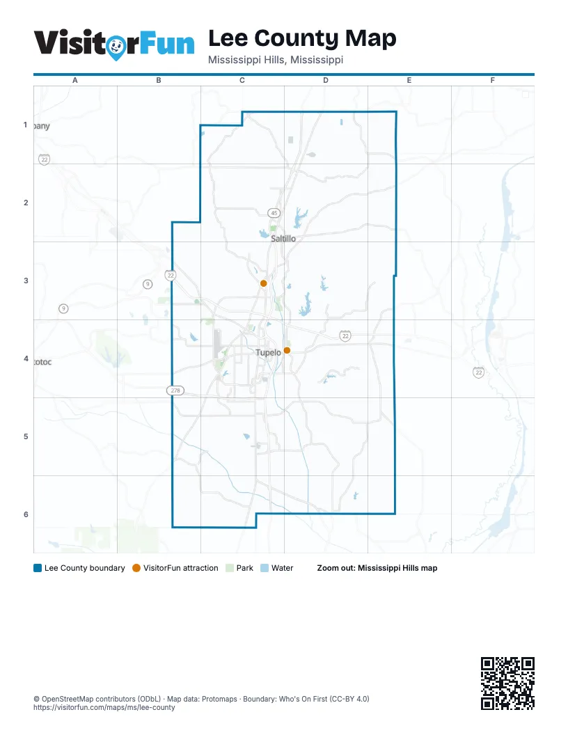
Street index of Lee County
Each street on the sheet and the grid squares it crosses.
- Martin Luther King DriveC4, C5, C6
- Corridor VB4, C4, C5
- McCullough BoulevardB3, C3, C4
- Martin Luther King, Junior DriveC4, C5
- Natchez Trace ParkwayD2, E2, C3, D3, C4, B5, C5
- West Main StreetD1, B4, C4, D6
- South Green StreetC4, C5
- East Main StreetD1, C4, D4, C5, D6
- Old Highway 6B4
- Union AvenueD5, D6
- Mississippi Highway 363D2, E2
- State Park RoadD4
- Road 814C5, D5
- County Road 520C5, D5
- Bethany RoadC1, D1
- Main StreetD2, D4, C5, D5, D6
- North Gloster StreetC3, C4
- Noah Curtis StreetC5, C6
- South Gloster StreetC4, C5
- State Highway 371E4, E5
- Mississippi Highway 145C3
- South 4th StreetD1
- Briar Ridge RoadD4
- Mobile StreetC2, D2
- South Raymond AvenueC5
- East Clayton StreetD1
- Will Robbins HighwayD6
- Central StreetD5
- Raymond AvenueC5
- State Highway 6D6
- North Main StreetD2
- County Road 506B5, B6, C6
- Birmingham Ridge RoadC2, C3
- County Road 1498D3, E3
- Old Saltillo RoadC3, D3, D4
- Palmetto RoadB5, C5
- County Road 251C2
- County Road 833C1, D1, D2
- West Jackson StreetC4
- County Road 2578E1, D2, E2
- Cliff Gookin BoulevardC4
- County Road 1205D5, D6
- South Eason BoulevardC4, D4
- County Road 231C1, C2
- Chesterville RoadB4, C4
- Coley RoadC3, C4
- West Barnes Crossing RoadC3
- Beech Springs RoadC3
- South Thomas StreetC4, C5
- North Veterans BoulevardD4
- Richmond RoadD5, E5
- Lawndale DriveC4
- South Veterans BoulevardC4, D4
- County Road 900B5, C5
- Road 185B5, C5
- Auburn RoadD3, D4
- North Green StreetC4
- Green Tee RoadC5
- Road 931D3, D4
- North 3rd AvenueC2, D2
- Barnes Crossing RoadC3, D3
- Road 659C5
- Bryson StreetD2
- Graham DriveC4, C5
- County Road 783C2
- Maple RoadD6
- Richmond-Nettleton RoadD5, E5
- Lumpkin AvenueC4
- County Road 771C5
- Clayton AvenueC4
- North Eason BoulevardD4
- County Road 1600B3
- Country Club RoadC4
- Euclautubba RoadC2
- Kirkwood RoadC4
- County Road 2902C1
- Auburn Road / County Road 931D3, D4
- Willie Moore RoadC4, C5
- Blemingham Ridge RoadC2
- County Road 711C5
- Cdf BoulevardC5
- West Eason BoulevardC4
- Endville RoadB3, C3
- North Front StreetC4
- Pulltight RoadC2
- County Road 2446C2, D2
- South Spring StreetC4
- County Road 1350B4
- Highway 2446C2
- East Franklin StreetC4
- East Jackson StreetC4
- City Point RoadC5
- North Thomas StreetC4
- Monument DriveC4
- East Elizabeth StreetC4
- Clark BoulevardC4
- Bryan DriveC4
- Crossover RoadC4
- South 3rd AvenueD1, D2, C3, D3
- Kincannon StreetC4
- South President AvenueC4
- West Elizabeth StreetC4
- Shell StreetC4
- Clark StreetC4
- South Front StreetC4
- Tupelo High School DriveC4
- Sims Gin RoadB4
- County Road 5011D1
- County Road 1451D3, E3, E4
- County Road 885D3, D4
- Mount Vernon RoadB3, C3, C4
- County Road 821D2, D3
- County Road 503C1, C2
- Old Highway 45C2, C3, C6, D6
- County Road 300B6, C6
- County Road 1409D3, D4, E4
- County Road 1310D4, E4
- County Road 154B6, C6
- County Road 2346D2, E2, D3, E3
- County Road 1389D2, D3
- Road 1349D3, D4
- Pratt RoadD1
- County Road 1277D6, E6
- County Road 122D6, E6
- County Road 598D5, E5
- County Road 1303D2, E2
- County Road 1970D2, E2, E3
- County Road 54B6, C6
- County Road 452D5, E5
- County Road 2788D1, E1
- Old Union RoadC5
- Road 41B4, B5
- County Road 261C5
- County Road 683C2
- County Road 2538D2, E2
- Road 1233D5
- Cemetery RoadD1, D5, C6
- County Road 681C2, C3
- County Road 295B5, C5, C6
- County Road 1650E3
- County Road 813D2
- Road 373C5
- County Road 1149D5, D6
- County Road 2350D2, E2
- County Road 931D3, D4
- Deer Park RoadD3, D4
- County Road 601C1, C2
- County Road 1463E5, E6
- Euclatubba RoadC2
- County Road 183B3
- County Road 1199D5
- Mountain Leader TrailD3
- County Road 805C5, C6
- Road 878D5, E5
- Road 1766D3
- Road 461C3
- County Road 1124D4, E4
- County Road 2878D1
- County Road 1057D3
- County Road 2442D2
- County Road 870D5
- Road 1282D4
- County Road 901C5, D5, D6
- Road 1B2, B3
- Mitchell RoadC4
- Road 1948B2, C2, B3
- County Road 115B6
- County Road 1503E1, E2
- County Road 417C1, C2
- County Road 653C3
- County Road 1093D5
- County Road 1543E3
- County Road 1740B3, C3
- Road 1009D4
- County Road 1411E5
- County Road 1213D1
- County Road 1201D5
- County Road 1439D4, E4
- Lakeshire DriveC3, C4
- County Road 1597E5
- County Road 855D5
- Purnell RoadB4, C4
- Elvis Presley DriveD4
- County Road 599C2
- Trice StreetC4, C6, D6
- County Road 684B5, C5
- County Road 1275D1, D2
- County Road 1325D3
- County Road 1203D5, D6
- County Road 1948B2, C2, B3
- County Road 2890D1, E1
- County Road 141B2, B3
- Butler RoadB4, C4
- County Road 1113D4, D5
- County Road 484C5, D5
- Dr 1227D3
- Industrial Park RoadC3
- County Road 1255D2
- County Road 501C5, C6
- Oakview DriveD4
- County Road 331C1
- Road 830D5
- County Road 2216D2, E2
- County Road 395C2, C3
- King RoadB3
- County Road 151B4, C4, B5
- County Road 1727D2, D3
- Sandhill AvenueD1
- Road 1581E4, E5
- County Road 1351D3
- County Road 41B3, B4
- County Road 2432D2
- County Road 1178E4
- County Road 1029D3, D4
- County Road 831D3
- North Madison StreetC4
- County Road 109B6, C6
- County Road 911D1, D2
- County Road 951D2
- County Road 1279D4
- County Road 1400E4
- North Hillsdale DriveD4
- West RoadD3, C5
- County Road 2790C1, D1
- County Road 1529E1
- County Road 590C5
- Group Camp DriveD4
- McComb AvenueC3
- County Road 1023 SouthD5
- Cotton Gin LaneC3
- County Road 1599E1, E2, E4
- President AvenueC4
- Bissel RoadC4
- County Road 301C6
- County Road 401C6
- County Road 1390D4
- County Road 697C1
- County Road 47B5
- County Road 1500B3
- County Road 2848C1
- County Road 752B5
- Ford AvenueD1, D2
- County Road 2256E2
- Locust LaneB4, C4
- County Road 263C2
- County Road 404B5
- County Road 1438D4
- Safari Drive ThroughC4
- Wilson StreetC4, D4
- County Road 1900D3
- County Road 773C2, D2
- County Road 341C1, C2
- County Road 1001D4
- Edison AvenueD2
- Sonny Tucker RoadE5
- County Road 1836B3, C3
- County Road 646D5
- County Road 1130E4
- Southern Heights RoadC4, C5
- Countrywood RoadB3, B4
- Old Payne PlaceC2
- Grisham StreetD1
- South Feemster Lake RoadD4
- County Road 1399D3
- Mattox RoadC5
- Bissell RoadC4, C5
- County Road 1151D6
- Walsh RoadB3, B4
- Old Town CircleC3
- County Road 819C5, D5
- County Road 1742D3
- Road 203B3
- Fillmore DriveC4
- South StreetD1, C3, C6
- County Road 1551E3, E4
- County Road 2776D1, E1
- Road 51B5
- Air Park RoadC4
- Road 325C5
- Mall CircleC3
- County Road 1802D3
- North StreetC2, D2, C4, C6
- Old District Line RoadD5
- County Road 2250B2, C2
- County Road 746D5
- County Road 1147D4
- County Road 1830E3
- Oak Park DriveC4
- Springlake DriveC4
- County Road 661C1
- South Canal StreetC4, D4
- Turner Park RoadC2, C3
- Brooks RoadC3
- Old Belden CircleC3
- Road 53B4
- Village Lake DriveC4
- Hancock RoadB4
- County Line RoadE3, E4
- Poplar StreetC4, D4
- County Road 199B4, C4, B5
Things to do on the Lee County map
Places on the map
- Army Aviation Support Facility
- Baldwyn
- Ballard park
- Ballard Park Lake
- Bel-Air Golf Course Tupelo
- Big Oaks Colf Course
- Cadence Bank
- Carver High School
- Dogwood Hill Circle
- Downtown Tupelo Post Office
- Elvis Presley Lake
- Friendship Cemetery
- Glenwood Cemetery
- Green Street Elementary School
- Gumtree Park
- Guntown
- Historic Downtown Tupelo
- Joyner Avenue School
- Lake Lamar Bruce
- Lake Piomingo
- Lake Sequoyah
- Lee Memorial Park
- Legion Lake
- Mall at Barnes Crossing
- Music Bend Trail
- NMMC Women's Hospital
- North Mississippi State Hospital
- Plantersville
- Saltillo
- Shannon
- Spring Lake
- Tombigbee State Park
- Tupelo
- Tupelo Country Club
- Tupelo Furniture Market
- Tupelo High School
- Tupelo National Fish Hatchery
- Verona
- Veterans Park
- West Fraser - Gun Town Mill
Next to Lee County
- Pontotoc
© OpenStreetMap contributors, Open Database License, openstreetmap.org/copyright · Map data: Protomaps · Boundary: Who's On First (CC-BY 4.0); Quattroshapes (CC BY 2.0)