

Montana map
Flathead County map
About 114,527 people live here (Census Bureau, 2024 estimate). The sheet's index lists 300 streets; South Fork Road, North Fork Road and West Side Road cross the most grid squares. Things to do inside the boundary: Flathead Lake Alpine Coaster, Flathead Lake Charters and Flathead Lake Monster Charters.
Open the map (PDF, US Letter)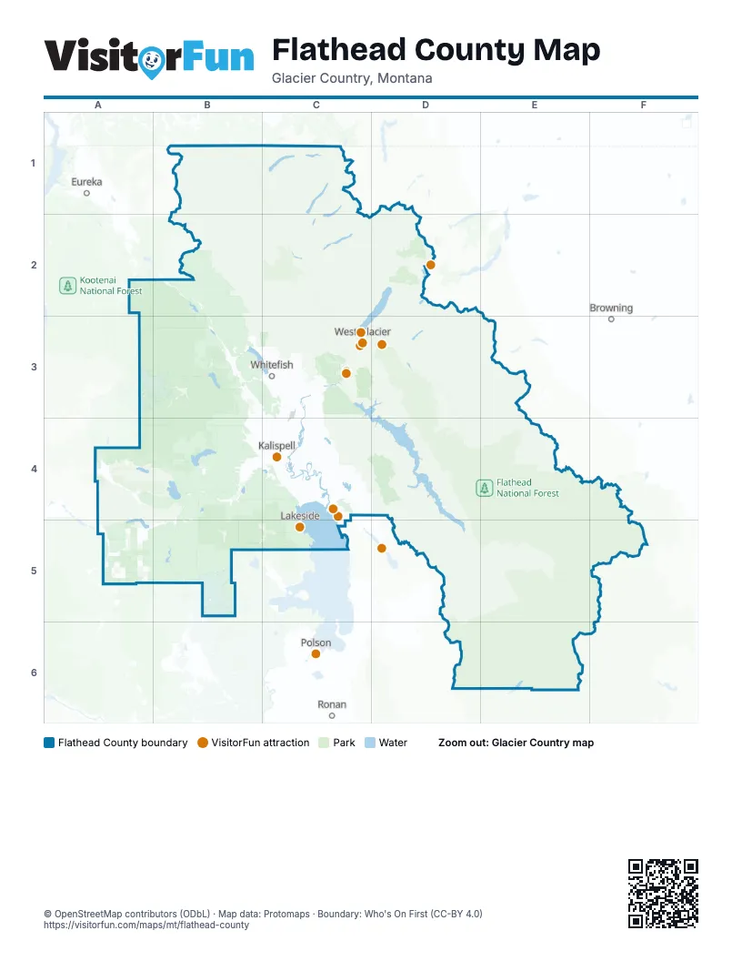
Street index of Flathead County
Each street on the sheet and the grid squares it crosses.
- Kalispell BypassC4
- US 93 SouthC3, C4
- US 93 NorthC3, C4
- West Reserve DriveB4, C4
- Three Mile DriveB4, C4
- East Idaho StreetC4
- West Idaho StreetB4, C4
- 9th StreetC3
- La Salle RoadC4
- Spokane AvenueC3, C4
- East 2nd StreetC3
- Sunset BoulevardC3, C4
- South Main StreetC4
- North Main StreetC4
- State Highway 35C4
- West 2nd StreetC3
- South Fork RoadC3, D3, D4, D5, E5
- Going-to-the-Sun RoadD2, C3, D3
- Farm To Market RoadB3, B4, C4
- Camas RoadC2, C3
- Whitefish Stage RoadC3, C4
- Foothill RoadC4
- Columbia Falls Stage RoadC3, C4
- Helena Flats RoadC3, C4
- East Lakeshore DriveB3, C3
- Hodgson RoadC3
- Hungry Horse Dam RoadC3
- Echo Lake RoadC4
- Lake Blaine RoadC4
- Rose CrossingC4
- Old US 2C3
- Willow Glen DriveC4
- Conrad DriveC4
- River RoadC3, C4
- East Reserve DriveC4
- North Meridian RoadC4
- Wisconsin AvenueC3
- Baker AvenueC3
- Hutton Ranch RoadC4
- Shady LaneC4
- Old Reserve DriveC4
- Central AvenueC3
- Glacier Airport RoadC3
- Reserve LoopC4
- Nucleus AvenueC3
- 7th Avenue East NorthC3, C4
- North Nucleus AvenueC3
- West 13th StreetC3
- Allison Fifield MemorialC4
- Whitefish River BridgeC4
- North Fork RoadB1, C1, C2, C3
- West Side RoadC3, C4, D4, D5
- Pleasant Valley RoadA4, B4
- Ashley Lake RoadB4
- Star Meadow RoadB3
- Trail Creek RoadB1
- Griffin Creek RoadB4
- Lost Prairie RoadA4
- Lower Valley RoadC4
- Trumble Creek RoadC3, C4
- Tally Lake RoadB3
- North Ashley Lake RoadB4
- West Valley DriveB3, B4
- National Forest Development Road 538B3, B4
- National Forest Development Road 538BA3, B3, B4
- Smith Lake RoadB4
- Thompson River RoadA5
- Good Creek RoadB3
- McMannamy DrawB4
- Foys Lake RoadB4, C4
- National Forest Development Road 113A3, B3
- Church DriveB4, C4
- Mountain Meadow RoadB3, B4
- Rhodes DrawB4
- Stillwater RoadC4
- West Springcreek RoadB4
- Blankenship RoadC3
- La Brant RoadC4
- Airport RoadC4
- Holt Stage RoadC4
- East Edgewood DriveC3
- Big Mountain RoadC3
- Belton Stage RoadC3
- Tamarack LaneC3
- Birch Grove RoadC4
- North Somers RoadC4
- Jellison RoadC3
- National Forest Development Road 913B3
- Star Meadows RoadB3
- Swan River RoadC4
- Whalebone DriveB4, C4
- Kelley RoadC3
- Monegan RoadC3
- Batavia LaneB4
- Foys Canyon RoadC4
- Four Mile DriveB4, C4
- Twin Bridges RoadB3
- Lodgepole RoadB3
- Kila RoadB4
- Braig RoadC3
- Fox Farm RoadB4
- Bachelor Grade RoadC4
- Blanchard Lake RoadB3, C3
- 3rd Avenue EastC3, C4
- Halfmoon RoadC3
- Dillon RoadC3
- Mennonite Church RoadC4
- Wishart RoadC3
- Two Mile DriveB4, C4
- Voerman RoadC3
- Karrow AvenueC3
- Tetrault RoadC3
- 2nd Avenue WestC3, C4
- Park AvenueC3, C4
- 1st Avenue WestC3, C4
- 4th Avenue WestC3, C4
- 6th Avenue WestC3, C4
- 5th Street WestC3, C4
- Somers RoadC4
- Talbot RoadC3
- 1st Avenue EastC3, D3, C4
- South Hilltop RoadC3
- 7th Street WestC3, C4
- 11th Street WestC3, C4
- 4th Avenue EastC3, C4
- 2nd Street WestC3, C4
- 5th Avenue WestC3, C4
- 4th Street WestC3, C4
- West Evergreen DriveC4
- 3rd Street WestC3, C4
- Olney Loop RoadB3
- 7th Avenue WestC3, C4
- Meadow Lake BoulevardC3
- 4th Avenue West NorthC3, C4
- J P RoadC3
- National Forest Development Road 912B4
- Woodland AvenueC4
- East Evergreen DriveC4
- Truck Route RoadC3
- Outside North Fork RoadB1, C2
- Edgewood PlaceC3
- Pioneer RoadC3
- East Oregon StreetC4
- 4th Avenue East NorthC3, C4
- 1st Avenue East NorthC3, C4
- Cemetery RoadC4
- State Park RoadC3
- 3rd Avenue East NorthC3, C4
- 5th Street EastC3, C4
- West 7th StreetC3
- 4th Street EastC3, C4
- West Center StreetC4
- 5th Avenue West NorthC4
- Walsh RoadC3
- 2nd Avenue West NorthC3, C4
- Big Horn DriveB4
- West Lakeshore DriveC3
- 3rd Street EastC3, C4
- 2nd Street EastC3, C4
- Flathead DriveC4
- West Wyoming StreetC4
- 11th Street EastC4
- Phanco LaneB4
- Commerce StreetC3, C4
- Sunnyside DriveC4
- Brunner RoadC3
- Derns RoadB4
- South Meridian RoadC4
- Sunnyview LaneC4
- 7th Avenue West NorthC4
- 18th Street EastC4
- Lake Five RoadC3
- East Center StreetC4
- Woodland Park DriveC4
- East 8th StreetC3
- Lion Mountain RoadB3, C3
- Railroad StreetC3
- Best WayC3
- Garden DriveC4
- Cosway RoadC4
- Park PlaceC3, C4
- Old Steel BridgeC4
- 19th StreetC3
- 17th Street WestC4
- Inside North Fork RoadB1, C1, C2, C3
- Browns Meadow RoadB4, B5
- Forest Road 316C2, B3, C3
- Upper Whitefish RoadB2, B3
- Red Meadow Creek RoadB2, C2
- Upper Dayton Creek RoadB5, C5
- Fs2908A3, B3
- Spotted Bear River RoadE5
- Red Gate RoadB5
- Blacktail RoadC5
- Bill Creek RoadB3, B4
- National Forest Development Road 60A3, B3
- Forest Road 317B2, C2
- Lower Lost Prairie RoadA4, B4
- National Forest Development Road 910B2, B3
- Patrick Creek RoadC4
- Cyclone Creek Moran Creek RoadC2
- Sunday Creek RoadA2, B2, A3
- Forest Road 2826D5, E5
- Truman Creek RoadB4, B5
- Whale Creek RoadB1
- Lower Whitefish RoadB2, B3
- Emmons Creek RoadB4, C4, B5, C5
- Mount Creek RoadB4, B5
- Hay Creek RoadB2, C2
- Old Fort Steele TrailB2, B3
- Forest Road 803C2, C3
- Skyland RoadE4
- National Forest Development Road 313B3, B4
- Desert Mountain RoadC3, D3
- Middle RoadC3, C4
- Crossover RoadB5
- Hubbart Dam RoadB5
- Trail CreekC4
- Mount Creek Potter Creek RoadB4, B5
- Martin Camp RoadB3
- National Forest Development Road 9784B3
- National Forest Development Road 2904B3
- National Forest Development Road 5347B4
- Ruple Meadow RoadB2
- K M Ranch RoadB3, C3
- Cramer Creek RoadC4, C5
- Antice RoadB2
- Haywire GulchB4
- National Forest Development Road 351AB3
- National Forest Development Road 3710A2, A3, B3
- National Forest Development Road 2956B3
- Cromwell Creek RoadB5
- Riverside RoadC4
- Wild Bill CreekB5
- National Forest Development Road 9612B4
- National Forest Development Road 2886B3, B4
- National Forest Development Road 2925A3, B3
- National Forest Development Road 2892A3, B3
- National Forest Development Road 60AA3, B3
- Jewel Basin RoadC4, D4
- National Forest Development Road 9897B3
- Sickler Creek RoadB4, B5
- National Forest Development Road 313BB4
- Moose Creek RoadB1, C1, B2
- National Forest Development Road 5344B4
- Fitzsimmons RoadB2
- Teakettle RoadC3
- Haskill Basin RoadC3
- Rogers Lake RoadB4
- Hornet Creek RoadB1
- National Forest Development Road 1649B2, B3
- ACM Road SouthA5
- Bowman Lake RoadC1, C2
- Lost Creek DriveB3, B4
- National Forest Development Road 2875B3
- National Forest Development Road 5373B4, B5
- Pleasant View RoadA4
- Steel Bridge RoadC4
- National Forest Development Road 313AB3
- Fs6770A5
- Coal Creek RoadB2, C2
- Logan Creek RoadB3, B4
- Evers Creek RoadB3
- Lupper RoadB3
- National Forest Development Road 3791B2, B3
- Oettiker Creek RoadB3
- Grizzly SpurC3
- National Forest Development Road 2903B3
- National Forest Development Road 60DB3
- National Forest Development Road 2926B3
- Forest Road 315B2, C2
- Flathead Mine RoadB5
- Skyles LaneB3
- Fs11232B3
- Forest Road 5207B2, C2
- Island Lake RoadA4
- National Forest Development Road 915BB5
- Forest Road 549E5
- National Forest Development Road 9539B4
- Swan Hill DriveC4
- Peter's Ridge RoadC4
- Farm RoadC4
- National Forest Development Road 915B5
- Battle Butte RoadB5
- Montford RoadC4
- Colorado BoulevardC3
- National Forest Development Road 2890A3
- Coon Hollow RoadB4
- Mountain Meadows RoadB3
- National Forest Development Road 10236B4
- National Forest Development Road 2918B3
- Sherman RoadB4
- McCaffery RoadC4
- Fs2848B3
- Firewood RoadB5
- Beaver Lake RoadB3
- Bitterroot DriveB4
- Danielson RoadB4
- Haskill Divide RoadB4
- Fs9616B3
Things to do on the Flathead County map
Places on the map
- Agassiz Glacier
- Apgar Campground
- Arrow Lake
- Ashley Lake
- Avalanche Lake
- Beaver Lake
- Big Hawk Lake
- Big Salmon Lake
- Bigfork
- Black Lake
- Blacktail Mountain Ski Area
- Blanchard Lake
- Bob Marshall Wilderness
- Bootjack Lake
- Bowman Lake
- Boyle Lake
- Buffalo Hill Golf Course
- Buffalo Woman Lake
- Carlson Pit
- Cedar Creek Reservoir
- Cerulean Lake
- Church Slough
- Clayton Island
- Clayton Lake
- Coal Creek State Forest
- Columbia Falls
- Coram
- Coram Experimental Forest
- Cyclone Lake
- Dahl Lake
- Dancing Spirit Ranch
- Eagle Bend Golf Club
- Flathead National Forest
- Glacier National Park
- Great Bear Wilderness
- Jewel Basin Hiking Area
- Lost Trail Conservation Area
- Lost Trail National Wildlife Refuge
- Stillwater State Forest
- Waterton-Glacier International Peace Park
Next to Flathead County
- Browning
- Eureka
- Polson
- Ronan
© OpenStreetMap contributors, Open Database License, openstreetmap.org/copyright · Map data: Protomaps · Boundary: Who's On First (CC-BY 4.0); Quattroshapes (CC BY 2.0)