

Montana map
Helena map
About 34,729 people live here (Census Bureau, 2024 estimate). The sheet's index lists 300 streets; First Special Service Force Memorial Highway, Sonoma Drive and North Montana Avenue cross the most grid squares. Things to do inside the boundary: Montana State Capitol and Montana's Yellowstone Country.
Open the map (PDF, US Letter)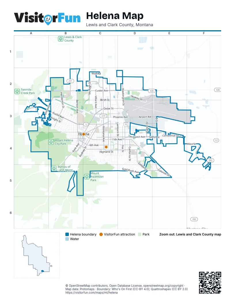
Street index of Helena
Each street on the sheet and the grid squares it crosses.
- First Special Service Force Memorial HighwayC2, C3, D3, D4, E4, E5
- Euclid AvenueA3, B3
- North Montana AvenueC2, C3, C4
- Prospect AvenueC4, D4
- East Custer AvenueC2, D2, E2
- North Last Chance Gulch StreetC3, B4, C4
- 11th AvenueC4, D4
- East Lyndale AvenueC3, D3, E3
- Cedar StreetC3, D3
- Helena AvenueC3, C4
- West Lyndale AvenueB3, C3
- North Dodge AvenueC2, C3
- North Benton AvenueB2, B3, B4
- Colonial DriveD4, E4, E5
- Washington StreetD2, D3, D4
- West Custer AvenueB2, C2
- Saddle DriveD4, D5, E5
- Henderson StreetB2, B3
- Green Meadow DriveB2
- North Park AvenueB3, B4
- North Fee StreetD3, D4
- Canyon Ferry RoadD2, E2
- Cruse AvenueB4, C4
- Montana Highway 282F5
- Neill AvenueB3, B4, C4
- Airport RoadD3, E3, F3
- North Sanders StreetC2, C3, C4
- East Broadway StreetB4, C4, D4
- Skyway DriveD2, E2, E3
- East 6th AvenueB4, C4, D4
- North Roberts StreetC2, C3, C4
- McHugh DriveC2, C3
- Alice StreetE4, F4
- North Ewing StreetC3, B4, C4
- Crossroads ParkwayE4
- Joslyn StreetB2, A3, B3
- North Rodney StreetC3, C4
- North Lamborn StreetD3, D4
- Phoenix AvenueC3, D3
- Villard AvenueC2, C3
- Chestnut StreetC3, D3
- Ptarmigan LaneC2
- Carter DriveD3, D4
- Country Club AvenueA2, A3
- South Alice StreetF4
- Runkle ParkwayF4
- Brady StreetB2
- Road Runner StreetC2
- South Park AvenueB4
- West Main StreetB4
- North California StreetD4
- West Lawrence StreetB4
- North Cruse AvenueB4, C4
- South Cruse StreetB4
- Valley DriveB2
- Lamborn StreetD3, D4
- Fuller AvenueB4
- Road Runner DriveC2
- East Lawrence StreetB4, C4
- Oro Fino GulchB5
- Oro Fino Gulch DriveB4, B5
- West Placer AvenueB4
- York RoadD2
- West 6th AvenueB4
- Jordan DriveC2
- 6th AvenueB4
- Knight StreetA3, B3
- 9th AvenueC4, D4
- Hauser BoulevardA3, B3
- Highland StreetC4, D4
- Flowerree StreetA3, B3
- Stuart StreetA3, B3
- 8th AvenueC4, D4
- 5th AvenueC4, D4
- Billings AvenueC3, D3
- Winne AvenueC4, D4
- Davis Gulch RoadB4, B5
- National AvenueC2, C3
- Wilder AvenueB3
- Gold Rush AvenueD5
- Cannon StreetA3, B3, D4
- Leslie AvenueA3, B3
- Cole AvenueC3
- Boulder AvenueC3, D3
- North Cooke StreetC2, C3, C4
- North Hannaford StreetD3, D4
- Hollins AvenueB3
- South California StreetD4, D5
- Bozeman AvenueD3, E3
- Peosta AvenueB3
- Choteau StreetA3, B3
- Harrison AvenueB3, B4
- Butte AvenueC4, D4
- Belt View DriveD4, C5, D5
- Waukesha AvenueB3
- Centennial DriveE4
- North Harris StreetC3, C4
- Le Grande Cannon BoulevardA3, B3
- University StreetA3, B3
- Missoula AvenueC4, D4
- Livingston AvenueC3, D3
- North Warren StreetC3, B4, C4
- Allison StreetB3
- Poplar StreetC3, D3
- Laurel StreetA3, B3
- Cleveland StreetB3
- Grant StreetB3
- Lockey AvenueC4, D4
- North Dakota StreetC3, C4
- Glendale StreetA3, B3
- North Oakes StreetC3, C4
- Lincoln StreetB3
- Garrison StreetB3
- North Jackson StreetC3, B4, C4
- Aspen StreetC3
- North Davis StreetC3, C4
- North StreetD4, E4
- Mountain View StreetB3
- Madison AvenueB3, B4
- Breckenridge StreetB4, C4
- 18th StreetD3, D4
- Townsend AvenueC3, D3
- Garfield StreetB3
- Walnut StreetC3, D3
- Bishop Carroll DriveB3, C3
- State StreetB4, C4
- South Rodney StreetB4, C4, B5
- Hudson StreetB3
- Columbia AvenueC2, C3
- Idaho AvenueC3, C4
- Jerome PlaceC4, D4
- 12th AvenueC4
- Elm StreetC3
- Birch StreetC2
- Orange AvenueC3
- Monroe AvenueB3, B4
- Dredge DriveC2
- Gold AvenueC2, C3
- Grizzly Gulch DriveB4, B5
- Logan StreetC3, C4
- Oregon StreetD3, D4
- Barney StreetB2, C2
- Skyway LoopE2, E3
- North Hoback StreetC4
- Dearborn AvenueB3, B4
- Cloverview DriveC2
- Cromwell Dixon LaneD2
- Cherry AvenueC3
- Horseshoe Bend RoadB2
- South Oakes StreetC4, C5
- Sonoma DriveD4, E4, D5, E5
- Stacia AvenueF4
- B StreetD3, E3
- South Harris StreetC4, C5
- 3rd StreetC4
- Spencer StreetB4, C4
- South Beattie StreetC4
- Sand Piper LoopC2
- South Montana AvenueC4
- Cabernet DriveE5
- Deerfield LaneE5
- Hayes AvenueB3, B4
- Hunthausen WayB3, C3
- Gilbert StreetB3
- Hickman DriveE2, D4
- Maple StreetC2
- Anderson BoulevardB3
- Virginia Dale StreetC4, C5, D5
- South Davis StreetB4, C4
- East 15th StreetC3, C4
- Blaine StreetD3, D4
- Wolf RoadC2
- Granite AvenueA3
- Elouise Cobell StreetF4
- Silverette StreetA3
- Power StreetB4
- Carriage LaneB4
- Elaine StreetE4
- Colter Loop DriveB2
- Reeders Village DriveB4
- Jade StreetC2
- Jeannette Rankin DriveF4
- Holter StreetB4
- Kelleher DriveD2
- Tricia StreetE4
- Diehl DriveC4
- War Eagle StreetF4
- South Roberts StreetC4
- Lewis StreetC3
- South Cooke StreetC4
- Chaucer StreetC4
- Meadow DriveB2, B3
- South Sanders StreetC4
- Hiawatha StreetA3
- Overlook BoulevardA3
- Front StreetC3, B4
- Humbolt LoopD5
- Southridge DriveD4, D5
- Linden StreetB3
- Hillsdale StreetC4
- Clarke StreetB4
- Graham StreetD4
- Insulator AvenueC2
- Briarwood LaneB2, B3
- Mendocino DriveE4, E5
- Northgate LoopB2
- East 16th StreetC3
- Greenwood DriveB3
- Cooney DriveB2
- Gallatin AvenueC3
- 7th AvenueB4, C4
- Sparta StreetB4, B5
- Broadwater AvenueA3
- South Fee StreetD4
- Ohio AvenueC4
- 2nd StreetC4
- Fairway DriveB2, B3
- North Beattie StreetC4
- Flagstone AvenueB2
- Twilight AvenueF4
- Partridge PlaceC2
- Expedition TrailC2
- Wedgewood LaneB2
- Tamarack StreetC4
- Silsbee AvenueB2
- Springfield DriveB2
- Illinois AvenueC4
- Winston StreetA3
- Getchell StreetB3
- Lola StreetE4
- Andesite AvenueB2
- Nicole StreetE3, E4
- Railroad AvenueC3, D3
- Tara CourtC2
- North Carson StreetC4
- Janet StreetE4
- Adams StreetB4
- Vandelay AvenueC4
- Broadwater CircleB3
- Memorial DriveC3
- South Howie StreetB4
- Red Alder LoopB2, B3
- Mitchell AvenueB2
- South Harrison AvenueB4
- West 14th StreetB3, C3
- Aspen View LoopF4
- Redletter StreetD4, D5
- Willowbrook DriveB2
- Comstock RoadD4
- Golden StreetC4, D4
- Brookfield DriveB2
- Gibbon StreetD3, D4
- East 14th StreetC3, C4
- 10th AvenueC4
- Alpine View DriveF4
- Roberts StreetC4
- Vigilante DriveB2
- Douglas StreetD4
- North Raleigh StreetC4
- Irene StreetE4
- Dorothy StreetE4
- Woodbridge DriveC4
- Dunbar AvenueB2
- East 13th StreetC4
- Geddis StreetD4
- Pine StreetB4
- Strawberry DriveC4
- Dayspring LoopD4
- Oakes StreetC4
- Peaks AvenueF4
- Big Timber LoopF4, F5
- Wakina Sky GulchB5
- Alexis AvenueF4
- Oakwood LaneB3
- South Warren StreetB4
- Harwood DriveB2, B3
- Raleigh StreetC4
- Russell LaneB2
- Cutler StreetB4
- Burnham PlaceD4
- Access RoadE2, E3
- Ming PlaceB4
- Rhode Island StreetC4
- Rock Ledge StreetD3, E3
- South Dakota StreetC4
- Summers Crossing AvenueF4
- Argyle StreetC3
- Elmwood LaneB2
- Mauldin StreetB3
- Washington DriveC4
- River Rock DriveC2
- Obsidian AvenueB2
- Lime Kiln RoadC5
- Blake StreetC4
- Shorthorn AvenueD2
- Snow Goose StreetC2
- Warehouse AvenueB3
- 1st StreetB4, C4
- Clancy StreetB4
- Amethyst AvenueC2
Things to do on the Helena map
Places on the map
- Barney Park
- Batch Memorial Park
- Benton Avenue Cemetery
- Bill Carson Memorial Park
- Bill Roberts Municipal Golf Course
- Bureau of Land Mgmt
- C R Anderson Middle School
- Capital High School
- Centennial / Bausch Park
- Custer Landing Marketplace
- Daisy Hill
- Dale Harris Park
- Delta Hotels Helena Colonial
- Exchange Field
- FedEx Ship Center
- Great Northern Town Center
- Helena College University of Montana Library
- Helena High School
- Helena Middle School
- Helena Regional Airport
- Helena Solid Waste Department
- Hustad Center
- Kessler Elementary School
- Lewis & Clark County Fairgrounds
- Lincoln Park
- Lowe's
- Meatloaf Hill
- Memorial Park
- Montana Historical Society Library and Archives
- Montana State Motor Pool
- Mount Ascension Park
- Mount Helena
- Mount Helena City Park
- Nature Park
- Nob Hill Park
- Northgate Plaza
- Ryan Park
- Saint Peter's Health
- Shodair Children's Hospital
- Siebel Fields
© OpenStreetMap contributors, Open Database License, openstreetmap.org/copyright · Map data: Protomaps · Boundary: Who's On First (CC-BY 4.0); Quattroshapes (CC BY 2.0)















