

Montana map
Lewis and Clark County map
About 75,129 people live here (Census Bureau, 2024 estimate). The sheet's index lists 300 streets; First Special Service Force Memorial Highway, Main Street and Lincoln Road West cross the most grid squares. Things to do inside the boundary: Gates of the Mountains, Montana State Capitol and Montana's Yellowstone Country.
Open the map (PDF, US Letter)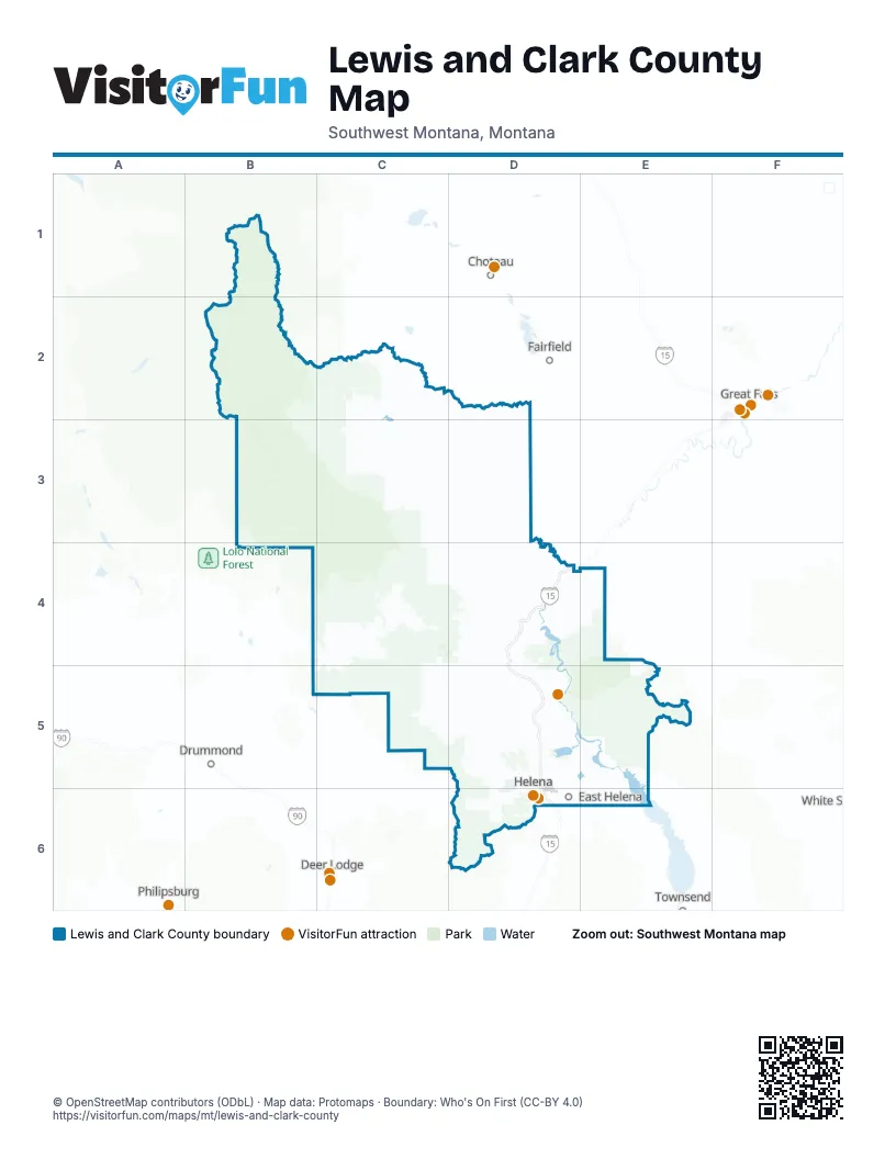
Street index of Lewis and Clark County
Each street on the sheet and the grid squares it crosses.
- First Special Service Force Memorial HighwayD3, D4, D5, D6
- North Montana AvenueD5, D6
- Euclid AvenueD6
- Prospect AvenueD6
- East Custer AvenueD5
- North Last Chance Gulch StreetD6
- Main StreetC2, D4, C5, D5
- 11th AvenueD6
- East Lyndale AvenueD6
- Montana Route 518D6
- Cedar StreetD6
- Helena AvenueD6
- West Lyndale AvenueD6
- North Dodge AvenueD5, D6
- Manix StreetC2
- Lincoln Road WestC4, C5, D5
- Canyon Ferry RoadD5, E5
- Birdseye RoadD5
- Green Meadow DriveD5
- Lake Helena DriveD5, D6
- Montana Highway 279C4
- Lincoln Road EastD5
- Hauser Dam RoadD5
- North Benton AvenueD5, D6
- Colonial DriveD6
- Washington StreetD5, D6
- Williams StreetD5, D6
- West Custer AvenueD5
- Saddle DriveD6
- Montana Highway 282D6
- Henderson StreetD5, D6
- East Main StreetD6
- North Park AvenueD6
- North Fee StreetD6
- Cruse AvenueD6
- Neill AvenueD6
- Ten Mile Creek BridgeD6
- York RoadD5, E5
- Copper Creek RoadB3, B4, C4
- Craig Frontage RoadD3, D4
- Little Prickley Pear RoadC5
- Rimini RoadC6, D6
- Recreation Road SouthD4
- Marysville RoadC5, D5
- Valley DriveD5, D6
- Applegate DriveD5
- Wylie DriveD5, D6
- Oro Fino GulchD6
- Spokane Creek RoadE5, E6
- Airport RoadD6
- Deal LaneD5, E5
- North Sanders StreetD5, D6
- Gates of the Mountains RoadD5
- East Broadway StreetD6
- John G Mine RoadD5
- Sierra Road EastD5
- Skyway DriveD5, D6
- Floweree DriveD5
- Franklin Mine RoadD5
- McHugh LaneD5
- Country Club AvenueD5, D6
- East 6th AvenueD6
- Recreation RoadD4
- North Roberts StreetD5, D6
- McHugh DriveD5, D6
- Forestvale RoadD5
- Mill RoadB4, D5
- Norris RoadD5
- Alice StreetD6
- North Ewing StreetD6
- Crossroads ParkwayD6
- Joslyn StreetD5, D6
- North Rodney StreetD6
- North Lamborn StreetD6
- Phoenix AvenueD6
- Villard AvenueD5, D6
- Chestnut StreetD6
- Sierra Road WestD5
- West Main StreetD6
- Ptarmigan LaneD5
- Carter DriveD6
- Bridge StreetD3
- South Alice StreetD6
- Runkle ParkwayD6
- Brady StreetD5
- 6th AvenueB4, D6
- Sierra RoadD5
- Road Runner StreetD5
- South Park AvenueD6
- North California StreetD6
- West Lawrence StreetD6
- North Cruse AvenueD6
- South Cruse StreetD6
- Honor DriveD5
- Lamborn StreetD6
- Liberty LaneD5
- Fuller AvenueD6
- Road Runner DriveD5
- Jordan DriveD5
- East Lawrence StreetD6
- Oro Fino Gulch DriveD6
- West Placer AvenueD6
- Lane AvenueD6
- 4th StreetC5, D6
- West 6th AvenueD6
- Dearborn River High BridgeC2
- South Lane AvenueD6
- Wegner Creek BridgeD3
- Benchmark RoadB1, B2, C2
- Stemple Pass RoadB4, C4
- Sun Canyon RoadB1, C1, C2
- Beaver Creek RoadE4, D5, E5
- Little Wolf Creek RoadC3, D3, D4
- Smith Creek RoadB2, C2
- Beaver Willow RoadB1, B2
- Chevallier DriveD4, D5
- Beartooth RoadD4
- Marsh Creek RoadC4, C5
- Sucker Creek RoadB4, C4
- Flat Creek RoadC2
- Black Rock RoadC2, D2
- Alice Creek RoadC3, C4
- Elk Creek RoadB2, C2
- Nelson RoadE5
- Austin RoadC5, D5
- Dalton Mountain RoadB4, B5
- Gravelly Range RoadC4, C5
- North Beaver Creek RoadB4
- Long Butte RoadD2
- Ophir CaveC5
- Warden RoadC1, C2
- Blossburg RoadC5
- Barr Creek RoadB1, C1
- Augusta-Clemons RoadC2
- Sevenmile RoadD3
- Craig River RoadD3, D4
- Dearborn Canyon RoadC2, C3
- MRL Service RoadC5, D5
- Empire Creek RoadC5
- Favorite Gulch RoadE5
- Grizzly Gulch DriveD6
- Priest Pass RoadC5, C6, D6
- Jimtown RoadE5
- Black Bear RoadE5
- North Lyons Creek RoadD4
- Elkhorn Creek RoadD4, E4
- Lyons Creek RoadD4
- American Bar RoadD5
- Hope Creek RoadC5
- Deadman Coulee RoadD3
- Frontage RoadD5
- L&C RoadC3
- Bray Gulch RoadD4
- Minnehaha Creek RoadC6
- Birdtail RoadD3
- West Shore DriveE5, E6
- Rocky RoadD3, D5
- Colorado Gulch DriveD6
- Stonewall Creek RoadB4
- Long Gulch RoadC5
- Spokane Ranch RoadE6
- Skelly Gulch RoadC5, D5
- East Shore DriveE5
- Blue Cloud RoadD5, D6
- Chisolm-Barret RoadC2
- Simms Creek RoadD2
- Lost Horse Creek RoadC5
- Sperry RoadD4, D5
- South Fork TrailC3, D3
- Head LaneD5
- Hay Coulee RoadC2
- Ward RoadE5
- Raven RoadC5, D5
- Hart LaneE5
- Black Sandy LoopD5
- Glass DriveD5
- Eagle Bay DriveE5
- Duffy LaneC5, D5
- Danas Point DriveD5, E5
- Snowshoe Deadwood RoadC5
- Collins DriveD5
- Fool Hen RoadC4
- Three Mile RoadC5, D5
- Basin Creek RoadC6
- Ox Bow DriveD4
- Woodland Hills RoadD5
- Ottawa Gulch RoadC5
- Pishkun LaneC1
- West Hogum Creek RoadC4
- Prairie RoadD5
- Eberl LaneC1, C2
- Rock Creek Loop RoadD3
- Bob Thomas RoadC1, C2
- Goss Creek RoadB2, C2
- Magpie Gulch RoadE5
- Herrin Lake RoadB4
- Timber Trail DriveD5
- Deer Creek RoadC5
- Silver Creek RoadD5
- Charbonneau DriveD3
- Hogum Creek RoadC4
- Cellar Gulch RoadC5
- French Creek RoadC4, D4
- Gehring Ranch RoadB4
- Woods Siding RoadD4
- Horse Fly Creek RoadC4
- South Fork RoadC5
- FS 1829B4
- Beaver Slide LoopD3, E3
- Landers Fork RoadC4
- July RoadD3, E3
- Little Falcon DriveC5, D5
- Diehl Ranch DriveE5, E6
- Keir LaneE5
- North Fork RoadD3, E3
- Helberg DriveD5
- East Loren RoadD5
- Big Sawmill RoadC4
- Holter Dam RoadD4
- Huotari LaneD5, E5
- Woodridge TrailE5
- Ferry DriveD5
- Banner Creek RoadC6
- Gould Creek RoadC4
- Diamond Bar X RoadC3
- Lake RoadC4, C5
- Snowdrift RoadD5
- Diamond Springs DriveD5
- Johannes Hill RoadC2, C3
- Cedar Valley RoadD5, E5
- Sauerkraut Creek RoadB4
- 8th AvenueB4, D6
- Mike Horse Creek RoadC4
- Swallow Canyon RoadC2
- Hauser BoulevardD6
- North Slope RoadD5
- Rainbow DriveD5
- Snowshoe - DeadwoodC5
- Iron Ridge LoopC5
- Le Grande Cannon BoulevardD6
- Indian Meadows RoadB3
- 9th AvenueB4, D6
- Knight StreetD6
- Ponderosa DriveC1, B4, C4
- Fleming StreetC2, B4
- Tea RoadD5
- Greenpole Creek RoadC3, C4
- Deer Park DriveD5
- Fantasy RoadD5
- Craigle LaneE5
- North Lincoln Gulch RoadB4
- Wooten RoadD5
- Willow Creek RoadC1, D6
- Lincoln Gulch RoadB4
- Lone Pine RoadD5
- Lone Point DriveB4
- Hilger RoadD4, D5
- Landers ForkC3, C4
- Stonehouse RoadD5
- Woods Creek RoadC3, C4
- Cox Creek LaneE3
- Guffy's Cove RoadE5
- Augusta Ranger Station RoadB2
- Highland StreetC5, D6
- Belmont DriveC5
- Flowerree StreetD6
- Wilder AvenueD6
- Johns LaneC5
- Gilman RoadC1
- Howard RoadD5
- Barrett RoadD5
- Stuart StreetD6
- Turk RoadC5, D5
- Baxendale DriveD6
- Eagle Canyon DriveD3
- Harmony RoadD5
- Aspenway DriveD6
- Pine Hills DriveE5
- Allen RoadC2
- Dry Gulch DriveD6
- Elkhorn RoadE5
- Anderson RoadC5
- Eames LaneE5
- Davis Gulch RoadD6
- Bitteroot LaneC1
- Douglas CircleD5
- Viscaya RoadE5
- Guthrie RoadD5
- Sleeping Giant View DriveD5
- Johnson RoadE6
- 5th AvenueD6
- Spring Creek TrailC5
- Wakina Sky GulchD6
- Cannon StreetD6
- Tizer RoadD5
- Denton Gulch RoadC3
- Cedar DriveC1
- Deer Meadow DriveD6
- Masonic Home RoadD5
- Billings AvenueD6
Things to do on the Lewis and Clark County map
Places on the map
- Anderson Lake
- Augusta
- Bean Lake
- Beartooth Wildlife Management Area
- Bureau of Land Mgmt
- Canyon Creek Wildlife Management Area
- Chessman Reservoir
- Department of Defense
- East Helena
- Fort William Henry Harrison
- Fox Ridge Golf Course
- Gates of the Mountains Wilderness
- Gibson Reservoir
- Gravelly Range Lake
- Great Divide Ski Area
- Green Meadow Country Club
- Hauser Lake
- Helena
- Helena Valley Northeast
- Helena Valley Northwest
- Helena Valley Southeast
- Helena Valley West Central
- Hellgate Campground
- Holter Lake
- Keep Cool Lakes
- Lake Helena
- Lake Helena Wildlife Management Area
- Lewis & Clark County
- Lincoln
- Mount Ascension Park
- Mount Helena City Park
- Nilan Reservoir
- Pretty Prairie
- Scapegoat Wilderness
- Sleeping Giant Wilderness Study Area
- Sun River Wildlife Management Area
- Tenmile Creek Park
- Tobacco Valley
- Upper Holter Lake
- Wood Creek
Next to Lewis and Clark County
- Deer Lodge
- Drummond
- Fairfield
- Great Falls map
© OpenStreetMap contributors, Open Database License, openstreetmap.org/copyright · Map data: Protomaps · Boundary: Who's On First (CC-BY 4.0); Quattroshapes (CC BY 2.0)