

Montana map
Missoula map
About 78,204 people live here (Census Bureau, 2024 estimate). The sheet's index lists 300 streets; Lower Miller Creek Road, Jeannette Rankin Memorial Highway and North Reserve Street cross the most grid squares. Things to do inside the boundary: Glacier Country Regional Tourism Commission, Historical Museum at Fort Missoula and Missoula People's Market.
Open the map (PDF, US Letter)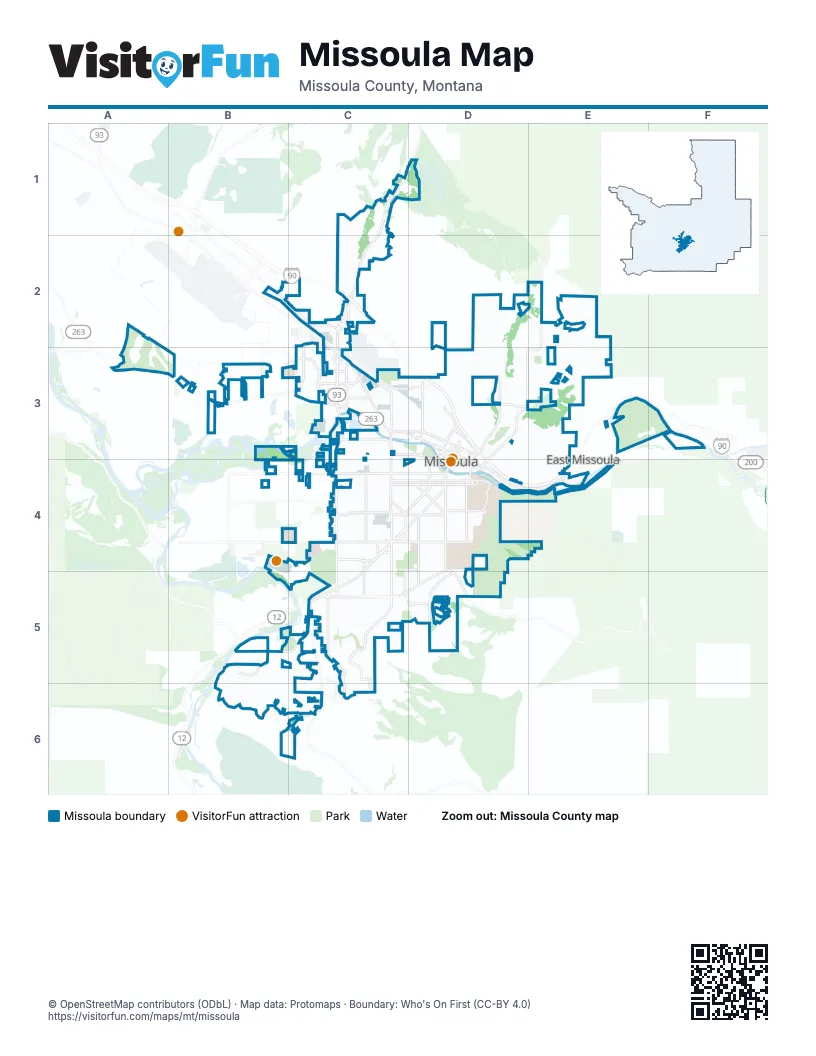
Street index of Missoula
Each street on the sheet and the grid squares it crosses.
- Jeannette Rankin Memorial HighwayC2, D3, D4
- North Reserve StreetC2, C3, C4
- Brooks StreetC4, D4, C5
- West Broadway StreetC2, C3, D3
- Mullan RoadA3, B3, C3
- South Reserve StreetC4, C5
- South Avenue WestB4, C4, D4
- Stephens AvenueC4, D4, C5
- East Broadway StreetD3, D4, E4
- South Higgins AvenueD4
- Arthur AvenueD4
- North Orange StreetD3
- South 5th Street EastD4
- South 6th Street EastD4
- Van Buren StreetD3, D4
- South Orange StreetD3, D4
- Madison StreetD3, D4
- North Higgins AvenueD3, D4
- Knowles StreetC4
- Bitteroot RoadC5
- South 3rd Street WestB4, C4, D4
- South Russell StreetC4, C5
- Mount AvenueC4, D4
- 39th StreetC5, D5
- North Russell StreetC3, C4
- Expressway RoadB2, C2
- Southwest Higgins AvenueD4, C5, D5
- South 14th Street WestC4
- Hill StreetD4
- Old Montana 200E4
- Grant Creek RoadC1, C2, C3
- Rattlesnake DriveE2, D3, E3
- Lower Miller Creek RoadB5, C5, B6, C6
- Hillview WayC5, C6
- Gharrett StreetC5, C6
- Duncan DriveD2, D3
- South Garfield StreetC4, C5
- South 5th Street WestC4, D4
- South 6th Street WestC4, D4
- Whitaker DriveD5
- West Sussex AvenueC4, D4
- Wyoming StreetC3, D3
- River RoadC3
- Maurice AvenueD4
- England BoulevardC3
- South Johnson StreetC4
- Bancroft StreetD4, D5
- Palmer StreetC3, D3
- Scott StreetD3
- Mary AvenueC4, D4
- West Greenough DriveD3
- Fairview AvenueC4, D4
- Mary Jane BoulevardC2, C3
- Southgate Mall Access RoadC4
- Washburn StreetC4, C5
- Miller Creek RoadC5, C6
- Great Northern AvenueC3
- Toole AvenueC3, D3
- Connery WayC3
- Rodgers StreetC3, D3
- Campus DriveD4
- East Beckwith AvenueD4
- Pattee Creek DriveC4, D4
- Paxson StreetC4, C5
- Pattee Canyon RoadD4, D5
- West Spruce StreetD3
- Railroad Street WestC3
- American WayC3
- North Van Buren StreetD3
- High Park WayC5, D5
- George Elmer DriveB3
- East Front StreetD4
- North 5th Street WestD3
- Lolo StreetD3
- West Beckwith Street EastD4
- South Avenue EastD4
- Union Pacific StreetC3
- Worden AvenueD3
- West Front StreetD3, D4
- Ryman StreetD3, D4
- North 2nd Street EastD3
- Howard Raser AvenueC2
- Flynn LaneC3
- North 2nd Street WestD3
- O'Leary StreetC3
- Latimer StreetC3
- East Spruce StreetD3
- East Main StreetD3, D4
- North Pattee StreetD3, D4
- Cemetery RoadC3
- Clark Fork LaneC3
- West Main StreetD3
- Cregg LaneD3, D4
- Raser DriveC3
- West Beckwith Street WestD4
- Spurgin RoadC4
- Sussex BendC4, D4
- South Van Buren StreetD4
- Walnut Street SouthD4
- Old Van Buren StreetD4
- West Beckwith StreetD4
- North LoopE2, E3
- North Avenue WestB4, C4, D4
- West Kent AvenueC4, D4
- Linda Vista BoulevardB5, B6, C6
- Lower Lincoln Hills DriveE2, D3, E3
- South 4th Street WestC4, D4
- Christian DriveB5, B6, C6
- Strand AvenueC4, D4
- South 7th Street WestB4, C4
- Burlington AvenueC4, D4
- Schilling StreetC4, C5
- Dixon AvenueC5, D5
- South Catlin StreetC3, C4
- Kensington AvenueC4, D4
- Eaton StreetC4, C5
- Deer Creek RoadE3, F3
- Central AvenueC4, D4
- Dearborn AvenueC4, D4
- Kemp StreetC4
- Prospect DriveC1, C2
- 34th StreetC5, D5
- McDonald AvenueC5
- 23rd AvenueC5
- Gerald AvenueD4
- South 2nd Street WestC4, D4
- Park StreetD4, D5
- Ronald AvenueD4
- Briggs StreetC5
- Hollis StreetD4, D5
- Hilda AvenueD4
- Helen AvenueD4
- Longview DriveC5, C6
- Benton AvenueC4, D4
- West Artemos DriveD5
- Livingston StreetC4, D4
- Cooper StreetC3, D3
- Sherwood StreetC3, D3
- Spanish Peaks DriveD5
- Mansion Heights DriveD5
- South 10th Street WestC4
- Roundup DriveB3
- South Grant StreetC4
- Scott Allen DriveB6, C6
- Agnes AvenueC4, D4
- Queen StreetD4, D5
- Ranch Club RoadA3
- Clark StreetC4, C5
- Thames StreetD4
- Anglers Bend WayE3
- Cattle DriveB3
- South 9th Street WestC4
- Shakespeare StreetD3
- Phillips StreetC3, D3
- Westview DriveD5
- Defoe StreetC3, D3
- Fort Missoula RoadC4
- Ernest AvenueC4
- Saint Thomas DriveC5
- Howell StreetC3, D3
- Stoddard StreetC3, D3
- Monroe StreetD3, D4
- Montana StreetC3, D3
- Helena DriveB5
- Jackson StreetD3, D4
- South 1st Street WestC4, D4
- North Dickens StreetD3
- Parkview WayD5
- Woodford AvenueD4
- Old US Highway 93C5
- Lester StreetD4
- East Pine StreetD3, D4
- South 12th Street WestC4
- Turner StreetC3, D3
- Cooley StreetC3, D3
- Rollins StreetC4, D4
- Edith StreetD4
- Cleveland StreetC4, D4
- Skyview DriveC5
- Mainview DriveC5
- Post Siding RoadC4, C5
- Mountain View DriveD3, E3
- Raymond AvenueD3
- South Washburn StreetC4
- Eldora LaneB5, C5
- West Pine StreetD3
- Central Avenue WestD4
- South 13th Street WestC4
- East Crestline DriveD5
- Garland DriveC5
- Ben Hogan DriveD5
- Evans AvenueD4
- South 11th Street WestC4
- Tina AvenueC3
- Arrowhead DriveC5
- Beverly AvenueD4
- Canyon River RoadE3, F3
- Margaret StreetC4
- Simons DriveC5, D5
- Gleneagle WayC1, C2
- Woodworth AvenueD4
- Rimel RoadC5, D5
- South Hills DriveC5
- O'Shaughnesy StreetC3
- Clark Fork DriveC3
- Gilbert AvenueD3
- Idaho StreetC3
- Brookside WayD3
- Coachman WayE3, F3
- Dickinson StreetD3, E3
- Longstaff StreetC4, D4
- Rustler DriveA2, A3
- Harrison Scott DriveB5, B6
- Charlo StreetC3, D3
- Ronan StreetC4
- Hickory StreetD3, D4
- Jack DriveB5
- Holmes StreetD3
- Brandon WayC6
- H RoadC4, C5
- Harrison StreetD3, D4
- Hastings AvenueD4
- Jeff DriveB6, C6
- Burns StreetC3
- 55th StreetC5
- Stratford LaneC2, C3
- Fleet StreetC3
- Cottonwood StreetD3, D4
- TimberlaneD2, D3
- Potter Park LoopC2
- Burton StreetD3
- Grant StreetC4, C5
- Highwood DriveC5
- Valley View DriveC5
- Blaine StreetD4
- Grandview WayC5
- Bunkhouse PlaceA3
- Bow StreetD4
- Bulwer StreetC3
- Eddy AvenueD4
- North Easy StreetE4
- West Alder StreetD3
- Fairway DriveD5
- Concord DriveC2, C3
- Missoula AvenueD3
- 36th StreetC5
- Horn RoadB3
- Fox Farm RoadD2, D3
- East Central AvenueD4
- East Kent AvenueD4
- East Sussex AvenueD4
- Woodland AvenueD3
- Charlott AvenueC5
- Bandmann TrailF3
- Bigfork RoadB5
- North Avenue EastD4
- Connell AvenueD4
- South California StreetC3, C4
- Byron StreetC3
- Lexington AvenueC3
- Cowper StreetC3
- East Crosby StreetD4
- Sheffield DriveC2, C3
- West Addison StreetC4, D4
- North Davis StreetC3, C4
- Mansfield AvenueD4
- Sunflower DriveD3, E3
- Waverly StreetD3
- South Inez StreetC4
- Chestnut StreetD4
- Starwood DriveC1, D1
- 42nd StreetC5
- Pinnacle PlaceC1
- Teddy TurnD2, D3
- East Florence StreetD4
- Heavens GateC5
- Jaiden LaneB5, B6
- Oxford StreetC4
- Parkwood DriveC1, D1
- Black Fox TrailD2
- North California StreetC3
- Lincoln RoadD2, D3
- Dean Stone DriveD5
- Poplar StreetD3, D4
- International DriveC2
- Woody StreetD3
- McIntosh LoopC4
- Hiberta StreetC4
- Highland Park DriveD5
- Bordeaux BoulevardB2, C2
- MonrocC3
- Wylie AvenueD3
- West Crestline DriveD5
- South Easy StreetE4
- G RoadB4, C4
- West Bickford StreetC4, D4
- Marshall StreetC4, D4
- Weeping Willow DriveC5
- Wapikiya DriveC5
- Hawthorne StreetD3
Things to do on the Missoula map
Places on the map
- AC Hotel Downtown Missoula
- Adams Event Center
- Bancroft Pond Nature Area
- Bellevue Park
- Ben Hughes Park
- Bess Reed Park
- Big Sky High School
- Bugbee Nature Preserve
- Canyon River
- Canyon River Beach
- Canyon River Golf Club
- Caras Park
- Chief Charlo Elementary School
- Clark Fork Natural Park
- Cold Springs School
- Community Medical Center
- Fort Missoula
- Greenough Park
- Jacob's Island
- Larchmont Golf Course
- Lewis and Clark Square
- Linda Vista Golf Course
- McCormick Park
- Missoula Cemetery
- Missoula County Detention
- Missoula County Fairgrounds
- Moon-Randolph Homestead
- Moose Can Gully
- Palmer Professional Park
- Peery Park
- Rollin Field
- Russell Square
- Sleven's Island
- South Crossing
- Southgate Mall
- Spartan Park
- Ten Spoon Vineyard and Winery
- The Ranch Club Golf Course
- University Golf Course
- Wilma Theatre
Next to Missoula
- East Missoula
© OpenStreetMap contributors, Open Database License, openstreetmap.org/copyright · Map data: Protomaps · Boundary: Who's On First (CC-BY 4.0); Quattroshapes (CC BY 2.0)