

Montana map
Missoula County map
About 122,546 people live here (Census Bureau, 2024 estimate). The sheet's index lists 300 streets; Butler Creek Road, Lolo Creek Road and Mullan Road cross the most grid squares. Things to do inside the boundary: Glacier Country Regional Tourism Commission, Historical Museum at Fort Missoula and Missoula.
Open the map (PDF, US Letter)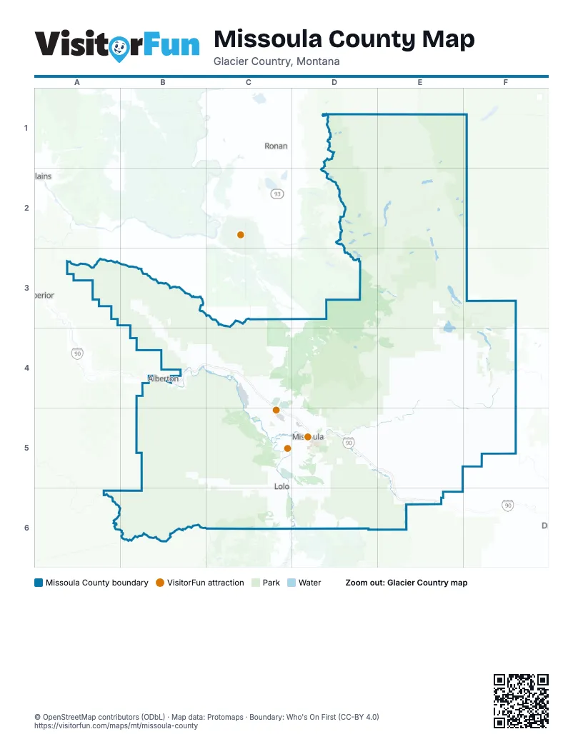
Maps inside Missoula County
1 map inside, from the street map of Missoula County down.
Street index of Missoula County
Each street on the sheet and the grid squares it crosses.
- Jeannette Rankin Memorial HighwayD5
- Airway BoulevardC5
- Lolo Creek RoadB5, C5, B6, C6
- Mullan RoadB4, C4, C5, D5
- Nez Perce National Historic TrailC5, B6, C6
- West Broadway StreetC4, C5, D5
- Montana Highway 200D5
- South Avenue WestC5, D5
- North Reserve StreetD5
- Brooks StreetC5, D5
- Bitteroot RoadC5
- South Reserve StreetD5
- Stephens AvenueD5
- East Broadway StreetD5
- Louis Charles Charlo Memorial HighwayC4
- South Higgins AvenueD5
- Beckwith StreetC4
- Arthur AvenueD5
- North Orange StreetD5
- South 5th Street EastD5
- South 6th Street EastD5
- Van Buren StreetD5
- South Orange StreetD5
- Madison StreetD5
- North Higgins AvenueD5
- Knowles StreetD5
- Demer StreetC4
- US Highway 93 SouthC5
- McNamara BridgeE5
- Wisherd BridgeD5
- Wildlife overcrossingC4
- Clearwater BridgeF4
- Petty Creek RoadB4, B5
- Frenchtown Frontage RoadB4, C4
- Expressway RoadC5, D5
- Old Montana 200D5
- South 3rd Street WestC5, D5
- Mount AvenueC5, D5
- South Russell StreetD5
- Old US Highway 10C4
- 39th StreetD5
- Pulp Mill RoadC4
- North Russell StreetD5
- QuarrieD5, E5
- Southwest Higgins AvenueD5
- South 14th Street WestD5
- 1st StreetD5, E5
- Adams StreetB4
- Hill StreetD5
- I90-Hwy 10W Frontage RoadB4
- Six Mile RoadC3, B4, C4
- Miller Creek RoadC5, D5, D6
- Butler Creek RoadB3, B4, C4, D4, C5
- Kraft Creek RoadD2, E2
- Big Flat RoadC5
- Nine Mile RoadA3, B3, B4
- Deer Creek RoadD5
- East Mullan RoadD5, E5, E6
- Boy Scout RoadE3, F3
- Grant Creek RoadD4, D5
- Owl Creek Loop RoadE2
- Lindbergh Lake RoadE2
- Lower Miller Creek RoadC5, D5
- Frontage RoadB4
- Old US Highway 93C5, D5, C6
- Pattee Canyon RoadD5
- Rattlesnake DriveD5
- Graves Creek RoadB5
- Main StreetC4
- Houle Creek RoadC4
- Wallace Creek RoadE5
- Rock Creek RoadE6
- Sawmill Gulch RoadB4, D4, D5
- Blue Mountain RoadC5
- Spurgin RoadC5, D5
- Turah RoadD5
- Gharrett StreetD5
- Holland Lake RoadE2
- Hillview WayD5
- Rustic RoadD5
- Bonita Station RoadE6
- England BoulevardC5, D5
- South 5th Street WestD5
- Duncan DriveD5
- West Carlton Creek RoadC6
- South Garfield StreetD5
- West Sussex AvenueC5, D5
- South 6th Street WestC5, D5
- South Holland Lake RoadE2
- Beavertail RoadE6
- Whitaker DriveD5
- Wyoming StreetD5
- Flynn LaneC5, D5
- Alberton Frontage RoadB4
- River RoadD5
- Maurice AvenueD5
- South Johnson StreetD5
- Bancroft StreetD5
- Clements RoadC5
- Mary Jane BoulevardC5
- Palmer StreetD5
- Scott StreetD5
- Waldo RoadC4
- Rodgers StreetD5
- Mary AvenueD5
- West Greenough DriveD5
- Fairview AvenueD5
- Southgate Mall Access RoadD5
- Washburn StreetD5
- Railroad Street WestD5
- Great Northern AvenueD5
- Rowan RoadC6
- Kona Ranch RoadC5
- Toole AvenueD5
- Connery WayD5
- Campus DriveD5
- East Beckwith AvenueD5
- Pattee Creek DriveD5
- Paxson StreetD5
- West Spruce StreetD5
- George Elmer DriveC5
- American WayD5
- North Van Buren StreetD5
- High Park WayD5
- East Front StreetD5
- North 5th Street WestD5
- Clark Fork LaneD5
- Lolo StreetD5
- West Beckwith Street EastD5
- Raser DriveD5
- South Avenue EastD5
- Union Pacific StreetD5
- East Kona Rapids RoadC5
- Worden AvenueD5
- West Front StreetD5
- Ryman StreetD5
- North 2nd Street EastD5
- Howard Raser AvenueD5
- North 2nd Street WestD5
- O'Leary StreetC5, D5
- Latimer StreetD5
- East Spruce StreetD5
- East Main StreetD5
- North Pattee StreetD5
- Cemetery RoadD5
- Timber Edge DriveD5
- West Main StreetD5
- Cregg LaneD5
- West Beckwith Street WestD5
- Upper Miller Creek RoadC5
- Sussex BendD5
- South Van Buren StreetD5
- Walnut Street SouthD5
- Old Van Buren StreetD5
- West Beckwith StreetD5
- Rice Ridge RoadE2, E3
- West Side Ninemile Road - USFS Rd 5520A3, B3
- Southside RoadB4, C4, C5
- Beaver Creek RoadE2, E3
- Belmont-BolesE4
- Spook LakeE4
- Elk Creek RoadD1, E1, E2, F5
- Placid Creek RoadE3, F3, E4, F4
- Edith Peak RoadB3, C3, B4, C4
- Ninemile RoadB3, B4
- Albert Lothrop RoadB4, C4
- Allen Creek RoadD5
- Blue Mountain LookoutC5
- Mill Creek RoadC3, C4, C6
- Point Six RoadD4
- South Fork RoadD3, E3, D4, E4
- Blanchard Creek RoadE4, F4
- Morrell - Clearwater RoadE2, E3, F3
- West Fork Petty Creek RoadB4, B5
- Elk Meadows RoadC5, B6, C6
- Ninemile Prairie RoadE4, F4
- Verdy Moccasin RidgeD5, E5, D6, E6
- Foothills Road - USFS Rd 5498A3, B3
- Garnet Range RoadF5
- Gold Creek RoadE4, E5
- Clearwater Lake Loop RoadE2
- Sluice Creek RoadD6
- Ashby Creek RoadE5
- Bitterroot Divide RoadD6, E6
- Wagon Mountain RoadB5
- West Fork Schwartz Creek RoadD6, E6
- Larch Camp RoadD5
- Sunset Hill RoadF4, F5
- Plant Creek #2132D5, D6
- Granite Creek RoadA6, B6
- Richmond Ridge RoadE2
- Cow CreekE4
- Cottonwood Lakes RoadF3, F4
- Colt Creek RoadE2, E3
- Schwartz Creek RoadD6, E6
- Ninemile-Pardee Road =USFS Rd 97A3
- Jocko RoadD3, E3
- MRL Service RoadD5, E6
- East Fork RattlesnakeE4
- Cramer Creek RoadE5, E6
- Sawyer Creek RoadE3
- Archibald Creek LoopE3
- Swanson LaneE5
- Lake ElsinaE3
- Morrison Peak RoadE4, E5
- Finley Creek RoadE3, E4
- Ulher Creek RoadE2
- West Fork Clearwater RoadE2, E3
- East Ashby Creek RoadE5
- Old Richmond RoadE2
- Johnsrud Park RoadE4, E5
- Fish Creek RoadF5, B6
- South Placid Lake RoadE3, E4
- Jim Lakes RoadD1
- West Side Bypass RoadE3
- Ed's RidgeB5
- Howard Creek RoadB5
- Barber Creek RoadE1, E2
- Three CougarsD4, E4
- Fawn Creek RoadE3
- Gold RidgeE4
- Deep Creek RoadC5
- Snow Bowl RoadD4
- Dirty Ike Creek RoadE5
- Fawn Creek - Placid CreekE3
- Woodworth RoadF4
- Corral Creek RoadB4
- Middle Fork Schwartz #4244D6
- Holloman - SchwartzD6
- Bear Creek RoadC5, E5
- Crystal Creek RoadD5
- Cold Creek RoadD1, E1
- West Side Ninemile - First Creek - USFS 5475A3
- West Fork Gold CreekE4
- Ellis Creek RoadB4
- Black Cat Gulch RoadC4
- Lost Prairie Creek RoadF4
- East Twin Creek RoadE4, E5
- Henry MountainE3
- Jocko LookoutD3, D4
- Ninemile-Siegle Road - USFS Rd -412A3
- Mc Clain Creek RoadC6
- Hole-in-the-Wall RoadE5, F5
- West Ninemile RoadB4
- Albert Creek RoadC4
- Lower Marshall Lake RoadE3
- FS 4365F3
- Sperry Grade RoadF4, F5
- Valley of the Moon RoadE6
- North Placid Lake RoadE3
- West Fork Bear Creek RoadE5
- O'Brien Creek RoadC5
- Falls Creek Alder Creek RoadE1
- North Avenue WestC5, D5
- Camp Creek RoadE2, E3
- Buck Creek RoadE1, E3
- West Fork Gold Creek (North)D4, E4
- Beaver-Finley CreekE4
- Findell Creek RoadE3
- La Valle Creek RoadC4, D4
- Rumble Creek RoadE1
- Milwaukee Road Railroad GradeD5
- South 7th Street WestC5, D5
- Mormon Creek RoadC6
- Spooner Creek RoadD6
- Blue MountainC5
- Rosco RoadB4
- Double Arrow RoadF3
- Conifer DriveB4
- White Horse LakeD3
- Skimmerhorn RoadF5
- Cold Brook RoadE4, F4
- Cap Wallace RoadF5
- Falls Creek RoadE1
- West Rennic Creek RoadB4
- North LoopD5
- Scenic DriveE1, E2
- Smith Creek RoadE1
- Waldbillig RoadE1, E2
- Boles Meadow RoadD4, E4
- Lola LaneE5
- Trails End RoadC5, D5
- Potomac RoadE5
- Second Creek RoadE3
- Skyline Drive (South) #2127-2D5, D6
- Skyline Drive (North) - 2127-1D5
- Lower Woodchuck RoadD6
- Upper Woodchuck Creek RoadD6
- Deschamps LaneC4, C5
- Sleeman Creek RoadC5
- Upper Twin Creek RoadD4, E4
- Lavalle SpurD4
- Peck Lake RoadD1
- McCormick Creek RoadB3
- Old Petty Creek RoadB5
- Elkhorn RoadF3
- Moccasin LaneC4
- Koontz LaneE5
- Marshall Canyon RoadD5
- Remount RoadB4
Things to do on the Missoula County map
Places on the map
- Beavertail Hill State Park
- Big Sky Park
- Black Lake
- Blue Mountain Disk Golf
- Bonner-West Riverside
- Boulder Lake
- Canyon River
- Canyon River Golf Club
- Clark Fork
- Clearwater Lake
- Clinton
- Colt Lake
- Cottonwood Lakes
- Council Grove State Park
- Crystal Lake
- Deep Creek Shooting Range
- Doctor Lake
- Double Arrow Golf Course
- East Missoula
- Elbow Lake
- Elk Lake
- Elk Meadow
- Evaro
- Farmers Lakes
- Finley Lakes
- Fish Lake
- Fissure Glacier
- Fort Missoula Regional Park
- Frenchtown
- Frenchtown Pond State Park
- George Lake
- Glacier Lake
- Glacier Sloughs
- Jocko Tribal Primitive Area
- Marshall Creek Wildlife Management Area
- Milltown State Park
- Mission Mountains Wilderness
- MPG Ranch
- Rattlesnake National Recreation Area
- Rattlesnake Wilderness
Next to Missoula County
- Alberton
- Plains
- Ronan
- Superior
© OpenStreetMap contributors, Open Database License, openstreetmap.org/copyright · Map data: Protomaps · Boundary: Who's On First (CC-BY 4.0); Quattroshapes (CC BY 2.0)