

North Carolina map
Concord map
About 112,395 people live here (Census Bureau, 2024 estimate). The sheet's index lists 300 streets; Concord Parkway South, Davidson Highway and Poplar Tent Road cross the most grid squares. Things to do inside the boundary: Charlotte Motor Speedway and Concord Mills.
Open the map (PDF, US Letter)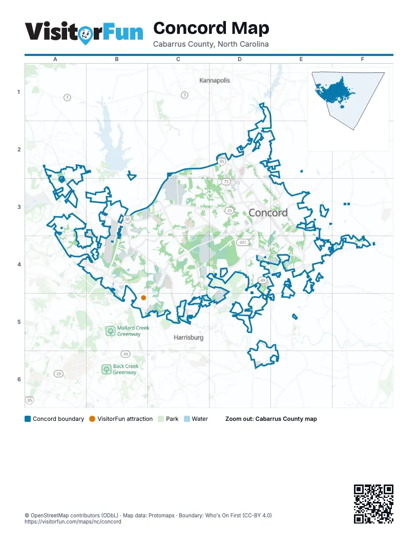
Street index of Concord
Each street on the sheet and the grid squares it crosses.
- Concord Parkway SouthD3, B4, C4, D4, B5
- George W. Liles ParkwayC3, C4
- Concord Parkway NorthD2, D3
- Warren C. Coleman BoulevardD3, D4, E4
- Davidson HighwayA2, B2, C2, D2, D3
- Cabarrus Avenue WestD3
- Union Street SouthD3, E3, E4
- Branchview Drive SoutheastE3, E4
- Branchview Drive NortheastD2, D3, E3
- Corban Avenue SoutheastD3, E3
- Stough RoadC4, D4, D5
- Warren C. Coleman Boulevard NorthD3
- Sherwood Court NorthwestD3
- NC 49D4
- South Cannon BoulevardD2
- Concord Lake RoadD2
- Kannapolis ParkwayC3
- Lake Concord Drive NortheastD2
- Poplar Tent RoadA2, A3, B3, C3, D3
- Weddington RoadC3, D3, B4, C4
- Derita RoadB3, A4, B4
- Bruton Smith BoulevardB4, B5
- Old Charlotte Road SouthwestD3, D4
- Church Street NorthD2, D3
- Rock Hill Church RoadC3, D3
- Concord Mills BoulevardA4, B4
- Copperfield Boulevard NortheastD2
- Kannapolis HighwayD2
- Lake Concord Road NortheastD2, D3
- McGill Avenue NorthwestD3
- Cox Mill RoadA3, A4, B4
- Old Salisbury-Concord RoadE2, E3
- Odell School RoadB3
- Cabarrus Avenue EastD3, E3
- Church Street NortheastD3
- Dale Earnhardt BoulevardD2
- Davidson Drive NorthwestD2, D3
- Mall Drive NortheastD2
- Christenbury ParkwayA4
- Concord Mills Boulevard / Bruton Smith BoulevardB4
- Church Street SoutheastD3, E3
- McGill AvenueD3
- Harris RoadA3
- Weddington Road NorthwestC3, B4
- Huntersville-Concord RoadA3
- Roberta RoadC4, D4, C5
- Pitts School Road NorthwestB3, B4, C4
- Pitts School Road SouthwestC4, C5
- Burrage Road NortheastD2, E3
- Central Drive NorthwestD2, D3
- Wilshire Avenue SouthwestE3, D4, E4
- Old Airport RoadE4, F4
- Morehead RoadB5, C5
- Spring Street SouthwestD3, E3, E4
- International Drive NorthwestC2, C3
- Harris Street NorthwestD3
- Rocky River RoadD5, D6
- Winecoff Avenue NorthwestD3
- Winecoff School RoadD2, D3
- Spring Street NorthwestD3
- Kerr Street NorthwestD3
- Zion Church RoadD4, E5
- Cochran RoadC5
- Corban Avenue SouthwestD3
- Central Heights DriveD4, D5, E5
- Clarke Creek ParkwayA3, A4
- Buffalo Avenue NorthwestD3
- Goodman RoadB3
- Lawndale Avenue SoutheastE3, E4
- Union Street NorthD3
- Thunder Road NorthwestB4
- Ellenwood RoadA3
- Millstream Ridge DriveA4
- Stewart Street NorthwestD2
- Broad Drive SouthwestD3, E3
- Poplar Crossing Drive NorthwestC3
- Vinehaven Drive NortheastD2
- Winecoff Avenue NortheastD3
- Roxie StreetD2
- Tremont Avenue NorthwestD2
- Centergrove RoadD1
- South Ridge AvenueD2
- Christenbury RoadA4
- Flowes Store RoadE4
- Midlake AvenueD1
- Cold Springs RoadF4
- Gold Hill RoadE3
- Drake Mill LaneE5, D6, E6
- Union Cemetery Road SouthwestD3, D4
- Ten Tenths Motor ClubB5
- Eva Drive NorthwestC3, D3
- Sandy Bottom Drive NorthwestA3
- Concord Farms RoadC3, C4
- Glen Haven Drive SouthwestC4
- Charlotte Motor SpeedwayB4, B5
- Wyoming Drive NorthwestC3
- Jackson Terrace SouthwestD4
- Charlotte Motor Speedway RovalB5
- Clover Road NorthwestB4
- Wrangler Drive SouthwestC4, C5
- Bridlewood Place NortheastD2, E2
- Sunderland Road SouthwestD3, D4
- Georgia Street SouthwestD3, D4
- Moss Plantation Avenue NorthwestA2
- Hector Henry Greenway Service RoadD5, E5, D6
- Saddlewood Circle SouthwestD4
- Montford Avenue NorthwestC3, D3
- Chadbourne Avenue NorthwestC2, C3
- Amarillo Drive SouthwestC4, C5
- Falling Leaf DriveA3
- Brookwood Avenue NortheastD3, E3
- Blume Avenue SouthwestE3, D4, E4
- Holden AvenueD6
- Miramar Street NortheastD2, D3
- Pebblebrook Circle SouthwestC4, D4, C5, D5
- Bennington Drive NorthwestB3, C3, B4, C4
- Channing Circle NorthwestC3
- Lucky Drive NorthwestC3, D3
- River Oaks Drive NorthwestA2, A3
- Ravenscroft Lane NorthwestA2
- Gibson Drive NorthwestD3
- Lincoln Street SouthwestD3, D4
- Farm Lake Drive SouthwestD4
- Lily Green Court NorthwestA4, B4
- Chelwood Drive NorthwestC3, D3
- Crestside Drive SoutheastE3
- Wilhelm Place NortheastD2
- Sutro Forest Drive NorthwestA3
- Plantation Road NorthwestB4, C4
- Triumph Drive SouthwestC4, C5
- Kings Crossing Drive NorthwestC3
- Aviation Boulevard NorthwestB4
- Fryling Avenue SouthwestE4
- Ruebens Road SouthwestD4
- Wilburn Park LaneA3, A4
- Grand Canyon Road NorthwestC3
- Hunton Dale Road NorthwestC3
- Kellybrook DriveE4, E5
- Falls Lake Drive SouthwestD5
- Eastcliff Drive SoutheastE3, E4
- Old Trace Road NorthwestA3
- Hillandale Street NortheastD3
- Gateway Lane NorthwestB4
- Weldon Circle NorthwestB3, B4
- Monticello Drive NorthwestB4, C4
- Manor Avenue SouthwestE4
- Abington Drive NortheastD2, E2
- Groff Street NorthwestD3
- Old Speedway Drive NorthwestC3
- Crowell Drive SouthwestD3
- Woodend Drive SoutheastE3
- Palaside Drive NortheastD2, D3
- Williamsburg Drive NortheastD2
- Camrose Circle NortheastD3
- Hearth Lane SouthwestD5
- Krimminger Avenue SoutheastE4
- Ikerd Drive SoutheastE3, E4
- Wheat Drive SouthwestC5
- Faith Drive SouthwestD4
- Papa Joe Hendrick BoulevardB4, B5
- Melrose Drive SouthwestD3
- Motorsports Drive SouthwestD4, D5
- Franklin Avenue NorthwestD3
- Rembrandt Drive SouthwestD4
- Georgetown Drive NorthwestC3
- Winfield Boulevard SoutheastE3
- Sunnyside Drive SoutheastE3
- Honeycutt Drive SoutheastE3
- Crestmont DriveE3, E4
- Highland Avenue SouthwestD4
- Patricia Drive NorthwestC3
- Ivey Cline RoadB3, B4
- Grandview Drive NortheastD2, D3
- Green Street SouthwestD4
- Red Bird Circle SoutheastF4
- Falcon Chase Drive SouthwestC4, C5
- Elm Avenue NorthwestD3
- Scarbrough Circle SouthwestD6
- Morris Burn Drive SouthwestC5
- Wilson Street NortheastD3, E3
- Eastover Drive SoutheastE3
- Goldrush DriveE3
- Stream Dale Circle NorthwestC3
- Deal Street SoutheastE3
- Harrison Drive NorthwestC3
- Walter Drive NorthwestC3, D3
- Brookwood Avenue NorthwestD3
- Caldwell Drive SoutheastE3
- Branson Road NorthwestC2, C3
- Havenbrook Way NorthwestC2, D2
- Covington Drive NorthwestC4
- South Circle NorthwestD2
- Quay RoadB4
- Academy Avenue NorthwestD3
- Montrose DriveA3, A4
- Christenbury Hall Court NorthwestA4
- Derby Lane NorthwestB3
- Hanover Drive NorthwestC2, C3
- Charlotte Motor Speedway Karting TrackB5
- Waterlynn Circle NorthwestB4
- Central Cabarrus High RoadD4
- Young Avenue SouthwestD3
- Quail Drive NorthwestB4, C4
- Country Club Drive NortheastD2
- Dwight Place SouthwestC4
- Todd Drive NortheastD3
- Crowell Drive NorthwestD3
- Goodman Circle NortheastD2
- Woodland Drive SouthwestE4
- 12th Fairway Drive NorthwestC3, C4
- Holden Avenue SouthwestD5, D6
- Sycamore Ridge Road NortheastD2
- Overbrook Drive NortheastD2
- Middlecrest Drive NorthwestA2, A3
- Hunton Forest Drive NorthwestC3
- Stonecrest Circle SouthwestD4
- Haddington DriveA3, A4
- Chapel Creek Road SouthwestD5
- Swink Street SouthwestD3, D4
- Hedgemore Court SouthwestC4
- Kingfield Drive SouthwestD4
- Vance Drive NortheastD3
- Barbee Road SouthwestD4
- Treasure Drive SouthwestD4
- Moss Farm Street NorthwestA2, A3
- Courtney Street SoutheastE3, E4
- Splicewood Drive SouthwestD4
- Piney Church RoadE5
- Victory Lane SouthwestC5
- Yeager Drive NorthwestD3
- Legolas LaneA4
- Captains Watch Road NortheastD1
- Revolutionary Drive NorthwestC3, C4
- Havencrest Court NorthwestB3, C3
- Barrowcliffe Drive NorthwestB4
- Hillcrest Avenue SoutheastE3
- Hyde Park Drive NortheastD3
- Amhurst Street SouthwestD4
- Arlington Avenue SoutheastE3, E4
- Stone Pile DriveD6, E6
- Brookstone Drive NorthwestC4
- Gettysburg Drive NorthwestB4, C4
- Montana Circle NorthwestC3
- Cedar Springs Drive SouthwestC4
- Bridgeford Drive NorthwestA3
- McKinnon Avenue NortheastD3
- Fortune Avenue NorthwestC3
- Main Street SouthwestD4
- Langley Southeast DriveE4, F4
- Deep Cove Drive NorthwestB4
- Zephyr Place NorthwestB4
- Griffins Gate Southwest DriveD6
- Stonewall Circle SouthwestD4
- Edgewater Drive NorthwestC3
- Freeze Avenue NorthwestD3
- Elrond DriveA3
- Ranchway Drive SouthwestC4
- White Street NorthD3
- Wilmar Street NorthwestD3
- Kartey Avenue NorthwestA3
- Pine Circle Drive NorthwestD3
- Hudspeth RoadB5
- Coddle Creek Drive SouthwestC4
- Lynwood Drive NorthwestB4
- Pounds Avenue SouthwestE4
- Waltham CourtA4
- Medical Park Drive NortheastD2
- Heglar RoadE4, F4
- Belt RoadB4
- Firecrest StreetE3
- Chestnut Drive SouthwestD3, E3
- Artdale Road SouthwestC4
- Juanita Drive SouthwestC5
- Asheford Green Avenue NorthwestC3
- Armentrout DriveE4
- Old Farm Road SoutheastE4, F4
- Herringbone Lane NorthwestA3
- Knollcrest Drive NortheastE2
- Sunberry Lane NorthwestC3
- Wendover Road NorthwestD3
- Willow Pound Lane SoutheastE3, E4
- Island Point Drive NorthwestB4
- Lyerly Ridge Road NorthwestB3
- Poplar Station Circle NorthwestB3
- Beverly Drive NortheastD2
- Carolando Drive SouthwestC4
- Chalice Street SouthwestD4
- Woodcrest Drive SouthwestD4
- Champion Lane SouthwestD4
- Fawn Ridge Road NorthwestC3
- Penny Lane NortheastD2
- Garrett Drive SouthwestC4
- Ingleside Drive SoutheastE3
- Cedar Drive NorthwestD3
- Sylvan Street SouthwestE4
- Old Plantation Drive SouthwestD4
- Clearwater Drive NorthwestB4
- Tarrymore Lane SouthwestD4
- Glenwood Drive SouthwestD4
- Enterprise Drive NorthwestC3
Things to do on the Concord map
Places on the map
- (Neighborhood)
- Alfred M. Brown Operations Center
- Atrium Health Cabarrus
- Atrium Health Cabarrus Heliport
- Bass Pro Shops
- Bexley Village
- Brown Mill Mountain Bike Trail
- Buffalo Ranch Lake
- Cabarrus Country Club
- Cabarrus Quarry
- Cannon School
- Carolina Mall
- Central Cabarrus High School
- Charlotte Motor Speedway
- Charlotte Motor Speedway Landfill
- Christenbury
- Christenbury Corners
- Christie's
- Concord Commons
- Concord Mills
- Cox Mill High School
- Dave & Buster's Soccer Complex
- Fullerton
- George W. Liles Greenway
- Hellmann's Family Campground
- I-85 Cabarrus County Rest Area
- James L. Dorton Park
- Jay M. Robinson High School
- Keasler Lake
- Moss Creek
- Moss Creek Nature Preserve
- Oakwood Cemetery
- Parkway Commons
- Rocky River Golf Club
- Turn 1 Campground
- Union Grove Cemetery
- VIP Blue
- Weddington Road Park
- West Cabbarus Church
- Willow Oaks Crossing
Next to Concord
- Harrisburg
- Kannapolis map
© OpenStreetMap contributors, Open Database License, openstreetmap.org/copyright · Map data: Protomaps · Boundary: Who's On First (CC-BY 4.0); Quattroshapes (CC BY 2.0)