

North Carolina map
Cabarrus County map
About 244,925 people live here (Census Bureau, 2024 estimate). The sheet's index lists 75 streets; Mooresville Road, Odell School Road and Poplar Tent Road cross the most grid squares. Things to do inside the boundary: Charlotte Motor Speedway.
Open the map (PDF, US Letter)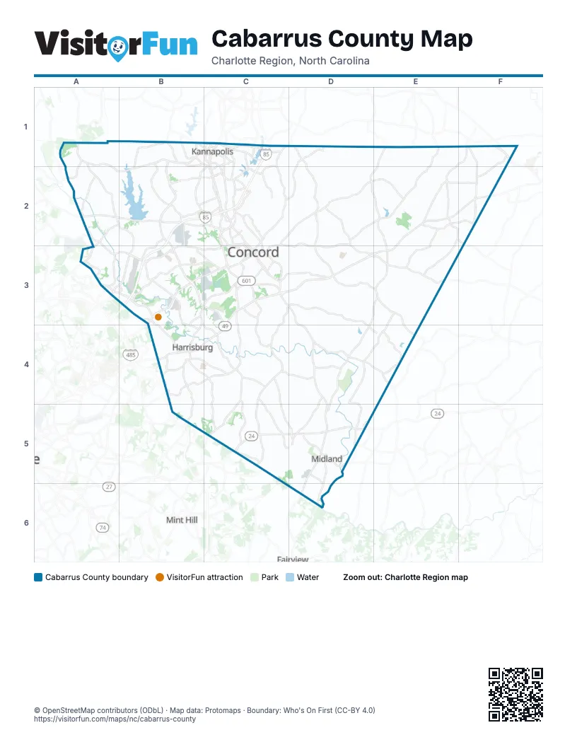
Street index of Cabarrus County
Each street on the sheet and the grid squares it crosses.
- Mooresville RoadA1, B1, C1, A2, B2
- Odell School RoadA1, A2, B2, B3
- Bethpage RoadB1, C1
- Kannapolis ParkwayB1, B2
- Rainbow DriveB1
- Tuckaseegee RoadB1, B2
- West C StreetB1, C1
- Dale Earnhardt BoulevardC1, C2
- East 1st StreetC1
- Jackson Park RoadC1
- Lane StreetC1
- Laureate WayC1
- Loop Road NorthC1
- Martin Luther King, Jr. AvenueC1
- North Cannon BoulevardC1
- North Main StreetC1
- Old Concord RoadC1
- Old Salisbury-Concord RoadC1, C2
- South Cannon BoulevardC1, C2
- South Main StreetC1, C2
- Watson-Crick DrC1
- Davidson HighwayA2, B2, C2
- Harris RoadA2, A3
- Huntersville-Concord RoadA2
- Poplar Tent RoadA2, A3, B3, C3
- Sam Furr RoadA2
- George W Liles ParkwayB2, B3
- Rogers Lake RoadB2, C2
- Branchview Drive NortheastC2
- Branchview Drive SoutheastC2, C3
- Cabarrus Avenue EastC2, C3
- Church Street NorthC2
- Church Street NortheastC2, C3
- Concord Lake RoadC2
- Concord Parkway NorthC2, C3
- Copperfield Boulevard NortheastC2
- Corban Avenue SoutheastC2, C3
- Davidson Drive NorthwestC2
- Kannapolis HighwayC2
- Lake Concord Drive NortheastC2
- Lake Concord Road NortheastC2
- Mall Drive NortheastC2
- McGill AvenueC2, C3
- Christenbury ParkwayA3
- Concord Mills BoulevardA3, B3
- Cox Mill RoadA3
- Derita RoadA3, B3
- Eastfield RoadA3
- Bruton Smith BoulevardB3
- Concord Mills Boulevard / Bruton Smith BoulevardB3
- Concord Parkway SouthB3, C3
- George W. Liles ParkwayB3
- Stough RoadB3, C3
- Weddington RoadB3, C3
- Weddington Road NorthwestB3
- Cabarrus Avenue WestC3
- Church Street SoutheastC3
- McGill Avenue NorthwestC3
- NC 49C3, B4, C4
- Old Charlotte Road SouthwestC3
- Rock Hill Church RoadC3
- Union Street SouthC3
- Warren C Coleman Boulevard NorthC3
- Warren C. Coleman BoulevardC3
- Warren C. Coleman Boulevard NorthC3
- NC 73D3, E3
- State Highway 73D3
- East Franklin StreetE3
- West Franklin StreetE3
- NC Highway 49B4
- NC Highway 49 SouthB4
- University City BoulevardB4
- North Central AvenueE4
- Albemarle RoadC5
- West Main StreetD5
Things to do on the Cabarrus County map
Places on the map
- (Neighborhood)
- Afton Ridge
- Afton Village
- Allee'Bubba Farms
- Asheford Green
- Atrium Health Cabarrus
- Austin Corners
- Bexley Square at Concord Mills
- Bexley Village
- Brentridge
- Briarcrest
- Brown Mill Mountain Bike Trail
- Buffalo Ranch Lake
- Cabarrus Country Club
- Cabarrus County
- Cabarrus Crossing
- Cabarrus Quarry
- Cabarrus Youth Development Center
- Camp Spencer Park
- Cannon School
- Carolina Court
- Carolina Intl School
- Carolina Mall
- Carolina Memorial Park
- Carriage Downs
- Cedar Springs
- Central Cabarrus High School
- Century Afton Ridge
- Chadbury
- Charity Baptist Church
- Charlotte Motor Speedway
- Charlotte Motor Speedway Landfill
- Cherry Grove
- Christenbury
- Christenbury Corners
- Christie's
- Concord
- Concord Commons
- Concord Mills
- Concord Ridge Apartments
Next to Cabarrus County
- Fairview
- Mint Hill
© OpenStreetMap contributors (ODbL) · Map data: Protomaps · Boundary: Who's On First (CC-BY 4.0)