

North Carolina map
Charlotte Region map
The sheet's index lists 25 highways; US 74, US 52 and I-85 cross the most grid squares. Things to do inside the boundary: Bechtler Museum of Modern Art, Billy Graham Library and Charlotte Motor Speedway. Also on it: Albemarle, Bessemer City and Charlotte.
Open the map (PDF, US Letter)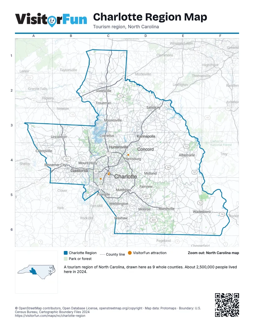
Highway index of Charlotte Region
Each highway on the sheet and the grid squares it crosses.
- I-40B2, C2
- I-77C1, C2, C3, C4, C5
- I-85A4, B4, C4, D2, D3, D4
- I-277C4
- I-485C4, C5, D4, D5
- US 21C3, C4, C5
- US 29A4, B4, D3, D4
- US 52D2, D3, E3, E4, E5, F5, F6
- US 64B2, C2
- US 70C2, D2, D3
- US 74A4, B4, C4, C5, D5, E5, F5, F6
- US 321B3, B4
- US 521C5
- US 601D2, D3, D4, D5, D6
- NC 8E3
- NC 16B3, B4, C4
- NC 24C4, D4, E4
- NC 27B3, C4, C5, D4, E4
- NC 49C4, D3, D4, E3
- NC 73D4, E4
- NC 90C2
- NC 150A4, B3, B4
- NC 200D5
- NC 742E5, F5
- NC 801D2
Things to do on the Charlotte Region map
- Bechtler Museum of Modern Art
- Billy Graham Library
- Charlotte Motor Speedway
- Concord Mills
- Crowders Mountain State Park
- Discovery Place Science
- Freedom Park
- Harvey B. Gantt Center for African-American Arts + Culture
- Lake Norman State Park
- Levine Museum of the New South
- Mint Museum
- Morrow Mountain State Park
- NASCAR Hall of Fame
- SouthPark
- Sullenberger Aviation Museum
Places on the map
- Albemarle
- Bessemer City
- Charlotte
- Cherryville
- Concord
- Cornelius
- Fairview
- Gastonia
- Harrisburg
- Huntersville
- Kannapolis
- Lincolnton
- Marshville
- Matthews
- Midland
- Monroe
- Mooresville
- Mount Holly
- Pineville
- Salisbury
- Statesville
- Troutman
- Wadesboro
- Waxhaw
- Weddington
Next to Charlotte Region
- Asheville & the Foothills map
- Greensboro & Winston-Salem map
- High Country map
- Pinehurst & Sandhills map
- Olde English District
- Pee Dee Country
© OpenStreetMap contributors, Open Database License, openstreetmap.org/copyright · Map data: Protomaps · Boundary: U.S. Census Bureau, Cartographic Boundary Files 2024