

North Carolina map
Cumberland County map
About 338,430 people live here (Census Bureau, 2024 estimate). The sheet's index lists 130 streets; Fayetteville Outer Loop, Dunn Road and Ramsey Street cross the most grid squares. Things to do inside the boundary: Airborne & Special Operations Museum.
Open the map (PDF, US Letter)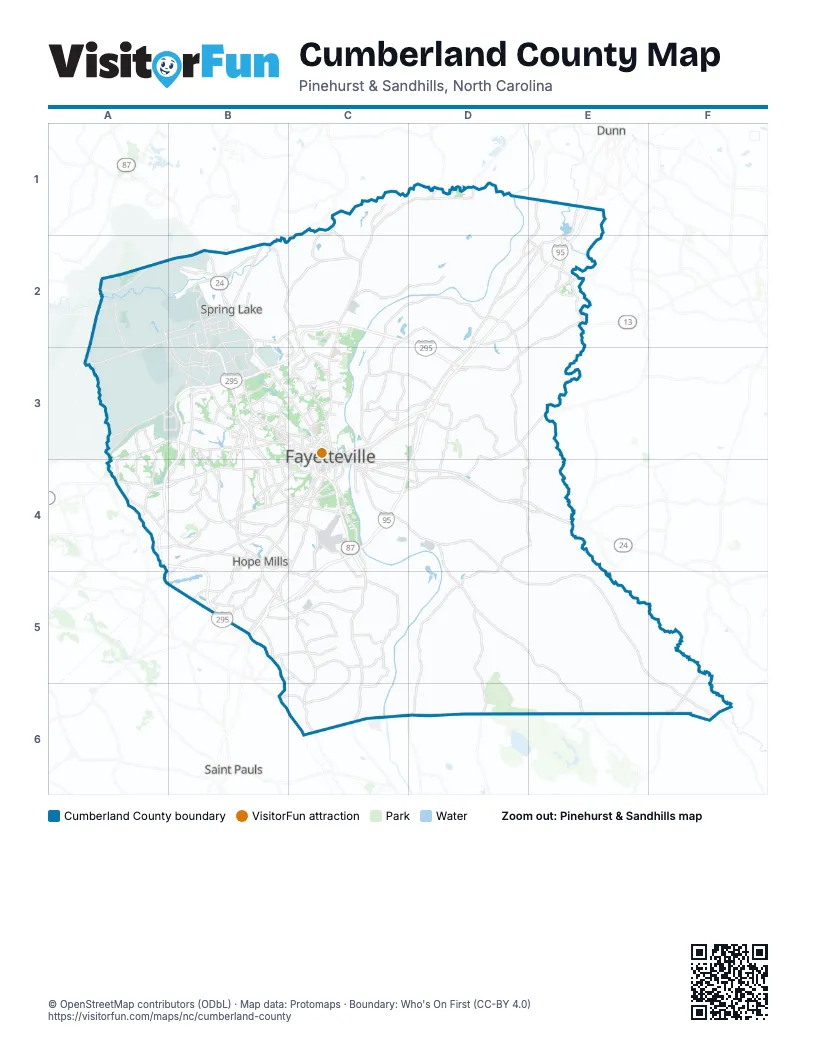
Street index of Cumberland County
Each street on the sheet and the grid squares it crosses.
- Ramsey StreetC1, D1, C2, C3
- Linden RoadD1
- Main StreetD1, E1, D2, E2
- Mill RoadD1
- Burnett RoadE1, E2
- Gruber RoadA2, B3
- Lamont RoadA2, A3
- Longstreet RoadA2, B2, A3
- Manchester Road & Raefordvass RoadA2
- Vass RoadA2, B2
- West Manchester RoadA2, B2
- All American ParkwayB2, B3
- Butner RoadB2
- East Manchester RoadB2
- Honeycutt RoadB2, C2, B3
- Knox StreetB2, B3
- Lillington HighwayB2
- Logistics StreetB2, B3
- Macomb StreetB2
- Manchester RoadB2
- McArthur RoadB2, C2, C3
- McCormick Bridge RoadB2
- Murchison RoadB2, B3, C3
- North Bragg BoulevardB2
- North Main StreetB2, B4
- Randolph StreetB2
- Rock Merritt AvenueB2, B3
- South Bragg BoulevardB2
- South Main StreetB2, B4, B5
- Spring AvenueB2
- Zabitosky RoadB2, B3
- Fayetteville Outer LoopC2, D2, B3, C3, D3, A4, B4, B5
- River RoadC2, C3
- Dunn RoadD2, E2, C3, D3, C4
- Godwin-Falcon RoadE2
- Goldsboro RoadE2, D3
- Herb Farm RoadE2
- North West StreetE2
- South West StreetE2
- Cliffdale RoadA3, B3, A4
- Hoke Loop RoadA3, A4
- Rim RoadA3, A4
- All American FreewayB3, B4
- Bonanza DriveB3
- Bragg BoulevardB3, C3
- Bunce RoadB3, B4
- Cain RoadB3
- Canopy LaneB3
- Fort Bragg RoadB3, C3
- Glensford DriveB3, B4
- Morganton RoadB3, C3
- North McPherson Church RoadB3
- North Reilly RoadB3
- Pamalee DriveB3, C3
- Reilly RoadB3
- Santa Fe DriveB3
- Shaw Mill RoadB3, C3
- Shaw RoadB3
- Skibo RoadB3, B4
- South McPherson Church RoadB3, B4
- South Reilly RoadB3, A4, B4
- Swain StreetB3
- Sycamore Dairy RoadB3
- Yadkin RoadB3
- Arsenal AvenueC3
- B StreetC3, C4
- Country Club DriveC3
- East Dobbin AvenueC3
- Gillespie StreetC3, C4
- Green StreetC3
- Grove StreetC3, C4
- Hay StreetC3
- Highland AvenueC3
- Market SquareC3
- Martin Luther King Jr FreewayC3, C4
- Middle RoadC3
- North Eastern BoulevardC3, C4
- Person StreetC3, C4
- Raeford RoadC3, A4, B4, C4
- Robeson StreetC3, B4, C4
- Rosehill RoadC3
- Rowan StreetC3
- Stacy Weaver DriveC3
- West Dobbin AvenueC3
- West Russell StreetC3, C4
- Murphy RoadD3
- Pembroke LaneD3
- Fayetteville RoadA4
- Gillis Hill RoadA4
- South Raeford RoadA4, B4
- Stoney Point RoadA4, B4
- Bingham DriveB4
- Camden RoadB4, A5, B5
- Cumberland RoadB4, C4
- Elk RoadB4, C4
- George Owen RoadB4
- Glensford RoadB4
- Golfview RoadB4, B5
- Hope Mills RoadB4
- Ireland DriveB4
- Lakeview RoadB4
- Legion RoadB4, C4
- Mid Pine RoadB4, C4
- Natal StreetB4
- Owen DriveB4, C4
- Rockfish RoadB4
- Village DriveB4, C4
- Airport RoadC4
- Black and Decker RoadC4
- Cedar Creek RoadC4, D4, D5, D6
- Claude Lee RoadC4, C5
- Clinton RoadC4, D4, E4
- Doc Bennett RoadC4
- East Mountain DriveC4
- East Russell StreetC4
- Old Wilmington RoadC4
- Research DriveC4, C5
- South Eastern BoulevardC4
- Southern AvenueC4
- Whitfield StreetC4
- Wilmington HighwayC4
- Maxwell RoadD4
- Black Bridge RoadB5
- Chicken Foot RoadB5, C5, C6
- Glenn RoadB5
- Parkton RoadB5
- Sand Hill RoadC5
- Tom Starling RoadC5
- Elizabethtown HighwayF5
- Fayetteville-Wilmington RoadF6
Things to do on the Cumberland County map
Places on the map
- Addison Ridge
- Alexander McArthur
- Amazon Fulfillment Center
- Annie F Morgan
- Annie May Waddell Property
- Area J
- Arnette Park
- Ascot
- Autumn View Apartments
- Barbours Lake
- Bartons Landing Condos
- Baywood Golf Club
- Beaver Creek Pond
- Beaver Run
- Birnam Wood Estate
- Black Ground Bay
- Blanton Green Apartments
- Blounts Ridge
- Bone Creek
- Bonnie Acres
- Bonnie Doone
- Bonnie Doone Lake
- Bordeaux
- Bordeaux Center
- Borden Heights
- Brace Pocosin
- Branson Lake
- Briarcliff Condos
- Briarcreek
- Briarwood Hills
- Bristol Park Apartments
- Britt Lake Apartments
- Broad Acres
- Broadell
- Brookrun
- Buckhead
- Buhmann
- Bushy Lake
- Bushy Lake State Natural Area
- Butler Heights
Next to Cumberland County
- Dunn
- Saint Pauls
© OpenStreetMap contributors (ODbL) · Map data: Protomaps · Boundary: Who's On First (CC-BY 4.0)