

North Carolina map
Gaston County map
About 242,010 people live here (Census Bureau, 2024 estimate). The sheet's index lists 139 streets; Senator Marshall Arthur Rauch Highway, South Main Street and North Main Street cross the most grid squares. Also on it: Adams Bluff, Akers Center and Antelope Drive.
Open the map (PDF, US Letter)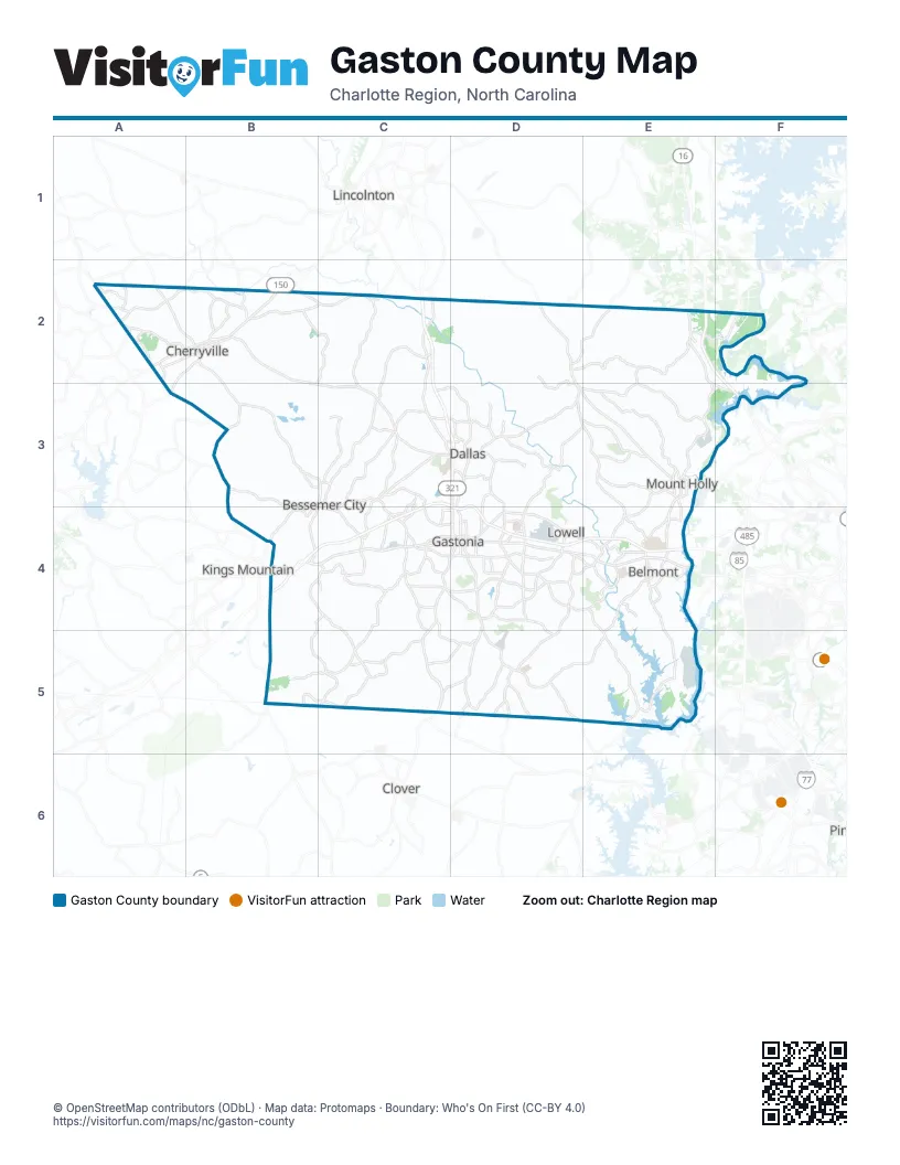
Street index of Gaston County
Each street on the sheet and the grid squares it crosses.
- Cherryville HighwayA2
- Cherryville RoadA2
- North Mountain StreetA2, B2
- Shelby HighwayA2
- West Church StreetA2, B2
- Dallas Cherryville HighwayB2, C3, D3
- East Church StreetB2
- East Main StreetB2
- Lincolnton HighwayB2
- North Rudisill AvenueB2
- South Mountain StreetB2
- Tryon Courthouse RoadB2, B3, C3
- Dallas High Shoals HighwayC2, C3, D3
- North Lincoln StreetC2
- South Lincoln StreetC2
- Charles Raper Jonas HighwayD2, D3, E3
- East Chestnut StreetD2
- North Main StreetD2, E3, D4, E4
- South Main StreetD2, D3, E3, D4, E4
- Lucia Riverbend HighwayE2, F3
- Mountain Island HighwayE2, E3
- County Line RoadB3, B4
- West Pennsylvania AvenueB3, C3
- Bessemer City RoadC3, C4
- Dallas Bessemer City HighwayC3
- East Virginia AvenueC3, C4
- Gastonia HighwayC3, C4
- North 14th StreetC3
- Senator Marshall Arthur Rauch HighwayC3, D3, B4, C4, D4, E4
- South 13th StreetC3
- West Virginia AvenueC3
- Dallas Spencer Mountain RoadD3
- Dallas Stanley HighwayD3
- Dr Martin Luther King Jr WayD3, D4
- East Trade StreetD3
- Friday Park RoadD3
- Gastonia Dallas HighwayD3
- Grier Beam BoulevardD3
- Hickory Grove RoadD3, E3, E4
- Lower Dallas HighwayD3
- Main StreetD3, E4
- North Chester StreetD3, D4
- North Gaston StreetD3
- North Marietta StreetD3
- North New Hope RoadD3, D4
- North Oakland StreetD3
- Old Dallas RoadD3
- Philadelphia Church RoadD3
- Rankin Lake RoadD3
- Ranlo-Spencer Mountain RoadD3
- Sen Marshall Arthur Rauch HighwayD3, D4
- South Gaston StreetD3
- Spencer Mountain RoadD3, D4
- Stanley Spencer Mountain RoadD3, E3
- West Trade StreetD3
- East Charlotte AvenueE3
- Highland StreetE3
- West Charlotte AvenueE3
- Brookshire BoulevardF3
- Bessemer City-Kings Mountain HighwayB4
- Cleveland AvenueB4
- Crowders Mountain RoadB4
- Kings Mountain HighwayB4, C4
- Mountain View RoadB4
- Senator J. Ollie Harris HighwayB4
- Shady Grove RoadB4
- Sparrow Springs RoadB4, C4, B5, C5
- Archie Whitesides RoadC4
- Athenia PlaceC4
- Davis Park RoadC4
- East Alabama AvenueC4
- East Hudson BoulevardC4, D4
- Edgewood RoadC4
- Gaston AvenueC4
- Linwood RoadC4
- North Myrtle School RoadC4
- Shannon Bradley RoadC4
- South 8th StreetC4
- South Chester StreetC4, D4
- South Myrtle School RoadC4
- South York RoadC4
- South York StreetC4, D4
- Stagecoach RoadC4, C5
- West Airline AvenueC4, D4
- West Franklin BoulevardC4, D4
- West Garrison BoulevardC4, D4
- West Hudson BoulevardC4
- York HighwayC4, C5
- Aberdeen BoulevardD4
- Armstrong Park DriveD4
- Armstrong Park RoadD4
- Beaty RoadD4, D5
- Cox RoadD4
- Cramerton RoadD4, E4
- East Franklin BoulevardD4
- East Garrison BoulevardD4
- East Long AvenueD4
- East Ozark AvenueD4
- Hoffman RoadD4
- Kendrick RoadD4, D5
- Lowell Bethesda RoadD4
- Lowell RoadD4
- McAdenville RoadD4, E4
- North Broad StreetD4
- North York StreetD4
- Redbud DriveD4
- Robinson RoadD4, C5, D5
- Robinwood RoadD4
- South Broad StreetD4
- South Marietta StreetD4
- South New Hope RoadD4, E4, E5
- Union RoadD4, D5
- West 1st StreetD4
- West Long AvenueD4
- Westover StreetD4
- Wilkinson BoulevardD4, E4
- 8th AvenueE4
- Academy StreetE4
- Armstrong Ford RoadE4, E5
- Beatty DriveE4
- Belmont Mount Holly RoadE4
- Cameron Morrison BridgeE4
- Carolina Riverside BoulevardE4
- Catawba StreetE4
- Cramer Mountain RoadE4
- Keener BoulevardE4
- Lakewood RoadE4
- Market StreetE4
- Park StreetE4
- Peach Orchard RoadE4
- R L Stowe RoadE4
- Riverside DriveE4
- South Fork ParkwayE4
- South Point RoadE4, E5
- Upper Armstrong BridgeE4
- Wesleyan DriveE4
- York RoadB5
- Armstrong RoadE5
- Pole Branch RoadE5
Places on the map
- Adams Bluff
- Akers Center
- Antelope Drive
- Belmont
- Bessemer City
- Bessemer City Reservoir
- Catawba Creek Golf Course
- Catawba River Greenway
- Cherryville
- Clariant
- Cramer Mountain Club
- Cramerton
- Crowders Mountain State Park
- Dallas
- Dallas Park
- Daniel Stowe Botanical Garden
- Del Webb Carolina Riverside
- Dellview
- Dixie Village Shopping Center
- Downtown Gastonia Historic District
- East Gaston High School
- Eastridge Mall
- Franklin Square
- Freightliner
- G.G. Allen Steam Plant
- Gaston Country Club Lake
- Gaston County
- Gaston Day School
- Gaston Mall Beside Target
- Gaston Memorial Cemetery
- Gastonia
- Gastonia Municipal Airport
- Gateway85 Industrial Park
- George Poston Park
- Goat Island Park
- Gullers Lake
- Hickory Trailer Park
- High Shoals
- Hunter Huss High School
- Lagoon D
Next to Gaston County
- Clover
- Kings Mountain
- Lincolnton
© OpenStreetMap contributors (ODbL) · Map data: Protomaps · Boundary: Who's On First (CC-BY 4.0)