

North Carolina map
Greensboro map
About 307,381 people live here (Census Bureau, 2024 estimate). The sheet's index lists 132 streets; Greensboro Urban Loop, West Market Street and Battleground Avenue cross the most grid squares. Things to do inside the boundary: International Civil Rights Center & Museum.
Open the map (PDF, US Letter)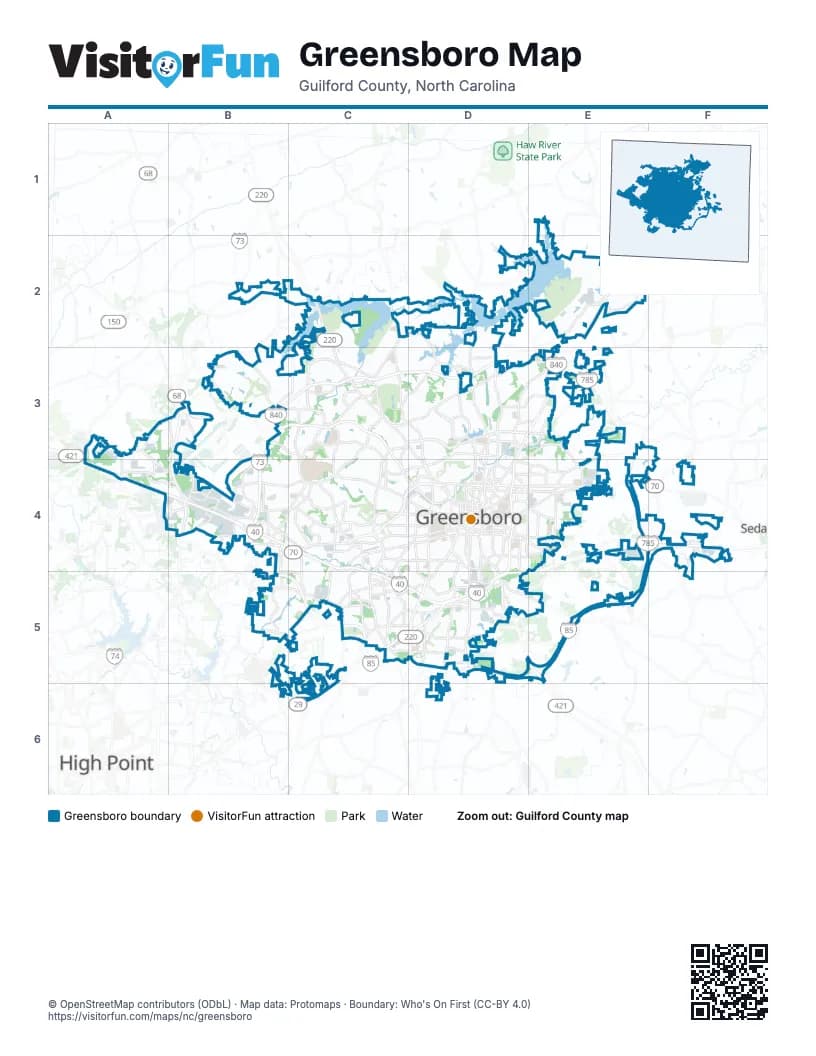
Street index of Greensboro
Each street on the sheet and the grid squares it crosses.
- Pleasant Ridge RoadB2, A3, B3
- Air Harbor RoadC2, D2
- Battleground AvenueC2, C3, D3, D4
- Lake Brandt RoadC2, C3
- Bass Chapel RoadD2, D3
- North O'Henry BoulevardE2, D3, E3, D4
- Reedy Fork ParkwayE2
- Reidsville HighwayE2
- Summit AvenueE2, D3, E3, D4
- Turner Smith RoadE2, F2
- Mc Leansville RoadF2
- East Mountain StreetA3, A4
- Sandy Ridge RoadA3, A4
- West Market StreetA3, A4, B4, C4, D4
- Bryan BoulevardB3, C3, C4
- Fleming RoadB3, C3, C4
- Greensboro Urban LoopB3, C3, D3, E3, B4, E4, F4, B5, C5, D5, E5
- Old Oak Ridge RoadB3, C3
- State Highway 68B3, B4
- Benjamin ParkwayC3, C4, D4
- Lawndale DriveC3, D3, D4
- New Garden RoadC3, C4
- North Holden RoadC3, C4
- Pisgah Church RoadC3, D3
- West Cone BoulevardC3, D3
- Westridge RoadC3, C4
- 16th StreetD3
- East Cone BoulevardD3, E3
- East Cornwallis DriveD3
- Lees Chapel RoadD3, E3
- North Church StreetD3, D4
- North Elm StreetD3, D4
- Yanceyville StreetD3, D4
- Brightwood School RoadE3
- Hicone RoadE3
- Huffine Mill RoadE3, E4
- Salem ParkwayA4
- Albert Pick RoadB4
- Big Tree WayB4, C4
- Bridford ParkwayB4, B5
- Burnt Poplar RoadB4
- Eastchester DriveB4
- Gallimore Dairy RoadB4
- Guilford College RoadB4, C4, B5, B6
- Hickory Ridge DriveB4
- Regional Road NorthB4
- South Regional RoadB4
- West Friendly AvenueB4, C4, D4
- West Wendover AvenueB4, C4, D4
- College RoadC4
- Edwardia DriveC4
- Green Valley RoadC4, D4
- Halifax RoadC4
- Merritt DriveC4, C5
- Muirs Chapel RoadC4
- North College RoadC4
- North Lindell RoadC4
- Patterson CourtC4, D4
- Patterson StreetC4
- South Holden RoadC4, C5
- Spring Garden StreetC4, D4
- West Florida StreetC4, D4
- West Gate City BoulevardC4, D4, B5, C5
- 3rd StreetD4
- Arnold StreetD4
- Battleground CourtD4
- Booker StreetD4
- Coliseum BoulevardD4, D5
- Dick StreetD4
- Duke StreetD4
- East Bessemer AvenueD4, E4
- East Fisher AvenueD4
- East Florida StreetD4, E4
- East Friendly AvenueD4
- East Gate City BoulevardD4, E4
- East Lindsay StreetD4
- East Market St EntD4
- East Market StreetD4, E4
- East McGee StreetD4
- East Radiance DriveD4
- East Side DriveD4
- East Smith StreetD4
- East Wendover AvenueD4, E4
- Freeman Mill RoadD4, D5
- Gorrell StreetD4
- Hackett StreetD4
- Headquarters DriveD4
- Martin Luther King Junior DriveD4, D5
- Murray StreetD4
- North Davie StreetD4
- North Edgeworth StreetD4
- North Eugene StreetD4
- North Josephine Boyd StreetD4
- North Murrow BoulevardD4
- North Spring StreetD4
- Pembroke RoadD4
- Percy StreetD4
- Radiance DriveD4
- Randleman RoadD4, D5
- Secu BoulevardD4
- South Benbow RoadD4
- South Davie StreetD4
- South Edgeworth StreetD4
- South Elm Eugene StreetD4, D5
- South Elm StreetD4
- South Eugene StreetD4
- South Greene StreetD4
- South Josephine Boyd StreetD4
- South Murrow BoulevardD4
- South O'Henry BoulevardD4, D5
- South Spring StreetD4
- Tucker StreetD4
- West Fisher AvenueD4
- West McGee StreetD4
- West Smith StreetD4
- Westover TerraceD4
- Burlington RoadE4, F4
- McLeansville RoadF4
- Mount Hope Church RoadF4
- East Main StreetB5
- Hilltop RoadB5, C5
- Jamestown ParkwayB5
- Creek Ridge RoadC5, D5
- Grandover ParkwayC5, C6
- Groometown RoadC5
- West Vandalia RoadC5, D5
- Wiley Davis RoadC5
- Alamance Church RoadD5, E5
- Governor John Motley Morehead ExpresswayD5
- Industrial AvenueD5
- Joseph M. Hunt Junior ExpresswayD5, E5
- Pleasant Garden RoadD5
Things to do on the Greensboro map
Places on the map
- Adams Lake
- American Hebrew Academy
- Barber Park
- Battleground North Apartments
- Battleground Plaza
- Bellwood Village Apartments
- Benjamin Park Bog Garden
- Birch Creek Ridge
- Bodeaux - Retreat at Jamestown
- Bonset America
- Brandt Village
- Brassfield Park
- Brassfield Shopping Center
- Brookglen Village
- Bryan Park
- Buffalo Lake
- Bur-Mill Park
- Camden Falls Circle
- Cannon Crossing
- Canterbury School
- Carlson Farms Lake
- Cedar Creek Mobile Home Park
- Colonial Pipeline - Greensboro Junction
- Comet Greensboro
- Country Park
- Crystal Lake
- Davidson Place
- Drawbridge Apartments
- Evonik
- Fairfield Lake
- Fellowship Hall
- Fisher Park
- Forest Lawn Cemetery
- Forest Manor Farm
- Four Seasons Town Center
- Friendly Center
- Friends Home
- Garden Creek Center
- Gillespie Golf Course
- Green Hill Cemetery
Next to Greensboro
- High Point
- Sedalia
© OpenStreetMap contributors (ODbL) · Map data: Protomaps · Boundary: Who's On First (CC-BY 4.0)