

North Carolina map
Greensboro & Winston-Salem map
The sheet's index lists 39 highways; US 29, US 421 and I-40 cross the most grid squares. Things to do inside the boundary: Alamance Battleground, Four Seasons Town Centre and Friendly Center. Also on it: Asheboro, Burlington and Clemmons.
Open the map (PDF, US Letter)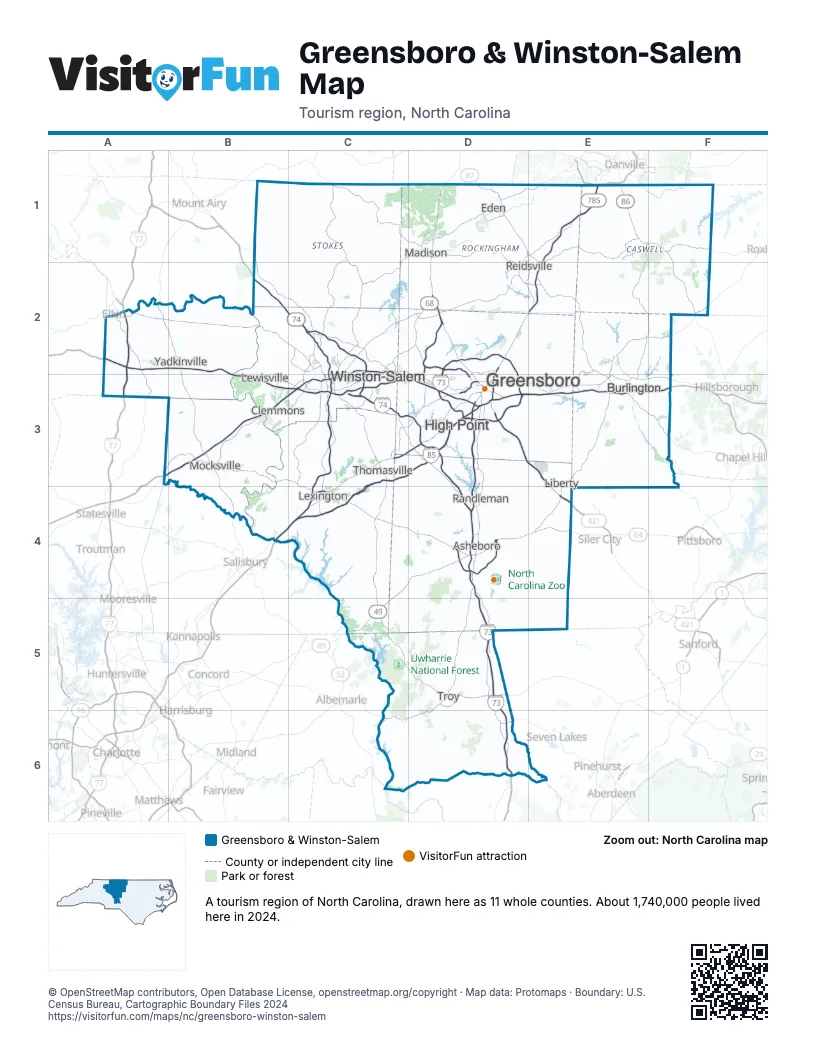
Highway index of Greensboro & Winston-Salem
Each highway on the sheet and the grid squares it crosses.
- I-40A3, B3, C3, D3, E3, F3
- I-73D2, D3, D4, D5, D6
- I-74C2, C3, D3, D4, D5, D6
- I-77A2, A3
- I-85B4, C3, C4, D3, E3, F3
- I-285C3, C4
- I-785D2, D3
- I-840D2, D3
- US 21A2
- US 29B4, C3, C4, D1, D2, D3, E1, E2
- US 52B2, B4, C2, C3, C4
- US 58E1
- US 64B3, C3, C4, D4, E4
- US 70B4, C3, C4, D3
- US 158C2, C3, D2, E1, E2, F1
- US 220D1, D2, D3, D4, D5, D6
- US 311D1
- US 421A2, B2, B3, C2, C3, D3, E3, E4
- US 601B3
- NC 8C2, C3, C5
- NC 14D1, E1, E2
- NC 22E4
- NC 24C6, D5, D6
- NC 27C6, D5, D6
- NC 49C4, C5, D4, E3, E4, F2
- NC 54E3, F3
- NC 62F1
- NC 65D2
- NC 68D2, D3
- NC 73C6
- NC 86E1, F1, F2
- VA 86E1
- NC 87D1, D2, E2, E3
- VA 87D1
- NC 100E2, E3
- NC 109D5, D6
- NC 150C2, C3, D2, E2
- NC 192C3
- NC 770D1
Things to do on the Greensboro & Winston-Salem map
- Alamance Battleground
- Four Seasons Town Centre
- Friendly Center
- Guilford Courthouse National Military Park
- Hanes Mall
- Hanging Rock State Park
- Haw River State Park
- Holly Hill Mall and Business Center
- International Civil Rights Center & Museum
- North Carolina Zoo
- Old Salem Museums & Gardens
- Reynolda House Museum of American Art
- Town Creek Indian Mound
Places on the map
- Asheboro
- Burlington
- Clemmons
- Eden
- Greensboro
- High Point
- Lewisville
- Lexington
- Liberty
- Madison
- Mocksville
- Randleman
- Reidsville
- Thomasville
- Troy
- Winston-Salem
- Yadkinville
Next to Greensboro & Winston-Salem
- Charlotte Region map
- High Country map
- Pinehurst & Sandhills map
- Raleigh, Durham & the Triangle map
- Southern Virginia
- Southwest Virginia - Blue Ridge Highlands
© OpenStreetMap contributors, Open Database License, openstreetmap.org/copyright · Map data: Protomaps · Boundary: U.S. Census Bureau, Cartographic Boundary Files 2024