

North Carolina map
Moore County map
About 108,417 people live here (Census Bureau, 2024 estimate). The sheet's index lists 300 streets; NC 211 Highway, Hoffman Road and Sunset Drive cross the most grid squares. Things to do inside the boundary: Pinehurst Resort and Weymouth Woods-Sandhills Nature Preserve.
Open the map (PDF, US Letter)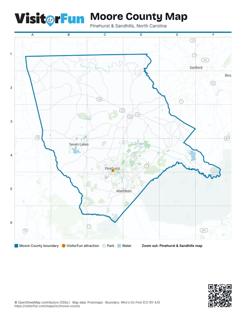
Street index of Moore County
Each street on the sheet and the grid squares it crosses.
- North Sandhills BoulevardD4, D5
- NC 211 HighwayA3, B3, B4, C4
- Glendon Carthage RoadD1, D2, D3
- Midland RoadC4, D4, D5
- NC24-27D3, E3
- NC 24–27 HighwayE3
- East Connecticut AvenueD5
- NC Highway 211D5
- West Pennsylvania AvenueD4, D5
- West Morganton RoadD5
- Yadkin RoadC4, D4, D5
- Monroe StreetD3
- East Massachusetts AvenueD5
- West Connecticut AvenueD4, D5
- South Walnut StreetC5
- Beulah Hill Road SouthC4, C5
- West New York AvenueD4, D5
- Southeast Broad StreetB2, D5
- Carthage StreetE3
- Northwest Broad StreetB2, D5
- Southwest Broad StreetD5
- McReynolds StreetD3
- West New Hampshire AvenueD4, D5
- Beulah Hill Road NorthC4
- Northeast Service RoadD4, D5
- West Massachusetts AvenueD4, D5
- South Sandhills BoulevardC5, D5
- North Walnut StreetC5
- West Vermont AvenueD4, D5
- Old US Highway 1D5
- East Vermont AvenueD5
- Northeast Broad StreetD5
- East New Hampshire AvenueD5
- East New York AvenueD5
- US 15, US 501D3
- East Pennsylvania AvenueD5
- Poindexter StreetD5
- West South StreetD5
- Courthouse SquareD3
- Aberdeen RoadD5
- Pinehurst RoadC5
- White Hill RoadE2
- US 5, US 501D3
- Hoffman RoadB4, B5, B6, C6
- Lobelia RoadE4, F4, F5
- Union Church RoadD3, E3, E4
- NC 73B4, C4
- Morganton RoadB4, C5, D5
- NC-22D3, D4
- North May StreetD4, D5
- Main StreetC4, E4
- Central DriveD4
- South McNeill StreetD3
- Morrison Bridge RoadE4
- Cherokee RoadC4, D4
- South Middleton StreetB2
- South Bennett StreetD5
- Southeast Service RoadD5
- North Bennett StreetD5
- East Morganton RoadD5
- South May StreetD5
- Palmetto RoadC4
- Azalea RoadC4, D4
- North Middleton StreetB2
- Vass RoadF5
- East Salisbury StreetB2
- Jefferson Davis HighwayE3
- Siler City Glendon RoadD1
- Dowd RoadC3, D3, C4
- Niagara Carthage RoadD3, D4
- Spies RoadA2, B2
- Airport RoadC4, D4
- Carthage RoadC3, B4, C4
- Murdocksville RoadC3, C4
- Roseland RoadB5, C5
- Mount Carmel RoadC2, C3
- Bethlehem Church RoadC3, D3
- Underwood RoadD2, E2
- Old River RoadD2, D3
- South Carbonton RoadD1, D2
- Plank RoadB2, C2
- Thunder RoadC5, B6, C6
- Linden RoadC4, C5
- Dover Church RoadA1, A2
- North Moore RoadC1, B2, C2
- Stanton Hill RoadE2, E3
- Cypress Church RoadE4, F4
- Camp Easter RoadD4, E4
- Farm Life School RoadD3, D4
- North Howard Mill RoadB1, B2
- East Indiana AvenueD5
- Cranes Creek RoadE3, E4
- Rose Ridge RoadB5, C5
- Foxfire RoadB5, C5
- South Plank RoadE2, E3
- Adams RoadA1, A2
- McCaskill RoadC4, D4
- Needham Grove RoadB1, B2
- Juniper Lake RoadC4
- Holly Grove School RoadB3, C3, B4
- Red Hill RoadD3, E3
- Atkins RoadE3, E4
- George P RoadB1, C1
- Old Carthage RoadB3, C3
- Torchwood RoadD2, E2
- Busbee RoadA1, B1
- McLauchlin RoadE4
- Pee Dee RoadD4, D5
- Cedar Hill RoadB1
- Saint Andrews DriveC4, C5
- Willie RoadA2
- Summer Hill Church RoadC3, D3
- Diamondhead Drive SouthC5
- Burning Tree RoadC5
- McPherson RoadF4
- Jason RoadA2
- North Fort Bragg RoadD5
- Harrington RoadD1, D2
- Valley View RoadD4
- Seven Lakes DriveB4, C4
- Talc Mine RoadB2
- Sand Pit RoadC5
- Boys Camp RoadE3, E4
- North Poplar StreetD5
- Priest Hill RoadD3
- Monticello DriveC5
- Carolina RoadD5, D6
- Bethesda RoadD5
- Fairway DriveC4, D4
- South Carlisle StreetD5
- Marks RoadF4
- Hardee LaneD4
- Brewer RoadA2, A3
- Pinehurst AvenueD3, D5
- Midway RoadD5
- Carolina Green ParkwayD5
- Shady Lane RoadD3
- Saunders BoulevardD5
- Bibey RoadD3, D4
- Brucewood RoadD5
- Page RoadC4, D5
- Thurlow Lake RoadE4
- North Knoll RoadD4
- South Knoll RoadD4
- Longleaf Drive EastC4
- Community RoadB3, C4
- Spring Lake DriveC4
- Farrell ParkwayC5
- Murray Hill RoadD5
- Magnolia RoadC4
- North Alma StreetE4
- West Baltimore AvenueC5
- McKenzie Road WestC4
- South Pinehurst StreetC5, D5
- Bass RoadE3
- Pine Vista DriveC5
- South Fort Bragg RoadD5
- East Main StreetD5
- Pinecrest School RoadD4, D5
- Legion Hut RoadD3
- Mill Creek RoadD4
- Memorial DriveC4
- Voit Gilmore LaneC4, D4, C5
- Holly RoadD4, E4
- Goldston RoadD1
- Gun Club RoadC4
- Dundee RoadC4
- Calloway RoadD5
- Martin StreetD3
- North Ridgecrest StreetC5
- Lake Forest DriveC4, C5
- Summitt StreetD3
- Rattlesnake TrailC4
- Barrett Road EastC4
- Bethesda AvenueD5
- Old Plank RoadB2
- Rowe StreetC5
- Chinquapin RoadC4
- Fields RoadC4
- Blue StreetD5
- McCaskill Road EastC4
- High Falls RoadB2
- Poverty Hill CircleD4
- South Poplar StreetD5
- Village Green Road WestC4
- West Main StreetD5
- Pine Tree RoadC5
- Lake Hills CircleC5
- Nicholson RoadE3
- South Connecticut AvenueD4
- Erect RoadB1
- McLaughlin RoadE4
- Steed RoadA2
- Steel Bridge RoadD1
- Vass-Carthage RoadD3, D4, E4
- Youngs RoadD4, E4, D5
- Samarcand RoadA3, B3, A4
- Longleaf DriveB4
- Lakebay RoadE4
- Jackson Springs RoadB4, B5
- Kelly Plantation RoadC2, D2, C3
- Beulah Hill Church RoadC3, C4
- River RoadC1, D1, E4
- Putnam Glendon RoadC1, D1, C2
- Big Oak Church RoadB2, B3
- Tarry Church RoadA2, A3
- Old Glendon RoadD2, D3
- Lake Dornoch DriveC5, D5
- Joel RoadD3
- Bensalem Church RoadB3
- Cool Springs RoadC1, C2, D2
- Wadsworth RoadD2
- Flowers RoadB3, B4
- Dan RoadB1, A2, B2
- Borden RoadC2
- Currie Mill RoadB4
- Browns Mill RoadB2
- Wilson RoadC1, C4
- National DriveC4, D4, C5
- Aiken RoadD4, E4
- Meyer Farm DriveD4
- Sunset DriveB2, C3, D3, D4
- Upper RoadA1
- Alton RoadB2, B3
- Juniper Creek BoulevardC4, D4
- Addor RoadC6
- McGill RoadE4, F4
- Fire Tower RoadB3, C3
- Loblolly DriveE4, F4
- Firetree LaneB3, B4
- Martin RoadB4
- Reynolds Mill RoadB1, B2
- Lamms Grove RoadD2, D3, E3
- McDuffie RoadB3
- Mill RoadB4, D5
- Pine Ridge DriveD4, B5
- Leaman RoadB1, B2
- Rascob RoadD1
- Fort BraggE4, D5
- Haw Branch RoadD1
- Pineywood Church RoadE3
- Eagle Branch RoadB3, A4, B4
- Rays Bridge RoadD4
- Pine Grove Church RoadB2
- Odell RoadB1
- Smyrna Church RoadB1, B2
- Richmond RoadB5
- Caviness RoadB1
- West Chrisco RoadA1
- Plantation DriveD4, D5
- Lakeview DriveD4, C5
- Browers Mill RoadA2, B2
- Furr RoadD4, E4
- Ring RoadD3, E3
- Shaw RoadD3
- Lakey Siding RoadB2, C2
- Tufts Vista RoadB5
- Ritter RoadC2
- Red Branch RoadD2, D3
- County Line RoadE3
- Skill RoadB3
- J Dowdy RoadC2, C3
- Sandy Springs RoadD5
- Hulsey RoadD3
- Hemp StreetB2, C2
- Gurney West RoadB2
- Bryant RoadD3
- Eagle Springs RoadB3
- Esther RoadC4
- White Rock RoadE4
- Derby RoadB4, B5
- Brinkley RoadC3, D3
- Peace RoadC3
- Chicken Plant RoadC4
- Putnam Church RoadC2
- Robert RoadA4, B4
- Woodland CircleB5, C5
- Crabtree RoadC2
- Lucas RoadB4
- Riverbirch DriveE4
- Avenue of the CarolinasD4
- Yow RoadA1, B1
- Bascom Chapel RoadA2, B2
- Pinebluff Lake RoadC5, D5
- Lamms RoadC3
- East Chrisco RoadA1, B1
- Baker RoadE4
- Jesse Phillips RoadC1, D1
- Browns Chapel RoadB2
- Kelly RoadD3, E3, C4
- Pinewild DriveC4
- West Devonshire AvenueB4
- Hinson RoadC2
- Leach RoadA2, A3
- Palomino RoadB3
- Inverrary RoadC4, C5
- Mack RoadA1, A2
- Stoneykirk DriveC4
- Flint Hill Church RoadB2, C2
- Palmer DriveD4
Things to do on the Moore County map
Places on the map
- 7 Lakes Golf Club
- Aberdeen
- Cameron
- Cameron Boys Camp
- Camp Durant
- Camp Reeves
- Carthage
- Crystal Lake
- Dormie Club
- Foxfire
- Goodwin State Forest
- Grey Fox
- Holly
- Hyland Golf Club
- Lake Auman
- Lake Nello Teer
- Lake Surf
- Lake Troy Douglas
- Legacy Golf Links
- Little River Golf Course
- Longleaf Golf & Family Club
- Magnolia
- Managed Tree Farm
- Maples
- Mid Pines
- Mid South Club
- North Course
- Pages Lake
- Palmer
- Pine Lake
- Pine Needles
- Pinebluff
- Pinehurst
- Pinehurst Course No. 6
- Pinehurst Course No. 8
- Pinehurst Course No. 9
- Pinehurst Course No.1
- Pinehurst Course No.7
- Pinehurst Harness Track
- Pinehurst Lake
Next to Moore County
- Sanford
© OpenStreetMap contributors, Open Database License, openstreetmap.org/copyright · Map data: Protomaps · Boundary: Who's On First (CC-BY 4.0); Quattroshapes (CC BY 2.0)