

North Dakota map
Grand Forks County map
About 73,771 people live here (Census Bureau, 2024 estimate). The sheet's index lists 300 streets; State Highway 18, 20th Street Northeast and 6th Avenue Northeast cross the most grid squares. Things to do inside the boundary: Grand Cities Mall.
Open the map (PDF, US Letter)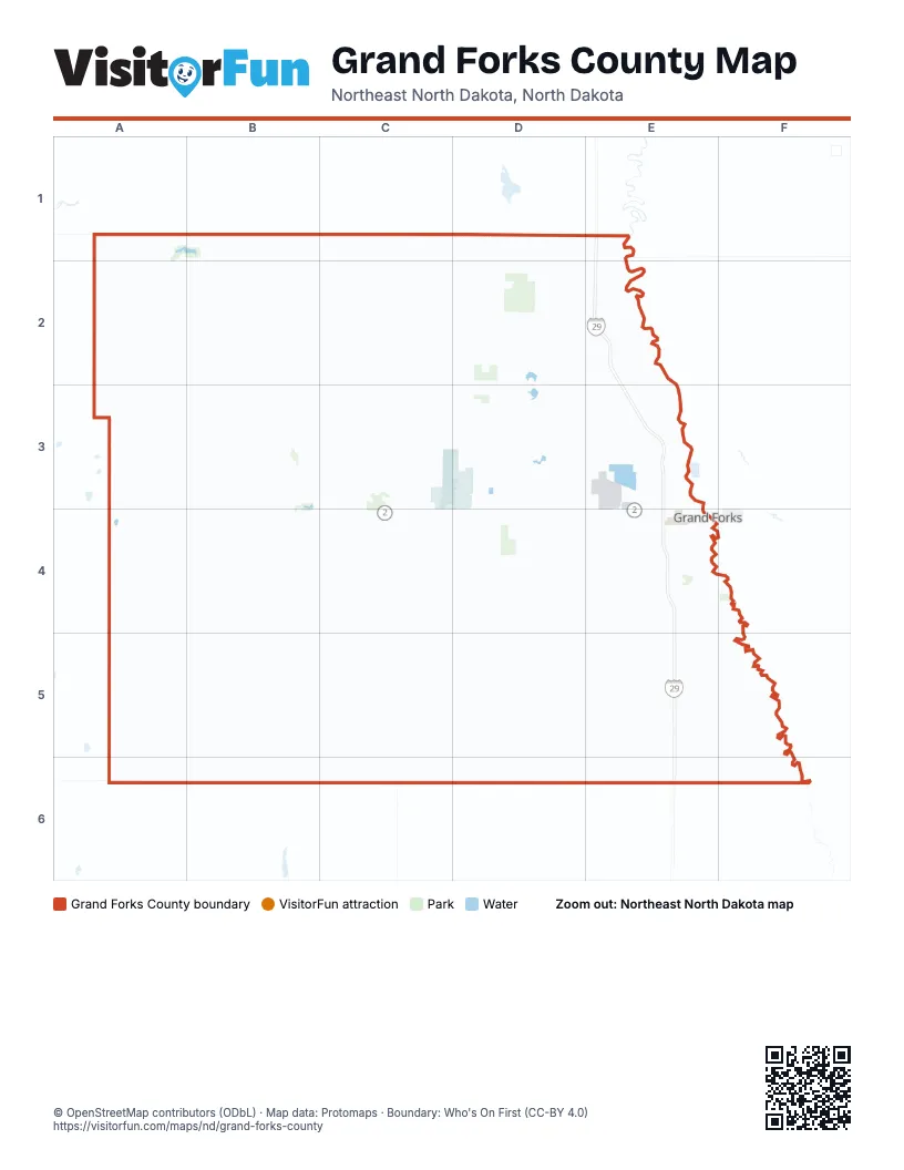
Maps inside Grand Forks County
2 maps inside, from the street map of Grand Forks County down.
City
Street index of Grand Forks County
Each street on the sheet and the grid squares it crosses.
- State Highway 15A5, B5, C5, D5, E5
- State Highway 18B1, B2, B3, B4, B5, C5, C6
- 18th AvenueC4, D4, E4
- 19th Avenue NortheastB3, C3
- Gateway DriveE4
- 32nd Avenue SouthE4
- Demers AvenueE4
- South Washington StreetE4
- North Washington StreetE3, E4
- 23rd AvenueA3
- South 20th StreetE4
- South 34th StreetE4
- South 38th StreetE4
- North 4th StreetE3, E4
- United States Highway 2A3
- North 5th StreetE3, E4
- Towner AvenueB4
- South 23rd StreetE4
- North 1st StreetE3, E4
- County Road 33E2
- South 31st StreetE4
- 6th Avenue NortheastA5, B5, C5, D5, E5, F5
- 7th Avenue NortheastA5, B5, C5, D5, E5, F5
- Eagle AvenueB6, C6, E6, F6
- State Highway 32A1, A2, A3
- County Highway 25/ Eagle AvenueC6, D6, E6
- 11th Street NortheastE4, E5, E6
- 10th Street NortheastE4, E5, E6
- South Columbia RoadE4
- South 42nd StreetE4
- North 42nd StreetE3, E4
- North Columbia RoadE3, E4
- 28th Avenue SouthE4
- Airport DriveE3, E4
- County Road 81E5
- Columbia RoadE4
- 26th Avenue SouthE4
- Broadway StreetE5
- Niagara StreetA3
- 280th Street SouthwestF5
- 1st Avenue NortheastA6, B6, C6, D6, E6, F6
- 25th Street NortheastD1, D2, D3, D4, D5, D6
- 23rd Avenue NortheastA3, B3, C3, D3, E3
- 28th Avenue NortheastA2, B2, C2, D2, E2
- 17th Street NortheastE2, D3, E3, E4, E5, E6
- 33rd Avenue NortheastA2, B2, C2, D2
- 35th Street NortheastC1, C2, C3, C4, C5, C6
- 16th Street NortheastE1, E2, E3, E4, E5, E6
- 14th Avenue NortheastA4, B4, C4, D4, E4
- 12th Avenue NortheastC4, D4, E4, F4
- 35th Avenue NortheastA1, B1, C1, D1
- 10th Avenue NortheastA4, B4, C4, E4, B5
- 44th Street NortheastA2, A3, A4, A5
- 22nd Street NortheastD2, D3, D4, D5, D6
- 34th Street NortheastC1, C2, C3, C4, C5, C6
- 41st StreetB3, B4, B5, B6
- 29th Avenue NortheastA2, B2, C2, D2, E2
- County Road 2C1, C2, C3, C4
- 36th Street NortheastB1, B2, B3, B4, B5, B6
- 46th Street NortheastA1, A2, A3, A4, A5
- 15th Street NortheastE1, E2, E4, E5, E6
- 31st Avenue NortheastA2, B2, C2, D2, E2
- 21st Avenue NortheastA3, B3, C3, D3, E3
- 24th Avenue NortheastA3, B3, C3, D3, E3
- 43rd Street NortheastB1, B2, B3, B5, B6
- 47th Street NortheastA2, A3, A4, A5, A6
- 8th AvenueA5, B5, C5, E6
- 32nd Avenue NortheastA2, B2, C2, D2, E2
- 22nd Avenue NortheastA3, B3, C3, D3, E3
- 8th Avenue NortheastA5, D5, E5, F5
- 16th Avenue NortheastA4, B4, C4, D4, E4
- 45th Street NortheastA1, A2, A3, A4, A5, A6
- 24th Street NortheastD1, D2, D3, D4, D5, D6
- 12th Street NortheastE3, E4, E5, E6
- 9th Street NortheastE4, E5, E6
- 42nd Street NortheastB1, B2, A3, E3, B5, B6
- 31st StreetC4, E4, C5
- 17th Avenue SouthE4
- 18th Avenue NortheastA4, B4, C4
- County Road 4D1, D2, B4, C4
- 13th StreetE5, E6
- 31st Street NortheastcC4
- 14th Street NortheastE2, E3, E4
- 62nd Avenue SouthE4
- 26th AvenueA3, B3, E3
- 47th Avenue SouthE4
- Belmont RoadE4
- 37th Street NortheastB5, B6
- University AvenueB2, E4
- 17th AvenueA4, B4, C4
- 41st Street NortheastB1, B2, B3
- 30th Street NortheastC2, C3, C4, C5, C6
- 16th AvenueB4, C4, D4
- Northeast Columbia RoadE4
- 11th Avenue SouthE4
- 13th Avenue SouthE4
- County Road 4AB4
- 3rd StreetB2, C2, E2, A3, E5
- 4th StreetB2, C2, E2, A3, E5
- Highway B3D3, D4
- Western AvenueC2, E2
- North 20th StreetE3, E4
- North 55th StreetE4
- 62nd Avenue SoutheastE4, F4
- County Road 4BB4
- Main StreetD3, D4, C5
- Oldham AvenueE2
- 4th Avenue SouthE4
- South 5th StreetE4
- State Highway 11B3
- Main AvenueC2
- Greatnorth RoadC5
- County Road 12C5
- Great Northern RoadC5
- 1st StreetC2, A3
- Minnesota AvenueE4
- Washington StreetE3
- East Front StreetB4
- Baker AvenueA3
- County Highway 16A6
- County Highway 2F6
- 55th StreetE4
- 51st Street NortheastA2
- County Highway 20B6
- 3rd Avenue NortheastA5, B5, C5, D5, E5, F5
- 4th Avenue NortheastA5, B5, C5, D5, E5, F5
- 11th Avenue NortheastA4, B4, C4, D4, E4, F4
- 2nd Avenue NortheastA5, B5, C5, D5, E5, F5
- 32nd Street NortheastC1, C2, C3, C4, C5, C6
- 18th Street NortheastD2, D3, D4, D5, D6
- 9th Avenue NortheastA5, B5, C5, D5, E5, F5
- 20th Avenue NortheastA3, B3, C3, D3, E3
- 23rd Street NortheastD3, D4, D5, D6
- 27th Street NortheastC1, C2, C3, C4, C5, C6
- 39th Street NortheastB1, B2, B3, B4, B5, B6
- 30th Avenue NortheastA2, B2, C2, D2, E2
- 25th Avenue NortheastA3, B3, C3, D3, E3
- 29th Street NortheastC2, C3, C4, C5
- 20th Street NortheastD1, D2, D3, D4, A5, D5, D6
- 28th Street NortheastC1, C2, C3, C4, C5, C6
- 49th Street NortheastA1, A2, A3, A4
- 26th Street NortheastD1, D2, D4, D5
- 17th Avenue NortheastB4, C4, D4, E4
- 26th Avenue NortheastA3, B3, C3, D3, E3
- 48th Street NortheastA2, A3, A4, A5, A6
- 5th Avenue NortheastD5, E5, F5
- 19th Street NortheastD1, D2, D3, D4
- 34th Avenue NortheastA2, B2, C2, D2
- 33rd StreetC1, C4, C5, C6
- 42nd StreetB2, B3, B4, B5
- 27th Avenue NortheastA2, B2, C2, D2, E2
- 13th Avenue NortheastA4, C4, D4, E4
- 8th Street NortheastF4, F5, F6
- 36th Avenue NortheastB1, C1, D1, E1
- 21st Street NortheastD2, D3, D4, D5, D6
- 40th Street NortheastB2, B3, B5
- 43rd StreetB3, B4, B5
- 15th AvenueA4, B4, C4
- 40th StreetB3, B4, B5
- 69th Street NorthE4, E5, E6
- 15th Avenue NortheastC4, D4, E4
- 33rd Street NortheastC1, C2, C3, C4
- 38th Street NortheastB1, B2, B3, B4
- 19th StreetD4, D5, D6
- 7th Street NortheastF5, F6
- 30th StreetC4, C5
- 10th AvenueA4, C4, D4, E4, F4
- 6th Street NortheastF5, F6
- 12th AvenueB4, C4
- 13th Street NortheastE2, E3, E4
- 49th StreetA4, A5, A6
- 31st Street NortheastC1, C2, C3, C5, C6
- 5th Street NortheastF5, F6
- 70th Avenue NorthE3
- 38th StreetB3, B4, B5
- 28th StreetC4, C5
- 13th AvenueB4, C4
- North 69th StreetE3, E4
- South 69th StreetE4
- South 83rd StreetE4
- 55th Street NorthE3, E4
- 26th StreetD3, D5, D6
- 4th AvenueC5
- Cherry StreetE4
- 24th Avenue SouthE4
- 6th Avenue NorthE4
- Plymouth AvenueA3
- Chestnut StreetE4
- 7th AvenueD3, C5, E5, E6
- 24th StreetD3, D4
- 25th AvenueA3
- 27th Avenue NorthE3
- 36th Avenue SouthE4
- 40th Avenue SouthE4
- Lind Avenue NortheastB5, B6
- 48th StreetA3
- 19th AvenueD3
- Cottonwood StreetE4
- 27th AvenueE2
- 54th Avenue NorthE3
- South 17th StreetE4
- 5th Avenue NorthE4
- Eielson StreetD3
- Oak StreetD4, E4
- 1st AvenueD3, C5
- South 48th StreetE4
- Walnut StreetE4
- 13 Street NortheastE4, E5
- Columbia Road NorthE3
- 2nd StreetB2, C2, A3, E5
- South 10th StreetE4
- 15th Avenue SouthE4
- 35th AvenueE1
- 10th Avenue NorthE4
- 4th Avenue NorthE4
- Park Street NortheastC3, C4
- 8th Avenue NorthE4
- Mill RoadE3, E4
- 14th Avenue SouthE4
- Oak Street NortheastD4
- Jones StreetD3
- South 12th StreetE4
- South 14th StreetE4
- South 19th StreetE4
- 9th Avenue SouthE4
- 7th Avenue SouthE4
- 2nd Avenue NorthE4
- Washington AvenueB4, C4, C5
- North 83rd StreetE3, E4
- 7th Avenue NorthE4
- Liberty LaneE2
- 1st Avenue NorthE4
- Louisiana StreetD3
- MSA Security RoadD3
- South 11th StreetE4
- 9th Avenue NorthE4
- 40th Avenue NorthE3
- 83rd Street NorthE3
- Ashley Lane NortheastF4
- Railroad StreetB4
- Barrett AvenueB4
- Kings View DriveE4
- 8th Avenue SouthE4
- Campus RoadE4
- 10th Avenue SouthE4
- Adams DriveE4, F4
- 20th Avenue SouthE4
- North 6th StreetE3, E4
- Park DriveE2, E4, E5
- North 3rd StreetE3, E4
- Park Avenue NortheastC3, C4
- 44th Avenue SouthE4
- Redwood DriveD3
- South 18th StreetE4
- 12th Avenue NorthE4
- Lincoln DriveE4
- Washington West Frontage RoadE4
- Alert AvenueC3, D3
- Perimeter Security RoadD3, C4, D4
- 3rd AvenueE2, D3, C5
- 22nd Avenue SouthE4
- 11th AvenueC4, E4
- 25th Avenue SouthE4
- South 29th StreetE4
- 34th AvenueE2
- 39th StreetB4
- South 16th StreetE4
- McCanna Street WestB3
- Bible StreetB3
- 55th Avenue SouthE4
- North 97th StreetE3
- 55th Street SouthE4
- Pacific AvenueE5
- Center Avenue NortheastE6, F6
- 50th Street NortheastA2
- Pleasant StreetC5
- 54th Street NortheastA1
- 3rd Street NortheastF6
- Airport Road NortheastB5, C5
- Block Drive NortheastE5
- South 25th StreetE4
- 8th StreetB2, E2, F4, E5
- Woods StreetC3
- South 36th StreetE4
- 45th StreetA4
- South 46th StreetE4
- 6th StreetB2, E2, D4, E5
- 27th Avenue SouthE4
- 11th Avenue NorthE4
- North 43rd StreetE3, E4
- 13th Avenue NorthE4
- Frontage RoadE2
- 30th Avenue SouthE4
- 5th StreetB2, C2, E2, D4, E5
- 12th Avenue SouthE4
- South Washington Street East Frontage RoadE4
- South 15th StreetE4
- 18th Avenue SouthE4
- I StreetD3
- Demers South Frontage RoadE4
Things to do on the Grand Forks County map
Places on the map
- Altru Hospital
- Bellevue Cemetery
- Calvary Cemetery
- Central Park
- Dump
- Ed Bry Wildlife Management Area
- Emerado
- Flying J Travel Center
- Fordville Dam Recreation Area
- Gilby
- Grand Forks
- Grand Forks AFB
- Grand Forks Air Force Base
- Grand Forks Country Club
- Grand Forks County Water Mgmt. Board WMA
- Grand Forks Greenway
- Inkster
- Kellys Slough Reservoir
- King's Walk
- Larimore
- Larimore Dam Recreation Area
- Larimore Municipal Airport
- Lincoln Drive Park
- Lincoln Golf Course
- Little Goose Lake
- Lunby Lake
- Manvel
- MSA Security Road
- Myra Arboretum
- Niagara
- Northwood
- Prairie View Nature Trail/Park
- Prarie Chicken Wildlife Management Area
- Riverside Park
- Smith Lakes
- Stewart Lake
- Thompson
- Train Yard
- Turtle River
- Turtle River State Park
Next to Grand Forks County
- East Grand Forks
© OpenStreetMap contributors, Open Database License, openstreetmap.org/copyright · Map data: Protomaps · Boundary: Who's On First (CC-BY 4.0); Quattroshapes (CC BY 2.0)