

Nebraska map
Lincoln map
About 300,619 people live here (Census Bureau, 2024 estimate). The sheet's index lists 175 streets; Fletcher Avenue, Cornhusker Highway and Homestead Expressway cross the most grid squares. Things to do inside the boundary: Memorial Stadium and Nebraska State Capitol.
Open the map (PDF, US Letter)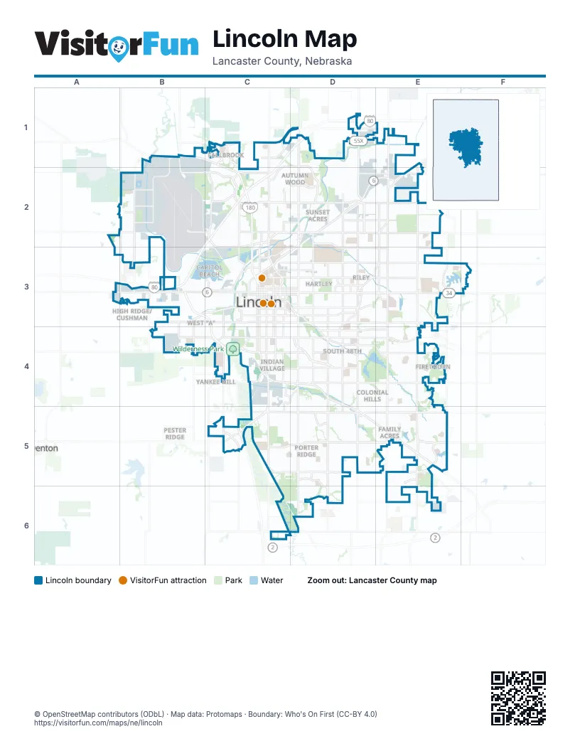
Street index of Lincoln
Each street on the sheet and the grid squares it crosses.
- Northwest 27th StreetB1, B2, B3
- Purple Heart HighwayB1, C1, C2
- West US Highway 34B1
- Wildrose LaneB1
- Alvo RoadC1
- Aster RoadC1
- Centurion DriveC1
- Fallbrook BoulevardC1
- Fletcher AvenueC1, D1, C2, D2, E2
- Humphrey AvenueC1
- North 14th StreetC1, C2, C3
- North 1st StreetC1, C2, C3
- Stonebrook ParkwayC1
- Tallgrass ParkwayC1
- West Alvo RoadC1
- Arbor RoadD1
- North 27th StreetD1, D2, D3
- North 56th StreetD1, D2, D3
- Cornhusker HighwayE1, C2, D2, E2, C3
- North 70th StreetE1, E2, E3
- North 84th StreetE1, E2, E3
- Air Park RoadB2
- Airport RoadB2
- Northwest 31st StreetB2
- Northwest 38th StreetB2
- Northwest 48th StreetB2, B3
- Northwest 56th StreetB2, B3
- West Adams StreetB2, C2
- West Cuming StreetB2
- West Fletcher AvenueB2, C2
- West Knight DriveB2
- West Mathis StreetB2
- Adams StreetC2, D2, E2
- Fairfield StreetC2, D2
- Folkways BoulevardC2, D2
- North 11th StreetC2, C3
- North 20th StreetC2
- North Antelope Valley ParkwayC2, C3
- Northwest 12th StreetC2
- Northwest 13th StreetC2
- Northwest 1st StreetC2
- Superior StreetC2, D2
- West Cornhusker HighwayC2, C3
- West Highland BoulevardC2
- Fremont StreetD2, E2
- Havelock AvenueD2, E2
- Huntington AvenueD2
- Leighton AvenueD2, D3, E3
- North 33rd StreetD2, D3
- North 40th StreetD2, D3
- North 48th StreetD2, D3
- Salt Creek RoadwayD2, C3, D3
- State Fair Park DriveD2
- Theresa StreetD2
- Touzalin AvenueD2
- North 66th StreetE2, E3
- North Cotner BoulevardE2, D3, E3
- West O StreetA3, B3, C3
- Homestead ExpresswayB3, C3, C4, C5
- Northwest 40th StreetB3
- Rosa Parks WayB3, C3
- South Coddington AvenueB3, B4
- Southwest 27th StreetB3, B4
- Southwest 40th StreetB3
- West A StreetB3, C3
- West Holdrege StreetB3
- West Vine StreetB3
- A StreetC3, D3, E3
- B StreetC3
- Capitol Beach BoulevardC3
- Capitol ParkwayC3, D3
- Charleston StreetC3
- D StreetC3, D3
- F StreetC3
- G StreetC3
- Holdrege StreetC3, D3, E3, F3
- J StreetC3, D3
- K StreetC3
- L StreetC3, E3
- Lincoln MallC3
- Line DriveC3
- M StreetC3
- Military RoadC3
- N StreetC3, D3
- North 10th StreetC3
- North 12th StreetC3
- North 13th StreetC3
- North 16th StreetC3
- North 17th StreetC3
- North 4th StreetC3
- North 9th StreetC3
- O StreetC3, D3, E3, F3
- P StreetC3, D3
- Pinnacle Arena DriveC3
- Q StreetC3, D3
- Randolph StreetC3, D3
- South 10th StreetC3, C4
- South 11th StreetC3
- South 12th StreetC3
- South 13th StreetC3, C4
- South 14th StreetC3, C4, C5
- South 16th StreetC3, C4
- South 17th StreetC3, C4
- South 1st StreetC3, C5
- South 20th StreetC3, C4
- South 21st StreetC3
- South 2nd StreetC3
- South 9th StreetC3, C4
- South Antelope Valley ParkwayC3
- South Folsom StreetC3, C4, C5
- South Pinnacle Arena DriveC3
- Southwest 1st StreetC3
- Sun Valley BoulevardC3
- Transformation DriveC3, D3
- Vine StreetC3, D3, E3
- West B StreetC3
- West P StreetC3
- X StreetC3
- Y StreetC3, D3
- Normal BoulevardD3, D4, E4
- North 44th StreetD3
- North 45th StreetD3
- North 46th StreetD3
- North 52nd StreetD3
- R StreetD3
- South 26th StreetD3
- South 27th StreetD3, D4, D5, D6
- South 33rd StreetD3, D4, D5
- South 40th StreetD3, D4, D5, D6
- South 44th StreetD3
- South 48th StreetD3, D4, D5
- South 56th StreetD3, D4, D5
- South Cotner BoulevardD3, D4
- Valley RoadD3
- Haverford DriveE3
- North 98th StreetE3
- South 66th StreetE3
- South 70th StreetE3, E4, E5, E6
- South 84th StreetE3, E4, E5
- Taylor Park DriveE3
- West South StreetB4, C4
- West Van Dorn StreetB4, C4
- Arapahoe StreetC4
- Burnham StreetC4
- Calvert StreetC4, D4
- Essex RoadC4, D4
- Nebraska ParkwayC4, D4, D5, E5
- Park BoulevardC4
- Pioneers BoulevardC4, D4, E4
- South StreetC4, D4, E4
- Southwood DriveC4
- Tipperary TrailC4, D4, C5
- Van Dorn StreetC4, D4, E4
- West Burnham StreetC4
- West Pioneers BoulevardC4
- Sheridan BoulevardD4
- Sumner StreetD4, E4
- Tierra DriveD4
- Glynoaks DriveE4
- Old Cheney RoadC5, D5, E5
- Pine Lake RoadC5, D5, E5
- US Highway 77C5
- Warlick BoulevardC5
- West Amaranth LaneC5
- West Denton RoadC5
- Yankee Hill RoadC5, D5, E5
- Faulkner DriveD5
- South 34th StreetD5
- Wilderness Hills BoulevardD5, D6
- Ashbrook DriveE5
- South 91st StreetE5
- South 98th StreetE5
- Yankee Woods DriveE5
- Rokeby RoadD6, E6
- Saltillo RoadD6
Things to do on the Lincoln map
Places on the map
- 2nd Sheridan Park
- 44 Corporate Place
- 5300 Addition
- 56th Street Lofts & Apartments
- 6th and Van Dorn 2nd Addition
- 84 Lumber
- A Hurlbut's Subdivision
- A. Hurlbut's Subdivision
- Abbott Estates
- Academy Lincoln
- Ada Robinson Elementary School
- Adams Elementary School
- ADM Milling Company
- Adriana Court
- Advantage Trucking
- Adventure Golf Center
- Air Park West
- Airport Entry Corridor
- Alena Court
- Allegrini Terrace
- Allendale
- Allendale Addition
- Allstate Insurance Company
- American Union LLC
- Ames Subdivision
- Amy's
- Anaheim Addition
- Anderson's Place
- Anderson's Tree Farms
- Anna Zeman Elementary School
- Antelope Creek 1st Addition
- Antelope Creek Greenway
- Antelope Gardens
- Antelope Park
- Antelope Park North
- Antelope Park South
- Antelope Pointe
- Appian Way
Next to Lincoln
- Denton
- High Ridge/Cushman
- Pester Ridge
- Yankee Hill
© OpenStreetMap contributors (ODbL) · Map data: Protomaps · Boundary: Who's On First (CC-BY 4.0)