

Nebraska map
Omaha map
About 489,265 people live here (Census Bureau, 2024 estimate). The sheet's index lists 158 streets; West Maple Road, Abbott Drive and Pacific Street cross the most grid squares. Things to do inside the boundary: Joslyn Art Museum, Old Market and Omaha's Henry Doorly Zoo and Aquarium.
Open the map (PDF, US Letter)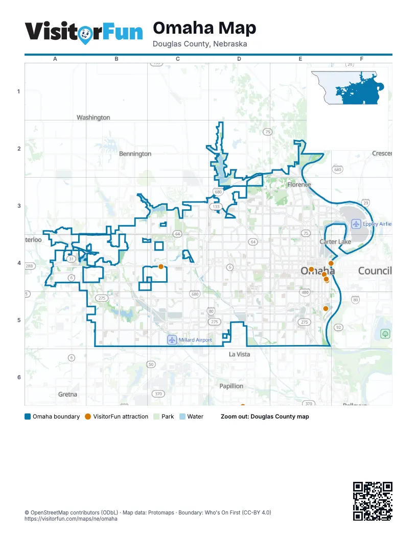
Street index of Omaha
Each street on the sheet and the grid squares it crosses.
- Bennington RoadD2
- Dick Collins RoadE2, E3
- Highway 75E2, E3
- John J Pershing DriveE2, E3
- McKinley StreetE2, E3
- Mormon Bridge RoadE2, D3, E3
- North 31st StreetE2, E3
- North 204th StreetA3, A4
- West Maple RoadA3, B3, C3, A4, B4, C4
- Fort StreetB3, C3, D3
- North 156th StreetB3, B4
- North 168th StreetB3, B4
- Blair High RoadC3, D3
- Ida StreetC3, D3
- Military RoadC3, D3
- North 108th StreetC3, C4
- North 120th StreetC3, C4
- North 132nd StreetC3, C4
- North 144th StreetC3, C4
- State Highway 133C3
- Ames AvenueD3, E3
- Crown Point AvenueD3
- Hartman AvenueD3
- Irvington RoadD3
- Military AvenueD3, D4, E4
- North 60th StreetD3, D4
- North 72nd StreetD3, D4
- North 90th StreetD3, D4
- North 99th StreetD3
- Sorensen ParkwayD3, E3
- Abbott DriveE3, F3, E4, F4
- Arthur C Storz ExpresswayE3, F3
- Commercial AvenueE3
- Craig AvenueE3
- Fontenelle BoulevardE3, E4
- Martin AvenueE3
- North 16th StreetE3, E4
- North 24th StreetE3, E4
- North 30th AvenueE3
- North 30th StreetE3, E4
- North 36th AvenueE3
- North 36th StreetE3
- North 42nd StreetE3, E4
- North 52nd StreetE3, E4
- North FreewayE3, E4
- Terminal DriveF3, F4
- Blondo ParkwayA4, B4
- Pacific StreetA4, B4, C4, D4
- South 204th StreetA4
- West Dodge RoadA4, B4, C4, D4
- Blondo StreetB4, C4, D4, E4
- Bob Boozer DriveB4, B5
- North 180th StreetB4
- North 192nd StreetB4
- South 156th StreetB4, B5
- South 168th StreetB4, B5
- South 180th StreetB4, B5
- South 192nd StreetB4, B5
- California StreetC4, D4, E4
- Maple StreetC4, D4
- North 102nd StreetC4
- North 108th AvenueC4
- Regency ParkwayC4, D4
- South 120th StreetC4, C5
- South 132nd StreetC4, C5
- South 144th StreetC4, C5
- West Dodge Frontage Road NorthC4
- West Dodge Frontage Road SouthC4
- West Dodge Road ExpresswayC4
- 72nd StreetD4
- Beverly DriveD4
- Cass StreetD4
- Dodge StreetD4, E4
- Farnam DriveD4
- Farnam StreetD4, E4
- Leavenworth StreetD4, E4
- North 76th StreetD4
- North 78th StreetD4
- North 84th StreetD4
- Northwest Radial HighwayD4, E4
- Rose Blumkin DriveD4
- South 60th StreetD4, D5
- South 67th StreetD4, D5
- South 72nd StreetD4, D5
- South 78th StreetD4, D5
- South 84th StreetD4, D5
- South 90th StreetD4, D5
- Underwood AvenueD4, E4
- Capitol AvenueE4
- Center StreetE4, D5
- Chicago StreetE4
- Country Club AvenueE4
- Cuming StreetE4
- Douglas StreetE4
- East Locust StreetE4
- Florence BoulevardE4
- Fontanelle BoulevardE4
- Gerald R Ford ExpresswayE4, F4, E5
- Hamilton StreetE4
- Harney StreetE4
- Howard StreetE4
- Lake StreetE4
- Lincoln BoulevardE4
- Locust StreetE4
- North 10th StreetE4
- North 13th StreetE4
- North 14th StreetE4
- North 19th StreetE4
- North 20th StreetE4
- North 40th StreetE4
- North 45th StreetE4
- North Saddle Creek RoadE4
- Saint Mary's AvenueE4
- South 10th StreetE4, E5
- South 13th StreetE4, E5
- South 14th StreetE4
- South 19th StreetE4
- South 20th StreetE4
- South 24th AvenueE4
- South 24th StreetE4, E5
- South 25th StreetE4
- South 28th StreetE4, E5
- South 29th StreetE4, E5
- South 31st StreetE4
- South 32nd AvenueE4, E5
- South 42nd StreetE4, E5
- South 50th StreetE4, E5
- South 51st StreetE4
- South Saddle Creek RoadE4
- Harrison StreetB5, C5, D5, E5
- Industrial RoadB5, C5
- Q StreetB5, C5, D5, E5
- West Center RoadB5, C5, D5
- Giles RoadC5
- I StreetC5
- L StreetC5, D5, E5
- Millard AvenueC5
- South 108th StreetC5
- F StreetD5, E5
- Frederick StreetD5
- Gold StreetD5
- Grover StreetD5, E5
- Main StreetD5
- Mercy RoadD5
- Ridgewood AvenueD5
- South 96th StreetD5
- Bob Gibson BoulevardE5
- Deer Park BoulevardE5
- Ed Creighton AvenueE5
- Kennedy FreewayE5
- Martha StreetE5
- Missouri AvenueE5
- Railroad AvenueE5
- South 26th AvenueE5
- South 36th StreetE5
- South 48th StreetE5
- Veterans Memorial HighwayE5
- Vinton StreetE5
Things to do on the Omaha map
Places on the map
- 'Siderborough
- Adams Park
- Aksarben Drive Grassy Area
- Al Veys Youth Sports Complex
- Altech
- Ambrust Oaks
- Ambrust Oaks Estates
- Applewood Heights
- Arbor Heights
- Armbrusts Rockbrook
- Avenue One Development
- Barrington Park
- Bauermeister Prairie
- Beckwith Place
- Bedford Hill Woods
- Beechwood
- Bel-Air Village
- Benson
- Benson Park
- Benson Park Golf Course
- Bent Creek
- Bent Creek Park
- Bluestem Prairie Preserve
- Bonita
- Bowies Addition
- Bowling Green
- Breckenridge Apartments
- Bridgefords Rockbrook Addition
- Brookhaven Park
- Bryan Park
- Bryn Mawr
- Burke High School
- Burnham Place
- Cambridge Oaks Park
- Candlewood II Park
- Cargo A
- Carter Lake
- Center Park & Armbrust Acres
- Champions Run Country Club
- Charlsew Heights
Next to Omaha
- Bennington
- Carter Lake
- Council Bluffs
- Crescent
- Gretna
- La Vista
- Papillion
- Washington
- Waterloo
© OpenStreetMap contributors (ODbL) · Map data: Protomaps · Boundary: Who's On First (CC-BY 4.0)