

New Jersey map
Bergen County map
About 978,641 people live here (Census Bureau, 2024 estimate). The sheet's index lists 310 streets; River Road, Main Street and Ramapo Valley Road cross the most grid squares. Things to do inside the boundary: American Dream and MetLife Stadium.
Open the map (PDF, US Letter)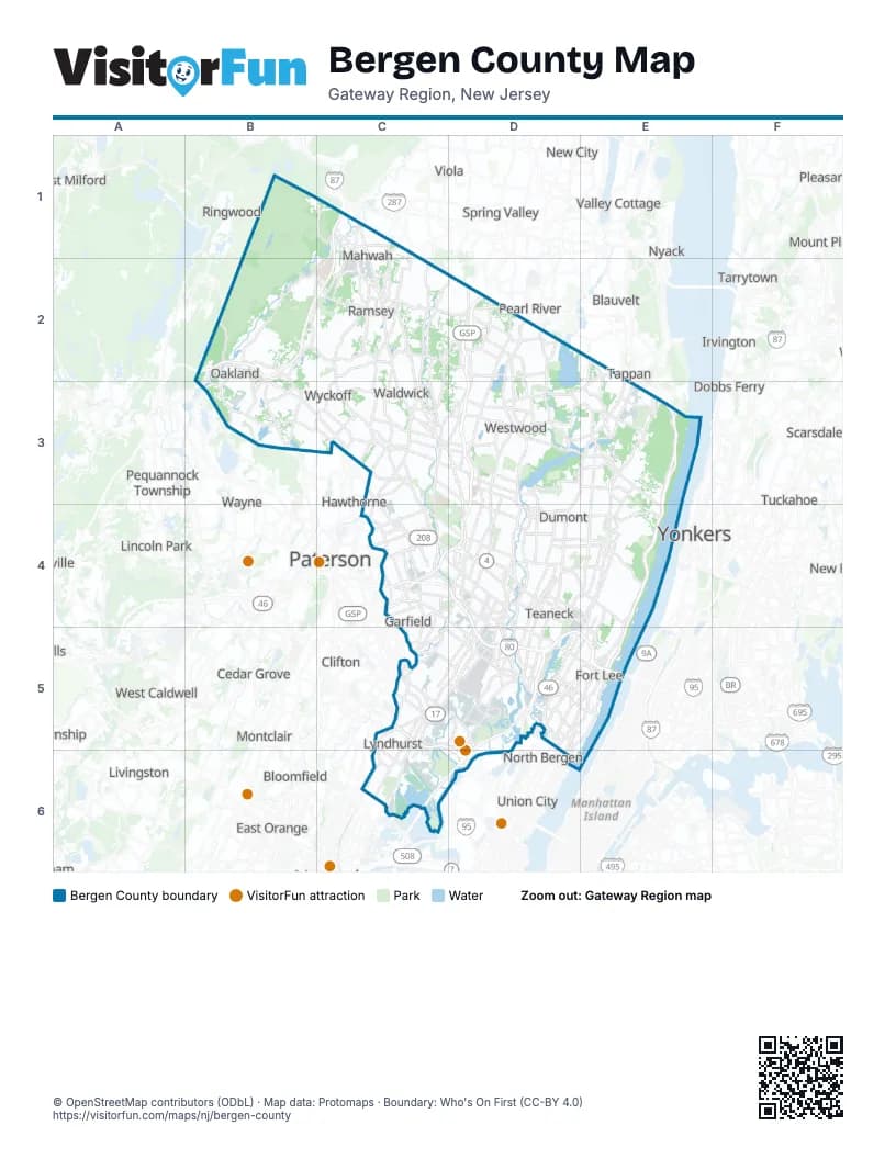
Street index of Bergen County
Each street on the sheet and the grid squares it crosses.
- Franklin TurnpikeC1, C2, C3
- Island RoadC1, C2
- Middlesex FreewayC1, B2, C2
- Orange AvenueC1
- Ramapo Valley RoadC1, B2, C2, B3
- Route 17 NorthC1, C2
- Route 17 SouthC1, C2
- Campgaw RoadB2, C2
- Colonial RoadB2
- Darlington AvenueB2, C2
- Darlington RoadB2
- Franklin AvenueB2, B3, C3
- High Mountain RoadB2, B3
- I 287NB2
- I 287SB2
- Pulis AvenueB2, C2
- Skyline DriveB2
- West Oakland AvenueB2, B3
- Brookside AvenueC2
- Chestnut Ridge RoadC2, D2, C3
- Crescent AvenueC2, C3
- East Allendale AvenueC2
- East Allendale RoadC2, D2
- East Crescent AvenueC2
- East Main StreetC2, D4, E4, D5
- East Saddle River RoadC2, D2, C3
- Forest AvenueC2, D3, D4
- Forest RoadC2
- Godwin AvenueC2, C3
- Hawthorne TerraceC2
- Hillside AvenueC2, E4
- Lake StreetC2, D2
- MacArthur BoulevardC2
- Mountainview RoadC2
- North Central AvenueC2
- North Franklin TurnpikeC2, C3
- Park AvenueC2, E5
- West Crescent AvenueC2
- West Main StreetC2, D4, D5
- West Orchard StreetC2
- West Saddle River RoadC2, C3
- Woodcliff Lake RoadC2, D2
- Wyckoff AvenueC2, C3
- Blue Hill RoadD2
- Blue Hill Road SouthD2
- BroadwayD2, D3, C4
- County RoadD2, E3, E4
- Garden State ParkwayD2, D3, C4, D4
- Glen RoadD2, D5, E5
- Grand Avenue EastD2
- Grand Avenue WestD2
- Kinderkamack RoadD2, D3, D4
- North Kinderkamack RoadD2
- Orangeburgh RoadD2, E2
- Park StreetD2
- Prospect AvenueD2
- Railroad AvenueD2, D5
- Rivervale RoadD2, D3
- Saddle River RoadD2, C3, C4
- South Kinderkamack RoadD2
- South Middletown RoadD2
- Werimus RoadD2, D3
- West Grand AvenueD2
- Woodcliff AvenueD2
- Dewolf RoadE2, E3
- Old Tappan RoadE2, D3, E3
- Breakneck RoadB3
- Colfax AvenueB3
- Ewing AvenueB3
- Franklin Lake RoadB3
- Long Hill RoadB3
- Plaza RoadB3
- Post RoadB3
- Russell AvenueB3, C3
- Sicomac AvenueB3, C3
- Summit AvenueB3
- Cedarhill AvenueC3
- East Prospect StreetC3
- East Ridgewood AvenueC3, D3
- Elm AvenueC3
- Garber SquareC3
- Goffle Hill RoadC3
- Goffle RoadC3
- Harristown RoadC3
- Hollywood AvenueC3
- Jacquelin AvenueC3
- Lake AvenueC3
- Lincoln AvenueC3, C4
- Linwood AvenueC3, E5
- Linwood Avenue EastC3, D3
- Linwood Avenue WestC3
- Maple AvenueC3, C4
- Monroe StreetC3, C5
- North Maple AvenueC3
- North Monroe StreetC3
- Paramus RoadC3, C4
- Prospect StreetC3
- Sheridan AvenueC3
- South Maple AvenueC3
- South Monroe StreetC3
- Van Emburgh AvenueC3, D3
- Wearimus RoadC3, D3
- Wilsey SquareC3
- 3rd AvenueD3
- 4th AvenueD3
- Cripplebush RoadD3, E3
- East Firehouse LaneD3
- From RoadD3
- Highland AvenueD3
- Lafayette AvenueD3
- Lake DriveD3
- Old Hook RoadD3, E3
- Old Tappan DriveD3
- Oradell AvenueD3
- Pascack RoadD3
- Piermont AvenueD3
- Ridgewood AvenueD3
- Ridgewood RoadD3
- Washington AvenueD3, E3, D4, D5
- Washington Avenue SouthD3
- Westwood AvenueD3
- Zabriskie PlaceD3
- Alpine Approach RoadE3
- Anderson AvenueE3, D5, E5
- Blanch AvenueE3
- Closter Dock RoadE3, E4
- High StreetE3
- Knickerbocker RoadE3, E4
- Lafayette RoadE3
- Livingston StreetE3
- Palisades BoulevardE3, E4
- Palisades Interstate ParkwayE3, E4, E5
- Piermont RoadE3, E4
- Schraalenburgh RoadE3
- Century RoadC4
- Christopher Columbus HighwayC4, D4, D5
- East 33rd StreetC4
- Fair Lawn AvenueC4
- Locust StreetC4
- Main StreetC4, D4, C5, D5, E5
- Market StreetC4, D4
- Morlot AvenueC4
- NJ 4C4
- Red Mill RoadC4
- River DriveC4, C5
- River RoadC4, D4, D5, E5, C6, D6
- South Paramus RoadC4
- US Highway 46C4
- Wagaraw RoadC4
- West Century RoadC4, D4
- West Passaic StreetC4, D4
- Anderson StreetD4
- Bergen Town Center DriveD4
- Bridge StreetD4
- Cedar LaneD4
- Court StreetD4
- East Anderson StreetD4
- East Century RoadD4
- East Madison AvenueD4, E4
- East Passaic StreetD4
- East Salem StreetD4
- Essex StreetD4, D5
- Grand AvenueD4, E4, D5, E5
- Hackensack AvenueD4
- Henley AvenueD4
- Jefferson StreetD4
- Johnson AvenueD4
- Liberty RoadD4, E4
- Madison AvenueD4, E4
- Madison StreetD4
- Maywood AvenueD4
- Midtown Bridge StreetD4
- N.J. State Route 17D4
- New Bridge RoadD4
- New Milford AvenueD4
- Newbridge RoadD4
- North Prospect AvenueD4
- North Washington AvenueD4
- Northumberland RoadD4
- Passaic StreetD4, C5
- Polifly RoadD4, D5
- ramp to Essex Street (to I-80 West)D4
- River Edge AvenueD4
- River Edge RoadD4
- River StreetD4, D5
- Riverview AvenueD4
- Roemer AvenueD4
- Salem StreetD4
- South River StreetD4, D5
- South Washington AvenueD4
- Teaneck RoadD4, D5
- Union StreetD4
- West Essex StreetD4
- West Fort Lee RoadD4, D5
- West Madison AvenueD4
- Camp Merritt Memorial CircleE4
- Dean DriveE4
- East Clinton AvenueE4
- East Hudson AvenueE4
- East Palisade AvenueE4
- Engle StreetE4
- Hudson TerraceE4, E5
- Huyler AvenueE4
- North Dean StreetE4
- Riveredge RoadE4
- South Dean StreetE4
- Sylvan AvenueE4, D5, E5
- Union AvenueE4, C5
- Van Nostrand AvenueE4
- Washington StreetE4
- West Palisade AvenueE4
- West Railroad AvenueE4
- Westervelt AvenueE4
- Carlton AvenueC5
- East Erie AvenueC5
- Enoch StreetC5
- Erie AvenueC5
- Hackensack StreetC5, D5
- Highland CrossC5
- Hoboken RoadC5
- Jackson AvenueC5
- Kingsland AvenueC5, C6
- Locust AvenueC5
- Locust LaneC5
- Main AvenueC5
- Main Street BypassC5
- Marginal RoadC5
- Meadow RoadC5
- Memorial DriveC5
- Midland AvenueC5
- Passaic AvenueC5, C6
- Paterson AvenueC5
- Paterson Plank RoadC5, D5
- Ridge RoadC5, C6
- Riverside AvenueC5, C6
- Rutherford AvenueC5
- Station Square RoundaboutC5
- West Erie AvenueC5
- 2nd StreetD5
- 5th StreetD5
- 6th StreetD5
- Bergen BoulevardD5, E5
- Bergen TurnpikeD5
- Bergenline AvenueD5
- Broad AvenueD5
- Central BoulevardD5, E5
- Challenger RoadD5
- Columbia AvenueD5
- Cypress AvenueD5
- Degraw AvenueD5
- East Central BoulevardD5
- East Columbia AvenueD5
- East Homestead AvenueD5
- East Kansas StreetD5
- East Kennedy StreetD5
- East Moonachie RoadD5
- East Winant AvenueD5
- Emerson StreetD5
- Empire BoulevardD5
- Fairview AvenueD5
- Fort Lee RoadD5, E5
- Glenwood AvenueD5
- Gorge RoadD5, D6
- Harding PlaceD5
- Hendricks CausewayD5
- Hudson StreetD5
- Kennedy StreetD5
- Larry Doby HighwayD5, D6
- Liberty StreetD5
- Longworth AvenueD5
- Moonachie AvenueD5
- Moonachie RoadD5
- Mount Vernon StreetD5
- New Jersey TurnpikeD5
- New Jersey Turnpike Eastern SpurD5
- New Jersey Turnpike Express RoadwayD5, E5
- New Jersey Turnpike Local RoadwayD5, E5
- New Jersey Turnpike Western SpurD5, C6, D6
- North AvenueD5
- Palisade AvenueD5, E5, D6
- South Broad AvenueD5
- Terminal LaneD5
- Terrace AvenueD5
- Tonnelle AvenueD5
- Vreeland AvenueD5
- West Central BoulevardD5
- West Columbia AvenueD5
- West Shore AvenueD5
- Winant AvenueD5
- Bridge Plaza NorthE5
- Bridge Plaza SouthE5
- Bruce Reynolds BoulevardE5
- Caspars LaneE5
- Center AvenueE5
- Central RoadE5
- Country RoadE5
- Edwin AvenueE5
- Fletcher AvenueE5
- George Washington Bridge Lower LevelE5
- George Washington Bridge Upper LevelE5
- Kelby StreetE5
- Lemoine AvenueE5
- Mackay HighwayE5
- Maple StreetE5
- Schlosser StreetE5
- South Bridge PlazaE5
- State Route 5E5
- Belleville TurnpikeC6
- Kearny AvenueC6
- Schuyler AvenueC6
Things to do on the Bergen County map
Places on the map
- 1-E Landfill
- Allendale
- Allendale Wetlands
- Alpine
- Alpine Country Club
- Amazon Logistics (DJZ2)
- American Dream
- Arcola Country Club
- Artesian Fields County Park
- Avalon at Wesmont Station
- Avon Landfill
- Baker Pond
- BD Franklin Lakes Office
- Bear Swamp
- Bear Swamp Lake
- Bergen County
- Bergen Generating Station
- Bergenfield
- Bogert Pond
- Bogota
- Borg's Woods
- Boulder Run Shopping Center
- Brookchester Apartment Homes
- Brookside Cemetery
- Bunker Pond
- Caille Lake
- Camp Glen Gray
- Camp Yaw Paw
- Campgaw Mountain Reservation
- Campgaw Mountain Ski Area
- Carlstadt
- Cat Swamp
- Celery Farm Natural Area
- Cliffside Park
- Closter
- Closter Plaza
- Courts at Glenpointe
- Cresskill
- Crestwood Park
- Cristian Health - Ramapo Ridge Psychiatric Hospital
Next to Bergen County
- Airmont
- Blauvelt
- Bloomfield
- Briarcliff Manor
- Cedar Grove
- Clifton
- Dobbs Ferry
- East Orange
- Hawthorne
- Irvington
- Lincoln Park
- Livingston
- Monsey
- Montclair
- Mount Pleasant
- Mount Vernon
- New City
- New Square
- North Bergen
- Nyack
- Passaic
- Paterson
- Pearl River
- Pequannock Township
- Pleasantville
- Pompton Lakes
- Ringwood
- Scarsdale
- Sleepy Hollow
- Spring Valley
- Tappan
- Tarrytown
- Totowa
- Tuckahoe
- Union City
- Valley Cottage
- Viola
- Wanaque
- Wayne
- West Caldwell
- West Milford
- Yonkers
© OpenStreetMap contributors (ODbL) · Map data: Protomaps · Boundary: Who's On First (CC-BY 4.0)