

New Jersey map
Bridgeton map
About 27,722 people live here (Census Bureau, 2024 estimate). The sheet's index lists 264 streets; North Pearl Street, Markley Drive and Bank Street cross the most grid squares. Also on it: Bridgeton City Park, Bridgeton Senior High School and East Lake.
Open the map (PDF, US Letter)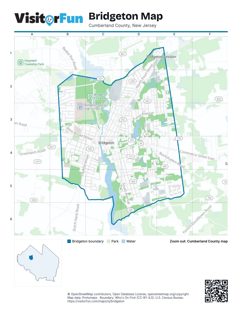
Street index of Bridgeton
Each street on the sheet and the grid squares it crosses.
- Bertini DriveD1
- Chestnut AvenueD1, C2, D2
- Dubois AvenueD1, D2
- Edward AvenueD1, D2
- Logan StreetD1, E1
- Mulford CourtD1, D2
- Mulford DriveD1, D2
- North Pearl StreetD1, E1, D2, C3, D3, C4
- Logan LaneE1
- Pearl Street NorthE1
- Beebe Run RoadB2
- Hitchner AvenueB2
- Mary Elmer DriveB2
- Mather AvenueB2
- North West AvenueB2, B3
- Northwest DriveB2
- Park Drive WestB2, C2
- Park LaneB2
- Smith AvenueB2
- Stave Mill RoadB2
- Thompson AvenueB2, B3
- Thompson CourtB2, B3
- Westwood AvenueB2, B3
- Woodcrest AvenueB2
- Charles StreetC2, D2
- Clark StreetC2, D2
- Falcon StreetC2
- Markley DriveC2, D2, C3, D3
- Mayor Aitken DriveC2, C3
- Mount Vernon StreetC2, C3
- Nichols StreetC2, C3
- North Laurel StreetC2, D2, C3
- Penn StreetC2, D2
- American AvenueD2
- Bank StreetD2, C3, D3, C4
- Bridgeton AvenueD2
- Cedarbrook AvenueD2, E2, E3
- Coral AvenueD2, D3, D4
- Cumberland AvenueD2
- Halford AvenueD2
- Harrison StreetD2, D3
- High StreetD2
- Highland AvenueD2
- Hill StreetD2
- Horton StreetD2
- Indian AvenueD2, E2
- Kings WayD2
- Madison StreetD2
- Magnolia AvenueD2, D3
- Manheim AvenueD2, D3, D4
- Monroe StreetD2
- Morton StreetD2
- Railroad AvenueD2, D3
- Ridge AvenueD2
- Rosenhayn AvenueD2, E2
- Spring StreetD2, D3
- Ewing StreetE2, E3
- Fern RoadE2
- Hilltop DriveE2
- Liberty RoadE2
- North Burlington RoadE2, E3, E4
- Rogers AvenueE2, E3
- Victory CourtE2
- Victory RoadE2
- Albertson AvenueB3
- Budd StreetB3
- Burt StreetB3, C3
- Central AvenueB3
- Cinderella DriveB3
- Frazier AvenueB3
- Hopewell RoadB3
- Kirby AvenueB3
- Lake StreetB3, C3
- Marlyn StreetB3
- North Lawrence StreetB3
- Oak StreetB3, C3, C4
- Preston AvenueB3
- Scholastic DriveB3, C3
- Sherman StreetB3
- Shiloh PikeB3
- South Lawrence StreetB3, B4
- South West AvenueB3, B4
- Vickers AvenueB3
- Violet DriveB3
- Watson AvenueB3
- West Broad StreetB3, C4
- West Commerce StreetB3, C3
- Atlantic StreetC3, C4, B5, C5
- Babe Ruth DriveC3
- Cedar StreetC3, D3
- Church LaneC3
- Cohansey StreetC3
- Commerce Street EastC3, C4, D4, E4
- Egret StreetC3
- Elmer StreetC3, D3
- Franklin DriveC3
- Franklin StreetC3, C4
- Irving AvenueC3, D3, E3
- Lanning StreetC3
- Marion StreetC3, D3
- Myrtle StreetC3, D3
- North Giles StreetC3
- North StreetC3, D3
- Park Access RoadC3
- Rose StreetC3
- Sharp StreetC3
- South Giles StreetC3, B4, C4
- South Laurel StreetC3, C4
- Union StreetC3
- Walnut StreetC3, D3, C4
- Washington StreetC3
- Casarow DriveD3, E3
- Church StreetD3, D4
- Cocelli DriveD3, E3
- Dare AvenueD3, D4
- Dare StreetD3
- East AvenueD3, D4
- East Myrtle StreetD3
- East Orchard StreetD3, E3
- Hobson StreetD3
- Holly StreetD3
- James PlaceD3
- Lakeview AvenueD3
- Linden StreetD3
- Nixon AvenueD3
- North Elm StreetD3, D4
- Orchard StreetD3, E3
- Parker StreetD3
- Seibel StreetD3
- Station Hill RoadD3
- Twin Oaks DriveD3, E3, E4
- West Orchard StreetD3
- Wood StreetD3
- York StreetD3
- Beck DriveE3
- Brookside DriveE3
- Caselli CourtE3
- Crestwood DriveE3
- Timber RoadE3
- Academy StreetB4, C4
- Belmont AvenueB4, C4, C5
- Bergen StreetB4
- Bowentown RoadB4
- Columbus AvenueB4
- Cottage AvenueB4, C4
- Devonshire PlaceB4
- Fayette StreetB4, C4, B5
- Giles RoadB4
- Glen DriveB4
- Glenview TerraceB4
- Hampton StreetB4, C4
- Lincoln StreetB4, C4
- Lincoln WayB4, C4
- Mead AvenueB4
- New StreetB4, C4
- North DriveB4, C4
- Overlook DriveB4
- Powell LaneB4
- Quarter Mile LaneB4
- Rugby LaneB4
- South DriveB4, C4
- South Quarter Mile LaneB4
- Suncrest AvenueB4
- Villa LaneB4
- Vine StreetB4, C4
- Wayne RoadB4
- Eagle StreetC4
- East Broad StreetC4, D4
- East Commerce StreetC4, D4
- Glass StreetC4
- Grove StreetC4, C5, D5, D6
- Henry StreetC4, D4
- Institute PlaceC4
- McCormick PlaceC4
- Mill StreetC4, D4
- Orange StreetC4
- Oxford StreetC4, C5
- Pine StreetC4
- River StreetC4
- Riverwalk SouthC4
- South AvenueC4, C5, D5, D6
- South Pearl StreetC4
- South Pine StreetC4, D4, D5
- State StreetC4
- Taylor StreetC4
- Warren StreetC4
- Water StreetC4, C5
- Willow StreetC4, D4
- Woodland DriveC4
- Birch StreetD4
- Bryn Mawr AvenueD4
- Buckshutem RoadD4, E4
- Cherry StreetD4
- Division StreetD4
- Edgewood AvenueD4
- Ellis StreetD4
- Florida AvenueD4
- Gary StreetD4, D5
- Gilmore StreetD4, E4
- Green AvenueD4, D5
- Jordan AvenueD4, E4
- Lewis AvenueD4
- Maple DriveD4
- North Spruce StreetD4
- Parker LaneD4
- Price StreetD4, E4
- Ramblewood DriveD4
- Richardson AvenueD4, D5
- South East AvenueD4, D5, D6
- South Elm StreetD4
- Spruce StreetD4, D5
- Stephenson AvenueD4, D5
- Strawberry StreetD4
- Terrace StreetD4
- Burlington ManorE4, E5
- Cohansey River Shore AvenueE4
- Fairview AvenueE4
- Haynes AvenueE4
- Park AvenueE4
- Pleasant AvenueE4
- Reeves RoadE4
- South Burlington RoadE4, E5
- Sunrise LaneE4
- Wells LaneE4
- Cubby Hollow RoadB5
- Dutch Neck RoadB5
- Harvard AvenueB5, C5
- Princeton AvenueB5, C5
- Rutgers AvenueB5, C5
- Summit AvenueB5, C5
- University AvenueB5, C5
- Baltimore AvenueC5, D5
- Cambridge AvenueC5
- Cedar Dell AvenueC5, D5
- Cornell AvenueC5
- Fremont AvenueC5, D5
- Garfield AvenueC5, D5
- Morris AvenueC5, D5
- Purdue AvenueC5
- Russell Sage AvenueC5
- Colfax StreetD5
- Cone StreetD5
- Garden AvenueD5
- Garden RoadD5
- Gilbert AvenueD5, E5
- Independence LaneD5
- Kersey StreetD5, E5
- Lambdin AvenueD5
- Manson AvenueD5
- North Industrial BoulevardD5, E5
- Pamphylia AvenueD5, E5
- Pine Street SouthD5
- Russell AvenueD5
- Sharp AvenueD5
- South Industrial BoulevardD5, E5
- Theorosa RoadD5
- Therosa RoadD5
- West Industrial BoulevardD5
- Wiley StreetD5
- Andrews AvenueE5
- Gardner AvenueE5
- Marshall AvenueE5
- Clarks Pond RoadD6
- WMA Access RoadD6
Places on the map
- 7-Eleven
- Aqui Market
- Bark in the Park
- Bridgeton Christian School
- Bridgeton City Hall
- Bridgeton City Park
- Bridgeton Middle School
- Bridgeton Senior High School
- Bridgeton Southern New Jersey All Sports Hall of Fame Museum
- Bridgeton State Office Building
- Broad Street Deli & Liquor
- C-Town
- Carrasco's
- Cohanzick Zoo
- Cumberland College Steamworks
- Dollar General Market
- Dollar Tree
- East Lake
- Exit Clean Car Wash
- High Point Park
- Inspira Health Center Bridgeton
- James Giles House
- Jeddy's Pond
- Jeremiah Buck House
- London Liquor Discount
- McDonald's
- Ocean First Bank
- Old Broad Street Presbyterian Church
- Quarter Mile Lane School
- Recreation Hill
- Saint Teresa of Avila Church
- Sinclair
- South Jersey Hospital System Heliport
- TD Bank
- The Church of Jesus Christ of Latter-day Saints
- Tortilleria El Paisano
- Trinity United Methodist Church
- United States Post Office
- Wawa
- West Avenue Elementary School
© OpenStreetMap contributors, Open Database License, openstreetmap.org/copyright · Map data: Protomaps · Boundary: Who's On First (CC-BY 4.0); U.S. Census Bureau















