

New Jersey map
Cumberland County map
About 155,678 people live here (Census Bureau, 2024 estimate). The sheet's index lists 300 streets; Church Street, Main Street and Cedar Street cross the most grid squares. Things to do inside the boundary: Cumberland Mall, Millville Army Air Field Museum and WheatonArts.
Open the map (PDF, US Letter)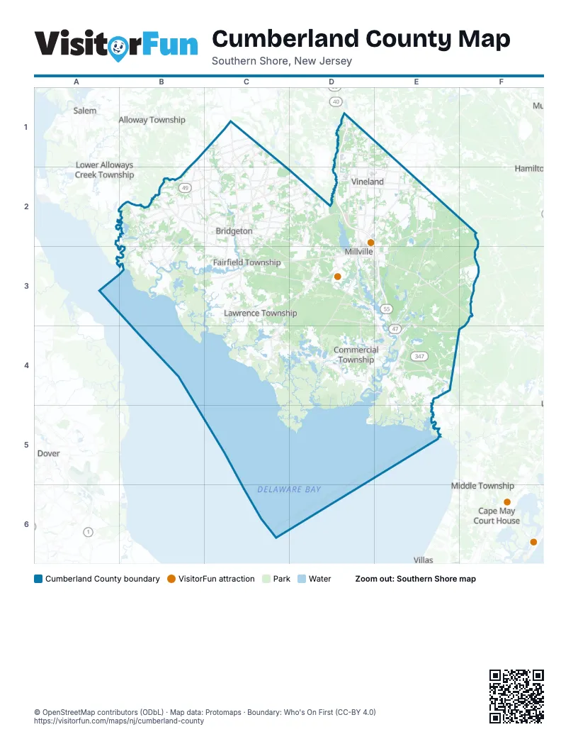
Maps inside Cumberland County
3 maps inside, from the street map of Cumberland County down.
Street index of Cumberland County
Each street on the sheet and the grid squares it crosses.
- Veterans Memorial HighwayD1, D2, E3
- Main StreetB2, C3, C4, D4, E4
- Landis AvenueC2, D2, E2
- East Main StreetD3, E3, F3
- Delsea DriveE3, E4, E5
- New Stage RoadE4
- South Lincoln AvenueD2, E2
- West Main StreetD2, D3
- North Delsea DriveD1, D2, E4
- South Main RoadD2, E2
- South 2nd StreetD2, D3, E3
- Centerton RoadC1, C2
- South Delsea DriveD2
- Columbia HighwayB2, C2
- Mays Landing RoadE2
- Shiloh PikeB2, C2
- North 2nd StreetD2, D3
- Finley RoadC2
- East Broad StreetC2, D3, E3
- South Woodruff RoadC2
- Bridgeton Millville PikeC2, D2
- North Pearl StreetC2, D3
- Millville-Mays Landing RoadE2, F2
- North Main RoadE1, E2
- Commerce Street EastC2
- North 3rd StreetD2, D3
- Quinton-Marlboro RoadB2
- East Mays Landing RoadE2, E3
- Wheaton AvenueD2, D3
- West Broad StreetC2, D3
- South 2nd Street / Delsea DriveE3
- East Finley RoadC2
- Gouldtown-Woodruff RoadC2
- Gouldtow-Woodruff RoadC2
- Burns AvenueD2
- North Lincoln AvenueE2
- Pearl Street NorthC2
- Hennis RoadD2
- Lincoln AvenueC2, D2, E2
- Broad StreetF2, E4
- Northwest StreetC2
- East Creek Mill RoadE4
- Cedarville RoadC3, D3
- Union RoadE2, E3
- West Buckshutem RoadD3
- Roadstown RoadB2, C2
- Irving AvenueC2, D2
- Sheppards Mill RoadB2, B3, C3
- Weatherby RoadE3, E4, F4
- Narrow Lane RoadD3, D4
- Fairton Millville RoadC3, D3
- Buckshutem RoadC2, C3, D3
- Port Elizabeth-Cumberland RoadE3, E4
- North West AvenueD1, C2, D2
- Morton AvenueD2
- Big Oak RoadC2, D2
- North AvenueC3, D4
- Leesburg Belleplain RoadE4
- South West BoulevardD2
- West Sherman AvenueD2
- Greenwich RoadB2, C2, B3
- East Sherman AvenueD2, E2
- Highland StreetD4, E4
- Maple AvenueB2, C2, E2, C3
- East Buckshutem RoadD3, E3, E4
- North West BoulevardD1, D2
- South East BoulevardD2
- North East BoulevardD1, D2
- Newport RoadC3, D3, C4
- Silver Run RoadD3
- Fairton RoadD3
- Fairton-Gouldtown RoadC2, C3
- Marlboro RoadB2
- Parvins Mill RoadC2, D2
- Willis RoadB2
- Old Burlington RoadC1, C2
- Deerfield RoadC1
- Shiloh-Cohansey RoadB1, B2
- Beebe Run RoadC2
- Cedar StreetD1, C2, D2, D3, E4
- West Garden RoadD1
- Ye Greate StreetB2, B3
- Dividing Creek RoadD3
- Church StreetC2, C3, D3, E3, D4, E4
- North Wade BoulevardD2, D3
- Haleyville RoadD4
- Minches Corner RoadC2
- Friesburg Deerfield RoadC1
- Mauricetown BypassD4, E4
- Causeway RoadB2
- Weymouth RoadD1
- South AvenueB2, C2, C3
- Almond RoadD2
- South West AvenueC2, D2
- Chestnut RoadB2
- West Deerfield RoadC1
- Nabb AvenueD2
- Bowentown RoadB2, C2
- Bridgeton RoadB2, B3
- North Brewster RoadE1, E2
- Grove StreetC2, C3
- Bridgeton Fairton RoadC3
- South Wade BoulevardD3, E3
- Mauricetown RoadE4
- East Park AvenueD2, E2
- County Road 540B1, C1
- Dutch Neck RoadC2, C3
- Beaver Dam RoadD4
- South Brewster RoadE1, E2
- West Park AvenueD2
- Central AvenueD1, C2, D3, E4
- G StreetD3
- Fayette StreetC2
- West RoadB2
- Sherman AvenueD2
- Orange StreetC2, D2, D3, E3
- West Weymouth RoadD1
- Burlington RoadC2
- Fairton Cedarville RoadC3
- Baptist RoadC4
- East Vine StreetD3
- Back RoadC4
- BroadwayD2, E2, E3
- West AvenueB2, D2
- Methodist RoadC4
- Greate StreetB3
- Wade BoulevardD2
- Fenimore StreetD2
- South Pearl StreetC2, D3
- North Brandriff AvenueD3
- South Race StreetD3
- South Brandriff AvenueD3
- East Weymouth RoadD1
- Mauricetown-Crossway RoadE4
- Beech StreetD3
- West Vine StreetD3
- Pecks Corner-Cohansey RoadB1
- West BoulevardD1
- Deerfield Friesburg RoadC1
- Centerton Husted Sta RoadC1
- Parvin Mill RoadD2
- Ackley RoadD3, E3, C4, D4
- Shaws Mill RoadC3, D3, C4
- Barretts Run RoadB2, C2, B3, C3
- Gum Tree Corner RoadB2, B3
- Ramah RoadC3, D3
- Back Neck RoadB3, C3
- Lebanon RoadC2, D2
- Hance Bridge RoadD2, E2, D3, E3
- Hesstown RoadE3, F3
- East Chestnut AvenueD2, E2
- Old Deerfield PikeC1, C2
- Spring Garden RoadD3, E3, D4
- Carmel RoadC2, D2, D3
- Hands Mill RoadE4, E5
- East AvenueB2, C2, C3
- Stow Creek RoadB2
- Fortescue RoadC4
- New Panther RoadE2
- South East AvenueC2, D2, C3
- Clarks Pond RoadC3
- Hogbin RoadD3
- Newport Neck RoadC4
- Bridgeton AvenueC2, D2, C4
- Estell Manor RoadE3, F3
- Trench RoadB2, C2, C3
- East Oak RoadD2, E2
- Jericho RoadB2
- Stathems Neck RoadB2, B3
- Harmony RoadB1, C1, B2, C2
- Kenyon AvenueD2
- Silver Lake RoadC2
- South Burlington RoadC2, C3
- Sayres Neck RoadC3
- Rosenhayn AvenueC2
- Vineland AvenueC2, D2
- High StreetC2, D4, E4
- Turkey Point RoadD4
- Center RoadC1
- James Moore RoadD4
- Battle LaneD3
- Reeves RoadC2, E4
- South Orchard RoadD2
- Richards RoadC2
- Macanippuck RoadB2
- Carlisle Place RoadE4
- Seeley Cohansey RoadC1, C2
- Woodruff RoadC1, C2
- Jones Island RoadC3, C4
- West Oak RoadD1, D2
- Sheppard Davis RoadC3
- Rockville RoadC3
- Park Drive WestC2
- Polk LaneC1
- Wheaton Island RoadB2, B3
- Garton RoadC2
- Northville RoadC1
- Maurice River ParkwayD1, D2
- Buckhorn RoadB2
- West Chestnut AvenueD2
- Dragston RoadD4
- Tindall Island RoadB3
- Hospital RoadB2
- Steep Run RoadE3, D4, E4
- Seely RoadC1, C2
- Walters RoadB2, C2
- Shoemaker LaneC2, C3
- Springtown RoadB2, B3
- North High StreetD2, D3
- Mosslander RoadE4
- Sharp StreetC2, D2, D3
- Old Mill RoadB2, B3
- Glade RoadE4
- Rogers AvenueC2, D2, E2
- School House RoadB3, C4
- Morias AvenueD2, D3
- East Wheat RoadE1
- Bacons Neck RoadB3
- West Wheat RoadD1
- Sugarman AvenueD2
- North Orchard RoadD1, D2
- Cornwell DriveC2
- North Burlington RoadC2
- Noble StreetD3, D4, E4
- Husted Station RoadC1
- Weber RoadC1
- East Garden RoadD1, E1
- Husted Bateman RoadC3
- Rieck AvenueD3
- College DriveD2
- Park DriveC2, D2, B3, D3, E3
- Bowers Creek RoadC3
- Jesse Bridge RoadD2
- Shoemaker RoadB2, C2
- Matt's Landing RoadD4, E4
- North Laurel StreetC2, D3
- Station RoadC4, E4
- Randolph RoadB2
- Mary Elmer DriveC2
- Beals Mill RoadB1, C1
- Palatine Lake RoadC1
- Davis Mill RoadB2
- Newcombtown RoadD3, E3
- Stillman AvenueD2
- Diament RoadB2
- Mayor Aitken DriveC2
- Landing RoadC4
- Holding RoadC2
- Cumberland DriveC2
- Fordville RoadC2
- Hickman AvenueD4
- Leaming Mill RoadE3
- Atlantic StreetC2
- Roadstown-Greenwich RoadB2
- Old Beaver Dam RoadD4
- Greenman AvenueD2
- Moores Corners RoadB2
- Manheim AvenueC2
- Hall RoadE4
- Laurel Heights DriveC2
- Shiloh RoadB2
- Schooner Landing RoadE3
- Chestnut AvenueD1, C2, E2
- West Commerce StreetC2
- Foster RoadC2
- North Shiloh AvenueD2
- Pamphylia AvenueC2
- Parsonage RoadC2
- Ferry RoadD4, E4
- Money Island RoadC4
- Vine StreetC2
- Mulford AvenueC3, D3
- Woodruff Carmel RoadC2
- John Dare RoadC2
- North Parsonage RoadC1, C2
- Market LaneB3
- Ward AvenueC3, D3, E4
- Roadstown-Shiloh RoadB2
- East Commerce StreetC2
- Burlington ManorC2
- Indian AvenueC2
- Tuska RoadD2
- Penn StreetC2, D3
- Front StreetE4
- Salem AvenueD1
- Crest AvenueE3
- Cake RoadC1, C2
- Wheat RoadD1, E1
- West Maple AvenueC3
- Downe AvenueC4
- Pier RoadB3
- Mackeys LaneE4
- Hall StreetC4
- Olivet RoadC1
- County Road 744E4
- Quigley AvenueD2
- Tumbling Dam RoadC2
- Daretown-Bridgeton RoadC1
- Iron Bridge RoadC3
- New Beaver Dam RoadD2
Things to do on the Cumberland County map
Places on the map
- Arrowhead Lake
- Bayside State Prison
- Bayside Tract Preservation Site
- Bostwick Lake
- Bridgeton
- Bridgeton City Park
- Buckshutem Wildlife Management Area
- Carlls Corner
- Cedarville
- Cedarville Road Complex
- Centre Grove
- Clarks Pond
- Clarks Pond Wildlife Management Area
- Cohansey River Wildlife Management Area
- Commercial Township
- Commercial Township Wetland Restoration Site
- Cumberland County Fairgrounds
- Cumberland Mall
- Cumberland-Hesstown
- Davis Millpond
- Deerfield Street
- Deerfield Township
- Delaware Bay
- Delaware Bay Shore Preserve
- Delmont
- Dividing Creek
- Dix Wildlife Management Area
- Dorchester
- Egg Island Wildlife Management Area
- Gandy's Beach Preserve
- Glades Wildlife Refuge
- Heislerville Wildlife Management Area
- Lummis Pond Preserve
- Manumuskin River Preserve
- Maurice River Bluffs Preserve
- Menantico Creek Preserve
- Millville Wildlife Management Area
- New Sweden Wildlife Management Area
- Peaslee Wildlife Management Area
- Union Lake Wildlife Management Area
Next to Cumberland County
- Alloway Township
- Cape May Court House
- Dover map
- Lower Alloways Creek Township
- Middle Township map
- Salem
- Villas
© OpenStreetMap contributors, Open Database License, openstreetmap.org/copyright · Map data: Protomaps · Boundary: Who's On First (CC-BY 4.0)















