

New Jersey map
Southern Shore map
The sheet's index lists 12 highways; NJ 47, US 9 and NJ 49 cross the most grid squares. Things to do inside the boundary: Aqua Action Watersports, Atlantic Parasail and Bayview Watersports Marina. Also on it: Bridgeton, Cape May and Commercial Township.
Open the map (PDF, US Letter)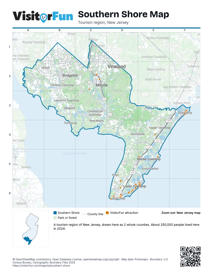
Highway index of Southern Shore
Each highway on the sheet and the grid squares it crosses.
- US 9D5, D6, E3, E4, E5, F3
- NJ 47C1, C2, C3, D3, D4, D5, D6, E4
- NJ 49A1, B2, C2, D2, D3, E3
- NJ 50E3, E4
- NJ 52F3
- NJ 55C1, C2, C3
- NJ 56B2, C1
- NJ 77B1, B2
- NJ 83E4
- NJ 109D6
- NJ 147D5, E5, E6
- NJ 347D3, D4
Things to do on the Southern Shore map
- Bayview Watersports Marina
- Cape May County Park & Zoo
- Cape May Historic District
- Cape May Lighthouse
- Cape May Point Arts and Science Center
- Cape May Whale Watcher
- Cloak & Dagger Escape Rooms
- Cumberland Mall
- Harriet Tubman Museum
- Historic Cold Spring Village
- Johnson's Popcorn
- Maple's Bakeshop
- Millville Army Air Field Museum
- Miss Avalon Fishing Boat
- Morey's Piers
- MudHen Brewing Co.
- NAS Wildwood Aviation Museum
- OC Waterpark
- Ocean View Resort Campground
- OCNJ Watersports Aqua Park
- Pier 47 Marine
- Primo Hoagies
- Revolution Rail Co.
- Sal's Pizza
- Salt Marsh Safari
- The Bagel Depot
- The Beachy Tiki
- The Wildwoods
- The Yard
- Thunder Cat Dolphin Watch
- Totally Tubular Watersports
- WheatonArts
- Wildwood Golf Cart Rental and Sales
- Wildwood Rental Supply
- Wildwoods Boardwalk
Places on the map
- Bridgeton
- Cape May
- Commercial Township
- Dennisville
- Fairfield Township
- Fortescue
- Lawrence Township
- Lower Township
- Middle Township
- Millville
- Newport
- Ocean City
- Port Norris
- Shiloh
- Stone Harbor
- Upper Township
- Villas
- Vineland
Next to Southern Shore
© OpenStreetMap contributors, Open Database License, openstreetmap.org/copyright · Map data: Protomaps · Boundary: U.S. Census Bureau, Cartographic Boundary Files 2024