

New Jersey map
Galloway Township map
About 38,347 people live here (Census Bureau, 2024 estimate). The sheet's index lists 300 streets; Moss Mill Road, White Horse Pike and Leipzig Avenue cross the most grid squares. Things to do inside the boundary: Historic Smithville & Village Greene and Noyes Museum of Art.
Open the map (PDF, US Letter)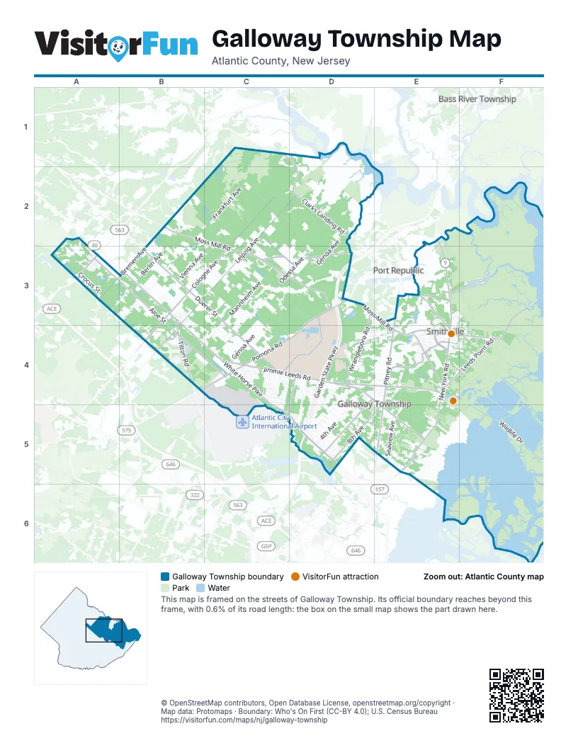
Street index of Galloway Township
Each street on the sheet and the grid squares it crosses.
- Garden State ParkwayD3, D4, D5
- White Horse PikeB3, B4, C4, C5, D5
- North New York RoadE2, E3, E4
- New York RoadE4, E5
- Tilton RoadB3, B4
- South New York RoadE4, E5
- East White Horse PikeD5
- Philadelphia AvenueA3
- Shore RoadE5
- Moss Mill RoadB2, C2, C3, D3, E3, E4, F4
- Jimmie Leeds RoadC4, D4, E4, E5
- Leipzig AvenueC2, D2, B3, C3, B4
- Pomona RoadD3, B4, C4, D4
- Pitney RoadE3, E4, E5
- Clarks Landing RoadC1, D1, D2
- Cologne-Port Republic RoadC3, D3
- Wrangleboro RoadD3, B4, D4
- Smithville BoulevardE4
- Old New York RoadE3, E4
- Pestalozzi AvenueC2, C3, D3
- Race Track RoadB4
- East Moss Mill RoadE4, F4
- South Pitney RoadE4
- Cologne AvenueC2, B3, C3, B4
- Aloe StreetA3, B3, B4, C4
- Duerer StreetB3, C3, C4
- Great Creek RoadD4, E4, F4
- Bremen AvenueB2, A3, B3
- Vera King Farris DriveD3, C4, D4
- 8th AvenueD5, E5
- 6th AvenueD4, D5
- Quail Hill BoulevardE4
- Leeds Point RoadE4, F4
- Old Port RoadE4
- East Motts Creek RoadE3, F3
- Oyster Creek RoadF3, F4
- Chris Gaupp DriveD4, C5
- South Quail Hill BoulevardE4
- Motts Creek RoadE3
- Wildlife DriveE4, F4, F5
- Mannheim AvenueD2, C3, D3, B4, C4
- Odessa AvenueD2, C3, D3, B4, C4
- Liebig StreetB2, C2, C3, D3
- Frankfurt AvenueB2, C2, B3
- Vienna AvenueC2, B3, C3
- Genoa AvenueD2, D3, C4
- Prague AvenueC2, D2, B3, C3, B4
- Ridgewood AvenueD4, D5, E5
- Herschel StreetC3, C4
- Indian Cabin RoadB2, C2
- Berlin AvenueB2, A3, B3
- 4th AvenueD4, D5
- Upland AvenueD4, D5, E5
- Zurich AvenueC3, D3, C4
- South 2nd AvenueD4, D5
- Ash AvenueD4, D5
- Country Club DriveB4
- Seaview AvenueE5
- Shiller StreetC2, D2
- Magnolia AvenueD5
- 1st AvenueD4, D5
- Galloway RoadE4
- East Brook LaneE5
- Fairway LaneE5
- Crocus StreetA3
- Nectar AvenueC4, D4, C5
- Kings HighwayE3
- Oakborne AvenueD5
- Spruce AvenueC4, C5
- Vine AvenueC4
- New Orleans AvenueA3
- Belladonna StreetA3
- East Smith Bowen RoadE3, F3, F4
- Willow AvenueC4
- County BoulevardA3
- South Genoa AvenueC3
- Sylvan AvenueE4
- Poplar AvenueC4, C5
- Xanthus AvenueC4
- East Ocean AvenueE5
- Upas AvenueC4
- Bally Bunlon DriveB4
- Fir AvenueD4, D5
- Orange Tree AvenueC4, C5
- Mattix RunD4
- North Quail Hill BoulevardE3, F3, E4
- Redwood AvenueC4, C5
- Arbutus AvenueD5
- East Brown AvenueE5
- Club PlaceD4
- Cape May AvenueA3
- Walden WayD4
- Smith Bowen RoadF4
- Colonial CourtD4, E4
- Quince AvenueC4, C5
- Holly AvenueD4, D5
- Highlands AvenueE4, E5
- Dennis DriveE4
- East Cos Cob DriveE4
- Somerstown LaneE5, F5
- Crestview AvenueD5
- Constitution DriveE4
- East Collins RoadD4, E4
- Ebony Tree AvenueD4, D5
- Holly Brook RoadE5
- Southampton DriveE4
- Lily Lake RoadE4, F4
- Pine StreetB3, D5
- Damson AvenueD5
- Kensington DriveE3, F3
- Mattix Run RoadD4
- Shaffer AvenueA3
- Pittsburg AvenueA3
- West Hayes AvenueC4
- Filmore AvenueC4, D4
- Buchanan AvenueC4, D4
- East Mourning Dove WayD4
- 10th AvenueD5, E5
- Louisville AvenueD4
- Pembrooke WayE4
- Yam AvenueC4
- East Biscayne AvenueE5
- Cleveland AvenueA3
- Scotts Landing RoadF4
- Chatham WayE4
- Delaware AvenueD4
- Boston AvenueA3
- Johnson AvenueC4, C5, D5
- Somers Landing RoadE4, E5
- East Forestbrook DriveE5
- Federal RoadD4
- Garfield AvenueC4, D4
- Zenia AvenueC4
- Frankford AvenueB3
- Tulip AvenueC4, C5
- East Lost Pine Way RoadE5
- Father Keis DriveC4
- Key DriveD4, E4
- Society Hill DriveD4, E4
- Terry LaneC4
- Seaview Ridge DriveE5
- Lakeside LaneD4
- Ravenwood DriveE4, F4
- Elm AvenueD5, E5
- Pineview DriveE5
- Liverpool AvenueA3
- East Pennsylvania AvenueE5
- Sussex PlaceE4
- School LaneB3
- Revere WayE4
- Atlantic AvenueA3, C4
- West McKinley AvenueC5, D5
- Beech AvenueD4, D5
- South Reeds RoadD4
- East Bartlett AvenueE5
- Greenwich DriveE4
- Oak Pond DriveD3
- Spencer LaneE4
- Brewster DriveE4
- Concord TerraceD4
- Town Center DriveE4
- Lake Front CircleE4
- Oak StreetB3
- Cypress Point DriveB4
- Lenape RoadD3
- Coventry WayE4
- Elton LaneC4
- English Creek RoadC4
- Curran CourtF4
- East Chanese LaneE5
- Harlequin DriveE4
- West St Joseph AvenueC4
- Avenue AC4
- Meadow Ridge RoadE4
- Gull Pond RoadF4
- Roosevelt AvenueA2, A3
- Dahlia StreetA3
- Laurel AvenueD4
- Birch StreetB3
- West Donna DriveC4
- Doughty RoadE4
- Liberty CourtD4
- Derby DriveE4
- Meadows DriveC4
- Henderson AvenueA3
- Adams AvenueC4, D4
- East Fishers Creek RoadE4
- South Schooner Landing RoadF4
- Cherokee DriveD4, E4
- Cincinnati AvenueA3
- 7th AvenueD5
- East Waveland AvenueD5
- Camelback DriveD4
- Limerick PlaceD3, E3
- Iroquois DriveD4
- Seminole DriveD4
- Forest Park DriveE4, F4
- Berrywood LaneF4
- Carlisle LaneE4
- Charles DriveD5
- Lindbergh AvenueE2, E3
- Patriots CourtD4
- East Stoney Hill RoadF4
- East Belmar AvenueE5
- Brampton StreetD3, D4
- Athletes DriveD4
- South Genista AvenueD5
- Wintergreen CourtF4
- Cresson AvenueD5, E5
- East Dickinson AvenueE5
- Spring Mill DriveD5
- Crowndale PlaceD3, E3, D4, E4
- Oxford CourtE4
- Donegal LaneD4
- Gatehouse DriveE4
- St George's DriveE4
- Rosemarie AvenueC4
- Robin LaneB3
- Pelham DriveE3
- 5th AvenueD5
- Langley AvenueC4
- Old Shore RoadE5
- Moonraker CourtE3, F3, F4
- Federal CourtD4
- Coolidge AvenueC4, D4
- South Bella CourtD4
- Clubhouse circleB4
- North Cavesson DriveE3, E4
- East Navesink DriveD4
- Jefferson AvenueA3, E5
- Maria Loretta LaneC4
- Stonewall DriveE4
- Pershington AvenueA3
- Tamara DriveE5
- Collins RoadE4
- Donna DriveC4
- Redwood Avenue SouthC4
- Deer Run WayE3
- Waterview DriveE4
- Blackburn StreetD3
- Cardinal WayE4
- Raven's Nest DriveE4
- Cheltenham AvenueD5
- East Grist Mill WayE4, F4
- Chancery LaneE4
- Jersey Woods DriveE4
- Trotters LaneE4
- Genista AvenueD4
- Thoreau TerraceD4
- Sharswood AvenueE5
- Brads CourtD5
- Weston DriveE4
- Cheshire DriveE4
- South Canary WayD4
- Theresa CourtD5
- Edgewater DriveE4
- Club House CourtB4
- East Glory RoadE3
- Lincoln AvenueA3
- Giulia LaneD4
- Salem WayE4
- East Cordery AvenueE5
- Michael AvenueD4, D5
- Hay RoadD1
- Polk AvenueD5
- Shawnee PlaceD4
- Wordsworth StreetE3, E4
- East McDevitt DriveE5
- Northampton RoadE4
- Tess Conover WayD5
- Grube AvenueB3
- Carton AvenueB3, B4
- Geneva StreetB3
- Edwards AvenueB3, B4
- Koch AvenueC4
- Manchester StreetE4
- West Pestalozzi AvenueC2
- Summerwood PlaceE5
- High School DriveD4
- Parker AvenueB3
- East Nightingale WayD4
- Fair Haven Hill CourtD4
- Warwick RoadE4
- Deer Creek DriveE4
- Jackson AvenueB3
- Apple DriveC4
- Regency DriveE4
- Cornwall DriveE4
- East Upland AvenueD4
- East Village DriveE5
- Galley CourtD3
- Gull Wing CourtE4, F4
- West Emerick AvenueC4
- Apache CourtE4
- Falcon Crest CourtE4, F4
- Rene AvenueA3
- Newcastle CourtE4
- Stepping Stone LaneF4
- Village DriveE5
- 3rd AvenueD5
Things to do on the Galloway Township map
Places on the map
- Absecon Highlands
- Absecon Wildlife Management Area
- Absegami High School
- Atlantic City Reservoir
- Baseball and Softball Fields
- Blue Heron Pines Golf Club
- Brigantine Wilderness
- Cologne
- Danzenbaker Pool
- Dog Island
- Edwin B. Forsythe National Wildlife Refuge
- Egg Island
- Elder Island
- Frank Sinatra Service Area
- Galloway National Golf Club
- Germania
- Historic Smithville
- Horseshoe Island
- Intramural Fields
- Lake Fred
- Leeds Point
- Lily Lake
- Little Egg Inlet
- Moss Mill Lake
- Nantucket at Galloway
- Nucleus
- Oceanville
- Patriot Lake Park
- Pickerel Pond
- Pomona
- Pomona Golf Club
- Renault Winery
- Salt Island
- Seaview Golf Club Bay Course
- Seaview Golf Club Pines Course
- Shady Pines
- Smithville
- Stockton University
- Vogt Pool North
- Vogt Pool South
Next to Galloway Township
- Bass River Township
- Port Republic
© OpenStreetMap contributors, Open Database License, openstreetmap.org/copyright · Map data: Protomaps · Boundary: Who's On First (CC-BY 4.0); U.S. Census Bureau















