

New Jersey map
Highland Park map
About 15,386 people live here (Census Bureau, 2024 estimate). The sheet's index lists 133 streets; Lincoln Avenue, Raritan Avenue and River Road cross the most grid squares. Also on it: Johnson Park, Rutgers Ecological Preserve and Donaldson Park.
Open the map (PDF, US Letter)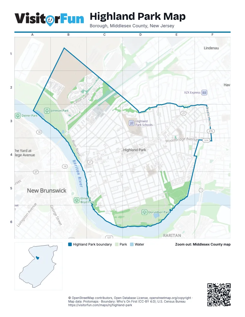
Street index of Highland Park
Each street on the sheet and the grid squares it crosses.
- River RoadA2, B2, B3, B4
- Cedar LaneB2, C2, B3
- Forest Glen DriveB2
- Holly CourtB2, C2
- Maple CourtB2
- Treetops DriveB2, C2
- Walnut CourtB2, C2
- Bartle CourtC2
- Edgemount RoadC2
- Harrison AvenueC2, B3, C3, B4
- Lincoln AvenueD2, C3, D3, B4, C4
- North 5th AvenueD2, D3, D4
- Perry RoadD2
- Johnson DriveA3, B3
- Cleveland AvenueB3, C3, B4
- Ella LaneB3
- Ethan LaneB3
- Gabriel LaneB3
- Greenland SquareB3, C3
- Hudson CircleB3
- Jackson AvenueB3, C3
- Kiersten DriveB3
- L'Ambiance CourtB3
- Leia LaneB3
- Mia DriveB3
- North 2nd AvenueB3, C3, C4
- Shep DriveB3
- Wayside RoadB3
- Brookdale CourtC3, D3
- Dickson CourtC3
- Grant AvenueC3, B4, C4
- Janeway AvenueC3
- Lawrence AvenueC3, B4, C4
- Madison AvenueC3, D3
- North 3rd AvenueC3, C4, D4
- North 4th AvenueC3, D3, D4
- Waksman LaneC3
- Wayne StreetC3, D3, C4
- Abbott StreetD3, E3
- Hamlin RoadD3
- Montgomery StreetD3, C4, D4
- North 6th AvenueD3, D4
- North 7th AvenueD3, D4
- North 8th AvenueD3
- North 9th AvenueD3, E3
- Raritan AvenueD3, E3, B4, C4, D4
- South Park AvenueD3, E3
- Amherst StreetE3, E4
- Archer PlaceE3
- Avon RoadE3, F3
- Barnard StreetE3, E4
- Brookhill AvenueE3
- Central AvenueE3, F3
- Cherry StreetE3, F3
- Columbia StreetE3, F3, E4
- Drier PlaceE3
- Harvard AvenueE3, F3
- Highland AvenueE3
- Lexington AvenueE3
- Lincoln HighwayE3
- Marlborough RoadE3
- McCallum PlaceE3
- Meriland AvenueE3, E4
- North 10th AvenueE3
- North 11th AvenueE3
- Parker RoadE3, F3
- Rolfe AvenueE3
- Seville AvenueE3, F3
- South 10th AvenueE3, E4
- South 11th AvenueE3, E4
- South 9th AvenueE3, E4, E5
- Washington AvenueE3
- Alcazar AvenueF3
- Blossom StreetF3
- Dartmouth StreetF3, F4
- Duclos LaneF3, F4
- Exeter StreetF3, F4
- Franklin StreetF3, F4
- Latonia StreetF3
- Rose StreetF3
- Sparkel AvenueF3
- Wisteria StreetF3
- Albany Street BridgeB4
- Penzias PlaceB4, C4
- Walter AvenueB4, C4
- Cedar AvenueC4, C5, C6
- Denison StreetC4, D4
- Magnolia StreetC4, D4, E4
- North Adelaide AvenueC4
- Park PlaceC4
- South 1st AvenueC4, C5, C6
- South 2nd AvenueC4, C5, D5, D6
- South Adelaide AvenueC4, C5, C6
- 6th AvenueD4, E4
- Benner StreetD4, E4, C5
- Felton AvenueD4, D5
- Grove AvenueD4, D5
- South 3rd AvenueD4, D5, D6
- South 4th AvenueD4, D5
- South 5th AvenueD4, D5, E5
- South 7th AvenueD4, E4, E5
- Summit PlaceD4, D5
- Woodbridge AvenueD4, E4, F4
- Aurora StreetE4
- Crowells RoadE4, F4, E5
- Eden AvenueE4, E5
- Hilton StreetE4
- Inza StreetE4
- Karsey StreetE4
- Labakan PlaceE4, F4
- Lewis StreetE4, F4
- Mansfield StreetE4, D5, E5
- South 8th AvenueE4, E5
- Volkert StreetE4
- Exeter AvenueF4
- Fox RoadF4, E5
- Cliff CourtC5
- Donaldson StreetC5, D5, E5
- Elbert CourtC5, C6
- Graham StreetC5, D5, E5
- Harper StreetC5, D5
- Hill StreetC5, D5
- Johnson StreetC5
- Muir WayC5
- Redcliffe AvenueC5
- Valley PlaceC5
- Becker StreetD5
- Braun AvenueD5
- Harper PlaceD5
- Park View TerraceD5
- Valentine StreetD5, E5, C6
- Riverview AvenueC6, D6
- Sullivan WayC6
Places on the map
- Acme Auto body
- Affordable Luxury Cars
- Anja
- Arch Auto
- Ayres Beach Natural Area (Red's Marina)
- B & B Auto Repair
- Ballfield 1
- Ballfield 2
- Ballfield 5
- Birnn Chocolate
- BLKBRN Dispensary
- Bridge Turkish & Mediterranean Grill
- Buck Woods
- Classic Cleaners
- Congregation Agudath Israel
- Congregation Ahavas Achim
- Congregation Etz Ahaim
- Congregation Ohav Emeth
- Cretans' Fraternity - The White Mountains
- Donaldson Dog Park
- Donaldson Park
- El Sol
- Ellinikon
- FBN Auto Sales
- First Baptist Church
- FreshMart
- Glatt 8
- Highland Park Borough Hall
- Highland Park Community Center
- Highland Park Conservative Temple
- Highland Park Farmer's Market
- Highland Park Good Earth Garden
- Highland Park Police Station
- Highland Park Post Office
- Highland Park Public Library
- Highland Park Schools
- Johnson Park
- Rutgers Ecological Preserve
- The Meadows
Next to Highland Park
- Lindenau
- New Brunswick map
- Raritan Gardens
- Rutgers Village
- The Yard at College Avenue
© OpenStreetMap contributors, Open Database License, openstreetmap.org/copyright · Map data: Protomaps · Boundary: Who's On First (CC-BY 4.0); U.S. Census Bureau















