

New Jersey map
Central Jersey map
The sheet's index lists 22 highways; I-95, US 1 and US 22 cross the most grid squares. Things to do inside the boundary: Bridgewater Commons, Brunswick Square and Central New Jersey. Also on it: Bedminster, Bernardsville and Bridgewater Township.
Open the map (PDF, US Letter)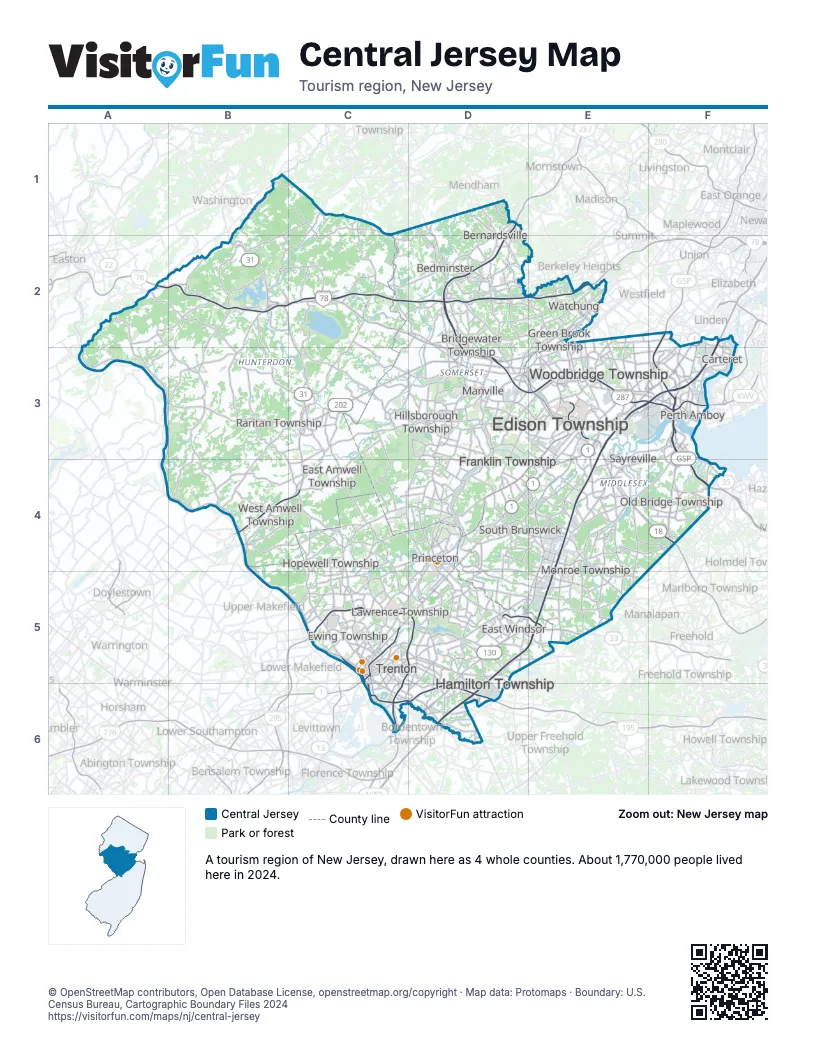
Highway index of Central Jersey
Each highway on the sheet and the grid squares it crosses.
- I-78A2, B2, C2, D2, E2
- I-95D5, D6, E3, E4, E5, F2, F3
- I-195C6, D6
- I-287D1, D2, D3, E3, F3
- I-295C5, C6, D5
- US 1C5, D4, D5, E3, E4, F2, F3
- US 9F2, F3, F4
- US 22A2, B2, C2, D2, D3, E2, E3
- US 130D5, D6, E3, E4, E5
- US 202B4, C3, C4, D2, D3
- US 206C5, C6, D1, D2, D3, D4, D5
- NJ 18E3, E4, F4
- NJ 29B4, B5, C5, C6
- NJ 31B2, C2, C3, C4, C5
- NJ 33D5, E5
- NJ 35F3, F4
- NJ 129C5, C6
- NJ 133D5, E5
- NJ 165B4
- NJ 173B2
- NJ 179B4, C4
- NJ 440E3, F3
Things to do on the Central Jersey map
- Bridgewater Commons
- Brunswick Square
- Central New Jersey
- Grounds For Sculpture
- Hageman Farm House
- Hunterdon Art Museum
- Metlar-Bodine House Museum
- Morven Museum & Garden
- New Jersey State Museum
- Old Barracks Museum
- Old Ryan Farm
- Princeton University
- Princeton University Art Museum
- Red Mill Museum Village
- Rutgers University Geology Museum
- Thomas Alva Edison Memorial Tower and Museum
- Ukrainian History and Education Center
- Van Liew-Suydam House
- Zimmerli Art Museum at Rutgers University
Places on the map
- Bedminster
- Bernardsville
- Bridgewater Township
- Carteret
- East Amwell Township
- East Windsor
- Edison Township
- Ewing Township
- Franklin Township
- Green Brook Township
- Hamilton Township
- Hillsborough Township
- Hopewell Township
- Lawrence Township
- Manville
- Monroe Township
- Old Bridge Township
- Perth Amboy
- Princeton
- Raritan Township
- Sayreville
- South Brunswick
- Trenton
- Watchung
- West Amwell Township
- Woodbridge Township
Next to Central Jersey
- Delaware River Region map
- Gateway Region map
- Shore Region map
- Skylands Region map
- Philadelphia and the Countryside
© OpenStreetMap contributors, Open Database License, openstreetmap.org/copyright · Map data: Protomaps · Boundary: U.S. Census Bureau, Cartographic Boundary Files 2024