

New Jersey map
New Brunswick map
About 57,487 people live here (Census Bureau, 2024 estimate). The sheet's index lists 298 streets; George Street, Memorial Parkway and Somerset Street cross the most grid squares. Things to do inside the boundary: Rutgers University Geology Museum, Somerset County and Zimmerli Art Museum at Rutgers University.
Open the map (PDF, US Letter)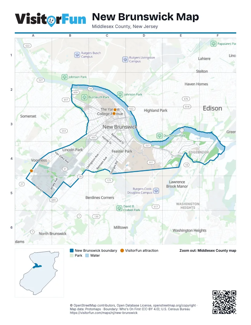
Street index of New Brunswick
Each street on the sheet and the grid squares it crosses.
- Buccleuch PlaceB2
- Delaware & Raritan Canal TowpathB2
- Easton AvenueB2, C2, C3
- George StreetB2, C2, C3, D4
- Huntington StreetB2, C2
- Jefferson AvenueB2, B3
- John A. Lynch Memorial BridgeB2, C2
- Landing LaneB2
- Lincoln PlaceB2
- New York AvenueB2
- Park BoulevardB2, B3
- Parkview DriveB2
- Bartlett StreetC2, C3
- Bishop PlaceC2
- College AvenueC2, C3
- Lafayette StreetC2
- Memorial ParkwayC2, C3, D3, D4
- Mine StreetC2, C3
- Morrell StreetC2, C3
- Ray StreetC2, C3
- Richardson StreetC2
- Seminary PlaceC2, C3
- Senior StreetC2
- Sicard StreetC2, C3
- Stone StreetC2, C3
- Wirt StreetC2
- Wyckoff StreetC2, C3
- Ambrose StreetB3
- Bridge StreetB3, C3
- Brookside AvenueB3, C3
- Central AvenueB3, C3
- Delafield StreetB3, C3
- Delavan StreetB3, C3, C4
- Duke StreetB3, C3
- Florence StreetB3, C3
- French StreetB3, C3
- Home StreetB3
- Kossuth StreetB3
- Laurel PlaceB3, C3
- Lorain StreetB3
- Main StreetB3
- Sandford StreetB3, C3, C4
- Somerset StreetB3, C3, A4, B4
- Woodbridge StreetB3, C3
- Abeel StreetC3, D3, D4
- Albany StreetC3, D3
- Alexander StreetC3
- Baldwin SteetC3
- Baldwin StreetC3, C4, D4
- Ball StreetC3
- Bayard StreetC3
- Bethany StreetC3
- Bristol StreetC3
- Carman StreetC3, D3
- Church StreetC3
- Cogswell PlaceC3
- Comstock StreetC3, C4
- Condict StreetC3
- Connector WayC3
- Courtlandt StreetC3
- Dennis AlleyC3
- Dennis StreetC3, D3
- Division StreetC3
- Dix StreetC3
- Drift StreetC3
- Elm RowC3
- Freeman StreetC3
- Guilden StreetC3
- Hale StreetC3, C4
- Hamilton StreetC3
- Handy StreetC3, C4, D4
- Hardenbergh StreetC3
- Hartwell StreetC3
- Harvey StreetC3
- Hassart StreetC3, D3
- High StreetC3
- Hildebrand WayC3, D3
- Hiram SquareC3, D3
- Hope Manor DriveC3
- James StreetC3
- Jersey AvenueC3, B4, A5, B5
- Johnson and JohnsonC3
- Johnson and Johnson PlazaC3
- Johnson DriveC3, D3
- Joyce Kilmer AvenueC3, B4, C4, B5
- Joyce Kilmer Avenue NorthC3
- Kirkpatrick StreetC3
- Lee AvenueC3, C4
- Liberty StreetC3
- Little Albany StreetC3
- Livingston AvenueC3, B4, C4, B5
- Louis StreetC3
- Maple StreetC3
- Monument SquareC3
- Morris StreetC3
- Neilson StreetC3, D3, D4
- New StreetC3
- Oak StreetC3
- Oxford StreetC3
- Paterson StreetC3
- Plum StreetC3
- Prospect StreetC3
- Prosper StreetC3
- Railroad AvenueC3, B4, C4
- Redmond StreetC3, C4, D4
- Remsen AvenueC3, C4
- Richmond StreetC3, D3
- Robinson StreetC3
- Scott StreetC3
- Seaman StreetC3, C4, D4
- Spring StreetC3
- Suydam StreetC3, C4, D4
- Tabernacle WayC3, D3
- Throop AvenueC3, D3, C4
- Townsend StreetC3, C4, D4
- Union StreetC3
- Wall StreetC3
- Washington StreetC3
- Welton StreetC3, C4
- Albany Street BridgeD3
- Bishop StreetD3, D4
- Burnet StreetD3, E4
- Elijah's WayD3
- John StreetD3
- Paul Robeson BoulevardD3, C4, D4
- Riverside DriveD3
- Route 18 Service RoadD3, D4
- Vorhees StreetD3, D4
- Donald Goodkind BridgeE3
- Hobart RoadE3, E4
- Manor CrescentE3, E4
- Morris Goodkind BridgeE3
- Player AvenueE3
- Regency Manor DriveE3, E4
- Wilcox RoadE3, E4
- New Jersey TurnpikeF3, F4
- Adams PlaceA4
- Camner AvenueA4
- Carter RoadA4, B4
- Class PlaceA4
- Edpas RoadA4, B4
- Hampton RoadA4, A5
- Henry AvenueA4
- Industrial DriveA4
- Jennings CourtA4, B4
- Oliver AvenueA4, B4
- Roosevelt AvenueA4
- Sample RoadA4, B4
- School AvenueA4
- Terminal RoadA4, A5
- Triangle RoadA4, B4, B5
- 4th StreetB4, B5
- 5th StreetB4, B5
- Bergen CourtB4
- Charles StreetB4
- Curtis PlaceB4
- Douglas AvenueB4
- Elizabeth StreetB4
- Ellen StreetB4, C4
- Gatling CourtB4
- Hay StreetB4
- Hollywood StreetB4
- Home News RowB4, A5
- Juliet StreetB4, C4
- Lake StreetB4
- Langley PlaceB4
- Loretta StreetB4, C4
- Lufberry AvenueB4
- May StreetB4, C4
- Mitchell AvenueB4
- Nassau StreetB4
- Pine StreetB4, C4
- Quentin AvenueB4
- Reed StreetB4
- Simplex AvenueB4
- South Dover AvenueB4
- Stevens StreetB4
- Tailer SquareB4
- Van Dyke AvenueB4
- Woodnor CourtB4, C4
- Wright PlaceB4
- Alder CourtC4
- Birch CourtC4
- Border AvenueC4
- Brush AvenueC4
- Cedar CourtC4
- Cliffe StreetC4
- Columbus PlaceC4
- Conger AvenueC4
- Dogwood CourtC4
- Edgeworth PlaceC4
- Evergreen DriveC4
- Fernwood CourtC4
- Fulton CourtC4
- Fulton StreetC4
- George's RoadC4
- Georges RoadC4
- Hazelhurst StreetC4
- Hickory DriveC4
- Howard StreetC4
- Jones AvenueC4, D4
- Kempton AvenueC4
- Larch AvenueC4
- Lawrence StreetC4
- Llewellyn PlaceC4
- Mason AvenueC4
- Nichol AvenueC4, D4
- North Talmadge StreetC4
- North Ward StreetC4
- Palmetto CourtC4
- Powers StreetC4
- Renaissance LaneC4
- Reservoir AvenueC4, D4
- Rutgers StreetC4
- South Talmadge StreetC4
- South Ward StreetC4
- Squibb DriveC4
- Starlight CourtC4
- Stratford PlaceC4
- Talmadge StreetC4
- Ward StreetC4
- Wellington PlaceC4
- Biel RoadD4
- Biel Road EastD4
- Biel Road WestD4
- Carpender RoadD4
- Chapel DriveD4
- Chemistry DriveD4
- Cobb RoadD4
- College Farm RoadD4
- Constitution SquareD4
- Cooper DriveD4
- Dewey DriveD4, E4
- Dudley RoadD4
- Gibbons CourtD4
- Hart AvenueD4
- Jessie PlaceD4
- Labor Center WayD4
- Lipman DriveD4
- Lyla LaneD4
- Newell AvenueD4
- Old Gibbons DriveD4
- Paulus Boulevard WestD4, E4
- Payton PlaceD4
- Phelps AvenueD4
- Raye AvenueD4
- Red Oak LaneD4
- Rutgers PlazaD4
- Ryders LaneD4
- Sadie CircleD4, E4
- State Route 18D4, E4
- Taylor DriveD4, E4
- Vermella DriveD4, E4
- Antile RoadE4
- Bowser RoadE4
- Chester CircleE4
- Clifton AvenueE4
- Cook RoadE4
- Cotter DriveE4
- Crest RoadE4
- Edgebrook RoadE4
- Goodale CircleE4
- Halstead RoadE4
- Hoffman BoulevardE4
- Lansing PlaceE4
- Longfield RoadE4
- Manor CourtE4
- Manor Crescent DriveE4
- North Pennington RoadE4, F4
- Paulus BoulevardE4
- Pennington RoadE4, F4
- South Pennington RoadE4, F4
- Stockton RoadE4, F4
- Tunison RoadE4, F4
- Tuthill RoadE4
- Voorhees RoadE4, F4
- Prentiss RoadF4
- Roberts RoadF4
- Astor StreetA5
- Delaware DriveA5
- How LaneA5
- Hudson DriveA5
- Iris StreetA5
- Janine PlaceA5
- Jules LaneA5
- Wabash DriveA5
- 12th StreetB5
- 6th StreetB5
- 7th StreetB5
- 8th StreetB5
- 9th StreetB5
- Bergen AvenueB5
- Beverly AvenueB5
- Cornell StreetB5
- Elmer PlaceB5
- Haverford StreetB5
- Hedges StreetB5
- Jerome PlaceB5
Things to do on the New Brunswick map
Places on the map
- Aja Asian Cuisine & Lounge
- ALDI
- Alice Jennings Archibald Park
- AMC New Brunswick 18
- Anshe Emeth Memorial Temple
- Antilles Field
- Archibald S. Alexander Library
- AutoZone
- Baker Park
- Bank of America
- Bayard Street Presbyterian Church
- Bettenbender Plaza
- Bishop Beach
- Boyd Park Amphitheatre
- Bravo
- Buccleuch Park
- Chabad House at Rutgers
- Chang Science Library
- Child Health Institute Of New Jersey
- Christ Church Graveyard
- Christ Episcopal Church
- Civic Square Building Plaza
- College Avenue Community Church
- Cook Rec Center Fields
- Deiner Park
- Elmer B Boyd Park
- Europastry
- Handy Street Post Office
- Hyatt Regency New Brunswick
- New Brunswick High School
- Pittman Park
- Queens Campus
- Recreation Park
- Rutgers College Avenue Campus
- Saint Peter's Cemetery
- Saint Peter's University Hospital
- Voorhees Mall
Next to New Brunswick
- Adams
- Berdines Corners
- Edison
- Greensand
- Haven Homes
- Highland Park map
- Lahiere
- Lawrence Brook
- Lawrence Brook Manor
- Lindenau
- Martins Landing
- Milltown
- North Brunswick
- Pine Ridge
- Somerset
- Stelton
- Voorhees
- Washington Heights
- Washington Park
© OpenStreetMap contributors, Open Database License, openstreetmap.org/copyright · Map data: Protomaps · Boundary: Who's On First (CC-BY 4.0); U.S. Census Bureau















