

New Jersey map
Mantua Township map
About 15,565 people live here (Census Bureau, 2024 estimate). The sheet's index lists 300 streets; Main Street, Veterans Memorial Highway and Mantua Boulevard cross the most grid squares. Things to do inside the boundary: Edelman Fossil Park & Museum.
Open the map (PDF, US Letter)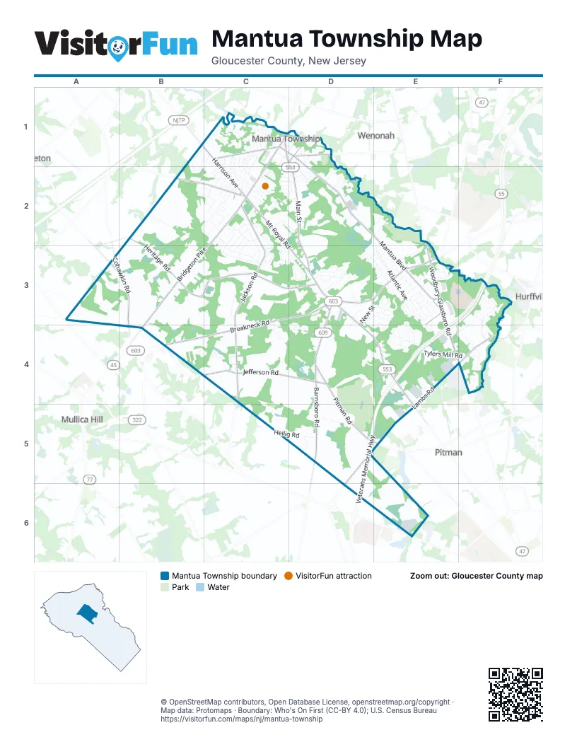
Street index of Mantua Township
Each street on the sheet and the grid squares it crosses.
- Veterans Memorial HighwayE3, F3, E4, D5, E5, D6
- Main StreetC1, D1, D2, D3, D4, E4, E5
- Bridgeton PikeC1, C2, B3, C3
- Woodbury-Glassboro RoadE2, E3, E4, F4
- Mt Royal RoadC2, C3, D3
- Harrison AvenueC1, C2
- Mantua PikeC1
- Mantua RoadC1
- North BroadwayE5
- Mantua BoulevardC1, D1, D2, E2, E3
- Lambs RoadE4, F4, D5, E5, D6
- Breakneck RoadC3, D3, B4, C4
- Barnsboro RoadD3, D4, D5
- Center StreetD3, E3
- Cohawkin RoadA3, B3
- Cedar RoadA3, B3
- Blackwood-Barnsboro RoadE3
- Heritage RoadB2, B3, C3, D3
- Jackson RoadC2, C3, C4
- Jefferson RoadB4, C4, D4
- Pitman RoadD4, D5
- Jessup Mill RoadB2, C2
- Berkley RoadC1
- Wenonah AvenueD1
- New StreetD3
- Norris StreetC1, D1
- Little Mill CourtC2
- Tylers Mill RoadD4, E4, F4
- Skyline CircleC2, D2
- Boodys Mill RoadB2, B3
- Tristram CircleC1, C2
- West Atlantic AvenueE3
- Crescent Hollow DriveD3, E3, D4, E4
- Candlewood DriveC3, D3
- Kristen LaneB1, C1, B2
- Cottage Gate CircleF3
- Atlantic AvenueE3
- Country Gardens BoulevardF3, F4
- Ravenswood WayE4
- Palomino CircleB2, C2
- Bethel Mill RoadF4
- Springhill RoadC1
- Carriage Hill CircleC2, D2
- Linden AvenueC1
- Lansing DriveC2, C3
- Heilig RoadC5, D5
- Montgomery DriveC3
- East Sussex AvenueE3
- Golf Club RoadD5
- Fairview DriveD3, E3
- Monroe AvenueC2
- Million Mosasaur WayE3, F3
- Rabbit Run RoadE4
- Lincoln AvenueC2
- Tony CircleC2
- Santa Fe DriveC2
- New York AvenueC2, D2
- Oakton DriveC2, C3
- Silver Creek DriveC2
- Schaub RoadC1, B2
- Madison RoadC3
- Franklin AvenueC1
- Creek LaneC1
- Sacramento DriveB2, C2
- Deerfield CircleD3
- Weatherby RoadC4
- Castle DriveC1, C2
- Meyers Creek CourtC3
- Pierre AvenueC2, C3
- Taylor AvenueC2
- Gray Fox CircleE3
- Buckingham DriveE3
- Cape May AvenueE2
- Hollybrook DriveD3
- Laurel DriveE4
- Crestmont DriveC3
- Church RoadE4, F4
- Tyler Lake RoadD4, E4
- Shadowbrook TrailB4
- Bismark AvenueC2, C3
- Barlow AvenueD2
- Lestershire DriveE3
- Royal Oaks DriveC3
- Trenton AvenueE3
- Columbus DriveC2
- West Elm AvenueC1
- Dirt RoadD5, E5
- Lantern WayC3, C4
- Surrey RoadE3, E4
- Rear DriveD5
- Brookview DriveC2, C3
- Central AvenueD1, D2
- Owens LaneD3
- Marathon DriveC2
- Evergreen AvenueD2
- Devonshire DriveE3
- Topeka AvenueC2, C3
- Twin Lakes DriveC1
- Wilson AvenueD3
- Washington AvenueC2
- Branch RoadF3, F4
- Timbercrest DriveE3
- Primrose CircleC1
- Greenwood DriveD3
- Adams AvenueC2
- Mockingbird LaneC2
- Elm AvenueD2, E5
- Arbour LaneE3
- Green LaneD5
- Woodbrook DriveC2
- Pendragon WayC1, C2
- Helena AvenueC2, C3
- Briar Patch LaneE3
- Willowbend DriveC2, C3
- Birchwood LaneC3
- East Morris AvenueE3
- Westwood DriveC2
- Glenwood AvenueC1
- Somerset AvenueE2
- Ash AvenueC1
- Horseshoe DriveC2
- Maplewood LaneC3, D3
- East Mercer AvenueE3
- Morning Dove CircleE4
- Turner StreetC1, D1
- Barry DriveC2
- Olympia StreetC2
- Phoenix AvenueC2
- East Warren AvenueE3
- Woodlawn AvenueC1
- Berry LaneD3
- East Essex AvenueE3
- East Union AvenueE3
- Susie's HollowD3
- Capital DriveC2
- Thornwood LaneE3
- South McCarthy AvenueD1, D2
- Maple AvenueD2
- State RoadC2
- Fawn DriveD4
- Livingstone RoadE3
- Frankfort AvenueC3
- Rambo RoadE4
- Winslow RoadE3
- Colosseum DriveC2
- Stepping Stone LaneF3
- Hillside TerraceC2
- Woodchuck WayE4
- Hampton AvenueC2
- Bergen AvenueE2
- Chestnut StreetC1
- New Jersey AvenueD2
- Florida AvenueD2
- Maryland AvenueD2
- West Landing RoadC2
- Deer Run CourtD3, D4
- Rosewood LaneD3, E3
- Humming Bird WayF3
- Eachus RoadC4
- West Hunterdon AvenueD3, E3
- Summit AvenueD1, D2
- Arena StreetC2
- Lavender CourtF3
- Hart LaneD4
- Loring LaneD3
- Old Landing RoadC1
- Kingsley RoadE3
- Rosewood CourtE3
- Sunflower WayC1
- East Cumberland AvenueE3
- Willingboro RoadE3
- McCarthy AvenueD1
- Firth DriveC1, C2
- Gilbreth ParkwayE6
- Cardinal AvenueC2
- Cliff CourtD3
- Bobolink AvenueC2
- Cornwall RoadE3
- Hibiscus CourtF3
- Legends LaneC2
- Spruce StreetE3
- West Cumberland AvenueE3
- Briarwood LaneD3
- Denver AvenueC2
- Boxwood CourtC2
- Hill StreetC1
- East Salem AvenueE3
- Stanhope AvenueC2, D2
- Eagle Ridge DriveC2
- Sherwood PlaceC2, C3
- Brougham AvenueC2, D2
- Hurff LaneD3, D4
- Shadow PlaceD1
- Crimson Court WestE3
- Martel StreetC1, D1
- Forest CourtC2
- Brittany StreetC1
- Cheyenne AvenueC2
- Gray Fox CourtE3
- West Sussex AvenueE3
- Clinton AvenueD1
- Lenape AvenueD1
- McAnally DriveE3
- Hidden Springs DriveC2
- Ferndale AvenueC1
- Whippoorwill WayC2
- Starling CourtC2
- Wishing Well LaneF3
- Meadow CourtE3
- Snapdragon CourtF3
- East Monmouth AvenueE3
- West Monmouth AvenueD3, E3
- Victoria AvenueC2, D2
- West Salem AvenueE3
- Monarch CourtF3
- Spruce AvenueE5
- Jackson AvenueC2
- Woodstream CourtC2
- Valley View DriveC2
- High StreetC1
- West Burlington AvenueD3
- Sport CourtC1
- Lilac CourtF3
- Vermont AvenueC2
- Bluejay DriveC2
- Dover RoadE3
- White Oak LaneE4
- Meadowlark AvenueC2
- Andrew AvenueC2
- Crimson Court EastE3
- Thackery CourtE3
- West Essex AvenueE3
- West Warren AvenueE3
- Appleblossom LaneC2
- Austin CourtC3
- Carriage Hill DriveC2, D2
- Sangreal CourtC2
- Roslyn DriveC1
- Pine StreetE3
- Pine Brook DriveC3
- Tatum StreetC1, D1
- Overbrook AvenueE2
- Friesa CourtC2
- East Atlantic AvenueE3
- Ridgeview CourtD3
- Tonkin StreetC1
- Chestnut AvenueD2
- West Union AvenueE3
- Bismark CourtC2
- Hialiah AvenueD1
- East Hunterdon AvenueE3
- Quest CourtC2
- Glover RoadC4
- Duffield RoadC4
- Redbud LaneC1
- Warwick CourtD2
- Hudson AvenueE5
- George's AlleyC1
- Beech RoadC2
- Goldfinch DriveC2
- Tallowood CourtC2, C3
- DeForest ParkwayE6
- Woodcrest CourtC3, D3
- Passaic AvenueE3
- Balin CourtC1
- Oxford TerraceE3
- Berkley Crossing DriveC1
- Norwood AvenueC1
- Hirst AvenueD1
- Quail CourtE4
- Robins WayC2
- Barney Hawkin RoadA3
- Accolon CourtC1, C2
- Boise AvenueC2
- West Mercer AvenueE3
- Avondale CourtC1
- Elizabeth AvenueD2
- Woodmont CourtC3
- Pellinore CourtC1
- Galahad CourtC1
- Morton LaneC1
- West Morris AvenueE3
- Sacramento CourtC2
- Bluebird RoadC2
- Snowy Owl CourtE3, E4
- Cottonwood CourtD3
- Woodleigh CourtC3
- Trotters CourtC2
- Pine Mill RoadB2
- White Tail CourtE4
- Sheffield RoadE3
- Long TerraceC2
- Nashville RoadC3
- Arbour CourtE3
- Aspenwood CourtC2
- Arsen DriveC2
- Olympia CourtC2
- Laramie WayC2
- Gaudet CourtC2
- Applewood CourtD3
Things to do on the Mantua Township map
Places on the map
- Barnsboro Bible Church
- Barnsboro Inn
- Cedar Lake
- Ceres Park & Nature Preserve
- Chestnut Branch Park
- Chick-fil-A
- Dippy's Ice Cream
- Driving Range
- Dunkin'
- Edelman Fossil Park and Museum of Rowan University
- Emerald Lake
- Helen Kramer Landfill
- Heritages Dairy
- J G Cook's Carolina Blue
- Kohl's
- Lipari Landfill
- Lowe's
- Luke Oil
- Lukoil
- Mantua Community Center
- Mantua Little League
- Mantua Township Historical Commission
- Mantua Volunteer Fire Company
- Marl Lakes
- Pitman Golf Course
- Practice Green
- Sewell
- Sewell Post Office
- South Jersey Technology Park
- Target
- Telford Inn
- The Home Depot
- Total Turf Experience
- Township of Mantua Justice Complex and Police Department
- Township of Mantua Municipal Building
- Tylers Mill Pond
- US Post Office
- Walgreens
- Wawa
- Wenonah Cemetery
Next to Mantua Township
- Hurffville
- Mullica Hill
- Pitman
- Wenonah
© OpenStreetMap contributors, Open Database License, openstreetmap.org/copyright · Map data: Protomaps · Boundary: Who's On First (CC-BY 4.0); U.S. Census Bureau















