

New Jersey map
Wall Township map
About 26,722 people live here (Census Bureau, 2024 estimate). The sheet's index lists 300 streets; Garden State Parkway, River Road and Belmar Boulevard cross the most grid squares. Also on it: Allaire State Park, Allenwood and Brick Reservoir.
Open the map (PDF, US Letter)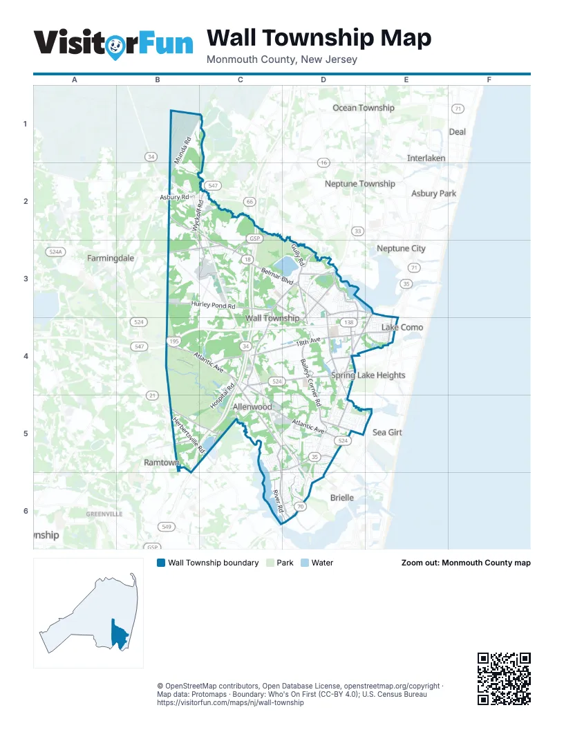
Street index of Wall Township
Each street on the sheet and the grid squares it crosses.
- Garden State ParkwayC2, C3, C4, B5, C5
- Central Jersey ExpresswayB4, C4
- Allaire RoadB4, C4, D4
- River RoadE3, D4, E4, C6, D6
- Wyckoff RoadB2, C2, C3
- Route 71E4
- Asbury RoadB2
- Shafto RoadC2
- New Jersey Highway 34B2
- Manasquan CircleD5
- Collingwood CircleB2
- Belmar BoulevardB3, C3, D3, E3
- Atlantic AvenueB4, C4, C5, D5
- Allenwood RoadC3, D3, C4
- Ramshorn DriveC5, C6, D6
- Herbertsville RoadB5, C5
- Old Bridge RoadD6
- Riverview DriveD6
- 18th AvenueC4, D4, E4
- West Hurley Pond RoadB3, C3
- New Bedford RoadD3, D4, D5
- Baileys Corner RoadD4, D5
- Lakewood RoadC5, D5
- Old Mill RoadD4, D5
- Lakewood-Allenwood RoadB5, C5
- Megill RoadB2, C2, C3
- Marconi RoadD3, D4
- Monmouth BoulevardD3, D4
- Squankum-Allenwood RoadB5, C5
- West 18th AvenueC4
- Gully RoadD3
- Glendola RoadD3, D4
- Sea Girt AvenueD5
- Ridgewood RoadC4, C5, D5
- Schoolhouse RoadC2, C3
- Hurley Pond RoadB3, C3, D3, D4
- Industrial RoadB3, C3
- Brighton AvenueD3
- Morningstar RoadD6
- Paynters RoadC5, D5
- Wall Church RoadD4
- 8th AvenueD5, E5
- Remsen Mill RoadD3
- Warren AvenueD4
- Meetinghouse RoadD5
- Metedeconk RoadC5
- Bedford Corners LaneD3
- North Main StreetD5
- Sally Ike RoadC5
- Union LaneD6
- Munda RoadB1, B2
- Hospital RoadC4, B5, C5
- Orchard Crest BoulevardD5
- Martin RoadC3
- Campus ParkwayC2
- Tiltons Corner RoadC5, D5
- Apple Ridge CircleD5
- West Chicago BoulevardD5, E5
- Campbell RoadC4
- Ocean RoadD4, D5
- 17th AvenueE4
- Algonkin TrailD5, D6
- Garrett DriveD5
- Woodfield AvenueC3
- Shadowbrook DriveD5
- Church StreetD5
- Celeste DriveC4, D4
- Lincoln AvenueD3, D4
- Holly BoulevardC5, D5
- Shark River RoadB1, B2, C2
- Oval RoadD6
- Washington AvenueD3
- Laurel AvenueD5
- Collier RoadD6
- Governours CrossingD3
- Curtis AvenueE4
- Arthur StreetD3
- Alicia DriveD3
- Shoreline DriveC5
- Westminister LaneC3, D3
- Dubac RoadD4
- Bentz RoadD4
- Concord DriveD4
- Lenape TrailD5, D6
- Tarpon DriveD5
- Grant StreetD3
- Wooley RoadD4
- Racquet RoadD4
- Cooper BoulevardD5, D6
- Tennis CourtD4
- New Brunswick AvenueD5
- Horseshoe DriveD6
- Jeanne Marie CourtB5
- Vincent CourtC4
- Outlook DriveB2, C2
- Allenwood-Lakewood RoadB5, C5
- 1st AvenueE4, C5
- M StreetE3, E4
- Winesap DriveD5
- Manito RoadD5
- Woodfield RoadC3
- Carmerville RoadB3, B4
- Bay PlazaD3
- Green Meadow WayC2
- Village RoadD5
- Riverside TerraceC5
- Cedar StreetC5
- Narrumson RoadD5
- Watson AvenueD3
- Williamsburg DriveD4
- Windsor RoadC3, D3
- Rogers CourtD3, D4
- Landmark PlaceC5
- Magnolia AvenueD5
- East Hurley Pond RoadD4
- Minnehaha TrailD5
- Spring StreetC3
- Starboard WayC2
- Minnesink RoadD5
- Ohadi DriveD4
- Terrace PlaceD5, E5
- Harrison StreetD3
- Mohegan RoadD5
- Johnson StreetD3
- Hidden Brook DriveD5
- Hunters LaneC3, D3
- Azure AvenueC3
- Robin WayC5, D5
- Constitution WayD3
- Dunroamin RoadC3
- Sparrowbush LaneD5, D6
- Waterview WayD3
- Cortland DriveD5
- South Manor CourtD4
- Brandon RoadC3, D3
- Easy StreetB5
- Overbrook DriveC3
- Misty Hollow DriveC3
- Sycamore StreetC5
- Marshall RoadB2
- 5th AvenueE4
- Pierce StreetD3
- Winter View RoadD5
- McKinley StreetD3
- Hemlock AvenueD5
- Pacific AvenueD3
- Oak RoadD5
- Brinley RoadC4
- Edgemere RoadD3
- Pennsylvania AvenueD5
- L StreetE4
- Adams StreetD3, D4
- Garfield StreetD3
- Broad StreetC3
- Ivanhoe PathD5
- Butternut RoadD5
- Jefferson AvenueD5
- Gregory PlaceD5
- Walton WayC3
- Birch PlaceC5
- Lantern Light WayD6
- Valley DriveD3
- Myrtle AvenueC5
- Gladfield DriveD5
- 4th AvenueE4
- Heathrow LaneD6
- Ymca RoadB5
- Roosevelt StreetD3
- Parkwood DriveC4
- Beverly StreetD3, D4
- Cherry StreetC5
- Oakwood RoadE4
- Spring Lake Gardens CourtD4
- Rolling Hills WayD5
- Hawthorne ParkwayD4, E4
- Cypress StreetC5
- Pippin DriveD5
- New York AvenueD5
- Clayton DriveD3
- Crestview RoadD5, D6
- Beech StreetC5
- Shore DriveD3
- Buchannon StreetD3
- Hinck DriveD3
- Deuce DriveD4
- Marigold AvenueC5
- Hayes StreetD3
- Philadelphia AvenueD5
- Newark AvenueD5
- Windfield DriveD5
- West Union LaneD6
- Fox Field CircleC3, D3
- Cleveland AvenueD3
- Rogers RoadD3
- Bailey RoadD3, D4
- Candlewood LaneD5
- Frances DriveD3
- Randolph WayC3, D3
- Harbor RoadD6
- Kelly LaneB2
- Wall Stadium SpeedwayC3
- Campmeeting StreetE4
- Sterling DriveC6, D6
- Carriage Hill DriveC4, D4
- Adrienne RoadD3
- Sheridan DriveC3
- Evans RoadD3
- Hill BoulevardB3
- Chapel LaneB2, C2
- Pascal PlaceD4
- Murray DriveC4
- Tally Ho DriveC3, D3
- K StreetE4
- Barbara LynnE5
- 6th AvenueE4
- Pomerton RoadD3
- Bradford RunD4
- Emerson AvenueD4
- Maxwell DriveD3, D4
- Millbrook RoadD5
- Morris LaneD3
- World StreetE4
- Sunset TerraceD4
- Cammar DriveD3
- Troy DriveD4
- Laurel CourtC5, D5
- Tanner AvenueD6
- Hilltop DriveE4
- Quaker StreetC3
- Woodland AvenueE4
- Arnold AvenueB3, C3
- West Side DriveC5
- Wildwood AvenueD5
- Glenn StreetE4
- Juliette DriveD3
- Mahogany TrailD6
- Central AvenueE4
- Cottage PlaceE4
- Justin CircleB2
- Butler WayD3
- Oakshire LaneC6, D6
- Airport RoadC3
- Maple StreetD3
- Saw Mill LaneC5
- Liberty LaneD3
- Camden AvenueD5
- Sherwood DriveD5
- Crystal Brook DriveD5
- Joseph CourtC4
- Colonial RoadD4
- Grove StreetE4
- Giardina CourtD4
- America StreetE4
- Newport BoulevardC2
- Heritage CourtC3
- Meadow RoadE4
- Kennedy DriveD3
- West Magnolia AvenueD5
- Rambling Hill CourtC4, C5
- 3rd AvenueE4
- Pilgrim RoadC3
- I StreetE4
- Toboggan RunC6, D6
- Anchor Bay RoadC2
- People StreetE4
- Preakness CourtD4
- Crescent DriveD5
- Samuel DriveD4, D5
- Princton CourtC5
- Summit RoadD5, D6
- Chalet DriveD6
- Deer Run DriveD6
- Crabapple DriveD5
- Autumn DriveC5, C6
- Walnut StreetD3
- Fox LaneD6
- Lawrence WayD5
- Riverview TerraceE4
- Nantucket LaneC2
- Boxwood DriveD5
- Tecumseh PlaceD5
- Benjamin CircleD4
- Spruce DriveD5
- Harvest LaneD6
- Theater DriveB2
- Evergreen AvenueD5
- Romano BoulevardD3
- Ruta BoulevardD3
- Willow DriveD5
- Diana RoadD3
- Sandpiper WayC5
- Cottonwood DriveD5
- Briarwood AvenueD5
- Red Gate RoadC5
- Helen StreetD4
- Ace DriveD4
- Ambassador CourtC3
- Doris StreetC3
- Grace StreetC3
- Geraldine CourtC4
Places on the map
- Albert Pond
- Allaire Community Farm
- Allaire Corporate Center
- Allaire State Park
- Allaire State Park Group Campground
- Allaire Village
- Allenwood
- Allenwood Elementary School
- Atlantic View Cemetery
- Autumn Ridge
- Bel-Aire Golf Course
- Boy Scout Trail
- Brick Reservoir
- Brisbane Lake
- Brook 35 & West
- Camp Evans Historic District
- Central Elementary School
- Circle Factory Outlet Center
- Community Park
- Daydream Farm
- Glendola Reservoir
- Golf Kings
- Hincks Turkey Farm
- Hurleys Pond
- Judy Blume Service Area
- Monmouth Boulevard
- Monmouth Executive Airport
- Monmouth Shores Corporate Park
- North Wall Little League
- Old Mill Pond
- Osborne Pond
- Pine Creek Railroad
- Pine Grove Day Camp
- Preferred Care at Wall
- Saint Catharine Cemetery
- Shark River Park
- South Wall Little League
- Spring Meadow Golf Course
- Wall Stadium Speedway
- West Belmar
Next to Wall Township
- Allenhurst
- Asbury Park map
- Bradley Beach
- Brielle
- Deal
- Farmingdale
- Greenville
- Interlaken
- Lake Como
- Manasquan
- Neptune City
- Neptune Township
- Ocean Township map
- Point Pleasant Beach
- Ramtown
- Sea Girt
- Spring Lake
- Spring Lake Heights
© OpenStreetMap contributors, Open Database License, openstreetmap.org/copyright · Map data: Protomaps · Boundary: Who's On First (CC-BY 4.0); U.S. Census Bureau















